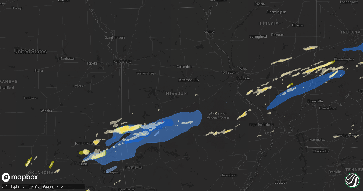
Hail Map in Missouri on April 29, 2025
Get this storm
April 29 map
$229
one time, instant access
Download today. No call, no setup
Keep the $229
Bought the map and want the full workflow? Apply the entire $229 to a subscription within 7 days. None of it is wasted.
Every map, not just this one
This buys you this map. Subscription and you get every map we run, in the markets you choose from a few cities to whole states to nationwide. Plus real-time alerts the moment a storm fires.
Contact data
Name, contact info, occupancy, even credit band for addresses in the footprint. You go from where it hit to who to call.
Become the source they trust
Unlimited branding weather history reports on demand. You already have the documented answer ready for the property owner, and you are the one who showed up with it.
Property data and RoofTrace estimates
Pull up any address you have got, its value and the exact code rules for that jurisdiction, straight from One Click Code. Then RoofTrace estimates the squares, pitch, and roof value, priced the way you price.
Storm reports in Missouri
Missouri
| Date | Description |
|---|---|
| 04/29/20251:06 PM CDT | Tree down over road at state route o and highway 32. Time estimated from radar. |
| 04/29/202512:30 PM CDT | Church steeple blown over. |
| 04/29/202512:29 PM CDT | Roof blown off school. Time estimated by radar. |
| 04/29/202511:19 AM CDT | Via social media... Delayed report of tree blown across highway at hwy 119 and vv junction. Time based on radar. |
| 04/29/202510:55 AM CDT | Photos of snapped trees down on home from regional skywarn. |
| 04/29/20259:55 AM CDT | Tree over powerlines. |
| 04/29/20259:48 AM CDT | Pictures of large trees down and damage to green house. Time based on radar estimate. |
| 04/29/20259:48 AM CDT | Tree limbs of 3 inch diameter being reported snapped in fair grove area. Time based on radar estimate. |
| 04/29/20259:45 AM CDT | Trees on house... 7 outbuildings have trees or roof damage. Time based on radar estimate. |
| 04/29/20259:45 AM CDT | Facebook photo of significant roof damage to aurora church of christ. |
| 04/29/20259:42 AM CDT | Tree blocking road division and benton. |
| 04/29/20259:40 AM CDT | Facebook photo of uprooted tree. |
| 04/29/20259:40 AM CDT | Trees down in the road of u and finbrooke. |
| 04/29/20259:36 AM CDT | 2-3 trees have feel over broadway... Half the road is blocked. About 4 ft in diameter. Time based on radar. Ouse on east ave. |
| 04/29/20259:36 AM CDT | 2-3 trees have feel over broadway... Half the road is blocked. About 4 ft in diameter. Time based on radar. |
| 04/29/20259:36 AM CDT | Pictures of trees down with some on house. Time based on radar. |
| 04/29/20259:35 AM CDT | Delayed report. Branches down even some trees down. Only one critical damage spotted so far was one shed destroyed by fallen trees. |
| 04/29/20259:35 AM CDT | Branches up to 4 in down... And a large tree 5ft in diameter... In springfield. Tree was split in half... And shingles blown off of roofs in the area. Time based on rad |
| 04/29/20259:34 AM CDT | A local report indicates 90 MPH wind near 5 SSE Willard |
| 04/29/20259:34 AM CDT | A local report indicates 90 MPH wind near 5 SSE Willard |
| 04/29/20259:34 AM CDT | Spotter report of a house that has half collapsed at the golf course near scenic and sunshine. Time based on radar estimate. |
| 04/29/20259:34 AM CDT | Corrects previous tstm wnd dmg report from 3 wsw springfield. Spotter report of a house tree over the house i previously reported on came down on house and collapsed pa |
| 04/29/20259:33 AM CDT | Spotter reported semi truck laid over on the west bound lane of i-44 at the bridge at the 75.0 mile marker. Time based on radar estimate. |
| 04/29/20259:33 AM CDT | Trees down at drury university. Time based on radar estimate. |
| 04/29/20259:32 AM CDT | Large tree down. |
| 04/29/20259:32 AM CDT | Large tree down |
| 04/29/20259:32 AM CDT | Multiple tree branches down with hole in roof. |
| 04/29/20259:32 AM CDT | Multiple trees down. Uprooted. Multiple trees snapped. Power line down... Power poles snapped. Structural and roof damage. Time based on radar. |
| 04/29/20259:32 AM CDT | A local report indicates 82 MPH wind near 5 SSE Willard |
| 04/29/20259:32 AM CDT | Large tree down covering road. |
| 04/29/20259:31 AM CDT | 2700 block of north glenstone... Several utility poles and lines down across the road on the east side outer road near the steak and shake. Time based on radar. |
| 04/29/20259:31 AM CDT | Fort and harrison tree down across the power lines. Lots of tree damage at mt vernon and fort in springfield. Time based on radar estimates. |
| 04/29/20259:30 AM CDT | Spotter reported tree over power lines at portland and robberson in springfield. |
| 04/29/20259:30 AM CDT | Large tree branches down and power lines. |
| 04/29/20259:30 AM CDT | A nws survey found that a brief... Weak ef-0 tornado began at 9:30 am near eaglecrest st. With maximum wind speeds of 85 mph... A path length of 0.53 miles... And a pat |
| 04/29/20259:30 AM CDT | 3ft diameter trees blown into parking lots. Time based on radar estimate. |
| 04/29/20259:30 AM CDT | 5ft diameter tree fallen across road |
| 04/29/20259:30 AM CDT | Tree on house. |
| 04/29/20259:30 AM CDT | Tree on house. |
| 04/29/20259:30 AM CDT | Structural damage roof hwy ab and ee. |
| 04/29/20259:30 AM CDT | Several tree limbs downed in north springfield. |
| 04/29/20259:30 AM CDT | Trees down. |
| 04/29/20259:30 AM CDT | A local report indicates 75 MPH wind near 5 SSE Willard |
| 04/29/20259:30 AM CDT | Roof damage on east divison about 300 to 400 yrds west from the airport... And kolor 10s studio. Time based on radar. |
| 04/29/20259:28 AM CDT | A local report indicates 64 MPH wind near 6 SSE Willard |
| 04/29/20259:27 AM CDT | Corrects previous tstm wnd gst report from nixa. Spotter report: 87 mph winds nixa most town has no power. |
| 04/29/20259:25 AM CDT | Facebook photo of large tree uprooted that has crushed car. |
| 04/29/20259:24 AM CDT | Delayed report via social media of significant wind damage to the gas station on the corner of ab and mo ee. Time based on radar. |
| 04/29/20259:24 AM CDT | Trees across road hw t and ee. |
| 04/29/20259:24 AM CDT | Barn sustained damage. |
| 04/29/20259:24 AM CDT | Tree down on bridge. Time based on radar estimate. |
| 04/29/20259:24 AM CDT | Corrects previous tstm wnd dmg report from 2 wsw highlandville for time. Trees down blocking the highway. |
| 04/29/20259:24 AM CDT | Tree down on o hwy right by alder road. Time based on radar estimate. |
| 04/29/20259:21 AM CDT | Photos sent via facebook messenger of small outbuilding blown down... Section of chain link fence blown over. |
| 04/29/20259:20 AM CDT | Damage to signs at hoods truck stop. Time based on radar estimates. |
| 04/29/20259:19 AM CDT | Tree down across county line road covering west bound lane. Time based on radar. |
| 04/29/20259:18 AM CDT | Tree down. Time based on radar. |
| 04/29/20259:18 AM CDT | Significant damage at elliott and hadley and aurora... Missouri. |
| 04/29/20259:18 AM CDT | Tree down blocking roadway. Time based on radar. |
| 04/29/20259:17 AM CDT | Quarter size hail and debris hwy n and lawrence 2100. |
| 04/29/20259:16 AM CDT | Tree covering road hwy p between clever and republic. |
| 04/29/20259:13 AM CDT | Tree down. Time based on radar. |
| 04/29/20259:13 AM CDT | Storm damage and debris. Time based on radar estimate. |
| 04/29/20259:06 AM CDT | Mesonet station gw5516 mt vernon. |
| 04/29/20259:05 AM CDT | Vehicle wrapped up in powerlines at business 60 and 60 aurora... Missouri. |
| 04/29/20259:00 AM CDT | An nws survey found that an ef-1 tornado began at 9:00 am near highway 60 between verona and aurora and ended in southern aurora just west of highway 39. The tornado ha |
| 04/29/20259:00 AM CDT | Corrects previous tstm wnd dmg report from 1 s aurora for time. Facebook photo of significant roof damage to aurora church of christ. Time based on radar. |
| 04/29/20259:00 AM CDT | House is gone. Time based on radar estimate. |
| 04/29/20259:00 AM CDT | Severe home damage. Time based on radar estimate. |
| 04/29/20259:00 AM CDT | House damage. Time based on radar damage. |
| 04/29/20258:56 AM CDT | Report of possible tornado that passed through 8066 lawrence 2205 monett. Trees and power lines down per resident. |
| 04/29/20258:56 AM CDT | Tree on house off highway h monett area. |
| 04/29/20258:52 AM CDT | Large trees down. |
| 04/29/20258:50 AM CDT | Lots of trees down. |
| 04/29/20258:50 AM CDT | Tree and power lines down. |
| 04/29/20258:37 AM CDT | Report from mping quarter 1.00 in. |
| 04/29/20258:36 AM CDT | Report from mping golf ball 1.75 in. |
| 04/29/20258:36 AM CDT | Heavy rain and strong wind est 50-60 mph ne of neosho. |
| 04/29/20258:35 AM CDT | I went outside after the storm that passed came through and my i had 2-3 trees snapped in half and they were thick beautiful trees. Possible tornado. |
| 04/29/20258:35 AM CDT | Social media post pictures of significant wind damage to barns and out buildings. Time based on radar. Delayed report. |
| 04/29/20258:33 AM CDT | A local report indicates 1.00 inch wind near Webb City |
| 04/29/20258:29 AM CDT | Report from mping quarter 1.00 in. |
| 04/29/20258:27 AM CDT | Possible tornado damage at the 23 mm i 49 southbound south of neosho in newton county. Part of a barn is blocking the interstate with multiple trees down in a defined p |
| 04/29/20258:25 AM CDT | Report from mping... Quarter 1.00 in. |
| 04/29/20258:24 AM CDT | Large tree down. |
| 04/29/20258:22 AM CDT | Hail at webb city... Been going on about 3 minutes. |
| 04/29/20258:20 AM CDT | 1.65 inch hail. |
| 04/29/20258:15 AM CDT | A local report indicates 1.00 inch wind near 2 S Iron Gates |
| 04/29/20258:15 AM CDT | A local report indicates 1.00 inch wind near 2 S Iron Gates |
| 04/29/20258:14 AM CDT | Seeing some rotation of clouds. |
All States Impacted by Hail Map on April 29, 2025
Cities Impacted by Hail Map on April 29, 2025
- McCune, KS
- Cherokee, KS
- Delaware, OK
- Coffeyville, KS
- Nowata, OK
- Lenapah, OK
- Red Bud, IL
- S Coffeyville, OK
- Baldwin, IL
- Collinsville, OK
- Ramona, OK
- Vera, OK
- Ochelata, OK
- Skiatook, OK
- Pittsburg, KS
- Sperry, OK
- Owasso, OK
- Tulsa, OK
- Claremore, OK
- Oswego, KS
- Edna, KS
- Bartlett, KS
- Girard, KS
- Vinita, OK
- Talala, OK
- Oologah, OK
- Marissa, IL
- Coulterville, IL
- Westfield, IL
- Ashmore, IL
- Casey, IL
- New Athens, IL
- Lenzburg, IL
- Weir, KS
- Welch, OK
- Chelsea, OK
- Tilden, IL
- Sparta, IL
- Adair, OK
- Pryor, OK
- Big Cabin, OK
- Chetopa, KS
- Scammon, KS
- Oakdale, IL
- Nashville, IL
- Martinsville, IL
- Marshall, IL
- Kansas, IL
- Paris, IL
- Frontenac, KS
- Mindenmines, MO
- Columbus, KS
- Ramsey, IL
- Vandalia, IL
- Addieville, IL
- Strang, OK
- Spavinaw, OK
- Brownstown, IL
- Beecher City, IL
- Saint Elmo, IL
- Dennison, IL
- Riverton, KS
- Galena, KS
- Joplin, MO
- Miami, OK
- North Miami, OK
- Commerce, OK
- Carl Junction, MO
- Asbury, MO
- Afton, OK
- Ketchum, OK
- Eucha, OK
- Jay, OK
- Grove, OK
- Wyandotte, OK
- Webb City, MO
- Oronogo, MO
- Altamont, IL
- Odin, IL
- Baxter Springs, KS
- West Terre Haute, IN
- Salem, IL
- Fairland, OK
- Sheldon, MO
- Lamar, MO
- Effingham, IL
- Shumway, IL
- Carterville, MO
- Carthage, MO
- Diamond, MO
- Duenweg, MO
- Purcell, MO
- Jasper, MO
- Neck City, MO
- Alba, MO
- Gravette, AR
- South West City, MO
- Anderson, MO
- Noel, MO
- Tiff City, MO
- Goodman, MO
- Seneca, MO
- Neosho, MO
- Pineville, MO
- Lanagan, MO
- Texico, IL
- Bluford, IL
- Kinmundy, IL
- Iuka, IL
- Xenia, IL
- Louisville, IL
- Kell, IL
- Teutopolis, IL
- Granby, MO
- Stella, MO
- Powell, MO
- Rocky Comfort, MO
- Stark City, MO
- Wheaton, MO
- Exeter, MO
- Fairview, MO
- Purdy, MO
- Pierce City, MO
- Wentworth, MO
- Reeds, MO
- Avilla, MO
- Sigel, IL
- La Russell, MO
- Sarcoxie, MO
- Golden City, MO
- Monett, MO
- Stotts City, MO
- Butterfield, MO
- Cassville, MO
- Miller, MO
- Lockwood, MO
- Verona, MO
- Mount Vernon, MO
- Freistatt, MO
- Aurora, MO
- Crane, MO
- Claremont, IL
- Dundas, IL
- Newton, IL
- Ingraham, IL
- South Greenfield, MO
- Marionville, MO
- Galena, MO
- Billings, MO
- Ash Grove, MO
- Nixa, MO
- Clever, MO
- Bois D Arc, MO
- Republic, MO
- Halltown, MO
- Everton, MO
- Inola, OK
- Chouteau, OK
- Locust Grove, OK
- Salina, OK
- Rose, OK
- Colcord, OK
- Kansas, OK
- Gentry, AR
- Maysville, AR
- Bentonville, AR
- Decatur, AR
- Rogers, AR
- Centerton, AR
- Pea Ridge, AR
- Hiwasse, AR
- Sulphur Springs, AR
- Seligman, MO
- Bella Vista, AR
- Washburn, MO
- Bridgeport, IL
- Flat Rock, IL
- Sumner, IL
- West Liberty, IL
- Willard, MO
- Brookline, MO
- Ozark, MO
- Walnut Grove, MO
- Springfield, MO
- Rogersville, MO
- Fair Grove, MO
- Oblong, IL
- Robinson, IL
- Oaktown, IN
- Palestine, IL
- Willow Hill, IL
- Lawrenceville, IL
- Carlisle, IN
- Highlandville, MO
- Cape Fair, MO
- Ponce De Leon, MO
- Reeds Spring, MO
- Spokane, MO
- Chestnutridge, MO
- Walnut Shade, MO
- Forsyth, MO
- Garrison, MO
- Oldfield, MO
- Sparta, MO
- Taneyville, MO
- Chadwick, MO
- Strafford, MO
- Marshfield, MO
- Fordland, MO
- Bruner, MO
- Pleasant Hope, MO
- Linton, IN
- Merom, IN
- Sullivan, IN
- Brighton, MO
- Elkland, MO
- Buffalo, MO
- Conway, MO
- Seymour, MO
- Niangua, MO
- Ava, MO
- Bradleyville, MO
- Mansfield, MO
- Squires, MO
- Bolivar, MO
- Lyons, IN
- Switz City, IN
- Worthington, IN
- Bloomfield, IN
- Dugger, IN
- Sandborn, IN
- Norwood, MO
- Grovespring, MO
- Phillipsburg, MO
- Macomb, MO
- Hartville, MO
- Lebanon, MO
- Louisburg, MO
- Half Way, MO
- Allen, OK
- Drury, MO
- Mountain Grove, MO
- Falcon, MO
- Lynchburg, MO
- Atwood, OK
- Laquey, MO
- Graff, MO
- Paragon, IN
- Martinsville, IN
- Morgantown, IN
- Trafalgar, IN
- Franklin, IN
- Bargersville, IN
- Plato, MO
- Huggins, MO
- Cabool, MO
- Houston, MO
- Bucyrus, MO
- Success, MO
- Roby, MO
- Licking, MO
- Waynesville, MO
- Duke, MO
- Fort Leonard Wood, MO
- Edinburgh, IN
- Needham, IN
- Shelbyville, IN
- Boggstown, IN
- Vichy, MO
- Vienna, MO
- Solo, MO
- Yukon, MO
- Raymondville, MO
- Eunice, MO
- Hartshorn, MO
- Fairland, IN
- Manilla, IN
- Morristown, IN
- Arlington, IN
- Beulah, MO
- Edgar Springs, MO
- Newburg, MO
- Salem, MO
- Lenox, MO
- Homer, IN
- Rushville, IN
- Waldron, IN
- Milroy, IN
- Seymour, IN
- Columbus, IN
- Flat Rock, IN
- Rolla, MO
- Bluejacket, OK
- Glenwood, IN
- Quapaw, OK
- Picher, OK
- Treece, KS
- Connersville, IN
- Laurel, IN
- Greensburg, IN
- Scipio, IN
- North Vernon, IN
- Butlerville, IN
- Elizabethtown, IN
- Jonesville, IN
- Birch Tree, MO
- Metamora, IN
- Liberty, IN
- Brookville, IN
- Hope, IN
- Saint Paul, IN
- Batesville, IN
- Oldenburg, IN
- Holton, IN
- Versailles, IN
- Osgood, IN
- Westport, IN
- Winona, MO
- Eminence, MO
- Boss, MO
- Goshen, KY
- Milan, IN
- Cedar Grove, IN
- New Trenton, IN
- West Harrison, IN
- Brownsville, IN
- Centerville, IN
- Richmond, IN
- Eaton, OH
- Boston, IN
- Camden, OH
- West College Corner, IN
- College Corner, OH
- Oxford, OH
- Bath, IN
- Hamilton, OH
- Okeana, OH
- Vian, OK
- La Grange, KY
- Crestwood, KY
- Van Buren, MO
- Bunch, OK
- Sallisaw, OK
- Somerville, OH
- West Alexandria, OH
- Lewisburg, OH
- Dillsboro, IN
- Moores Hill, IN
- Guilford, IN
- Aurora, IN
- Sunman, IN
- Piedmont, MO
- Ellington, MO
- Stilwell, OK
- Ellsinore, MO
- Brookville, OH
- Germantown, OH
- New Lebanon, OH
- Farmersville, OH
- Fredericktown, MO
- Mill Spring, MO
- Cleves, OH
- Cincinnati, OH
- Perryville, MO
- Patton, MO
- Patterson, MO
- Fort Stockton, TX
- Potosi, MO
- Dayton, OH
- Vandalia, OH
- Clayton, OH
- Englewood, OH
- Tipp City, OH
- Troy, OH
- New Carlisle, OH
- Medway, OH
- Springfield, OH
- Urbana, OH
- Tremont City, OH
- North Hampton, OH
- Saint Paris, OH
- West Milton, OH
- Imperial, TX
- Silva, MO
- North Bend, OH
- Greenville, MO
- Plain City, OH
- West Jefferson, OH
- Amlin, OH
- Dublin, OH
- Delaware, OH
- Powell, OH
- Hilliard, OH
- Lewis Center, OH
- Westerville, OH
- Columbus, OH
- Galloway, OH
- Galena, OH
- New Albany, OH
- Sunbury, OH
- Johnstown, OH
- Pleasureville, KY
- Bethlehem, KY
- New Castle, KY
- Smithfield, KY
- Sulphur, KY
- Pendleton, KY
- Ashley, IL
- Okawville, IL
- Eminence, KY
- Richview, IL
- Sims, IL
- Geff, IL
- Meadow, TX
- Ropesville, TX
- Wayne City, IL
- Vergennes, IL
- Campbellsburg, KY
- Keenes, IL
- Owenton, KY
- Lockport, KY
- Flora, IL
- Odonnell, TX
- Tahoka, TX
- Clay City, IL
- Noble, IL
- Perry Park, KY
- Turners Station, KY
- Cisne, IL
- Crane, TX
- Wolfforth, TX
- Lubbock, TX
- Attica, NY
- Warsaw, NY
- Olney, IL
- Varysburg, NY
- Anna, IL
- Makanda, IL
- Carbondale, IL
- Cobden, IL
- Johnsonville, IL
- Dale, NY
- Wyoming, NY
- Pavilion, NY
- Piffard, NY
- Centralia, IL
- East China, MI
- Marine City, MI
- Cannelburg, IN
- Montgomery, IN
- Strykersville, NY
- Vincennes, IN
- Pinckneyville, IL
- Hoyleton, IL
- Georgetown, KY
- Sadieville, KY
- Woodlawn, IL
- Bicknell, IN
- Ragsdale, IN
- Sikeston, MO
- Loogootee, IN
- York, NY
- Avon, NY
- Caledonia, NY
- Linwood, NY
- Ewing, IL
- Belle Rive, IL
- Ina, IL
- Elnora, IN
- Plainville, IN
- Washington, IN
- Edwardsport, IN
- Post, TX
- Crane, IN
- Cynthiana, KY
- Reynoldsburg, OH
- Millersport, OH
- Etna, OH
- Baltimore, OH
- Blacklick, OH
- Pataskala, OH
- Hebron, OH
- Heath, OH
- Kirkersville, OH
- Zanesville, OH
- Granville, OH
- Hopewell, OH
- Mount Perry, OH
- Glenford, OH
- Jacksontown, OH
- Alexandria, OH
- Buckeye Lake, OH
- Thornville, OH
- Nashport, OH
- Norwich, OH
- New Concord, OH
- Chandlersville, OH
- Newark, OH
- Frazeysburg, OH
- Saint Louisville, OH
- Adamsville, OH
- Dresden, OH
- Trinway, OH
- Cambridge, OH
- Kipling, OH
- Lore City, OH
- Byesville, OH
- Cumberland, OH
- Pleasant City, OH
- Quaker City, OH
- Salesville, OH
- Old Washington, OH
- Senecaville, OH
- Kimbolton, OH
- Java Village, NY
- North Java, NY
- Holland, NY
- Jerusalem, OH
- Barnesville, OH
- Piedmont, OH
- Freeport, OH
- Flushing, OH
- Cadiz, OH
- Bethesda, OH
- Port Washington, OH
- Smithfield, OH
- Saint Clairsville, OH
- Mingo Junction, OH
- Steubenville, OH
- Morristown, OH
- Dillonvale, OH
- Adena, OH
- Rayland, OH
- Belmont, OH
- Bloomingdale, OH
- Yorkville, OH
- Neffs, OH
- Alledonia, OH
- Glen Dale, WV
- Bridgeport, OH
- Bellaire, OH
- Moundsville, WV
- Wheeling, WV
- Windsor Heights, WV
- Brilliant, OH
- Shadyside, OH
- Beallsville, OH
- Wellsburg, WV
- Jacobsburg, OH
- Powhatan Point, OH
- Beech Bottom, WV
- Martins Ferry, OH
- Glen Easton, WV
- Mcmechen, WV
- Benwood, WV
- Mount Pleasant, OH
- Tiltonsville, OH
- Duncan Falls, OH
- Hopedale, OH
- Tippecanoe, OH
- Scio, OH
- Jewett, OH
- Richmond, OH
- Hammondsville, OH
- Amsterdam, OH
- Bergholz, OH
- Toronto, OH
- Irondale, OH
- Newell, WV
- New Cumberland, WV
- East Springfield, OH
- Wellsville, OH
- Leesville, OH
- Carrollton, OH
- Dennison, OH
- Bowerston, OH
- Midvale, OH
- Gnadenhutten, OH
- Uhrichsville, OH
- Tuscarawas, OH
- Salineville, OH
- New Philadelphia, OH
- Newcomerstown, OH
- Sherrodsville, OH
- Coshocton, OH
- Walhonding, OH
- Utica, OH
- Blissfield, OH
- Warsaw, OH
- Stone Creek, OH
- Fresno, OH
- Conesville, OH
- Plainfield, OH
- West Lafayette, OH
- Idalou, TX
- Blue Rock, OH
- White Cottage, OH
- Philo, OH
- Roseville, OH
- Sarahsville, OH
- Lewisville, OH
- Summerfield, OH
- Woodsfield, OH
- Caldwell, OH
- Cameron, WV
- Proctor, WV
- Asher, OK
- Konawa, OK
- Perry, NY
- Gail, TX
- Jayton, TX
- Aspermont, TX
- Follansbee, WV
- Colliers, WV
- Burgettstown, PA
- Weirton, WV
- Chester, WV
- Stratton, OH
- New Manchester, WV
- Hookstown, PA
- Midland, PA
- Georgetown, PA
- Empire, OH
- South Heights, PA
- Aliquippa, PA
- West Alexander, PA
- Monaca, PA
- Baden, PA
- West Liberty, WV
- Shippingport, PA
- Langeloth, PA
- Claysville, PA
- Avella, PA
- Clinton, PA
- Imperial, PA
- Valley Grove, WV
- Crescent, PA
- Industry, PA
- Dallas, WV
- Bethany, WV
- Sewickley, PA
- Bulger, PA
- Ambridge, PA
- Atlasburg, PA
- Triadelphia, WV
- Leetsdale, PA
- Joffre, PA
- Coraopolis, PA
- Slovan, PA
- Strabane, PA
- Meadow Lands, PA
- Eighty Four, PA
- Southview, PA
- Oakdale, PA
- McDonald, PA
- Canonsburg, PA
- Washington, PA
- West Finley, PA
- Hickory, PA
- Muse, PA
- Cuddy, PA
- Midway, PA
- Sturgeon, PA
- Westland, PA
- Amity, PA
- Houston, PA
- Pittsburgh, PA
- Cecil, PA
- Prosperity, PA
- Carlisle, KY
- Lorenzo, TX
- Leicester, NY
- Mount Morris, NY
- Dahlgren, IL
- Heltonville, IN
- Bedford, IN
- Newberry, IN
- Williams, IN
- Mound City, IL
- McCamey, TX
- Ozona, TX
- Odon, IN
- Calhoun, IL
- Colden, NY
- Stamping Ground, KY
- Victor, NY
- Bloomfield, NY
- Honeoye Falls, NY
- Lima, NY
- Clifton Springs, NY
- Canandaigua, NY
- Farmington, NY
- Manchester, NY
- Shortsville, NY
- Shoals, IN
- Macomb, OK
- Barnhill, IL
- Fairfield, IL
- Boston, NY
- Springville, NY
- Ozark, IL
- Stonefort, IL
- Barlow, KY
- Arcade, NY
- South Wales, NY
- Gainesville, NY
- Tecumseh, OK
- Ionia, NY
- Byars, OK
- Ada, OK
- Freelandville, IN
- Scotland, IN
- Bruceville, IN
- Westphalia, IN
- East Aurora, NY
- Eden, NY
- West Bloomfield, NY
- Cowlesville, NY
- Maud, OK
- Iraan, TX
- Lenorah, TX
- Retsof, NY
- Lamesa, TX
- Geneseo, NY
- Livonia, NY
- Lakeville, NY
- Phelps, NY
- Waterloo, NY
- Geneva, NY
- Lyons, NY
- Clyde, NY
- Seneca Falls, NY
- Weedsport, NY
- Port Byron, NY
- Montezuma, NY
- Savannah, NY
- Cayuga, NY
- Ovid, NY
- Aurora, NY
- Palmyra, NY
- Fairview, OK
- North Collins, NY
- Justiceburg, TX
- Owensburg, IN
- Springville, IN
- Dryden, TX
- Newark, NY
- Silver Springs, NY
- Java Center, NY
- Otwell, IN
- Petersburg, IN
- Shelbyville, KY
- Glenwood, NY
- Lawtons, NY
- King Ferry, NY
- Scipio Center, NY
- Nineveh, PA
- Sycamore, PA
- Bridgeville, PA
- Marianna, PA
- Scenery Hill, PA
- Graysville, PA
- Morgan, PA
- Waynesburg, PA
- Venetia, PA
- Presto, PA
- Lawrence, PA
- Fredericktown, PA
- Clarksville, PA
- Carnegie, PA
- Cokeburg, PA
- McKees Rocks, PA
- De Soto, IL
- Murphysboro, IL
- Ackerly, TX
- Cambria, IL
- Carterville, IL
- Hurst, IL
- Grand Tower, IL
- Energy, IL
- Herrin, IL
- Benton, IL
- Johnston City, IL
- Freeman Spur, IL
- Royalton, IL
- Zeigler, IL
- Mulkeytown, IL
- Orient, IL
- West Frankfort, IL
- Buckner, IL
- Elkville, IL
- Christopher, IL
- Sesser, IL
- Whittington, IL
- Macedonia, IL
- Bonnie, IL
- Thompsonville, IL
- Logan, IL
- McLeansboro, IL
- Springerton, IL
- Enfield, IL
- Mill Shoals, IL
- Burnt Prairie, IL
- Carmi, IL
- Albion, IL
- Golden Gate, IL
- Crossville, IL
- Grayville, IL
- Ellery, IL
- Griffin, IN
- Browns, IL
- Mount Carmel, IL
- Owensville, IN
- West Salem, IL
- Bellmont, IL
- Bone Gap, IL
- Princeton, IN
- Hazleton, IN
- Monroe City, IN
- Patoka, IN
- Francisco, IN
- Saint Francisville, IL
- Allendale, IL
- Decker, IN
- Wheatland, IN
- Wewoka, OK
- Brownstown, IN
- Avoca, IN
- Snyder, TX
- Natrona Heights, PA
- Dravosburg, PA
- Glenshaw, PA
- Duquesne, PA
- Mars, PA
- Russellton, PA
- Sarver, PA
- Gibsonia, PA
- Saxonburg, PA
- Springdale, PA
- Oakmont, PA
- Valencia, PA
- Bentleyville, PA
- Coal Center, PA
- Creighton, PA
- Charleroi, PA
- South Park, PA
- Bunola, PA
- Harwick, PA
- Verona, PA
- Mckeesport, PA
- Finleyville, PA
- Freedom, PA
- Tarentum, PA
- Conway, PA
- Daisytown, PA
- Bairdford, PA
- Clairton, PA
- Braddock, PA
- New Eagle, PA
- Warrendale, PA
- Allison Park, PA
- Cranberry Township, PA
- Beallsville, PA
- Elrama, PA
- Indianola, PA
- Bethel Park, PA
- Wexford, PA
- Glassport, PA
- Van Voorhis, PA
- Ellsworth, PA
- West Mifflin, PA
- Cheswick, PA
- Bradfordwoods, PA
- New Kensington, PA
- Monongahela, PA
- Turtle Creek, PA
- Bakerstown, PA
- Homestead, PA
- Richeyville, PA
- Tarrs, PA
- Smithton, PA
- Darragh, PA
- Bovard, PA
- Claridge, PA
- Brackenridge, PA
- East Pittsburgh, PA
- Belle Vernon, PA
- Monessen, PA
- Stockdale, PA
- Buena Vista, PA
- Freeport, PA
- Rillton, PA
- Donora, PA
- Everson, PA
- Latrobe, PA
- Roscoe, PA
- Brownsville, PA
- Forbes Road, PA
- Scottdale, PA
- Yukon, PA
- Saltsburg, PA
- Jeannette, PA
- Hannastown, PA
- Penn, PA
- Larimer, PA
- Sutersville, PA
- California, PA
- Grindstone, PA
- Pleasant Unity, PA
- Vanderbilt, PA
- Wyano, PA
- Star Junction, PA
- Trafford, PA
- Slickville, PA
- Connellsville, PA
- New Stanton, PA
- Export, PA
- Elco, PA
- Pitcairn, PA
- Harrison City, PA
- Hunker, PA
- New Alexandria, PA
- Leechburg, PA
- Greenock, PA
- Dunlevy, PA
- Newell, PA
- Arona, PA
- Wickhaven, PA
- Alverton, PA
- Madison, PA
- Luxor, PA
- Wilmerding, PA
- Ligonier, PA
- Webster, PA
- Westmoreland City, PA
- Greensburg, PA
- Allenport, PA
- Hostetter, PA
- Lowber, PA
- West Newton, PA
- East McKeesport, PA
- Stahlstown, PA
- Adamsburg, PA
- Ardara, PA
- Fayette City, PA
- Acme, PA
- Youngwood, PA
- North Versailles, PA
- Irwin, PA
- Perryopolis, PA
- Dawson, PA
- Murrysville, PA
- Donegal, PA
- Mount Pleasant, PA
- West Elizabeth, PA
- Manor, PA
- Monroeville, PA
- Apollo, PA
- Grapeville, PA
- Crabtree, PA
- Herminie, PA
- Ruffs Dale, PA
- Delmont, PA
- Elizabeth, PA
- Baldwinsville, NY
- Warners, NY
- Liverpool, NY
- Clay, NY
- Phoenix, NY
- Ralls, TX
- Floydada, TX
- Syracuse, NY
- Cicero, NY
- Pennellville, NY
- Brewerton, NY
- East Syracuse, NY
- Sylvan Beach, NY
- Durhamville, NY
- Cleveland, NY
- Chittenango, NY
- Bridgeport, NY
- Canastota, NY
- Kirkville, NY
- Verona Beach, NY
- Jordan, NY
- Memphis, NY
- Dickens, TX
- Paducah, TX
- Camillus, NY
- Old Glory, TX
- Moravia, NY
- Auburn, NY
- Skaneateles, NY
- Marietta, NY
- Tully, NY
- Nedrow, NY
- La Fayette, NY
- Jamesville, NY
- Fayetteville, NY
- Minoa, NY
- Holdenville, OK
- Sasakwa, OK
- Bradenville, PA
- Youngstown, PA
- Aultman, PA
- Kittanning, PA
- Clune, PA
- Rural Valley, PA
- Marion Center, PA
- East Vandergrift, PA
- Elderton, PA
- Vandergrift, PA
- Lucernemines, PA
- Spring Church, PA
- Home, PA
- Loyalhanna, PA
- Indiana, PA
- Coral, PA
- Black Lick, PA
- Hyde Park, PA
- Derry, PA
- West Lebanon, PA
- Creekside, PA
- New Derry, PA
- Homer City, PA
- Ford City, PA
- Shelocta, PA
- North Apollo, PA
- Blairsville, PA
- Clarksburg, PA
- McIntyre, PA
- Avonmore, PA
- Josephine, PA
- Mitchell, IN
- West Baden Springs, IN
- Lawrenceburg, KY
- Bardstown, KY
- Taylorsville, KY
- Blossvale, NY
- West Monroe, NY
- Central Square, NY
- North Bay, NY
- Camden, NY
- Bernhards Bay, NY
- Constantia, NY
- Ford Cliff, PA
- Cadogan, PA
- Manorville, PA
- Sagamore, PA
- Butler, PA
- McGrann, PA
- Cabot, PA
- Worthington, PA
- New Brighton, PA
- Zelienople, PA
- Callery, PA
- Beaver, PA
- Rochester, PA
- Harmony, PA
- Fombell, PA
- Evans City, PA
- Renfrew, PA
- East Liverpool, OH
- Darlington, PA
- New Galilee, PA
- Koppel, PA
- Ellwood City, PA
- Beaver Falls, PA
- Wampum, PA
- Lisbon, OH
- Mechanicstown, OH
- Rogers, OH
- Negley, OH
- East Palestine, OH
- Connoquenessing, PA
- Summitville, OH
- Dellroy, OH
- Kensington, OH
- Mineral City, OH
- Hanoverton, OH
- London, KY
- Girard, TX
- Mount Eden, KY
- Coxs Creek, KY
- Bloomfield, KY
- Spur, TX
- Waddy, KY
- Boston, KY
- New Haven, KY
- Fairfield, KY
- Bowling Green, KY
- Orleans, IN
- Dilltown, PA
- Marsteller, PA
- Johnstown, PA
- Ernest, PA
- Ebensburg, PA
- Clymer, PA
- Robinson, PA
- Dixonville, PA
- Nicktown, PA
- Hastings, PA
- Brush Valley, PA
- Emeigh, PA
- Cherry Tree, PA
- Heilwood, PA
- Rector, PA
- Commodore, PA
- Spangler, PA
- New Florence, PA
- Twin Rocks, PA
- Mentcle, PA
- Northern Cambria, PA
- Alverda, PA
- Seward, PA
- Laughlintown, PA
- Boswell, PA
- Starford, PA
- Penn Run, PA
- Armagh, PA
- Strongstown, PA
- Vintondale, PA
- Belsano, PA
- Bolivar, PA
- Carrolltown, PA
- Stoystown, PA
- Champion, PA
- Nanty Glo, PA
- Friedens, PA
- Somerset, PA
- Acosta, PA
- White, PA
- Jennerstown, PA
- Jones Mills, PA
- Quecreek, PA
- Jenners, PA
- Hollsopple, PA
- Gray, PA
- Hernando, MS
- Chaplin, KY
- Frankfort, KY
- Springfield, KY
- Nesbit, MS
- Saint Francis, KY
- New Hope, KY
- Wetumka, OK
- Versailles, KY
- Loretto, KY
- Mount Sherman, KY
- Lebanon, KY
- Seven Mile, OH
- Rome, NY
- Verona, NY
- Taberg, NY
- Whitesboro, NY
- Vernon, NY
- Westmoreland, NY
- Clinton, NY
- Oriskany, NY
- Marcy, NY
- Holland Patent, NY
- Stittville, NY
- Lee Center, NY
- Ava, NY
- Forestport, NY
- Boonville, NY
- Westernville, NY
- Woodgate, NY
- Williamstown, NY
- Remsen, NY
- Utica, NY
- Barneveld, NY
- Poland, NY
- Alder Creek, NY
- Prospect, NY
- Midway, KY
- Dustin, OK
- Saint Catharine, KY
- Franklin, OH
- Middletown, OH
- Salem, IN
- Trenton, OH
- Buffalo, KY
- Willisburg, KY
- Southaven, MS
- Berry, KY
- Glen Campbell, PA
- Gipsy, PA
- Arcadia, PA
- Mahaffey, PA
- Rochester Mills, PA
- Hillsdale, PA
- Westover, PA
- La Jose, PA
- Grampian, PA
- Burnside, PA
- Rossiter, PA
- Templeton, PA
- Punxsutawney, PA
- Smicksburg, PA
- Adrian, PA
- Hamilton, PA
- Big Run, PA
- Fenelton, PA
- Cowansville, PA
- New Bethlehem, PA
- Walston, PA
- Northpoint, PA
- Dayton, PA
- Valier, PA
- Luthersburg, PA
- Yatesboro, PA
- Seymour, TX
- Somerset, KY
- Corbin, KY
- Keavy, KY
- Miamisburg, OH
- Emlenton, PA
- Knox, PA
- Monroe, OH
- Falmouth, KY
- Scottsburg, IN
- Mammoth Cave, KY
- Sweeden, KY
- Corinth, KY
- Weleetka, OK
- Little Falls, NY
- Newport, NY
- Cold Brook, NY
- Salisbury Center, NY
- Eufaula, OK
- Hanna, OK
- Stratford, NY
- Hoffmeister, NY
- Caroga Lake, NY
- Lamar, OK
- Piseco, NY
- Lake Pleasant, NY
- Hammondsport, NY
- Dundee, NY
- Bradford, NY
- Penn Yan, NY
- Branchport, NY
- Prattsburgh, NY
- Pulteney, NY
- Keuka Park, NY
- Himrod, NY
- Lodi, NY
- Interlaken, NY
- Hector, NY
- Salix, PA
- Mineral Point, PA
- New Enterprise, PA
- Colver, PA
- New Millport, PA
- Claysburg, PA
- Hopewell, PA
- Patton, PA
- Coalport, PA
- Portage, PA
- Parkhill, PA
- Windber, PA
- Hollidaysburg, PA
- Ashville, PA
- Woodbury, PA
- Cresson, PA
- New Paris, PA
- Sproul, PA
- Davidsville, PA
- Osterburg, PA
- Loysburg, PA
- Flinton, PA
- Loretto, PA
- Central City, PA
- Irvona, PA
- Seanor, PA
- South Fork, PA
- Lilly, PA
- Saint Benedict, PA
- Elmora, PA
- Schellsburg, PA
- Elton, PA
- Queen, PA
- East Freedom, PA
- Hooversville, PA
- Saxton, PA
- Bedford, PA
- Cairnbrook, PA
- Alum Bank, PA
- Fallentimber, PA
- Gallitzin, PA
- Chest Springs, PA
- Cassandra, PA
- Altoona, PA
- Jerome, PA
- Sidman, PA
- Wilmore, PA
- Imler, PA
- Martinsburg, PA
- Everett, PA
- Roaring Spring, PA
- Six Mile Run, PA
- Fishertown, PA
- Duncansville, PA
- Newry, PA
- Saint Michael, PA
- Summerhill, PA
- Beaverdale, PA
- Curwensville, PA
- Dysart, PA
- Saint Boniface, PA
- Williamsburg, PA
- Madera, PA
- Tyrone, PA
- James Creek, PA
- Glen Hope, PA
- Blandburg, PA
- Lebanon, OH
- Munson, PA
- Karthaus, PA
- Morrisdale, PA
- Tipton, PA
- Pennsylvania Furnace, PA
- Warriors Mark, PA
- Ramey, PA
- Osceola Mills, PA
- Smithmill, PA
- Bellwood, PA
- Allport, PA
- Frenchville, PA
- Clarence, PA
- Clearfield, PA
- Sandy Ridge, PA
- Wallaceton, PA
- Alexandria, PA
- Kylertown, PA
- Spruce Creek, PA
- Brisbin, PA
- Woodland, PA
- Beccaria, PA
- Hawk Run, PA
- Julian, PA
- West Decatur, PA
- Hesston, PA
- Moshannon, PA
- Philipsburg, PA
- Olanta, PA
- Houtzdale, PA
- Mineral Springs, PA
- Glen Richey, PA
- Entriken, PA
- Snow Shoe, PA
- Hyde, PA
- Lanse, PA
- Port Matilda, PA
- Grassflat, PA
- Bigler, PA
- Drifting, PA
- Winburne, PA
- Lockney, TX
- Midkiff, TX
- Lawrenceburg, IN
- Petersburg, KY
- Benjamin, TX
- Hebron, KY
- Clarksville, TN
- Russellville, KY
- Mason, OH
- Auburn, KY
- Lewisburg, KY
- Olive Branch, MS
- Addyston, OH
- Hennessey, OK
- Waukomis, OK
- Speculator, NY
- Wells, NY
- Trumansburg, NY
- Groton, NY
- Lansing, NY
- Locke, NY
- Genoa, NY
- Ithaca, NY
- Crowell, TX
- Freeville, NY
- Dryden, NY
- Douglas, OK
- Brownsville, KY
- Smiths Grove, KY
- O'Brien, TX
- Knox City, TX
- Henryetta, OK
- Mount Olivet, KY
- Oakland, KY
- Big Lake, TX
- Bison, OK
- Drummond, OK
- Osceola, PA
- Middlebury Center, PA
- Knoxville, PA
- Westfield, PA
- Wellsboro, PA
- Lawrenceville, PA
- Nelson, PA
- Millerton, PA
- Tioga, PA
- Mansfield, PA
- Loganton, PA
- Lock Haven, PA
- University Park, PA
- Mill Hall, PA
- Fleming, PA
- Huntingdon, PA
- Orviston, PA
- Beech Creek, PA
- Rebersburg, PA
- Petersburg, PA
- Howard, PA
- Lamar, PA
- Centre Hall, PA
- Boalsburg, PA
- Madisonburg, PA
- Blanchard, PA
- Pine Grove Mills, PA
- Lemont, PA
- Bellefonte, PA
- Milesburg, PA
- State College, PA
- Spring Mills, PA
- Jersey Shore, PA
- Burnham, PA
- Belleville, PA
- Todd, PA
- McClure, PA
- Cassville, PA
- Calvin, PA
- Orbisonia, PA
- Mifflintown, PA
- Avis, PA
- Mount Union, PA
- Yeagertown, PA
- East Waterford, PA
- Granville, PA
- McVeytown, PA
- Lewistown, PA
- Mill Creek, PA
- Milroy, PA
- Millmont, PA
- Mapleton Depot, PA
- Port Royal, PA
- Aaronsburg, PA
- Millheim, PA
- Reedsville, PA
- Mifflin, PA
- Woodward, PA
- Coburn, PA
- Allensville, PA
- Honey Grove, PA
- McAlisterville, PA
- Beaver Springs, PA
- Richfield, PA
- Beavertown, PA
- Laurelton, PA
- Munday, TX
- Rochester, TX
- Weinert, TX
- Latonia, KY
- Fairmont, OK
- Fargo, OK
- Greensburg, KY
- Ft Mitchell, KY
- Covington, KY
- Checotah, OK
- Olmstead, KY
- Gillett, PA
- Wellsburg, NY
- Pine City, NY
- Columbia Cross Roads, PA
- Trout Run, PA
- Linden, PA
- Allenwood, PA
- Williamsport, PA
- Cogan Station, PA
- Mifflinburg, PA
- Enid, OK
- Lewisburg, PA
- New Columbia, PA
- Middleburg, PA
- Goree, TX
- Terrace Park, OH
- Milford, OH
- Buffalo, OK
- Newport, KY
- Silver Grove, KY
- Fort Thomas, KY
- Campbellsville, KY
- Cedar Hill, TN
- Adams, TN
- Glasgow, KY
- Waverly, NY
- Chemung, NY
- Sayre, PA
- Elmira, NY
- Athens, PA
- Haskell, TX
- Milan, PA
- Montgomery, PA
- New Berlin, PA
- Montoursville, PA
- Muncy, PA
- Winfield, PA
- West Milton, PA
- Northumberland, PA
- Milton, PA
- McEwensville, PA
- Selinsgrove, PA
- Montandon, PA
- Watsontown, PA
- Shamokin Dam, PA
- White Deer, PA
- Throckmorton, TX
- Kings Mountain, KY
- Yosemite, KY
- Middleburg, KY
- Waynesburg, KY
- Nichols, NY
- Hughesville, PA
- Sunbury, PA
- Muncy Valley, PA
- Hillsgrove, PA
- Mildred, PA
- Unityville, PA
- Eagles Mere, PA
- Bloomsburg, PA
- Laporte, PA
- Dushore, PA
- Forksville, PA
- Lairdsville, PA
- Danville, PA
- Turbotville, PA
- Millville, PA
- Catawissa, PA
- Riverside, PA
- Orangeville, PA
- Benton, PA
- Paxinos, PA
- Elysburg, PA
- Park City, KY
- Hartshorne, OK
- Scottsville, KY
- Vernon, TX
- Berwick, PA
- Shickshinny, PA
- Stillwater, PA
- Hunlock Creek, PA
- Mehoopany, PA
- Lopez, PA
- Harveys Lake, PA
- Mifflinville, PA
- Huntington Mills, PA
- Tunkhannock, PA
- Dallas, PA
- Noxen, PA
- Sweet Valley, PA
- Shavertown, PA
- Nanticoke, PA
- Wapwallopen, PA
- Plymouth, PA
- Mountain Top, PA
- Wilkes Barre, PA
- Glen Lyon, PA
- Nescopeck, PA
- Drums, PA
- Sugarloaf, PA
- Dalmatia, PA
- Herndon, PA
- Mount Pleasant Mills, PA
- Freeburg, PA
- Shamokin, PA
- Dornsife, PA
- Port Trevorton, PA
- Cocolamus, PA
- Liverpool, PA
- Oakland Mills, PA
- Thompsontown, PA
- Millerstown, PA
- Leck Kill, PA
- Ashland, PA
- Klingerstown, PA
- Wilburton, PA
- Marion Heights, PA
- Hazleton, PA
- Zion Grove, PA
- Trevorton, PA
- Shenandoah, PA
- Coal Township, PA
- Mount Carmel, PA
- Ringtown, PA
- Locust Gap, PA
- Sheppton, PA
- Rebuck, PA
- Kulpmont, PA
- Conyngham, PA
- Pitman, PA
- Nuremberg, PA
- Rock Glen, PA
- Clarks Summit, PA
- Factoryville, PA
- Harleigh, PA
- Nicholson, PA
- Pittston, PA
- Falls, PA
- Luzerne, PA
- Wyoming, PA
- Dalton, PA
- Kingston, PA
- Weatherly, PA
- Moosic, PA
- Freeland, PA
- Bear Creek, PA
- Moscow, PA
- Taylor, PA
- White Haven, PA
- Blakeslee, PA
- Gouldsboro, PA
- Beaver Meadows, PA
- Lake Harmony, PA
- Old Forge, PA
- Duryea, PA
- Scranton, PA
- Jamestown, KY
- Mcalester, OK
- Haileyville, OK
- Chillicothe, TX
- Columbia, KY
- Breeding, KY
- Rankin, TX
- Holliday, TX
- Olney, TX
- Stillwater, OK
- Coyle, OK
- Russell Springs, KY
- Orlando, KY
- Mount Vernon, KY
- Burkesville, KY
- Beaver, OK
- Bliss, NY
- Eubank, KY
- Rule, TX
- Newcastle, TX
- Electra, TX
- Iowa Park, TX
- Livingston, KY
- Mount Gilead, OH
- Bellville, OH
- Forgan, OK
- Perkins, OK
- Carney, OK
- Tryon, OK
- Windthorst, TX
- Wichita Falls, TX
- Archer City, TX
- Nancy, KY
- Wayne, WV
- Prichard, WV
- Lavalette, WV
- Huntington, WV
- Barboursville, WV
- East Lynn, WV
- Culloden, WV
- Branchland, WV
- Salt Rock, WV
- Milton, WV
- West Hamlin, WV
- Hamlin, WV
- Hurricane, WV
- Yawkey, WV
- Myra, WV
- Sod, WV
- Griffithsville, WV
- Scotland, TX
- Henrietta, TX
- Devol, OK
- Burkburnett, TX
- Walters, OK
- Randlett, OK
- Sheppard Afb, TX
- Grandfield, OK
- Bronston, KY
- Monticello, KY
- Ripley, OK
- Agra, OK
- Cushing, OK
- Mertzon, TX
- Barnhart, TX
- Saint Albans, WV
- Poca, WV
- Tornado, WV
- Winfield, WV
- Nitro, WV
- Scott Depot, WV
- Alum Creek, WV
- Charleston, WV
- Sumerco, WV
- South Charleston, WV
- Jacksboro, TX
- Loving, TX
- Petrolia, TX
- Dunbar, WV
- Albany, KY
- Anadarko, OK
- Belle, WV
- Temple, OK
- Byers, TX
- Geronimo, OK
- Bowie, TX
- Bellevue, TX
- Nocona, TX
- Waurika, OK
- Ryan, OK
- Hastings, OK
- Ringgold, TX
- Terral, OK
- Elkview, WV
- Gandeeville, WV
- Walton, WV
- Tad, WV
- Comanche, OK
- Duncan, OK
- Lawton, OK
- Rush, NY
- Mendon, NY
- Montague, TX
- Texarkana, TX
- Marlow, OK
- Lueders, TX
- Abilene, TX
- Stamford, TX
- Ashdown, AR
- Albany, TX
- Saint Jo, TX
- Ratliff City, OK
- Graham, OK
- Leon, OK
- Muenster, TX
- Burneyville, OK
- Wilson, OK
- Pickens, WV
- Mabie, WV
- Helvetia, WV
- French Creek, WV
- Tallmansville, WV
- Buckhannon, WV
- Mill Creek, WV
- Ellamore, WV
- Kanawha Head, WV
- Rock Cave, WV
- Crawford, WV
- Garden City, TX
- Ireland, WV
- Adrian, WV
- Cleveland, WV
- Selbyville, WV
- Beverly, WV
- Coalton, WV
- Valley Bend, WV
- Elkins, WV
- Glady, WV
- Whitmer, WV
- Norton, WV
- Harman, WV
- Seneca Rocks, WV
- Belington, WV
- Dryfork, WV
- Bowden, WV
- Clarksburg, WV
- West Milford, WV
- Lost Creek, WV
- New Milton, WV
- Salem, WV
- Mount Clare, WV
- Jane Lew, WV
- Camden, WV
- Weston, WV
- Bridgeport, WV
- Grafton, WV
- Flemington, WV
- Anmoore, WV
- Philippi, WV
- Overbrook, OK
- Big Spring, TX
- Loraine, TX
- Hobbs, NM
- Gainesville, TX
- Marietta, OK
- Westbrook, TX
- Colorado City, TX
- Barnsdall, OK
- Bartlesville, OK
- Dewey, OK
- Wann, OK
- Quanah, TX
- Seminole, TX
- Hollis, OK
- Roscoe, TX
- Sweetwater, TX
- Mclean, TX
- Seagraves, TX
- Gould, OK
- Harrold, TX
- Andrews, TX
- Coahoma, TX
- Frederick, OK
- Loveland, OK
- Rattan, OK
- Trent, TX
- Davidson, OK
- Brownfield, TX
- Hollister, OK
- Merkel, TX
- Valliant, OK
- Loop, TX
- Welch, TX
- Ira, TX
- Thackerville, OK
- Wilson, TX
- Hawley, TX
- Anson, TX
- Hermleigh, TX
- Hulbert, OK
- Tahlequah, OK
- Proctor, OK
- Westville, OK
- Tarzan, TX
- Dodson, TX
- Sheffield, TX
- Stanton, TX
- Rotan, TX
- Slaton, TX
- Oklaunion, TX
- Waldron, AR
- Crosbyton, TX
- Chattanooga, OK
- Knott, TX
- Monument, NM
- Faxon, OK
- Fluvanna, TX
- Denver City, TX
- Plains, TX
- Roby, TX
- McCaulley, TX
- Sylvester, TX
- Hamlin, TX
- Tussy, OK
- Elmore City, OK
- Foster, OK
- Tipton, OK
- Elmer, OK
- Indiahoma, OK
- Fremont, MO
- Liberty, KY
- Avoca, TX
- Cache, OK
- Woodson, TX


