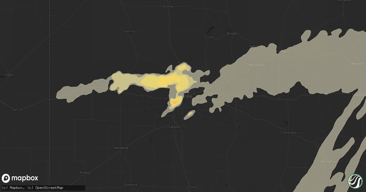
Hail Map in Amarillo, TX on April 28, 2012
Get this storm
April 28 map
$229
one time, instant access
Download today. No call, no setup
Keep the $229
Bought the map and want the full workflow? Apply the entire $229 to a subscription within 7 days. None of it is wasted.
Every map, not just this one
This buys you this map. Subscription and you get every map we run, in the markets you choose from a few cities to whole states to nationwide. Plus real-time alerts the moment a storm fires.
Contact data
Name, contact info, occupancy, even credit band for addresses in the footprint. You go from where it hit to who to call.
Become the source they trust
Unlimited branding weather history reports on demand. You already have the documented answer ready for the property owner, and you are the one who showed up with it.
Property data and RoofTrace estimates
Pull up any address you have got, its value and the exact code rules for that jurisdiction, straight from One Click Code. Then RoofTrace estimates the squares, pitch, and roof value, priced the way you price.
Storm reports in Amarillo, TX
Amarillo, TX
| Date | Description |
|---|---|
| 04/28/20123:55 AM CDT | Quarter to golfball size hail northeast of bishop hills. |
| 04/28/20123:40 AM CDT | Mostly nickel size hail with some larger up to quarters in valley de oro. |
| 04/28/20123:05 AM CDT | Quarter size hail reported on southwest side of amarillo |
| 04/28/20123:00 AM CDT | A local report indicates 1.00 inch wind near 4 WNW AMARILLO |
| 04/28/20122:55 AM CDT | Golf ball size hail reported on southwest side of amarillo |
| 04/28/20122:45 AM CDT | Pea to quarter size hail reported in sleepy hollow subdivision off of coulter street in amarillo. |
| 04/28/20122:10 AM CDT | Quarter size hail near palo duro high school in amarillo. |
| 04/28/20122:02 AM CDT | Quarter size hail reported on polk street in downtown amarillo. |
| 04/28/20122:00 AM CDT | River road area |
All States Impacted by Hail Map on April 28, 2012
All Cities Impacted by Hail Map on April 28, 2012
- French Lick, IN
- Paoli, IN
- Aspermont, TX
- Old Glory, TX
- Medford, OK
- Milltown, IN
- Lawrenceville, IL
- Washington, IN
- Montgomery, IN
- Lanesville, IN
- Floyds Knobs, IN
- Fredericksburg, IN
- Oaktown, IN
- Wheeler, IL
- New Albany, IN
- New Salisbury, IN
- Marengo, IN
- Oblong, IL
- Cannelburg, IN
- Willow Hill, IL
- Flat Rock, IL
- Newton, IL
- Palestine, IL
- Hidalgo, IL
- English, IN
- Stoy, IL
- West Baden Springs, IN
- Ramsey, IN
- Hardinsburg, IN
- Carlisle, IN
- Shoals, IN
- Depauw, IN
- Taswell, IN
- Loogootee, IN
- Robinson, IL
- Louisville, KY
- Georgetown, IN
- Edwardsport, IN
- Shelbyville, KY
- Fisherville, KY
- Bicknell, IN
- Yale, IL
- Plainville, IN
- Dieterich, IL
- Corydon, IN
- Dubois, IN
- Palmyra, IN
- Mount Eden, KY
- Finchville, KY
- Waddy, KY
- Elizabeth, IN
- Bruceville, IN
- Taylorsville, KY
- Greenville, IN
- Crandall, IN
- Wellington, TX
- Shamrock, TX
- Wentzville, MO
- Hazelwood, MO
- Defiance, MO
- Wright City, MO
- Lake Saint Louis, MO
- Moscow Mills, MO
- Brussels, IL
- Warrenton, MO
- Troy, MO
- Old Monroe, MO
- Golden Eagle, IL
- Saint Charles, MO
- O'Fallon, MO
- Saint Peters, MO
- Florissant, MO
- Saint Louis, MO
- Foristell, MO
- Yukon, OK
- Hinton, OK
- Lookeba, OK
- Binger, OK
- Union City, OK
- El Reno, OK
- Minco, OK
- Oklahoma City, OK
- Calumet, OK
- Cleveland, OK
- Adrian, TX
- Vega, TX
- Silex, MO
- Galena, KS
- Amarillo, TX
- Bolivar, MO
- Polk, MO
- Flemington, MO
- Wellsville, MO
- Middletown, MO
- Montgomery City, MO
- Belleville, IL
- Hydro, OK
- Braman, OK
- De Soto, MO
- Festus, MO
- Fletcher, MO
- East Carondelet, IL
- Foley, MO
- Elsberry, MO
- Childress, TX
- Tell, TX
- Quanah, TX
- Memphis, TX
- Mannford, OK
- Jennings, OK
- Prue, OK
- Terlton, OK
- Osage, OK
- Taloga, OK
- Alton, IL
- Litchfield, IL
- Dow, IL
- Mount Olive, IL
- Gillespie, IL
- Godfrey, IL
- Butler, IL
- Hillsboro, IL
- Irving, IL
- Brighton, IL
- Bunker Hill, IL
- Carlinville, IL
- Shipman, IL
- Jerseyville, IL
- Dorsey, IL
- Trenton, IL
- Earth City, MO
- East Saint Louis, IL
- Scott Air Force Base, IL
- Bartelso, IL
- Lovejoy, IL
- New Baden, IL
- Dupo, IL
- Caseyville, IL
- Lebanon, IL
- Albers, IL
- Granite City, IL
- Maryland Heights, MO
- Nashville, IL
- O'Fallon, IL
- Madison, IL
- Aviston, IL
- Troy, IL
- Germantown, IL
- Fairview Heights, IL
- Bridgeton, MO
- Summerfield, IL
- Mascoutah, IL
- Addieville, IL
- Millstadt, IL
- Venice, IL
- Chesterfield, MO
- Collinsville, IL
- Saint Ann, MO
- Okawville, IL
- Liberal, MO
- Mindenmines, MO
- Okarche, OK
- Piedmont, OK
- Tonkawa, OK
- Nardin, OK
- Lamont, OK
- Hunter, OK
- Wellston, OK
- Luther, OK
- Jones, OK
- Blackwell, MO
- Pampa, TX
- Williamsburg, MO
- Centralia, IL
- Hoyleton, IL
- Sentinel, OK
- Carter, OK
- Dill City, OK
- Matador, TX
- Turkey, TX
- Lakeview, TX
- Augusta, MO
- Marthasville, MO
- Briscoe, TX
- Parkersburg, IL
- Girard, TX
- Mobeetie, TX
- Fenton, MO
- Skellytown, TX
- Udall, KS
- Tryon, OK
- Agra, OK
- Meridian, OK
- Carney, OK
- Butler, OK
- Willow, OK
- Elk City, OK
- Granite, OK
- Canute, OK
- Santa Fe, MO
- Stoutsville, MO
- Center, MO
- Perry, MO
- Wheeler, TX
- Panhandle, TX
- Groom, TX
- White Deer, TX
- Mclean, TX
- Borden, IN
- Sellersburg, IN
- Jayton, TX
- Pekin, IN
- Manchester, OK
- Conway Springs, KS
- Bluff City, KS
- Freeport, KS
- Caldwell, KS
- Wakita, OK
- Argonia, KS
- Pond Creek, OK
- Nash, OK
- Milan, KS
- Hollis, OK
- Stillwater, OK
- Corn, OK
- Cushing, OK
- Pittsburg, KS
- Cherokee, KS
- Weir, KS
- Edwardsville, IL
- Raymond, IL
- Staunton, IL
- Worden, IL
- Moro, IL
- Benld, IL
- Cottage Hills, IL
- Bethalto, IL
- Wilsonville, IL
- Medora, IL
- Nokomis, IL
- Witt, IL
- Sawyerville, IL
- East Alton, IL
- Piasa, IL
- Monroe City, IN
- Vincennes, IN
- Wheatland, IN
- Clinton, OK
- Hammon, OK
- Frankford, MO
- New London, MO
- Custer City, OK
- Thomas, OK
- Putnam, OK
- Canadian, TX
- Columbia, MO
- Sayre, OK
- Erick, OK
- Perry, OK
- Waukomis, OK
- Enid, OK
- Nilwood, IL
- Leedey, OK
- Hedley, TX
- Quail, TX
- Marissa, IL
- Lenzburg, IL
- New Athens, IL
- Snyder, TX
- Asbury, MO
- Red Bud, IL
- Baldwin, IL
- Imperial, MO
- Barnhart, MO
- House Springs, MO
- Waterloo, IL
- Valmeyer, IL
- Hillsboro, MO
- Pevely, MO
- Seiling, OK
- Oakwood, OK
- Sulphur, IN
- Winfield, KS
- Oxford, KS
- Geuda Springs, KS
- South Haven, KS
- Douglass, KS
- Rock, KS
- Carlyle, IL
- Breese, IL
- Ramona, OK
- Bartlesville, OK
- Saint Peter, IL
- Farina, IL
- Kinmundy, IL
- Baxter Springs, KS
- Edmond, OK
- Perkins, OK
- Guthrie, OK
- Coyle, OK
- Ripley, OK
- New Florence, MO
- Saint Jacob, IL
- Portage Des Sioux, MO
- Irvington, IL
- Glen Carbon, IL
- Jonesburg, MO
- Maryville, IL
- High Hill, MO
- Truesdale, MO
- Richview, IL
- Freeburg, IL
- Columbia, IL
- Hoffman, IL
- Simpsonville, KY
- Weatherford, OK
- Arapaho, OK
- Owensburg, IN
- Bloomfield, IN
- Pawnee, OK
- Canton, OK
- Watonga, OK
- Fay, OK
- Miami, TX
- Fulton, MO
- Sullivan, MO
- Skiatook, OK
- Belle Plaine, KS
- Blackwell, OK
- Meno, OK
- Drummond, OK
- Lahoma, OK
- Ames, OK
- Xenia, IL
- Hermitage, MO
- Tunas, MO
- Louisburg, MO
- Half Way, MO
- Urbana, MO
- Paducah, TX
- Oswego, KS
- Delaware, OK
- Isabella, OK
- Wildorado, TX
- Sheldon, MO
- Lamar, MO
- Kingdom City, MO
- Lockwood, MO
- Jerico Springs, MO
- Dadeville, MO
- Arcola, MO
- El Dorado Springs, MO
- Stockton, MO
- Geary, OK
- Smithboro, IL
- Mulberry Grove, IL
- Greenville, IL
- Marshall, OK
- Crescent, OK
- New Bloomfield, MO
- Auxvasse, MO
- Ashland, MO
- Kremlin, OK
- Lenapah, OK
- Arkansas City, KS
- Owenton, KY
- Okeene, OK
- Kingfisher, OK
- Hennessey, OK
- Fairview, OK
- Chester, OK
- Spur, TX
- Dickens, TX
- Leon, KS
- Lindsborg, KS
- Assaria, KS
- O'Brien, TX
- Rochester, TX
- Hominy, OK
- Justiceburg, TX
- Pittsburg, MO
- Preston, MO
- Fair Play, MO
- Macks Creek, MO
- Dunnegan, MO
- Centralia, MO
- Bronaugh, MO
- Mangum, OK
- Linton, IN
- Carrollton, MO
- Vandalia, IL
- Shobonier, IL
- Campbellsburg, IN
- Richwoods, MO
- New Douglas, IL
- Sorento, IL
- Orleans, IN
- Rothville, MO
- Milo, MO
- McCune, KS
- Girard, KS
- Frontenac, KS
- Columbus, KS
- Scammon, KS
- Fairfax, OK
- Hartsburg, MO
- California, MO
- Centertown, MO
- Jamestown, MO
- Omega, OK
- Bellflower, MO
- Independence, KS
- Liberty, KS
- Colony, OK
- Cordell, OK
- Arnett, OK
- Loyal, OK
- Lucien, OK
- Cheyenne, OK
- Fairmont, OK
- Durham, OK
- Crawford, OK
- Reydon, OK
- Sweetwater, OK
- Claude, TX
- Covington, OK
- Hitchcock, OK
- Foss, OK
- Bison, OK
- Douglas, OK
- Greenfield, OK
- Gould, OK
- Barnsdall, OK
- Wynona, OK
- Rockbridge, IL
- Hartford, IL
- Highland, IL
- Carrier, OK
- Chandler, OK
- Billings, OK
- Garber, OK
- Inman, KS
- Moundridge, KS
- Galva, KS
- Mcpherson, KS
- Dodson, TX
- Ringwood, OK
- Goltry, OK
- West Alton, MO
- Decker, IN
- Waggoner, IL
- Miami, OK
- Welch, OK
- Bedford, IN
- Tonganoxie, KS
- Bonner Springs, KS
- Kansas City, KS
- Basehor, KS
- Linwood, KS
- Pocahontas, IL
- Vinson, OK
- Drumright, OK
- Arcadia, OK
- Yale, OK
- Spencer, OK
- Maramec, OK
- Louisville, IL
- Flora, IL
- S Coffeyville, OK
- Coffeyville, KS
- High Ridge, MO
- Valley Park, MO
- Eureka, MO
- Abilene, KS
- Golden City, MO
- Greenup, IL
- Casey, IL
- Truxton, MO
- Alba, MO
- Jasper, MO
- Webb City, MO
- Oronogo, MO
- Potosi, MO
- Effingham, IL
- Teutopolis, IL
- Batchtown, IL
- Fieldon, IL
- Hardin, IL
- Odon, IN
- Morrison, OK
- Caney, KS
- Bartlett, KS
- Edna, KS
- Coffeen, IL
- Orlando, OK
- Hallsville, MO
- La Grange, KY
- Crestwood, KY
- Goshen, KY
- Fults, IL
- Edgewood, IL
- Toledo, IL
- Dittmer, MO
- Waverly, IL
- Ramsey, IL
- Ralston, OK
- Paris, MO
- Hawk Point, MO
- Winfield, MO
- Grafton, IL
- Freelandville, IN
- Sandborn, IN
- Sullivan, IN
- Jeffersonville, IN
- Jasper, IN
- Bloomfield, KY
- Elnora, IN
- Salem, IN
- Mount Washington, KY
- Sumner, IL
- Merom, IN
- Petersburg, IN
- Westphalia, IN
- Crane, IN
- Clarksville, IN
- Mitchell, IN
- Lawrenceburg, KY
- Thompson, MO
- Olney, IL
- Noble, IL
- Clay City, IL
- Brownstown, IL
- Alma, IL
- Mason, IL
- Sparta, IL
- Tilden, IL
- Coulterville, IL
- Cedar Hill, MO
- Saint Libory, IL
- Vernon, IL
- Saint Elmo, IL
- Glenview, KY
- Prospect, KY
- Kane, IL
- Vici, OK
- Hereford, TX
- Red Rock, OK
- Dover, OK
- Cee Vee, TX
- Bethany, OK
- Camargo, OK
- Purcell, MO
- Carthage, MO
- Carl Junction, MO
- Joplin, MO
- Pawhuska, OK
- Calhoun, IL
- Ingraham, IL
- Vernon, TX
- Cadet, MO
- Bourbon, MO
- Lyons, IN
- Switz City, IN
- Eldred, IL
- Carrollton, IL
- Louisiana, MO
- Bloomington, IN
- Springville, IN
- Clarksville, MO
- Leasburg, MO
- Crowell, TX
- Shidler, OK
- Cynthiana, KY
- Palmyra, IL
- Modesto, IL
- Mulberry, KS
- Newton, KS
- Sedgwick, KS
- Valley Center, KS
- Chetopa, KS
- Fidelity, IL
- Catawissa, MO
- Elsah, IL
- Smithton, IL
- Portland, MO
- Steedman, MO
- Pacific, MO
- Hamburg, IL
- Ballwin, MO
- Chesterfield, IL
- Charlestown, IN
- Peru, KS
- Portsmouth, OH
- Pedro, OH
- Wheelersburg, OH
- Bedford, KY
- Wooldridge, MO
- Marceline, MO
- Pewee Valley, KY
- Heltonville, IN
- Campbellsburg, KY
- Saint Francisville, IL
- Sedan, KS
- Turners Station, KY
- Worthville, KY
- Sanders, KY
- Hale, MO
- San Jon, NM
- Bard, NM
- Ironton, OH
- Kitts Hill, OH
- Williams, IN
- Fluvanna, TX
- Mendon, MO
- Aldrich, MO
- Roach, MO
- Franklin, KS
- Greenfield, MO
- West Mineral, KS
- Canyon, TX
- Saint Paul, KS
- Lerna, IL
- New Berlin, IL
- Villa Ridge, MO
- Robertsville, MO
- Gypsum, KS
- Vallonia, IN
- Glencoe, OK
- Montrose, IL
- Jewett, IL
- Wakefield, KS
- Alhambra, IL
- Altamont, KS
- Parsons, KS
- Havana, KS
- Hobart, OK
- Nowata, OK


