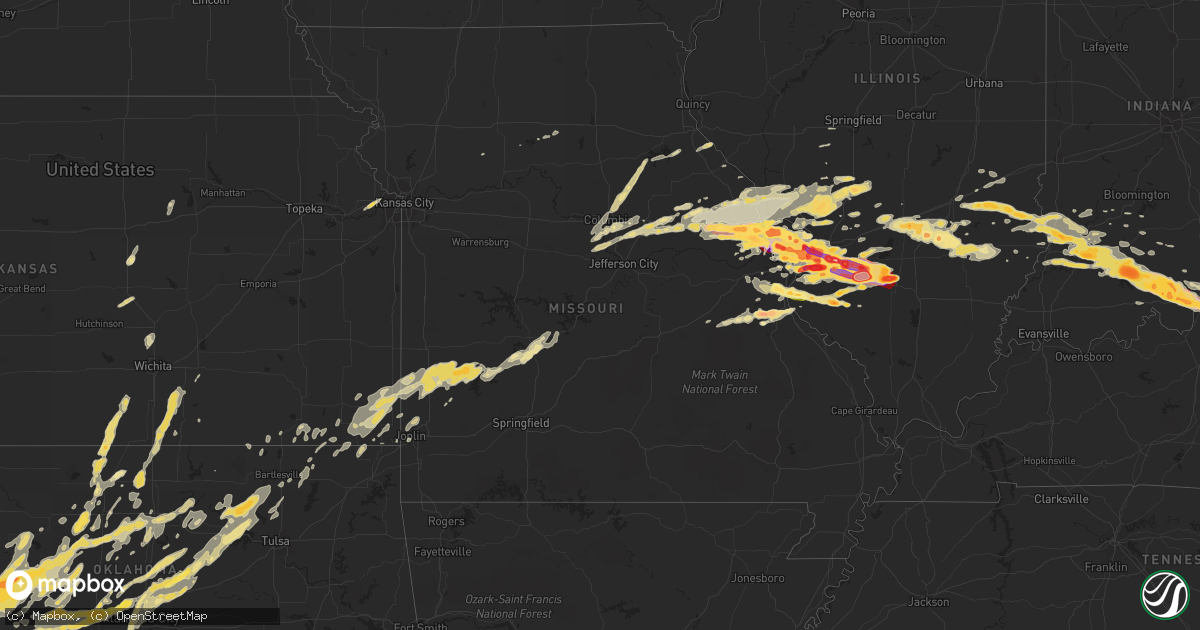
Hail Map in Missouri on April 28, 2012
Get this storm
April 28 map
$229
one time, instant access
Download today. No call, no setup
Keep the $229
Bought the map and want the full workflow? Apply the entire $229 to a subscription within 7 days. None of it is wasted.
Every map, not just this one
This buys you this map. Subscription and you get every map we run, in the markets you choose from a few cities to whole states to nationwide. Plus real-time alerts the moment a storm fires.
Contact data
Name, contact info, occupancy, even credit band for addresses in the footprint. You go from where it hit to who to call.
Become the source they trust
Unlimited branding weather history reports on demand. You already have the documented answer ready for the property owner, and you are the one who showed up with it.
Property data and RoofTrace estimates
Pull up any address you have got, its value and the exact code rules for that jurisdiction, straight from One Click Code. Then RoofTrace estimates the squares, pitch, and roof value, priced the way you price.
Storm reports in Missouri
Missouri
| Date | Description |
|---|---|
| 04/28/20126:33 PM CDT | From the kmov weather camera. |
| 04/28/20126:30 PM CDT | A local report indicates 1.75 inch wind near ST. LOUIS |
| 04/28/20126:29 PM CDT | On north side of town. |
| 04/28/20126:29 PM CDT | Golfball sized hail at tucker and market. |
| 04/28/20126:26 PM CDT | A local report indicates 1.50 inch wind near 3 SE HEMATITE |
| 04/28/20126:24 PM CDT | Large tree was blown over onto an unoccupied car on marquette avenue. |
| 04/28/20126:24 PM CDT | Large tree was uprooted onto a house causing minor roof damage on potomac avenue. |
| 04/28/20126:24 PM CDT | North city. |
| 04/28/20126:24 PM CDT | A large tree was blown over onto a house on pernod avenue...causing moderate damage. |
| 04/28/20126:21 PM CDT | A local report indicates 1.25 inch wind near ST. LOUIS |
| 04/28/20126:20 PM CDT | 15 inch tree snapped near intersection of mackland and southwest avenue. Time approximate from radar. |
| 04/28/20126:20 PM CDT | A local report indicates 2.50 inch wind near OVERLAND |
| 04/28/20126:20 PM CDT | A local report indicates 1.00 inch wind near RICHMOND HEIGHTS |
| 04/28/20126:20 PM CDT | Retired |
| 04/28/20126:20 PM CDT | Near edwards jones dome |
| 04/28/20126:19 PM CDT | Washington university |
| 04/28/20126:19 PM CDT | A local report indicates 1.75 inch wind near OVERLAND |
| 04/28/20126:15 PM CDT | Relayed from public |
| 04/28/20126:15 PM CDT | 1 mile south of i 70 on st. Charles rock road...golfball size hail lasted for 15 minutes |
| 04/28/20126:15 PM CDT | 2.5 ft diamter tree uprooted |
| 04/28/20126:13 PM CDT | A local report indicates 1.50 inch wind near ST. JOHN |
| 04/28/20126:11 PM CDT | Hail covering ground. 55mph wind gusts measured as well. |
| 04/28/20126:11 PM CDT | Two and a half foot diamter tree truck snapped. Time estimated from radar. |
| 04/28/20126:10 PM CDT | A local report indicates 1.75 inch wind near ST. ANN |
| 04/28/20126:10 PM CDT | A local report indicates 1.75 inch wind near OVERLAND |
| 04/28/20126:10 PM CDT | A local report indicates 1.50 inch wind near OLIVETTE |
| 04/28/20126:09 PM CDT | A local report indicates 2.00 inch wind near MARYLAND HEIGHTS |
| 04/28/20126:08 PM CDT | A local report indicates 1.75 inch wind near ST. ANN |
| 04/28/20126:07 PM CDT | Severall vehicles in the area with broken windows. |
| 04/28/20126:07 PM CDT | A local report indicates 1.50 inch wind near MARYLAND HEIGHTS |
| 04/28/20126:06 PM CDT | A local report indicates 1.25 inch wind near 2 SSE BRIDGETON |
| 04/28/20126:05 PM CDT | A local report indicates 1.75 inch wind near OVERLAND |
| 04/28/20126:05 PM CDT | A local report indicates 1.50 inch wind near 1 NW CREVE COEUR |
| 04/28/20126:05 PM CDT | A local report indicates 1.75 inch wind near DE SOTO |
| 04/28/20126:03 PM CDT | A local report indicates 1.75 inch wind near CREVE COEUR |
| 04/28/20126:02 PM CDT | A local report indicates 1.00 inch wind near BRIDGETON |
| 04/28/20126:01 PM CDT | West side of town. |
| 04/28/20126:00 PM CDT | A local report indicates 2.00 inch wind near CREVE COEUR |
| 04/28/20125:59 PM CDT | Near 364 and upper bottom rd |
| 04/28/20125:57 PM CDT | Near i 70 and 5th street |
| 04/28/20125:50 PM CDT | At intersection of kimberly and st. Peters howell. |
| 04/28/20125:50 PM CDT | A local report indicates 1.75 inch wind near ST. PAUL |
| 04/28/20125:48 PM CDT | Relayed from the public |
| 04/28/20125:45 PM CDT | A local report indicates 2.00 inch wind near 2 NW O'FALLON |
| 04/28/20125:42 PM CDT | A local report indicates 1.75 inch wind near ST. PAUL |
| 04/28/20125:41 PM CDT | A local report indicates 3.00 inch wind near WENTZVILLE |
| 04/28/20125:39 PM CDT | South side of town. |
| 04/28/20125:35 PM CDT | A local report indicates 2.75 inch wind near FLINT HILL |
| 04/28/20125:34 PM CDT | A local report indicates 1.75 inch wind near WENTZVILLE |
| 04/28/20125:33 PM CDT | Plywood and other small pieces of debris on westbound lanes of interstate 70 between mile markers 212 and 213. |
| 04/28/20125:30 PM CDT | A local report indicates 1.75 inch wind near 2 W WENTZVILLE |
| 04/28/20125:28 PM CDT | A local report indicates 2.75 inch wind near WENTZVILLE |
| 04/28/20125:20 PM CDT | A local report indicates 1.75 inch wind near 2 N WRIGHT CITY |
| 04/28/20125:17 PM CDT | Hail covering ground. |
| 04/28/20125:08 PM CDT | A local report indicates 1.25 inch wind near 2 N WARRENTON |
| 04/28/20124:30 PM CDT | Just north of intersection of hwy j and ww |
| 04/28/20123:44 PM CDT | Has lasted over 5 minutes |
| 04/28/20123:42 PM CDT | A local report indicates 1.25 inch wind near FERGUSON |
| 04/28/20123:35 PM CDT | A local report indicates 1.75 inch wind near FLORISSANT |
| 04/28/20123:28 PM CDT | Near intersection of charbonier and shackelford |
| 04/28/20123:28 PM CDT | A local report indicates 1.75 inch wind near HAZELWOOD |
| 04/28/20123:27 PM CDT | Reported at lambert airport |
| 04/28/20123:26 PM CDT | A local report indicates 2.00 inch wind near 1 N HAZELWOOD |
| 04/28/20123:25 PM CDT | Two trees snapped at the base with 1 ft trunk diameter |
| 04/28/20123:25 PM CDT | A local report indicates 1.25 inch wind near FLORISSANT |
| 04/28/20123:25 PM CDT | 3 miles west of lambert |
| 04/28/20123:25 PM CDT | Several reports of golfball size hail in hazelwood |
| 04/28/20123:24 PM CDT | A local report indicates 1.00 inch wind near 1 N HAZELWOOD |
| 04/28/20123:23 PM CDT | A local report indicates 1.75 inch wind near 2 NW FLORISSANT |
| 04/28/20123:15 PM CDT | A local report indicates 1.50 inch wind near 2 N ST. CHARLES |
| 04/28/20123:14 PM CDT | Near intersection of elm and hunters ridge |
| 04/28/20122:40 PM CDT | 2 miles north of interstate 70 on us hwy 61 |
| 04/28/20122:39 PM CDT | A local report indicates 1.00 inch wind near 3 NW WENTZVILLE |
| 04/28/20122:30 PM CDT | A local report indicates 1.00 inch wind near 4 N WRIGHT CITY |
| 04/28/20121:18 PM CDT | A local report indicates 1.00 inch wind near 3 E FULTON |
| 04/28/20122:45 AM CDT | A local report indicates 1.00 inch wind near CENTRALIA |
| 04/28/20122:25 AM CDT | A local report indicates 1.00 inch wind near 3 NE HALLSVILLE |
| 04/27/20128:53 PM CDT | A local report indicates 1.25 inch wind near VALLES MILL |
| 04/27/20128:36 PM CDT | A local report indicates 1.50 inch wind near BARNHART |
| 04/27/20128:25 PM CDT | A local report indicates 1.00 inch wind near OTTO |
All States Impacted by Hail Map on April 28, 2012
Cities Impacted by Hail Map on April 28, 2012
- French Lick, IN
- Paoli, IN
- Aspermont, TX
- Old Glory, TX
- Medford, OK
- Milltown, IN
- Lawrenceville, IL
- Washington, IN
- Montgomery, IN
- Lanesville, IN
- Floyds Knobs, IN
- Fredericksburg, IN
- Oaktown, IN
- Wheeler, IL
- New Albany, IN
- New Salisbury, IN
- Marengo, IN
- Oblong, IL
- Cannelburg, IN
- Willow Hill, IL
- Flat Rock, IL
- Newton, IL
- Palestine, IL
- Hidalgo, IL
- English, IN
- Stoy, IL
- West Baden Springs, IN
- Ramsey, IN
- Hardinsburg, IN
- Carlisle, IN
- Shoals, IN
- Depauw, IN
- Taswell, IN
- Loogootee, IN
- Robinson, IL
- Louisville, KY
- Georgetown, IN
- Edwardsport, IN
- Shelbyville, KY
- Fisherville, KY
- Bicknell, IN
- Yale, IL
- Plainville, IN
- Dieterich, IL
- Corydon, IN
- Dubois, IN
- Palmyra, IN
- Mount Eden, KY
- Finchville, KY
- Waddy, KY
- Elizabeth, IN
- Bruceville, IN
- Taylorsville, KY
- Greenville, IN
- Crandall, IN
- Wellington, TX
- Shamrock, TX
- Wentzville, MO
- Hazelwood, MO
- Defiance, MO
- Wright City, MO
- Lake Saint Louis, MO
- Moscow Mills, MO
- Brussels, IL
- Warrenton, MO
- Troy, MO
- Old Monroe, MO
- Golden Eagle, IL
- Saint Charles, MO
- O'Fallon, MO
- Saint Peters, MO
- Florissant, MO
- Saint Louis, MO
- Foristell, MO
- Yukon, OK
- Hinton, OK
- Lookeba, OK
- Binger, OK
- Union City, OK
- El Reno, OK
- Minco, OK
- Oklahoma City, OK
- Calumet, OK
- Cleveland, OK
- Adrian, TX
- Vega, TX
- Silex, MO
- Galena, KS
- Amarillo, TX
- Bolivar, MO
- Polk, MO
- Flemington, MO
- Wellsville, MO
- Middletown, MO
- Montgomery City, MO
- Belleville, IL
- Hydro, OK
- Braman, OK
- De Soto, MO
- Festus, MO
- Fletcher, MO
- East Carondelet, IL
- Foley, MO
- Elsberry, MO
- Childress, TX
- Tell, TX
- Quanah, TX
- Memphis, TX
- Mannford, OK
- Jennings, OK
- Prue, OK
- Terlton, OK
- Osage, OK
- Taloga, OK
- Alton, IL
- Litchfield, IL
- Dow, IL
- Mount Olive, IL
- Gillespie, IL
- Godfrey, IL
- Butler, IL
- Hillsboro, IL
- Irving, IL
- Brighton, IL
- Bunker Hill, IL
- Carlinville, IL
- Shipman, IL
- Jerseyville, IL
- Dorsey, IL
- Trenton, IL
- Earth City, MO
- East Saint Louis, IL
- Scott Air Force Base, IL
- Bartelso, IL
- Lovejoy, IL
- New Baden, IL
- Dupo, IL
- Caseyville, IL
- Lebanon, IL
- Albers, IL
- Granite City, IL
- Maryland Heights, MO
- Nashville, IL
- O'Fallon, IL
- Madison, IL
- Aviston, IL
- Troy, IL
- Germantown, IL
- Fairview Heights, IL
- Bridgeton, MO
- Summerfield, IL
- Mascoutah, IL
- Addieville, IL
- Millstadt, IL
- Venice, IL
- Chesterfield, MO
- Collinsville, IL
- Saint Ann, MO
- Okawville, IL
- Liberal, MO
- Mindenmines, MO
- Okarche, OK
- Piedmont, OK
- Tonkawa, OK
- Nardin, OK
- Lamont, OK
- Hunter, OK
- Wellston, OK
- Luther, OK
- Jones, OK
- Blackwell, MO
- Pampa, TX
- Williamsburg, MO
- Centralia, IL
- Hoyleton, IL
- Sentinel, OK
- Carter, OK
- Dill City, OK
- Matador, TX
- Turkey, TX
- Lakeview, TX
- Augusta, MO
- Marthasville, MO
- Briscoe, TX
- Parkersburg, IL
- Girard, TX
- Mobeetie, TX
- Fenton, MO
- Skellytown, TX
- Udall, KS
- Tryon, OK
- Agra, OK
- Meridian, OK
- Carney, OK
- Butler, OK
- Willow, OK
- Elk City, OK
- Granite, OK
- Canute, OK
- Santa Fe, MO
- Stoutsville, MO
- Center, MO
- Perry, MO
- Wheeler, TX
- Panhandle, TX
- Groom, TX
- White Deer, TX
- Mclean, TX
- Borden, IN
- Sellersburg, IN
- Jayton, TX
- Pekin, IN
- Manchester, OK
- Conway Springs, KS
- Bluff City, KS
- Freeport, KS
- Caldwell, KS
- Wakita, OK
- Argonia, KS
- Pond Creek, OK
- Nash, OK
- Milan, KS
- Hollis, OK
- Stillwater, OK
- Corn, OK
- Cushing, OK
- Pittsburg, KS
- Cherokee, KS
- Weir, KS
- Edwardsville, IL
- Raymond, IL
- Staunton, IL
- Worden, IL
- Moro, IL
- Benld, IL
- Cottage Hills, IL
- Bethalto, IL
- Wilsonville, IL
- Medora, IL
- Nokomis, IL
- Witt, IL
- Sawyerville, IL
- East Alton, IL
- Piasa, IL
- Monroe City, IN
- Vincennes, IN
- Wheatland, IN
- Clinton, OK
- Hammon, OK
- Frankford, MO
- New London, MO
- Custer City, OK
- Thomas, OK
- Putnam, OK
- Canadian, TX
- Columbia, MO
- Sayre, OK
- Erick, OK
- Perry, OK
- Waukomis, OK
- Enid, OK
- Nilwood, IL
- Leedey, OK
- Hedley, TX
- Quail, TX
- Marissa, IL
- Lenzburg, IL
- New Athens, IL
- Snyder, TX
- Asbury, MO
- Red Bud, IL
- Baldwin, IL
- Imperial, MO
- Barnhart, MO
- House Springs, MO
- Waterloo, IL
- Valmeyer, IL
- Hillsboro, MO
- Pevely, MO
- Seiling, OK
- Oakwood, OK
- Sulphur, IN
- Winfield, KS
- Oxford, KS
- Geuda Springs, KS
- South Haven, KS
- Douglass, KS
- Rock, KS
- Carlyle, IL
- Breese, IL
- Ramona, OK
- Bartlesville, OK
- Saint Peter, IL
- Farina, IL
- Kinmundy, IL
- Baxter Springs, KS
- Edmond, OK
- Perkins, OK
- Guthrie, OK
- Coyle, OK
- Ripley, OK
- New Florence, MO
- Saint Jacob, IL
- Portage Des Sioux, MO
- Irvington, IL
- Glen Carbon, IL
- Jonesburg, MO
- Maryville, IL
- High Hill, MO
- Truesdale, MO
- Richview, IL
- Freeburg, IL
- Columbia, IL
- Hoffman, IL
- Simpsonville, KY
- Weatherford, OK
- Arapaho, OK
- Owensburg, IN
- Bloomfield, IN
- Pawnee, OK
- Canton, OK
- Watonga, OK
- Fay, OK
- Miami, TX
- Fulton, MO
- Sullivan, MO
- Skiatook, OK
- Belle Plaine, KS
- Blackwell, OK
- Meno, OK
- Drummond, OK
- Lahoma, OK
- Ames, OK
- Xenia, IL
- Hermitage, MO
- Tunas, MO
- Louisburg, MO
- Half Way, MO
- Urbana, MO
- Paducah, TX
- Oswego, KS
- Delaware, OK
- Isabella, OK
- Wildorado, TX
- Sheldon, MO
- Lamar, MO
- Kingdom City, MO
- Lockwood, MO
- Jerico Springs, MO
- Dadeville, MO
- Arcola, MO
- El Dorado Springs, MO
- Stockton, MO
- Geary, OK
- Smithboro, IL
- Mulberry Grove, IL
- Greenville, IL
- Marshall, OK
- Crescent, OK
- New Bloomfield, MO
- Auxvasse, MO
- Ashland, MO
- Kremlin, OK
- Lenapah, OK
- Arkansas City, KS
- Owenton, KY
- Okeene, OK
- Kingfisher, OK
- Hennessey, OK
- Fairview, OK
- Chester, OK
- Spur, TX
- Dickens, TX
- Leon, KS
- Lindsborg, KS
- Assaria, KS
- O'Brien, TX
- Rochester, TX
- Hominy, OK
- Justiceburg, TX
- Pittsburg, MO
- Preston, MO
- Fair Play, MO
- Macks Creek, MO
- Dunnegan, MO
- Centralia, MO
- Bronaugh, MO
- Mangum, OK
- Linton, IN
- Carrollton, MO
- Vandalia, IL
- Shobonier, IL
- Campbellsburg, IN
- Richwoods, MO
- New Douglas, IL
- Sorento, IL
- Orleans, IN
- Rothville, MO
- Milo, MO
- McCune, KS
- Girard, KS
- Frontenac, KS
- Columbus, KS
- Scammon, KS
- Fairfax, OK
- Hartsburg, MO
- California, MO
- Centertown, MO
- Jamestown, MO
- Omega, OK
- Bellflower, MO
- Independence, KS
- Liberty, KS
- Colony, OK
- Cordell, OK
- Arnett, OK
- Loyal, OK
- Lucien, OK
- Cheyenne, OK
- Fairmont, OK
- Durham, OK
- Crawford, OK
- Reydon, OK
- Sweetwater, OK
- Claude, TX
- Covington, OK
- Hitchcock, OK
- Foss, OK
- Bison, OK
- Douglas, OK
- Greenfield, OK
- Gould, OK
- Barnsdall, OK
- Wynona, OK
- Rockbridge, IL
- Hartford, IL
- Highland, IL
- Carrier, OK
- Chandler, OK
- Billings, OK
- Garber, OK
- Inman, KS
- Moundridge, KS
- Galva, KS
- Mcpherson, KS
- Dodson, TX
- Ringwood, OK
- Goltry, OK
- West Alton, MO
- Decker, IN
- Waggoner, IL
- Miami, OK
- Welch, OK
- Bedford, IN
- Tonganoxie, KS
- Bonner Springs, KS
- Kansas City, KS
- Basehor, KS
- Linwood, KS
- Pocahontas, IL
- Vinson, OK
- Drumright, OK
- Arcadia, OK
- Yale, OK
- Spencer, OK
- Maramec, OK
- Louisville, IL
- Flora, IL
- S Coffeyville, OK
- Coffeyville, KS
- High Ridge, MO
- Valley Park, MO
- Eureka, MO
- Abilene, KS
- Golden City, MO
- Greenup, IL
- Casey, IL
- Truxton, MO
- Alba, MO
- Jasper, MO
- Webb City, MO
- Oronogo, MO
- Potosi, MO
- Effingham, IL
- Teutopolis, IL
- Batchtown, IL
- Fieldon, IL
- Hardin, IL
- Odon, IN
- Morrison, OK
- Caney, KS
- Bartlett, KS
- Edna, KS
- Coffeen, IL
- Orlando, OK
- Hallsville, MO
- La Grange, KY
- Crestwood, KY
- Goshen, KY
- Fults, IL
- Edgewood, IL
- Toledo, IL
- Dittmer, MO
- Waverly, IL
- Ramsey, IL
- Ralston, OK
- Paris, MO
- Hawk Point, MO
- Winfield, MO
- Grafton, IL
- Freelandville, IN
- Sandborn, IN
- Sullivan, IN
- Jeffersonville, IN
- Jasper, IN
- Bloomfield, KY
- Elnora, IN
- Salem, IN
- Mount Washington, KY
- Sumner, IL
- Merom, IN
- Petersburg, IN
- Westphalia, IN
- Crane, IN
- Clarksville, IN
- Mitchell, IN
- Lawrenceburg, KY
- Thompson, MO
- Olney, IL
- Noble, IL
- Clay City, IL
- Brownstown, IL
- Alma, IL
- Mason, IL
- Sparta, IL
- Tilden, IL
- Coulterville, IL
- Cedar Hill, MO
- Saint Libory, IL
- Vernon, IL
- Saint Elmo, IL
- Glenview, KY
- Prospect, KY
- Kane, IL
- Vici, OK
- Hereford, TX
- Red Rock, OK
- Dover, OK
- Cee Vee, TX
- Bethany, OK
- Camargo, OK
- Purcell, MO
- Carthage, MO
- Carl Junction, MO
- Joplin, MO
- Pawhuska, OK
- Calhoun, IL
- Ingraham, IL
- Vernon, TX
- Cadet, MO
- Bourbon, MO
- Lyons, IN
- Switz City, IN
- Eldred, IL
- Carrollton, IL
- Louisiana, MO
- Bloomington, IN
- Springville, IN
- Clarksville, MO
- Leasburg, MO
- Crowell, TX
- Shidler, OK
- Cynthiana, KY
- Palmyra, IL
- Modesto, IL
- Mulberry, KS
- Newton, KS
- Sedgwick, KS
- Valley Center, KS
- Chetopa, KS
- Fidelity, IL
- Catawissa, MO
- Elsah, IL
- Smithton, IL
- Portland, MO
- Steedman, MO
- Pacific, MO
- Hamburg, IL
- Ballwin, MO
- Chesterfield, IL
- Charlestown, IN
- Peru, KS
- Portsmouth, OH
- Pedro, OH
- Wheelersburg, OH
- Bedford, KY
- Wooldridge, MO
- Marceline, MO
- Pewee Valley, KY
- Heltonville, IN
- Campbellsburg, KY
- Saint Francisville, IL
- Sedan, KS
- Turners Station, KY
- Worthville, KY
- Sanders, KY
- Hale, MO
- San Jon, NM
- Bard, NM
- Ironton, OH
- Kitts Hill, OH
- Williams, IN
- Fluvanna, TX
- Mendon, MO
- Aldrich, MO
- Roach, MO
- Franklin, KS
- Greenfield, MO
- West Mineral, KS
- Canyon, TX
- Saint Paul, KS
- Lerna, IL
- New Berlin, IL
- Villa Ridge, MO
- Robertsville, MO
- Gypsum, KS
- Vallonia, IN
- Glencoe, OK
- Montrose, IL
- Jewett, IL
- Wakefield, KS
- Alhambra, IL
- Altamont, KS
- Parsons, KS
- Havana, KS
- Hobart, OK
- Nowata, OK


