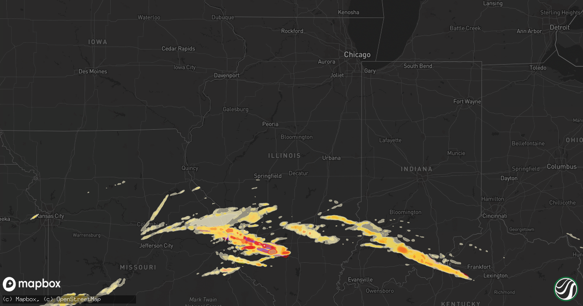
Hail Map in Illinois on April 28, 2012
Get this storm
April 28 map
$229
one time, instant access
Download today. No call, no setup
Keep the $229
Bought the map and want the full workflow? Apply the entire $229 to a subscription within 7 days. None of it is wasted.
Every map, not just this one
This buys you this map. Subscription and you get every map we run, in the markets you choose from a few cities to whole states to nationwide. Plus real-time alerts the moment a storm fires.
Contact data
Name, contact info, occupancy, even credit band for addresses in the footprint. You go from where it hit to who to call.
Become the source they trust
Unlimited branding weather history reports on demand. You already have the documented answer ready for the property owner, and you are the one who showed up with it.
Property data and RoofTrace estimates
Pull up any address you have got, its value and the exact code rules for that jurisdiction, straight from One Click Code. Then RoofTrace estimates the squares, pitch, and roof value, priced the way you price.
Storm reports in Illinois
Illinois
| Date | Description |
|---|---|
| 04/28/20126:55 PM CDT | A local report indicates 1.00 inch wind near ST. PETER |
| 04/28/20126:50 PM CDT | Power lines and large limbs blown down. |
| 04/28/20126:07 PM CDT | A local report indicates 1.00 inch wind near OKAWVILLE |
| 04/28/20126:03 PM CDT | A local report indicates 1.75 inch wind near VENEDY |
| 04/28/20125:57 PM CDT | A local report indicates 2.75 inch wind near HOYLETON |
| 04/28/20125:55 PM CDT | A local report indicates 1.75 inch wind near 3 N VENEDY |
| 04/28/20125:50 PM CDT | A local report indicates 1.75 inch wind near ST. PAUL |
| 04/28/20125:38 PM CDT | A local report indicates 1.00 inch wind near NEW MINDEN |
| 04/28/20125:37 PM CDT | A local report indicates 1.00 inch wind near COVINGTON |
| 04/28/20125:20 PM CDT | Corrected for time |
| 04/28/20124:51 PM CDT | Started 15 minutes ago. Now ended. Car windshields broken. |
| 04/28/20124:50 PM CDT | A local report indicates 1.00 inch wind near NEW BADEN |
| 04/28/20124:50 PM CDT | A local report indicates 1.50 inch wind near MASCOUTAH |
| 04/28/20124:50 PM CDT | A local report indicates 2.00 inch wind near GERMANTOWN |
| 04/28/20124:46 PM CDT | A local report indicates 1.75 inch wind near MASCOUTAH |
| 04/28/20124:40 PM CDT | A local report indicates 1.75 inch wind near MASCOUTAH |
| 04/28/20124:40 PM CDT | A local report indicates 1.75 inch wind near AVISTON |
| 04/28/20124:33 PM CDT | On west side of town. |
| 04/28/20124:30 PM CDT | On i 64 near new baden road...three vehicles had back window shattered |
| 04/28/20124:30 PM CDT | Just ended |
| 04/28/20124:30 PM CDT | Several large metal road signs blown down between ofallon and the county line along i 64...also a few large trees were snapped across the southeast portion of ofallon j |
| 04/28/20124:30 PM CDT | Covering the ground |
| 04/28/20124:30 PM CDT | Damage to motor vehicles. |
| 04/28/20124:29 PM CDT | A local report indicates 1.00 inch wind near SWANSEA |
| 04/28/20124:28 PM CDT | East part of belleville |
| 04/28/20124:27 PM CDT | At scott afb |
| 04/28/20124:26 PM CDT | A local report indicates 1.75 inch wind near BELLEVILLE |
| 04/28/20124:25 PM CDT | Western part of belleville |
| 04/28/20124:22 PM CDT | Hail damaged numerous car windshields and home windows as well. |
| 04/28/20124:20 PM CDT | A local report indicates 4.50 inch wind near OKAWVILLE |
| 04/28/20124:20 PM CDT | 8 to 10 inch limbs down |
| 04/28/20124:20 PM CDT | A local report indicates 2.50 inch wind near 2 S LEBANON |
| 04/28/20124:19 PM CDT | A local report indicates 2.50 inch wind near O'FALLON |
| 04/28/20124:19 PM CDT | A local report indicates 1.75 inch wind near SCOTT AFB |
| 04/28/20124:17 PM CDT | A local report indicates 1.75 inch wind near CAHOKIA |
| 04/28/20124:15 PM CDT | Covering the ground 3 inches deep |
| 04/28/20124:15 PM CDT | A local report indicates 1.50 inch wind near ROBINSON |
| 04/28/20124:15 PM CDT | Wind est 50 mph...small tree branches down |
| 04/28/20124:14 PM CDT | A local report indicates 2.00 inch wind near FAIRVIEW HEIGHTS |
| 04/28/20124:12 PM CDT | A local report indicates 2.50 inch wind near O'FALLON |
| 04/28/20124:10 PM CDT | Est 60 to 70 mph winds...near green mount rd and i 64 |
| 04/28/20124:05 PM CDT | A local report indicates 2.20 inch wind near FAIRVIEW HEIGHTS |
| 04/28/20124:03 PM CDT | Leaves shredded from trees. Damaged roof shingles. Dents on cars. |
| 04/28/20124:00 PM CDT | A local report indicates 1.50 inch wind near OBLONG |
| 04/28/20123:59 PM CDT | A local report indicates 2.50 inch wind near COLLINSVILLE |
| 04/28/20123:59 PM CDT | At cahokia mounds |
| 04/28/20123:58 PM CDT | A local report indicates 1.00 inch wind near COLLINSVILLE |
| 04/28/20123:57 PM CDT | A local report indicates 1.00 inch wind near COLLINSVILLE |
| 04/28/20123:53 PM CDT | Ground is covered in hail |
| 04/28/20123:50 PM CDT | A local report indicates 2.50 inch wind near GRANITE CITY |
| 04/28/20123:48 PM CDT | A local report indicates 60 MPH wind near GRANITE CITY |
| 04/28/20123:43 PM CDT | A local report indicates 1.00 inch wind near GRANITE CITY |
| 04/28/20123:41 PM CDT | A local report indicates 1.50 inch wind near 4 S ROSE HILL |
| 04/28/20123:35 PM CDT | A local report indicates 1.00 inch wind near 4 S ROSE HILL |
| 04/27/201210:29 PM CDT | Hail covering ground. |
| 04/27/201210:00 PM CDT | 1 inch to 1.75 inch hail |
| 04/27/20129:39 PM CDT | Hail covering ground on south side of town. |
| 04/27/20129:35 PM CDT | A local report indicates 2.00 inch wind near 1 SSW MARISSA |
| 04/27/20129:01 PM CDT | At intersection of illinois route 3 and kaskaskia road. |
| 04/27/20129:00 PM CDT | Two small buildings had their roofs blown off. A couple trees blow over. |
| 04/27/20128:53 PM CDT | A local report indicates 1.25 inch wind near VALMEYER |
| 04/27/20127:56 PM CDT | A local report indicates 1.00 inch wind near CLAY CITY |
| 04/27/20127:20 PM CDT | A local report indicates 1.75 inch wind near IOLA |
| 04/27/20127:20 PM CDT | A local report indicates 1.75 inch wind near 1 E LOUISVILLE |
| 04/27/20127:18 PM CDT | A local report indicates 1.50 inch wind near IOLA |
| 04/27/20127:18 PM CDT | A local report indicates 1.50 inch wind near 1 E LOUISVILLE |
| 04/27/20127:07 PM CDT | At albers exit on i 64 |
| 04/27/20127:03 PM CDT | Enough hail that it looks like it snowed and very dense fog has now developed |
| 04/27/20127:03 PM CDT | Measured by a state trooper |
All States Impacted by Hail Map on April 28, 2012
Cities Impacted by Hail Map on April 28, 2012
- French Lick, IN
- Paoli, IN
- Aspermont, TX
- Old Glory, TX
- Medford, OK
- Milltown, IN
- Lawrenceville, IL
- Washington, IN
- Montgomery, IN
- Lanesville, IN
- Floyds Knobs, IN
- Fredericksburg, IN
- Oaktown, IN
- Wheeler, IL
- New Albany, IN
- New Salisbury, IN
- Marengo, IN
- Oblong, IL
- Cannelburg, IN
- Willow Hill, IL
- Flat Rock, IL
- Newton, IL
- Palestine, IL
- Hidalgo, IL
- English, IN
- Stoy, IL
- West Baden Springs, IN
- Ramsey, IN
- Hardinsburg, IN
- Carlisle, IN
- Shoals, IN
- Depauw, IN
- Taswell, IN
- Loogootee, IN
- Robinson, IL
- Louisville, KY
- Georgetown, IN
- Edwardsport, IN
- Shelbyville, KY
- Fisherville, KY
- Bicknell, IN
- Yale, IL
- Plainville, IN
- Dieterich, IL
- Corydon, IN
- Dubois, IN
- Palmyra, IN
- Mount Eden, KY
- Finchville, KY
- Waddy, KY
- Elizabeth, IN
- Bruceville, IN
- Taylorsville, KY
- Greenville, IN
- Crandall, IN
- Wellington, TX
- Shamrock, TX
- Wentzville, MO
- Hazelwood, MO
- Defiance, MO
- Wright City, MO
- Lake Saint Louis, MO
- Moscow Mills, MO
- Brussels, IL
- Warrenton, MO
- Troy, MO
- Old Monroe, MO
- Golden Eagle, IL
- Saint Charles, MO
- O'Fallon, MO
- Saint Peters, MO
- Florissant, MO
- Saint Louis, MO
- Foristell, MO
- Yukon, OK
- Hinton, OK
- Lookeba, OK
- Binger, OK
- Union City, OK
- El Reno, OK
- Minco, OK
- Oklahoma City, OK
- Calumet, OK
- Cleveland, OK
- Adrian, TX
- Vega, TX
- Silex, MO
- Galena, KS
- Amarillo, TX
- Bolivar, MO
- Polk, MO
- Flemington, MO
- Wellsville, MO
- Middletown, MO
- Montgomery City, MO
- Belleville, IL
- Hydro, OK
- Braman, OK
- De Soto, MO
- Festus, MO
- Fletcher, MO
- East Carondelet, IL
- Foley, MO
- Elsberry, MO
- Childress, TX
- Tell, TX
- Quanah, TX
- Memphis, TX
- Mannford, OK
- Jennings, OK
- Prue, OK
- Terlton, OK
- Osage, OK
- Taloga, OK
- Alton, IL
- Litchfield, IL
- Dow, IL
- Mount Olive, IL
- Gillespie, IL
- Godfrey, IL
- Butler, IL
- Hillsboro, IL
- Irving, IL
- Brighton, IL
- Bunker Hill, IL
- Carlinville, IL
- Shipman, IL
- Jerseyville, IL
- Dorsey, IL
- Trenton, IL
- Earth City, MO
- East Saint Louis, IL
- Scott Air Force Base, IL
- Bartelso, IL
- Lovejoy, IL
- New Baden, IL
- Dupo, IL
- Caseyville, IL
- Lebanon, IL
- Albers, IL
- Granite City, IL
- Maryland Heights, MO
- Nashville, IL
- O'Fallon, IL
- Madison, IL
- Aviston, IL
- Troy, IL
- Germantown, IL
- Fairview Heights, IL
- Bridgeton, MO
- Summerfield, IL
- Mascoutah, IL
- Addieville, IL
- Millstadt, IL
- Venice, IL
- Chesterfield, MO
- Collinsville, IL
- Saint Ann, MO
- Okawville, IL
- Liberal, MO
- Mindenmines, MO
- Okarche, OK
- Piedmont, OK
- Tonkawa, OK
- Nardin, OK
- Lamont, OK
- Hunter, OK
- Wellston, OK
- Luther, OK
- Jones, OK
- Blackwell, MO
- Pampa, TX
- Williamsburg, MO
- Centralia, IL
- Hoyleton, IL
- Sentinel, OK
- Carter, OK
- Dill City, OK
- Matador, TX
- Turkey, TX
- Lakeview, TX
- Augusta, MO
- Marthasville, MO
- Briscoe, TX
- Parkersburg, IL
- Girard, TX
- Mobeetie, TX
- Fenton, MO
- Skellytown, TX
- Udall, KS
- Tryon, OK
- Agra, OK
- Meridian, OK
- Carney, OK
- Butler, OK
- Willow, OK
- Elk City, OK
- Granite, OK
- Canute, OK
- Santa Fe, MO
- Stoutsville, MO
- Center, MO
- Perry, MO
- Wheeler, TX
- Panhandle, TX
- Groom, TX
- White Deer, TX
- Mclean, TX
- Borden, IN
- Sellersburg, IN
- Jayton, TX
- Pekin, IN
- Manchester, OK
- Conway Springs, KS
- Bluff City, KS
- Freeport, KS
- Caldwell, KS
- Wakita, OK
- Argonia, KS
- Pond Creek, OK
- Nash, OK
- Milan, KS
- Hollis, OK
- Stillwater, OK
- Corn, OK
- Cushing, OK
- Pittsburg, KS
- Cherokee, KS
- Weir, KS
- Edwardsville, IL
- Raymond, IL
- Staunton, IL
- Worden, IL
- Moro, IL
- Benld, IL
- Cottage Hills, IL
- Bethalto, IL
- Wilsonville, IL
- Medora, IL
- Nokomis, IL
- Witt, IL
- Sawyerville, IL
- East Alton, IL
- Piasa, IL
- Monroe City, IN
- Vincennes, IN
- Wheatland, IN
- Clinton, OK
- Hammon, OK
- Frankford, MO
- New London, MO
- Custer City, OK
- Thomas, OK
- Putnam, OK
- Canadian, TX
- Columbia, MO
- Sayre, OK
- Erick, OK
- Perry, OK
- Waukomis, OK
- Enid, OK
- Nilwood, IL
- Leedey, OK
- Hedley, TX
- Quail, TX
- Marissa, IL
- Lenzburg, IL
- New Athens, IL
- Snyder, TX
- Asbury, MO
- Red Bud, IL
- Baldwin, IL
- Imperial, MO
- Barnhart, MO
- House Springs, MO
- Waterloo, IL
- Valmeyer, IL
- Hillsboro, MO
- Pevely, MO
- Seiling, OK
- Oakwood, OK
- Sulphur, IN
- Winfield, KS
- Oxford, KS
- Geuda Springs, KS
- South Haven, KS
- Douglass, KS
- Rock, KS
- Carlyle, IL
- Breese, IL
- Ramona, OK
- Bartlesville, OK
- Saint Peter, IL
- Farina, IL
- Kinmundy, IL
- Baxter Springs, KS
- Edmond, OK
- Perkins, OK
- Guthrie, OK
- Coyle, OK
- Ripley, OK
- New Florence, MO
- Saint Jacob, IL
- Portage Des Sioux, MO
- Irvington, IL
- Glen Carbon, IL
- Jonesburg, MO
- Maryville, IL
- High Hill, MO
- Truesdale, MO
- Richview, IL
- Freeburg, IL
- Columbia, IL
- Hoffman, IL
- Simpsonville, KY
- Weatherford, OK
- Arapaho, OK
- Owensburg, IN
- Bloomfield, IN
- Pawnee, OK
- Canton, OK
- Watonga, OK
- Fay, OK
- Miami, TX
- Fulton, MO
- Sullivan, MO
- Skiatook, OK
- Belle Plaine, KS
- Blackwell, OK
- Meno, OK
- Drummond, OK
- Lahoma, OK
- Ames, OK
- Xenia, IL
- Hermitage, MO
- Tunas, MO
- Louisburg, MO
- Half Way, MO
- Urbana, MO
- Paducah, TX
- Oswego, KS
- Delaware, OK
- Isabella, OK
- Wildorado, TX
- Sheldon, MO
- Lamar, MO
- Kingdom City, MO
- Lockwood, MO
- Jerico Springs, MO
- Dadeville, MO
- Arcola, MO
- El Dorado Springs, MO
- Stockton, MO
- Geary, OK
- Smithboro, IL
- Mulberry Grove, IL
- Greenville, IL
- Marshall, OK
- Crescent, OK
- New Bloomfield, MO
- Auxvasse, MO
- Ashland, MO
- Kremlin, OK
- Lenapah, OK
- Arkansas City, KS
- Owenton, KY
- Okeene, OK
- Kingfisher, OK
- Hennessey, OK
- Fairview, OK
- Chester, OK
- Spur, TX
- Dickens, TX
- Leon, KS
- Lindsborg, KS
- Assaria, KS
- O'Brien, TX
- Rochester, TX
- Hominy, OK
- Justiceburg, TX
- Pittsburg, MO
- Preston, MO
- Fair Play, MO
- Macks Creek, MO
- Dunnegan, MO
- Centralia, MO
- Bronaugh, MO
- Mangum, OK
- Linton, IN
- Carrollton, MO
- Vandalia, IL
- Shobonier, IL
- Campbellsburg, IN
- Richwoods, MO
- New Douglas, IL
- Sorento, IL
- Orleans, IN
- Rothville, MO
- Milo, MO
- McCune, KS
- Girard, KS
- Frontenac, KS
- Columbus, KS
- Scammon, KS
- Fairfax, OK
- Hartsburg, MO
- California, MO
- Centertown, MO
- Jamestown, MO
- Omega, OK
- Bellflower, MO
- Independence, KS
- Liberty, KS
- Colony, OK
- Cordell, OK
- Arnett, OK
- Loyal, OK
- Lucien, OK
- Cheyenne, OK
- Fairmont, OK
- Durham, OK
- Crawford, OK
- Reydon, OK
- Sweetwater, OK
- Claude, TX
- Covington, OK
- Hitchcock, OK
- Foss, OK
- Bison, OK
- Douglas, OK
- Greenfield, OK
- Gould, OK
- Barnsdall, OK
- Wynona, OK
- Rockbridge, IL
- Hartford, IL
- Highland, IL
- Carrier, OK
- Chandler, OK
- Billings, OK
- Garber, OK
- Inman, KS
- Moundridge, KS
- Galva, KS
- Mcpherson, KS
- Dodson, TX
- Ringwood, OK
- Goltry, OK
- West Alton, MO
- Decker, IN
- Waggoner, IL
- Miami, OK
- Welch, OK
- Bedford, IN
- Tonganoxie, KS
- Bonner Springs, KS
- Kansas City, KS
- Basehor, KS
- Linwood, KS
- Pocahontas, IL
- Vinson, OK
- Drumright, OK
- Arcadia, OK
- Yale, OK
- Spencer, OK
- Maramec, OK
- Louisville, IL
- Flora, IL
- S Coffeyville, OK
- Coffeyville, KS
- High Ridge, MO
- Valley Park, MO
- Eureka, MO
- Abilene, KS
- Golden City, MO
- Greenup, IL
- Casey, IL
- Truxton, MO
- Alba, MO
- Jasper, MO
- Webb City, MO
- Oronogo, MO
- Potosi, MO
- Effingham, IL
- Teutopolis, IL
- Batchtown, IL
- Fieldon, IL
- Hardin, IL
- Odon, IN
- Morrison, OK
- Caney, KS
- Bartlett, KS
- Edna, KS
- Coffeen, IL
- Orlando, OK
- Hallsville, MO
- La Grange, KY
- Crestwood, KY
- Goshen, KY
- Fults, IL
- Edgewood, IL
- Toledo, IL
- Dittmer, MO
- Waverly, IL
- Ramsey, IL
- Ralston, OK
- Paris, MO
- Hawk Point, MO
- Winfield, MO
- Grafton, IL
- Freelandville, IN
- Sandborn, IN
- Sullivan, IN
- Jeffersonville, IN
- Jasper, IN
- Bloomfield, KY
- Elnora, IN
- Salem, IN
- Mount Washington, KY
- Sumner, IL
- Merom, IN
- Petersburg, IN
- Westphalia, IN
- Crane, IN
- Clarksville, IN
- Mitchell, IN
- Lawrenceburg, KY
- Thompson, MO
- Olney, IL
- Noble, IL
- Clay City, IL
- Brownstown, IL
- Alma, IL
- Mason, IL
- Sparta, IL
- Tilden, IL
- Coulterville, IL
- Cedar Hill, MO
- Saint Libory, IL
- Vernon, IL
- Saint Elmo, IL
- Glenview, KY
- Prospect, KY
- Kane, IL
- Vici, OK
- Hereford, TX
- Red Rock, OK
- Dover, OK
- Cee Vee, TX
- Bethany, OK
- Camargo, OK
- Purcell, MO
- Carthage, MO
- Carl Junction, MO
- Joplin, MO
- Pawhuska, OK
- Calhoun, IL
- Ingraham, IL
- Vernon, TX
- Cadet, MO
- Bourbon, MO
- Lyons, IN
- Switz City, IN
- Eldred, IL
- Carrollton, IL
- Louisiana, MO
- Bloomington, IN
- Springville, IN
- Clarksville, MO
- Leasburg, MO
- Crowell, TX
- Shidler, OK
- Cynthiana, KY
- Palmyra, IL
- Modesto, IL
- Mulberry, KS
- Newton, KS
- Sedgwick, KS
- Valley Center, KS
- Chetopa, KS
- Fidelity, IL
- Catawissa, MO
- Elsah, IL
- Smithton, IL
- Portland, MO
- Steedman, MO
- Pacific, MO
- Hamburg, IL
- Ballwin, MO
- Chesterfield, IL
- Charlestown, IN
- Peru, KS
- Portsmouth, OH
- Pedro, OH
- Wheelersburg, OH
- Bedford, KY
- Wooldridge, MO
- Marceline, MO
- Pewee Valley, KY
- Heltonville, IN
- Campbellsburg, KY
- Saint Francisville, IL
- Sedan, KS
- Turners Station, KY
- Worthville, KY
- Sanders, KY
- Hale, MO
- San Jon, NM
- Bard, NM
- Ironton, OH
- Kitts Hill, OH
- Williams, IN
- Fluvanna, TX
- Mendon, MO
- Aldrich, MO
- Roach, MO
- Franklin, KS
- Greenfield, MO
- West Mineral, KS
- Canyon, TX
- Saint Paul, KS
- Lerna, IL
- New Berlin, IL
- Villa Ridge, MO
- Robertsville, MO
- Gypsum, KS
- Vallonia, IN
- Glencoe, OK
- Montrose, IL
- Jewett, IL
- Wakefield, KS
- Alhambra, IL
- Altamont, KS
- Parsons, KS
- Havana, KS
- Hobart, OK
- Nowata, OK


