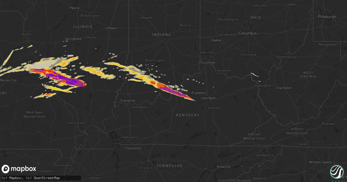
Hail Map on April 28, 2012
Get this storm
April 28 map
$229
one time, instant access
Download today. No call, no setup
Keep the $229
Bought the map and want the full workflow? Apply the entire $229 to a subscription within 7 days. None of it is wasted.
Every map, not just this one
This buys you this map. Subscription and you get every map we run, in the markets you choose from a few cities to whole states to nationwide. Plus real-time alerts the moment a storm fires.
Contact data
Name, contact info, occupancy, even credit band for addresses in the footprint. You go from where it hit to who to call.
Become the source they trust
Unlimited branding weather history reports on demand. You already have the documented answer ready for the property owner, and you are the one who showed up with it.
Property data and RoofTrace estimates
Pull up any address you have got, its value and the exact code rules for that jurisdiction, straight from One Click Code. Then RoofTrace estimates the squares, pitch, and roof value, priced the way you price.
States Impacted by Hail Map on April 28, 2012
Storm reports
Kentucky
| Date | Description |
|---|---|
| 04/28/20126:56 PM CDT | Slightly over 2 inch hail reported at churchill downs. |
| 04/28/20126:55 PM CDT | Possible window damage to cars. 50 mph winds as well. |
| 04/28/20126:53 PM CDT | Near crums lane. |
| 04/28/20126:52 PM CDT | In the portland area. |
| 04/27/20127:35 PM CDT | A local report indicates 1.75 inch wind near TAYLORSVILLE |
| 04/27/20127:30 PM CDT | Fell for 8 to 10 minutes. |
| 04/27/20127:21 PM CDT | A local report indicates 2.00 inch wind near 2 ESE FERN CREEK |
| 04/27/20127:20 PM CDT | Hail damage to vehicles and home siding. Hail at least quarter size... Quarter size hail remained in the yard nearly and hour after falling. In the billtown road area. |
| 04/27/20127:20 PM CDT | A local report indicates 1.75 inch wind near 2 ESE FERN CREEK |
| 04/27/20127:18 PM CDT | A local report indicates 1.75 inch wind near 4 NNE MOUNT WASHINGTON |
| 04/27/20127:14 PM CDT | A local report indicates 1.00 inch wind near FERN CREEK |
| 04/27/20127:13 PM CDT | A local report indicates 2.00 inch wind near HIGHVIEW |
| 04/27/20127:09 PM CDT | A local report indicates 1.00 inch wind near HIGHVIEW |
| 04/27/20127:07 PM CDT | In highlands |
| 04/27/20127:07 PM CDT | A local report indicates 1.25 inch wind near FERN CREEK |
| 04/27/20127:06 PM CDT | At louisville international airport. |
| 04/27/20127:05 PM CDT | A local report indicates 1.75 inch wind near HILLVIEW |
| 04/27/20127:02 PM CDT | At bowman field |
| 04/27/20127:02 PM CDT | At iroquois park |
| 04/27/20127:00 PM CDT | Near the v.a. Hospital. |
Illinois
| Date | Description |
|---|---|
| 04/28/20126:55 PM CDT | A local report indicates 1.00 inch wind near ST. PETER |
| 04/28/20126:50 PM CDT | Power lines and large limbs blown down. |
| 04/28/20126:07 PM CDT | A local report indicates 1.00 inch wind near OKAWVILLE |
| 04/28/20126:03 PM CDT | A local report indicates 1.75 inch wind near VENEDY |
| 04/28/20125:57 PM CDT | A local report indicates 2.75 inch wind near HOYLETON |
| 04/28/20125:55 PM CDT | A local report indicates 1.75 inch wind near 3 N VENEDY |
| 04/28/20125:50 PM CDT | A local report indicates 1.75 inch wind near ST. PAUL |
| 04/28/20125:38 PM CDT | A local report indicates 1.00 inch wind near NEW MINDEN |
| 04/28/20125:37 PM CDT | A local report indicates 1.00 inch wind near COVINGTON |
| 04/28/20125:20 PM CDT | Corrected for time |
| 04/28/20124:51 PM CDT | Started 15 minutes ago. Now ended. Car windshields broken. |
| 04/28/20124:50 PM CDT | A local report indicates 2.00 inch wind near GERMANTOWN |
| 04/28/20124:50 PM CDT | A local report indicates 1.50 inch wind near MASCOUTAH |
| 04/28/20124:50 PM CDT | A local report indicates 1.00 inch wind near NEW BADEN |
| 04/28/20124:46 PM CDT | A local report indicates 1.75 inch wind near MASCOUTAH |
| 04/28/20124:40 PM CDT | A local report indicates 1.75 inch wind near AVISTON |
| 04/28/20124:40 PM CDT | A local report indicates 1.75 inch wind near MASCOUTAH |
| 04/28/20124:33 PM CDT | On west side of town. |
| 04/28/20124:30 PM CDT | Just ended |
| 04/28/20124:30 PM CDT | Covering the ground |
| 04/28/20124:30 PM CDT | Damage to motor vehicles. |
| 04/28/20124:30 PM CDT | On i 64 near new baden road...three vehicles had back window shattered |
| 04/28/20124:30 PM CDT | Several large metal road signs blown down between ofallon and the county line along i 64...also a few large trees were snapped across the southeast portion of ofallon j |
| 04/28/20124:29 PM CDT | A local report indicates 1.00 inch wind near SWANSEA |
| 04/28/20124:28 PM CDT | East part of belleville |
| 04/28/20124:27 PM CDT | At scott afb |
| 04/28/20124:26 PM CDT | A local report indicates 1.75 inch wind near BELLEVILLE |
| 04/28/20124:25 PM CDT | Western part of belleville |
| 04/28/20124:22 PM CDT | Hail damaged numerous car windshields and home windows as well. |
| 04/28/20124:20 PM CDT | 8 to 10 inch limbs down |
| 04/28/20124:20 PM CDT | A local report indicates 2.50 inch wind near 2 S LEBANON |
| 04/28/20124:20 PM CDT | A local report indicates 4.50 inch wind near OKAWVILLE |
| 04/28/20124:19 PM CDT | A local report indicates 1.75 inch wind near SCOTT AFB |
| 04/28/20124:19 PM CDT | A local report indicates 2.50 inch wind near O'FALLON |
| 04/28/20124:17 PM CDT | A local report indicates 1.75 inch wind near CAHOKIA |
| 04/28/20124:15 PM CDT | Wind est 50 mph...small tree branches down |
| 04/28/20124:15 PM CDT | A local report indicates 1.50 inch wind near ROBINSON |
| 04/28/20124:15 PM CDT | Covering the ground 3 inches deep |
| 04/28/20124:14 PM CDT | A local report indicates 2.00 inch wind near FAIRVIEW HEIGHTS |
| 04/28/20124:12 PM CDT | A local report indicates 2.50 inch wind near O'FALLON |
| 04/28/20124:10 PM CDT | Est 60 to 70 mph winds...near green mount rd and i 64 |
| 04/28/20124:05 PM CDT | A local report indicates 2.20 inch wind near FAIRVIEW HEIGHTS |
| 04/28/20124:03 PM CDT | Leaves shredded from trees. Damaged roof shingles. Dents on cars. |
| 04/28/20124:00 PM CDT | A local report indicates 1.50 inch wind near OBLONG |
| 04/28/20123:59 PM CDT | A local report indicates 2.50 inch wind near COLLINSVILLE |
| 04/28/20123:59 PM CDT | At cahokia mounds |
| 04/28/20123:58 PM CDT | A local report indicates 1.00 inch wind near COLLINSVILLE |
| 04/28/20123:57 PM CDT | A local report indicates 1.00 inch wind near COLLINSVILLE |
| 04/28/20123:53 PM CDT | Ground is covered in hail |
| 04/28/20123:50 PM CDT | A local report indicates 2.50 inch wind near GRANITE CITY |
| 04/28/20123:48 PM CDT | A local report indicates 60 MPH wind near GRANITE CITY |
| 04/28/20123:43 PM CDT | A local report indicates 1.00 inch wind near GRANITE CITY |
| 04/28/20123:41 PM CDT | A local report indicates 1.50 inch wind near 4 S ROSE HILL |
| 04/28/20123:35 PM CDT | A local report indicates 1.00 inch wind near 4 S ROSE HILL |
| 04/27/201210:29 PM CDT | Hail covering ground. |
| 04/27/201210:00 PM CDT | 1 inch to 1.75 inch hail |
| 04/27/20129:39 PM CDT | Hail covering ground on south side of town. |
| 04/27/20129:35 PM CDT | A local report indicates 2.00 inch wind near 1 SSW MARISSA |
| 04/27/20129:01 PM CDT | At intersection of illinois route 3 and kaskaskia road. |
| 04/27/20129:00 PM CDT | Two small buildings had their roofs blown off. A couple trees blow over. |
| 04/27/20128:53 PM CDT | A local report indicates 1.25 inch wind near VALMEYER |
| 04/27/20127:56 PM CDT | A local report indicates 1.00 inch wind near CLAY CITY |
| 04/27/20127:20 PM CDT | A local report indicates 1.75 inch wind near 1 E LOUISVILLE |
| 04/27/20127:20 PM CDT | A local report indicates 1.75 inch wind near IOLA |
| 04/27/20127:18 PM CDT | A local report indicates 1.50 inch wind near IOLA |
| 04/27/20127:18 PM CDT | A local report indicates 1.50 inch wind near 1 E LOUISVILLE |
| 04/27/20127:07 PM CDT | At albers exit on i 64 |
| 04/27/20127:03 PM CDT | Enough hail that it looks like it snowed and very dense fog has now developed |
| 04/27/20127:03 PM CDT | Measured by a state trooper |
Indiana
| Date | Description |
|---|---|
| 04/28/20126:39 PM CDT | A local report indicates 1.75 inch wind near GEORGETOWN |
| 04/28/20126:33 PM CDT | Dime size hail covered the ground. |
| 04/28/20126:31 PM CDT | A local report indicates 1.50 inch wind near 1 SE CRANDALL |
| 04/28/20126:30 PM CDT | Power lines down |
| 04/28/20126:30 PM CDT | A local report indicates 1.00 inch wind near 4 W GEORGETOWN |
| 04/28/20126:25 PM CDT | A local report indicates 1.75 inch wind near NEW SALISBURY |
| 04/28/20126:25 PM CDT | Trees down. |
| 04/28/20126:22 PM CDT | A local report indicates 1.75 inch wind near PALMYRA |
| 04/28/20126:20 PM CDT | A local report indicates 1.75 inch wind near 2 N RAMSEY |
| 04/28/20126:18 PM CDT | A local report indicates 1.00 inch wind near FREDERICKSBURG |
| 04/28/20126:12 PM CDT | Report relayed by harrison co. Em. |
| 04/28/20126:10 PM CDT | A local report indicates 1.00 inch wind near MILLTOWN |
| 04/28/20126:05 PM CDT | Power lines down. Also hail large enough to damage cars. |
| 04/28/20126:02 PM CDT | A local report indicates 1.00 inch wind near ENGLISH |
| 04/28/20125:57 PM CDT | A local report indicates 1.50 inch wind near 5 S PAOLI |
| 04/28/20125:43 PM CDT | Near french lick municipal airport. |
| 04/28/20125:32 PM CDT | Power outages due to trees and powerlines down |
| 04/28/20125:22 PM CDT | A local report indicates 1.75 inch wind near 7 ESE WASHINGTON |
| 04/28/20125:06 PM CDT | A local report indicates 90 MPH wind near WASHINGTON |
| 04/28/20125:06 PM CDT | A local report indicates 1.50 inch wind near WASHINGTON |
| 04/28/20124:57 PM CDT | A local report indicates 1.75 inch wind near BICKNELL |
| 04/28/20124:53 PM CDT | A local report indicates 1.00 inch wind near BICKNELL |
| 04/28/20124:48 PM CDT | A local report indicates 60 MPH wind near VINCENNES |
| 04/28/20124:46 PM CDT | A local report indicates 1.00 inch wind near 3 E OAKTOWN |
| 04/28/20124:44 PM CDT | A local report indicates 60 MPH wind near BRUCEVILLE |
| 04/27/20129:27 PM CDT | One tree down blocking road |
Oklahoma
| Date | Description |
|---|---|
| 04/28/20124:20 AM CDT | Several large trees uprooted...5th wheel trailer rolled over...and damage to metal shed. |
| 04/28/20124:20 AM CDT | Several large trees uprooted...5th wheel trailer rolled over...and damage to metal shed. |
| 04/28/20122:15 AM CDT | Fell for 10 minutes and covered the ground. |
| 04/28/201212:58 AM CDT | A local report indicates 1.25 inch wind near TRYON |
| 04/28/201212:53 AM CDT | A local report indicates 65 MPH wind near TRYON |
| 04/28/201212:27 AM CDT | A local report indicates 1.00 inch wind near SAYRE |
| 04/28/201212:19 AM CDT | A local report indicates 1.00 inch wind near DOUGLAS |
| 04/28/201212:04 AM CDT | Reported at chandler lake |
| 04/28/201212:02 AM CDT | A local report indicates 1.00 inch wind near SAYRE |
| 04/27/201211:58 PM CDT | A local report indicates 1.00 inch wind near 3 ENE HILLSDALE |
| 04/27/201211:32 PM CDT | A local report indicates 1.00 inch wind near 4 ENE LAHOMA |
| 04/27/201211:26 PM CDT | A local report indicates 1.00 inch wind near 6 WSW EDMOND |
| 04/27/201211:21 PM CDT | A local report indicates 1.00 inch wind near 7 N BETHANY |
| 04/27/201211:20 PM CDT | A local report indicates 1.00 inch wind near 8 NE LOOKEBA |
| 04/27/201211:15 PM CDT | A local report indicates 1.25 inch wind near 5 N BETHANY |
| 04/27/201211:15 PM CDT | A local report indicates 1.00 inch wind near ERICK |
| 04/27/201211:00 PM CDT | A local report indicates 1.75 inch wind near 4 SSW DRUMMOND |
| 04/27/201211:00 PM CDT | A local report indicates 1.00 inch wind near 1 N LOOKEBA |
| 04/27/201210:30 PM CDT | A local report indicates 1.75 inch wind near 2 SE EL RENO |
| 04/27/20129:48 PM CDT | A local report indicates 1.75 inch wind near 1 NE HINTON |
| 04/27/20129:46 PM CDT | A local report indicates 1.25 inch wind near HINTON |
Texas
| Date | Description |
|---|---|
| 04/28/20124:00 AM CDT | A local report indicates 1.00 inch wind near 1 NE MCLEAN |
| 04/28/20123:55 AM CDT | Quarter to golfball size hail northeast of bishop hills. |
| 04/28/20123:40 AM CDT | Mostly nickel size hail with some larger up to quarters in valley de oro. |
| 04/28/20123:33 AM CDT | Quarter size hail reported north of wildorado |
| 04/28/20123:18 AM CDT | Penny to quarter size hail with wind gusts around 60 mph near groom. |
| 04/28/20123:18 AM CDT | Penny to quarter size hail with wind gusts around 60 mph near groom. |
| 04/28/20123:15 AM CDT | A local report indicates 1.50 inch wind near ALLISON |
| 04/28/20123:15 AM CDT | Golf ball size hail reported near vega |
| 04/28/20123:05 AM CDT | Quarter size hail reported on southwest side of amarillo |
| 04/28/20123:00 AM CDT | A local report indicates 1.00 inch wind near 4 WNW AMARILLO |
| 04/28/20122:55 AM CDT | Golf ball size hail reported on southwest side of amarillo |
| 04/28/20122:50 AM CDT | Three 18 wheelers were either rolled over or blown into a ditch while on interstate 40 between amarillo and groom. No injuries have been reported at this time. |
| 04/28/20122:46 AM CDT | Hail reported north of mobeetie |
| 04/28/20122:45 AM CDT | Pea to quarter size hail reported in sleepy hollow subdivision off of coulter street in amarillo. |
| 04/28/20122:42 AM CDT | Quarter to golfball size hail reported in skellytown. |
| 04/28/20122:10 AM CDT | Quarter size hail near palo duro high school in amarillo. |
| 04/28/20122:07 AM CDT | Golf ball size hail reported in pampa |
| 04/28/20122:02 AM CDT | Quarter size hail reported on polk street in downtown amarillo. |
| 04/28/20122:00 AM CDT | River road area |
| 04/28/20122:00 AM CDT | Sheriff deputy reported ping pong size hail. |
| 04/28/201212:10 AM CDT | A local report indicates 2.00 inch wind near SHAMROCK |
| 04/28/201212:06 AM CDT | A local report indicates 2.50 inch wind near SHAMROCK |
| 04/27/201211:58 PM CDT | A local report indicates 1.75 inch wind near 1 SW SHAMROCK |
| 04/27/201211:05 PM CDT | A local report indicates 1.50 inch wind near 2 W MEMPHIS |
| 04/27/201210:37 PM CDT | A local report indicates 1.50 inch wind near WELLINGTON |
| 04/27/201210:37 PM CDT | A local report indicates 1.25 inch wind near GIRARD |
| 04/27/201210:20 PM CDT | A local report indicates 1.75 inch wind near GIRARD |
| 04/27/20129:51 PM CDT | A local report indicates 1.75 inch wind near ESTELLINE |
| 04/27/20129:43 PM CDT | Time estimated |
| 04/27/20129:24 PM CDT | A local report indicates 1.75 inch wind near SWENSON |
| 04/27/20128:56 PM CDT | A local report indicates 73 MPH wind near 6 S PEACOCK |
| 04/27/20128:56 PM CDT | A local report indicates 3.00 inch wind near 6 S PEACOCK |
| 04/27/20128:45 PM CDT | A local report indicates 1.00 inch wind near 2 S PEACOCK |
| 04/27/20128:33 PM CDT | A local report indicates 1.00 inch wind near 3 SW JAYTON |
| 04/27/20128:33 PM CDT | A local report indicates 1.25 inch wind near 4 W JAYTON |
| 04/27/20128:28 PM CDT | A local report indicates 1.00 inch wind near 6 SW JAYTON |
| 04/27/20127:25 PM CDT | A local report indicates 1.00 inch wind near LAKE ALAN HENRY |
Missouri
| Date | Description |
|---|---|
| 04/28/20126:33 PM CDT | From the kmov weather camera. |
| 04/28/20126:30 PM CDT | A local report indicates 1.75 inch wind near ST. LOUIS |
| 04/28/20126:29 PM CDT | On north side of town. |
| 04/28/20126:29 PM CDT | Golfball sized hail at tucker and market. |
| 04/28/20126:26 PM CDT | A local report indicates 1.50 inch wind near 3 SE HEMATITE |
| 04/28/20126:24 PM CDT | Large tree was uprooted onto a house causing minor roof damage on potomac avenue. |
| 04/28/20126:24 PM CDT | North city. |
| 04/28/20126:24 PM CDT | Large tree was blown over onto an unoccupied car on marquette avenue. |
| 04/28/20126:24 PM CDT | A large tree was blown over onto a house on pernod avenue...causing moderate damage. |
| 04/28/20126:21 PM CDT | A local report indicates 1.25 inch wind near ST. LOUIS |
| 04/28/20126:20 PM CDT | Near edwards jones dome |
| 04/28/20126:20 PM CDT | A local report indicates 2.50 inch wind near OVERLAND |
| 04/28/20126:20 PM CDT | A local report indicates 1.00 inch wind near RICHMOND HEIGHTS |
| 04/28/20126:20 PM CDT | Retired |
| 04/28/20126:20 PM CDT | 15 inch tree snapped near intersection of mackland and southwest avenue. Time approximate from radar. |
| 04/28/20126:19 PM CDT | A local report indicates 1.75 inch wind near OVERLAND |
| 04/28/20126:19 PM CDT | Washington university |
| 04/28/20126:15 PM CDT | 1 mile south of i 70 on st. Charles rock road...golfball size hail lasted for 15 minutes |
| 04/28/20126:15 PM CDT | Relayed from public |
| 04/28/20126:15 PM CDT | 2.5 ft diamter tree uprooted |
| 04/28/20126:13 PM CDT | A local report indicates 1.50 inch wind near ST. JOHN |
| 04/28/20126:11 PM CDT | Two and a half foot diamter tree truck snapped. Time estimated from radar. |
| 04/28/20126:11 PM CDT | Hail covering ground. 55mph wind gusts measured as well. |
| 04/28/20126:10 PM CDT | A local report indicates 1.75 inch wind near ST. ANN |
| 04/28/20126:10 PM CDT | A local report indicates 1.75 inch wind near OVERLAND |
| 04/28/20126:10 PM CDT | A local report indicates 1.50 inch wind near OLIVETTE |
| 04/28/20126:09 PM CDT | A local report indicates 2.00 inch wind near MARYLAND HEIGHTS |
| 04/28/20126:08 PM CDT | A local report indicates 1.75 inch wind near ST. ANN |
| 04/28/20126:07 PM CDT | A local report indicates 1.50 inch wind near MARYLAND HEIGHTS |
| 04/28/20126:07 PM CDT | Severall vehicles in the area with broken windows. |
| 04/28/20126:06 PM CDT | A local report indicates 1.25 inch wind near 2 SSE BRIDGETON |
| 04/28/20126:05 PM CDT | A local report indicates 1.75 inch wind near DE SOTO |
| 04/28/20126:05 PM CDT | A local report indicates 1.50 inch wind near 1 NW CREVE COEUR |
| 04/28/20126:05 PM CDT | A local report indicates 1.75 inch wind near OVERLAND |
| 04/28/20126:03 PM CDT | A local report indicates 1.75 inch wind near CREVE COEUR |
| 04/28/20126:02 PM CDT | A local report indicates 1.00 inch wind near BRIDGETON |
| 04/28/20126:01 PM CDT | West side of town. |
| 04/28/20126:00 PM CDT | A local report indicates 2.00 inch wind near CREVE COEUR |
| 04/28/20125:59 PM CDT | Near 364 and upper bottom rd |
| 04/28/20125:57 PM CDT | Near i 70 and 5th street |
| 04/28/20125:50 PM CDT | A local report indicates 1.75 inch wind near ST. PAUL |
| 04/28/20125:50 PM CDT | At intersection of kimberly and st. Peters howell. |
| 04/28/20125:48 PM CDT | Relayed from the public |
| 04/28/20125:45 PM CDT | A local report indicates 2.00 inch wind near 2 NW O'FALLON |
| 04/28/20125:42 PM CDT | A local report indicates 1.75 inch wind near ST. PAUL |
| 04/28/20125:41 PM CDT | A local report indicates 3.00 inch wind near WENTZVILLE |
| 04/28/20125:39 PM CDT | South side of town. |
| 04/28/20125:35 PM CDT | A local report indicates 2.75 inch wind near FLINT HILL |
| 04/28/20125:34 PM CDT | A local report indicates 1.75 inch wind near WENTZVILLE |
| 04/28/20125:33 PM CDT | Plywood and other small pieces of debris on westbound lanes of interstate 70 between mile markers 212 and 213. |
| 04/28/20125:30 PM CDT | A local report indicates 1.75 inch wind near 2 W WENTZVILLE |
| 04/28/20125:28 PM CDT | A local report indicates 2.75 inch wind near WENTZVILLE |
| 04/28/20125:20 PM CDT | A local report indicates 1.75 inch wind near 2 N WRIGHT CITY |
| 04/28/20125:17 PM CDT | Hail covering ground. |
| 04/28/20125:08 PM CDT | A local report indicates 1.25 inch wind near 2 N WARRENTON |
| 04/28/20124:30 PM CDT | Just north of intersection of hwy j and ww |
| 04/28/20123:44 PM CDT | Has lasted over 5 minutes |
| 04/28/20123:42 PM CDT | A local report indicates 1.25 inch wind near FERGUSON |
| 04/28/20123:35 PM CDT | A local report indicates 1.75 inch wind near FLORISSANT |
| 04/28/20123:28 PM CDT | Near intersection of charbonier and shackelford |
| 04/28/20123:28 PM CDT | A local report indicates 1.75 inch wind near HAZELWOOD |
| 04/28/20123:27 PM CDT | Reported at lambert airport |
| 04/28/20123:26 PM CDT | A local report indicates 2.00 inch wind near 1 N HAZELWOOD |
| 04/28/20123:25 PM CDT | Several reports of golfball size hail in hazelwood |
| 04/28/20123:25 PM CDT | 3 miles west of lambert |
| 04/28/20123:25 PM CDT | A local report indicates 1.25 inch wind near FLORISSANT |
| 04/28/20123:25 PM CDT | Two trees snapped at the base with 1 ft trunk diameter |
| 04/28/20123:24 PM CDT | A local report indicates 1.00 inch wind near 1 N HAZELWOOD |
| 04/28/20123:23 PM CDT | A local report indicates 1.75 inch wind near 2 NW FLORISSANT |
| 04/28/20123:15 PM CDT | A local report indicates 1.50 inch wind near 2 N ST. CHARLES |
| 04/28/20123:14 PM CDT | Near intersection of elm and hunters ridge |
| 04/28/20122:40 PM CDT | 2 miles north of interstate 70 on us hwy 61 |
| 04/28/20122:39 PM CDT | A local report indicates 1.00 inch wind near 3 NW WENTZVILLE |
| 04/28/20122:30 PM CDT | A local report indicates 1.00 inch wind near 4 N WRIGHT CITY |
| 04/28/20121:18 PM CDT | A local report indicates 1.00 inch wind near 3 E FULTON |
| 04/28/20122:45 AM CDT | A local report indicates 1.00 inch wind near CENTRALIA |
| 04/28/20122:25 AM CDT | A local report indicates 1.00 inch wind near 3 NE HALLSVILLE |
| 04/27/20128:53 PM CDT | A local report indicates 1.25 inch wind near VALLES MILL |
| 04/27/20128:36 PM CDT | A local report indicates 1.50 inch wind near BARNHART |
| 04/27/20128:25 PM CDT | A local report indicates 1.00 inch wind near OTTO |
Kansas
| Date | Description |
|---|---|
| 04/28/20125:04 AM CDT | Spotter reported winds at 45 gusting to 60. |
| 04/28/20125:04 AM CDT | A local report indicates 1.00 inch wind near CHEROKEE |
| 04/28/20124:24 AM CDT | A local report indicates 1.00 inch wind near 2 ESE CHEROKEE |
Cities Impacted by Hail Map on April 28, 2012
- French Lick, IN
- Paoli, IN
- Aspermont, TX
- Old Glory, TX
- Medford, OK
- Milltown, IN
- Lawrenceville, IL
- Washington, IN
- Montgomery, IN
- Lanesville, IN
- Floyds Knobs, IN
- Fredericksburg, IN
- Oaktown, IN
- Wheeler, IL
- New Albany, IN
- New Salisbury, IN
- Marengo, IN
- Oblong, IL
- Cannelburg, IN
- Willow Hill, IL
- Flat Rock, IL
- Newton, IL
- Palestine, IL
- Hidalgo, IL
- English, IN
- Stoy, IL
- West Baden Springs, IN
- Ramsey, IN
- Hardinsburg, IN
- Carlisle, IN
- Shoals, IN
- Depauw, IN
- Taswell, IN
- Loogootee, IN
- Robinson, IL
- Louisville, KY
- Georgetown, IN
- Edwardsport, IN
- Shelbyville, KY
- Fisherville, KY
- Bicknell, IN
- Yale, IL
- Plainville, IN
- Dieterich, IL
- Corydon, IN
- Dubois, IN
- Palmyra, IN
- Mount Eden, KY
- Finchville, KY
- Waddy, KY
- Elizabeth, IN
- Bruceville, IN
- Taylorsville, KY
- Greenville, IN
- Crandall, IN
- Wellington, TX
- Shamrock, TX
- Wentzville, MO
- Hazelwood, MO
- Defiance, MO
- Wright City, MO
- Lake Saint Louis, MO
- Moscow Mills, MO
- Brussels, IL
- Warrenton, MO
- Troy, MO
- Old Monroe, MO
- Golden Eagle, IL
- Saint Charles, MO
- O'Fallon, MO
- Saint Peters, MO
- Florissant, MO
- Saint Louis, MO
- Foristell, MO
- Yukon, OK
- Hinton, OK
- Lookeba, OK
- Binger, OK
- Union City, OK
- El Reno, OK
- Minco, OK
- Oklahoma City, OK
- Calumet, OK
- Cleveland, OK
- Adrian, TX
- Vega, TX
- Silex, MO
- Galena, KS
- Amarillo, TX
- Bolivar, MO
- Polk, MO
- Flemington, MO
- Wellsville, MO
- Middletown, MO
- Montgomery City, MO
- Belleville, IL
- Hydro, OK
- Braman, OK
- De Soto, MO
- Festus, MO
- Fletcher, MO
- East Carondelet, IL
- Foley, MO
- Elsberry, MO
- Childress, TX
- Tell, TX
- Quanah, TX
- Memphis, TX
- Mannford, OK
- Jennings, OK
- Prue, OK
- Terlton, OK
- Osage, OK
- Taloga, OK
- Alton, IL
- Litchfield, IL
- Dow, IL
- Mount Olive, IL
- Gillespie, IL
- Godfrey, IL
- Butler, IL
- Hillsboro, IL
- Irving, IL
- Brighton, IL
- Bunker Hill, IL
- Carlinville, IL
- Shipman, IL
- Jerseyville, IL
- Dorsey, IL
- Trenton, IL
- Earth City, MO
- East Saint Louis, IL
- Scott Air Force Base, IL
- Bartelso, IL
- Lovejoy, IL
- New Baden, IL
- Dupo, IL
- Caseyville, IL
- Lebanon, IL
- Albers, IL
- Granite City, IL
- Maryland Heights, MO
- Nashville, IL
- O'Fallon, IL
- Madison, IL
- Aviston, IL
- Troy, IL
- Germantown, IL
- Fairview Heights, IL
- Bridgeton, MO
- Summerfield, IL
- Mascoutah, IL
- Addieville, IL
- Millstadt, IL
- Venice, IL
- Chesterfield, MO
- Collinsville, IL
- Saint Ann, MO
- Okawville, IL
- Liberal, MO
- Mindenmines, MO
- Okarche, OK
- Piedmont, OK
- Tonkawa, OK
- Nardin, OK
- Lamont, OK
- Hunter, OK
- Wellston, OK
- Luther, OK
- Jones, OK
- Blackwell, MO
- Pampa, TX
- Williamsburg, MO
- Centralia, IL
- Hoyleton, IL
- Sentinel, OK
- Carter, OK
- Dill City, OK
- Matador, TX
- Turkey, TX
- Lakeview, TX
- Augusta, MO
- Marthasville, MO
- Briscoe, TX
- Parkersburg, IL
- Girard, TX
- Mobeetie, TX
- Fenton, MO
- Skellytown, TX
- Udall, KS
- Tryon, OK
- Agra, OK
- Meridian, OK
- Carney, OK
- Butler, OK
- Willow, OK
- Elk City, OK
- Granite, OK
- Canute, OK
- Santa Fe, MO
- Stoutsville, MO
- Center, MO
- Perry, MO
- Wheeler, TX
- Panhandle, TX
- Groom, TX
- White Deer, TX
- Mclean, TX
- Borden, IN
- Sellersburg, IN
- Jayton, TX
- Pekin, IN
- Manchester, OK
- Conway Springs, KS
- Bluff City, KS
- Freeport, KS
- Caldwell, KS
- Wakita, OK
- Argonia, KS
- Pond Creek, OK
- Nash, OK
- Milan, KS
- Hollis, OK
- Stillwater, OK
- Corn, OK
- Cushing, OK
- Pittsburg, KS
- Cherokee, KS
- Weir, KS
- Edwardsville, IL
- Raymond, IL
- Staunton, IL
- Worden, IL
- Moro, IL
- Benld, IL
- Cottage Hills, IL
- Bethalto, IL
- Wilsonville, IL
- Medora, IL
- Nokomis, IL
- Witt, IL
- Sawyerville, IL
- East Alton, IL
- Piasa, IL
- Monroe City, IN
- Vincennes, IN
- Wheatland, IN
- Clinton, OK
- Hammon, OK
- Frankford, MO
- New London, MO
- Custer City, OK
- Thomas, OK
- Putnam, OK
- Canadian, TX
- Columbia, MO
- Sayre, OK
- Erick, OK
- Perry, OK
- Waukomis, OK
- Enid, OK
- Nilwood, IL
- Leedey, OK
- Hedley, TX
- Quail, TX
- Marissa, IL
- Lenzburg, IL
- New Athens, IL
- Snyder, TX
- Asbury, MO
- Red Bud, IL
- Baldwin, IL
- Imperial, MO
- Barnhart, MO
- House Springs, MO
- Waterloo, IL
- Valmeyer, IL
- Hillsboro, MO
- Pevely, MO
- Seiling, OK
- Oakwood, OK
- Sulphur, IN
- Winfield, KS
- Oxford, KS
- Geuda Springs, KS
- South Haven, KS
- Douglass, KS
- Rock, KS
- Carlyle, IL
- Breese, IL
- Ramona, OK
- Bartlesville, OK
- Saint Peter, IL
- Farina, IL
- Kinmundy, IL
- Baxter Springs, KS
- Edmond, OK
- Perkins, OK
- Guthrie, OK
- Coyle, OK
- Ripley, OK
- New Florence, MO
- Saint Jacob, IL
- Portage Des Sioux, MO
- Irvington, IL
- Glen Carbon, IL
- Jonesburg, MO
- Maryville, IL
- High Hill, MO
- Truesdale, MO
- Richview, IL
- Freeburg, IL
- Columbia, IL
- Hoffman, IL
- Simpsonville, KY
- Weatherford, OK
- Arapaho, OK
- Owensburg, IN
- Bloomfield, IN
- Pawnee, OK
- Canton, OK
- Watonga, OK
- Fay, OK
- Miami, TX
- Fulton, MO
- Sullivan, MO
- Skiatook, OK
- Belle Plaine, KS
- Blackwell, OK
- Meno, OK
- Drummond, OK
- Lahoma, OK
- Ames, OK
- Xenia, IL
- Hermitage, MO
- Tunas, MO
- Louisburg, MO
- Half Way, MO
- Urbana, MO
- Paducah, TX
- Oswego, KS
- Delaware, OK
- Isabella, OK
- Wildorado, TX
- Sheldon, MO
- Lamar, MO
- Kingdom City, MO
- Lockwood, MO
- Jerico Springs, MO
- Dadeville, MO
- Arcola, MO
- El Dorado Springs, MO
- Stockton, MO
- Geary, OK
- Smithboro, IL
- Mulberry Grove, IL
- Greenville, IL
- Marshall, OK
- Crescent, OK
- New Bloomfield, MO
- Auxvasse, MO
- Ashland, MO
- Kremlin, OK
- Lenapah, OK
- Arkansas City, KS
- Owenton, KY
- Okeene, OK
- Kingfisher, OK
- Hennessey, OK
- Fairview, OK
- Chester, OK
- Spur, TX
- Dickens, TX
- Leon, KS
- Lindsborg, KS
- Assaria, KS
- O'Brien, TX
- Rochester, TX
- Hominy, OK
- Justiceburg, TX
- Pittsburg, MO
- Preston, MO
- Fair Play, MO
- Macks Creek, MO
- Dunnegan, MO
- Centralia, MO
- Bronaugh, MO
- Mangum, OK
- Linton, IN
- Carrollton, MO
- Vandalia, IL
- Shobonier, IL
- Campbellsburg, IN
- Richwoods, MO
- New Douglas, IL
- Sorento, IL
- Orleans, IN
- Rothville, MO
- Milo, MO
- McCune, KS
- Girard, KS
- Frontenac, KS
- Columbus, KS
- Scammon, KS
- Fairfax, OK
- Hartsburg, MO
- California, MO
- Centertown, MO
- Jamestown, MO
- Omega, OK
- Bellflower, MO
- Independence, KS
- Liberty, KS
- Colony, OK
- Cordell, OK
- Arnett, OK
- Loyal, OK
- Lucien, OK
- Cheyenne, OK
- Fairmont, OK
- Durham, OK
- Crawford, OK
- Reydon, OK
- Sweetwater, OK
- Claude, TX
- Covington, OK
- Hitchcock, OK
- Foss, OK
- Bison, OK
- Douglas, OK
- Greenfield, OK
- Gould, OK
- Barnsdall, OK
- Wynona, OK
- Rockbridge, IL
- Hartford, IL
- Highland, IL
- Carrier, OK
- Chandler, OK
- Billings, OK
- Garber, OK
- Inman, KS
- Moundridge, KS
- Galva, KS
- Mcpherson, KS
- Dodson, TX
- Ringwood, OK
- Goltry, OK
- West Alton, MO
- Decker, IN
- Waggoner, IL
- Miami, OK
- Welch, OK
- Bedford, IN
- Tonganoxie, KS
- Bonner Springs, KS
- Kansas City, KS
- Basehor, KS
- Linwood, KS
- Pocahontas, IL
- Vinson, OK
- Drumright, OK
- Arcadia, OK
- Yale, OK
- Spencer, OK
- Maramec, OK
- Louisville, IL
- Flora, IL
- S Coffeyville, OK
- Coffeyville, KS
- High Ridge, MO
- Valley Park, MO
- Eureka, MO
- Abilene, KS
- Golden City, MO
- Greenup, IL
- Casey, IL
- Truxton, MO
- Alba, MO
- Jasper, MO
- Webb City, MO
- Oronogo, MO
- Potosi, MO
- Effingham, IL
- Teutopolis, IL
- Batchtown, IL
- Fieldon, IL
- Hardin, IL
- Odon, IN
- Morrison, OK
- Caney, KS
- Bartlett, KS
- Edna, KS
- Coffeen, IL
- Orlando, OK
- Hallsville, MO
- La Grange, KY
- Crestwood, KY
- Goshen, KY
- Fults, IL
- Edgewood, IL
- Toledo, IL
- Dittmer, MO
- Waverly, IL
- Ramsey, IL
- Ralston, OK
- Paris, MO
- Hawk Point, MO
- Winfield, MO
- Grafton, IL
- Freelandville, IN
- Sandborn, IN
- Sullivan, IN
- Jeffersonville, IN
- Jasper, IN
- Bloomfield, KY
- Elnora, IN
- Salem, IN
- Mount Washington, KY
- Sumner, IL
- Merom, IN
- Petersburg, IN
- Westphalia, IN
- Crane, IN
- Clarksville, IN
- Mitchell, IN
- Lawrenceburg, KY
- Thompson, MO
- Olney, IL
- Noble, IL
- Clay City, IL
- Brownstown, IL
- Alma, IL
- Mason, IL
- Sparta, IL
- Tilden, IL
- Coulterville, IL
- Cedar Hill, MO
- Saint Libory, IL
- Vernon, IL
- Saint Elmo, IL
- Glenview, KY
- Prospect, KY
- Kane, IL
- Vici, OK
- Hereford, TX
- Red Rock, OK
- Dover, OK
- Cee Vee, TX
- Bethany, OK
- Camargo, OK
- Purcell, MO
- Carthage, MO
- Carl Junction, MO
- Joplin, MO
- Pawhuska, OK
- Calhoun, IL
- Ingraham, IL
- Vernon, TX
- Cadet, MO
- Bourbon, MO
- Lyons, IN
- Switz City, IN
- Eldred, IL
- Carrollton, IL
- Louisiana, MO
- Bloomington, IN
- Springville, IN
- Clarksville, MO
- Leasburg, MO
- Crowell, TX
- Shidler, OK
- Cynthiana, KY
- Palmyra, IL
- Modesto, IL
- Mulberry, KS
- Newton, KS
- Sedgwick, KS
- Valley Center, KS
- Chetopa, KS
- Fidelity, IL
- Catawissa, MO
- Elsah, IL
- Smithton, IL
- Portland, MO
- Steedman, MO
- Pacific, MO
- Hamburg, IL
- Ballwin, MO
- Chesterfield, IL
- Charlestown, IN
- Peru, KS
- Portsmouth, OH
- Pedro, OH
- Wheelersburg, OH
- Bedford, KY
- Wooldridge, MO
- Marceline, MO
- Pewee Valley, KY
- Heltonville, IN
- Campbellsburg, KY
- Saint Francisville, IL
- Sedan, KS
- Turners Station, KY
- Worthville, KY
- Sanders, KY
- Hale, MO
- San Jon, NM
- Bard, NM
- Ironton, OH
- Kitts Hill, OH
- Williams, IN
- Fluvanna, TX
- Mendon, MO
- Aldrich, MO
- Roach, MO
- Franklin, KS
- Greenfield, MO
- West Mineral, KS
- Canyon, TX
- Saint Paul, KS
- Lerna, IL
- New Berlin, IL
- Villa Ridge, MO
- Robertsville, MO
- Gypsum, KS
- Vallonia, IN
- Glencoe, OK
- Montrose, IL
- Jewett, IL
- Wakefield, KS
- Alhambra, IL
- Altamont, KS
- Parsons, KS
- Havana, KS
- Hobart, OK
- Nowata, OK