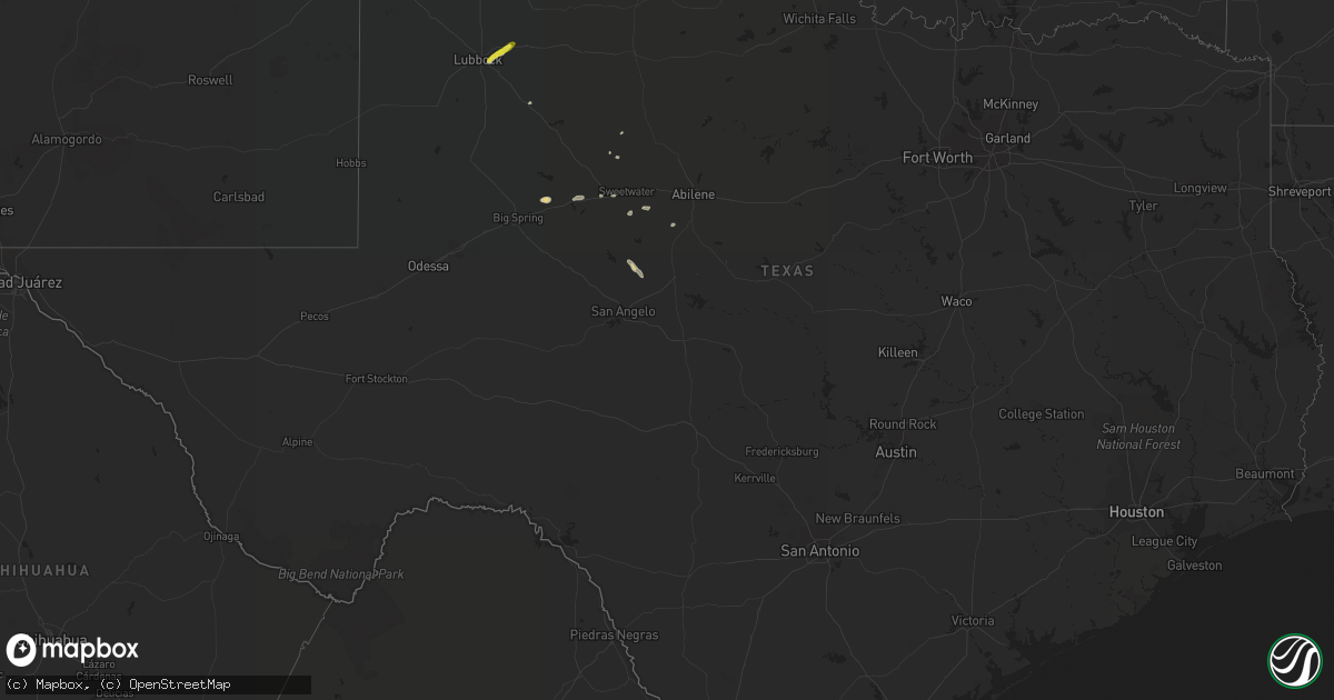
Hail Map in Texas on April 24, 2018
Get this storm
April 24 map
$229
one time, instant access
Download today. No call, no setup
Keep the $229
Bought the map and want the full workflow? Apply the entire $229 to a subscription within 7 days. None of it is wasted.
Every map, not just this one
This buys you this map. Subscription and you get every map we run, in the markets you choose from a few cities to whole states to nationwide. Plus real-time alerts the moment a storm fires.
Contact data
Name, contact info, occupancy, even credit band for addresses in the footprint. You go from where it hit to who to call.
Become the source they trust
Unlimited branding weather history reports on demand. You already have the documented answer ready for the property owner, and you are the one who showed up with it.
Property data and RoofTrace estimates
Pull up any address you have got, its value and the exact code rules for that jurisdiction, straight from One Click Code. Then RoofTrace estimates the squares, pitch, and roof value, priced the way you price.
Storm reports in Texas
Texas
| Date | Description |
|---|---|
| 04/24/20183:18 AM CDT | At 817 PM CDT, a severe thunderstorm was located near Tennyson, or 16 miles west of Ballinger, moving southeast at 25 mph. HAZARD...60 mph wind gusts and penny size hail. SOURCE...Radar indicated. IMPACT...Expect damage to roofs, siding, and trees. This severe thunderstorm will be near, Miles and Rowena around 845 PM CDT. |
| 04/24/20182:50 AM CDT | At 750 PM CDT, a severe thunderstorm was located near Hamby, or 12 miles northeast of Abilene, moving east at 45 mph. HAZARD...60 mph wind gusts. SOURCE...Radar indicated. IMPACT...Expect damage to roofs, siding, and trees. This severe thunderstorm will be near, Moran around 830 PM CDT. Other locations impacted by this severe thunderstorm include LakeFort Phantom Hill, Mccarty Lake, Us-283 Near The Callahan-Shackelford County Line and Us-180 Near The Shackelford-Stephens County Line.This includes Interstate 20 between Mile Markers 286 and 287. |
| 04/24/20182:45 AM CDT | At 745 PM CDT, a severe thunderstorm was located near Bronte, or 8 miles east of Robert Lee, moving southeast at 15 mph. HAZARD...60 mph wind gusts and quarter size hail. SOURCE...Radar indicated. IMPACT...Hail damage to vehicles is expected. Expect wind damage to roofs, siding, and trees. This severe thunderstorm will be near, Bronte around 750 PM CDT. Maverick and Tennyson around 815 PM CDT. |
| 04/24/20182:09 AM CDT | At 708 PM CDT, a severe thunderstorm was located near Neinda, or 10 miles west of Anson, moving east at 20 mph. HAZARD...60 mph wind gusts and quarter size hail. SOURCE...Radar indicated. IMPACT...Hail damage to vehicles is expected. Expect wind damage to roofs, siding, and trees. This severe thunderstorm will be near, Anson around 735 PM CDT. Hawley around 745 PM CDT. Other locations impacted by this severe thunderstorm include Funston,Hodges, The Intersection Of Us-180 And Ranch Road 126 and Truby. |
| 04/24/20181:46 AM CDT | At 646 PM CDT, a severe thunderstorm was located near Ransom Canyon, or 8 miles east of Lubbock, moving northeast at 10 mph. HAZARD...60 mph wind gusts and quarter size hail. SOURCE...Radar indicated. IMPACT...Hail damage to vehicles is expected. Expect wind damage to roofs, siding, and trees. Locations impacted include... Lubbock, Slaton, Idalou, Lorenzo and Ransom Canyon. |
| 04/23/20188:17 PM CDT | 2 downed power lines in clyde and baird. Mesonet station in clyde measured peak gust of 44 mph. |
| 04/23/20188:00 PM CDT | Stripes convenience store sign was damaged. |
| 04/23/20187:10 PM CDT | Along highway 62. |
All States Impacted by Hail Map on April 24, 2018
Cities Impacted by Hail Map on April 24, 2018
- Hobe Sound, FL
- Jupiter, FL
- Westbrook, TX
- Coahoma, TX
- Bronte, TX
- Palm Beach Gardens, FL
- Idalou, TX
- Lubbock, TX
- Miles, TX
- Roscoe, TX
- Mount Pleasant, NC
- Albemarle, NC
- Port Saint Lucie, FL
- Okeechobee, FL
- Ovalo, TX
- Stuart, FL
- Indiantown, FL
- Slaton, TX
- Lorenzo, TX
- Loxahatchee, FL
- West Palm Beach, FL
- Post, TX
- Palm Beach, FL
- Lake Worth, FL
- Colorado City, TX
- Coleman, TX
- Talpa, TX
- Nolan, TX
- Loraine, TX
- Gold Hill, NC
- Roby, TX
- Rotan, TX
- Maxton, NC
- Red Springs, NC
- Shannon, NC
- Richfield, NC


