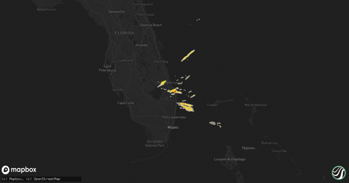
Hail Map on April 24, 2018
Get this storm
April 24 map
$229
one time, instant access
Download today. No call, no setup
Keep the $229
Bought the map and want the full workflow? Apply the entire $229 to a subscription within 7 days. None of it is wasted.
Every map, not just this one
This buys you this map. Subscription and you get every map we run, in the markets you choose from a few cities to whole states to nationwide. Plus real-time alerts the moment a storm fires.
Contact data
Name, contact info, occupancy, even credit band for addresses in the footprint. You go from where it hit to who to call.
Become the source they trust
Unlimited branding weather history reports on demand. You already have the documented answer ready for the property owner, and you are the one who showed up with it.
Property data and RoofTrace estimates
Pull up any address you have got, its value and the exact code rules for that jurisdiction, straight from One Click Code. Then RoofTrace estimates the squares, pitch, and roof value, priced the way you price.
States Impacted by Hail Map on April 24, 2018
Storm reports
North Carolina
| Date | Description |
|---|---|
| 04/24/20186:00 PM CDT | Emergency manager reports several trees down. |
| 04/24/20184:38 PM CDT | 2 trees downed and powerlines down by storm wind on hudspeth road which is just out from charlotte motor speedway. At least one of the trees described as 3 feet in diam |
| 04/24/20184:38 PM CDT | A bradford pear tree split not far from charlotte motor speedway. |
| 04/24/20182:59 PM CDT | Quarter-sized hail reported on hall road. |
| 04/24/20182:50 PM CDT | Tree down mcqueen st near s. Duffy road. |
| 04/24/20181:37 AM CDT | At 635 PM EDT, a severe thunderstorm was located over Mt Pleasant, or 9 miles east of Downtown Concord, moving east at 25 mph. HAZARD...60 mph wind gusts and quarter size hail. SOURCE...Trained weather spotters. IMPACT...Hail damage to vehicles is expected. Expect wind damage to roofs, siding, and trees. Locations impacted include... Albemarle, Badin Lake, Plyler, Badin, Richfield, New London, Morrow Mountain State Park, Finger and Lake Tillery. |
| 04/23/201811:26 PM CDT | At 426 PM EDT, a severe thunderstorm was located near Raeford, moving northeast at 20 mph. HAZARD...60 mph wind gusts and quarter size hail. SOURCE...Radar indicated. IMPACT...Hail damage to vehicles is possible. Expect wind damage to roofs, siding, and trees. Locations impacted include... Fayetteville, Raeford, Fort Bragg, Antioch, Pope AFB, Silver City, Rockfish and Bowmore. |
| 04/23/201810:25 PM CDT | At 324 PM EDT, a severe thunderstorm was located over Wakulla, or near Red Springs, moving northeast at 15 mph. HAZARD...60 mph wind gusts and quarter size hail. SOURCE...Radar indicated. IMPACT...Hail damage to vehicles is possible. Expect wind damage to roofs, siding, and trees. Locations impacted include... Raeford, Antioch, Hope Mills, Silver City, Rockfish and Bowmore. |
Texas
| Date | Description |
|---|---|
| 04/24/20183:18 AM CDT | At 817 PM CDT, a severe thunderstorm was located near Tennyson, or 16 miles west of Ballinger, moving southeast at 25 mph. HAZARD...60 mph wind gusts and penny size hail. SOURCE...Radar indicated. IMPACT...Expect damage to roofs, siding, and trees. This severe thunderstorm will be near, Miles and Rowena around 845 PM CDT. |
| 04/24/20182:50 AM CDT | At 750 PM CDT, a severe thunderstorm was located near Hamby, or 12 miles northeast of Abilene, moving east at 45 mph. HAZARD...60 mph wind gusts. SOURCE...Radar indicated. IMPACT...Expect damage to roofs, siding, and trees. This severe thunderstorm will be near, Moran around 830 PM CDT. Other locations impacted by this severe thunderstorm include LakeFort Phantom Hill, Mccarty Lake, Us-283 Near The Callahan-Shackelford County Line and Us-180 Near The Shackelford-Stephens County Line.This includes Interstate 20 between Mile Markers 286 and 287. |
| 04/24/20182:45 AM CDT | At 745 PM CDT, a severe thunderstorm was located near Bronte, or 8 miles east of Robert Lee, moving southeast at 15 mph. HAZARD...60 mph wind gusts and quarter size hail. SOURCE...Radar indicated. IMPACT...Hail damage to vehicles is expected. Expect wind damage to roofs, siding, and trees. This severe thunderstorm will be near, Bronte around 750 PM CDT. Maverick and Tennyson around 815 PM CDT. |
| 04/24/20182:09 AM CDT | At 708 PM CDT, a severe thunderstorm was located near Neinda, or 10 miles west of Anson, moving east at 20 mph. HAZARD...60 mph wind gusts and quarter size hail. SOURCE...Radar indicated. IMPACT...Hail damage to vehicles is expected. Expect wind damage to roofs, siding, and trees. This severe thunderstorm will be near, Anson around 735 PM CDT. Hawley around 745 PM CDT. Other locations impacted by this severe thunderstorm include Funston,Hodges, The Intersection Of Us-180 And Ranch Road 126 and Truby. |
| 04/24/20181:46 AM CDT | At 646 PM CDT, a severe thunderstorm was located near Ransom Canyon, or 8 miles east of Lubbock, moving northeast at 10 mph. HAZARD...60 mph wind gusts and quarter size hail. SOURCE...Radar indicated. IMPACT...Hail damage to vehicles is expected. Expect wind damage to roofs, siding, and trees. Locations impacted include... Lubbock, Slaton, Idalou, Lorenzo and Ransom Canyon. |
| 04/23/20188:17 PM CDT | 2 downed power lines in clyde and baird. Mesonet station in clyde measured peak gust of 44 mph. |
| 04/23/20188:00 PM CDT | Stripes convenience store sign was damaged. |
| 04/23/20187:10 PM CDT | Along highway 62. |
Florida
| Date | Description |
|---|---|
| 04/24/20182:10 PM CDT | Public reported golf ball sized hail at the river ridge community in tequesta off county line road. |
| 04/24/20181:25 PM CDT | Trained spotter reported quarter size and larger hail in hobe sound. |
| 04/24/20187:36 AM CDT | At 1236 PM EDT, a severe thunderstorm was located over Fort Pierce South, or near White City, moving northeast at 20 mph. HAZARD...60 mph wind gusts and penny size hail. SOURCE...Radar indicated. IMPACT...Expect damage to roofs, siding, and trees. Locations impacted include... Fort Pierce, White City, Indrio, Saint Lucie Nuclear Power Plant and Fort Pierce Inlet. |
| 04/23/20189:40 PM CDT | At 240 PM EDT, a severe thunderstorm was located 7 miles west of Jonathan Dickinson State Park, or 7 miles southwest of Hobe Sound, moving east to northeast at 15 mph. HAZARD...60 mph wind gusts and quarter size hail. SOURCE...Radar indicated. IMPACT...Hail damage to vehicles is expected. Expect wind damage to roofs, siding, and trees. Locations impacted include... Stuart, Tequesta, Jupiter Island, Palm City and Hobe Sound. |
| 04/23/20189:12 PM CDT | At 212 PM EDT, a severe thunderstorm was located near Indiantown, moving east at 20 mph. HAZARD...70 mph wind gusts and quarter size hail. SOURCE...Radar indicated. IMPACT...Hail damage to vehicles is expected. Expect considerable tree damage. Wind damage is also likely to mobile homes, roofs, and outbuildings. Locations impacted include... Port Saint Lucie, Indiantown and Palm City. |
| 04/23/20189:08 PM CDT | At 208 PM EDT, a severe thunderstorm was located over Tradition, or 7 miles west of Port Saint Lucie, moving northeast at 30 mph. HAZARD...60 mph wind gusts and quarter size hail. SOURCE...Radar indicated. IMPACT...Hail damage to vehicles is expected. Expect wind damage to roofs, siding, and trees. Locations impacted include... Port Saint Lucie, Fort Pierce, White City, Saint Lucie Nuclear Power Plant and Fort Pierce Inlet. |
| 04/23/20188:55 PM CDT | At 154 PM EDT, a severe thunderstorm was located 8 miles north of North County Airport, or 10 miles southwest of Hobe Sound, moving northeast at 20 mph. HAZARD...60 mph wind gusts and nickel size hail. SOURCE...Radar indicated. IMPACT...Expect damage to roofs, siding, and trees. Locations impacted include... Tequesta, Jupiter Island, Hobe Sound, Port Salerno and Hobe Sound Beach. |
| 04/23/20188:31 PM CDT | At 130 PM EDT, a severe thunderstorm was located near J And S Fish Camp, moving east at 20 mph. HAZARD...60 mph wind gusts and nickel size hail. SOURCE...Radar indicated. IMPACT...Expect damage to roofs, siding, and trees. Locations impacted include... J And S Fish Camp and Tradition. |
Cities Impacted by Hail Map on April 24, 2018
- Hobe Sound, FL
- Jupiter, FL
- Westbrook, TX
- Coahoma, TX
- Bronte, TX
- Palm Beach Gardens, FL
- Idalou, TX
- Lubbock, TX
- Miles, TX
- Roscoe, TX
- Mount Pleasant, NC
- Albemarle, NC
- Port Saint Lucie, FL
- Okeechobee, FL
- Ovalo, TX
- Stuart, FL
- Indiantown, FL
- Slaton, TX
- Lorenzo, TX
- Loxahatchee, FL
- West Palm Beach, FL
- Post, TX
- Palm Beach, FL
- Lake Worth, FL
- Colorado City, TX
- Coleman, TX
- Talpa, TX
- Nolan, TX
- Loraine, TX
- Gold Hill, NC
- Roby, TX
- Rotan, TX
- Maxton, NC
- Red Springs, NC
- Shannon, NC
- Richfield, NC