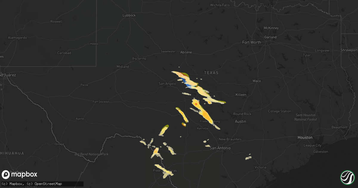
Hail Map in Texas on April 22, 2023
Get this storm
April 22 map
$229
one time, instant access
Download today. No call, no setup
Keep the $229
Bought the map and want the full workflow? Apply the entire $229 to a subscription within 7 days. None of it is wasted.
Every map, not just this one
This buys you this map. Subscription and you get every map we run, in the markets you choose from a few cities to whole states to nationwide. Plus real-time alerts the moment a storm fires.
Contact data
Name, contact info, occupancy, even credit band for addresses in the footprint. You go from where it hit to who to call.
Become the source they trust
Unlimited branding weather history reports on demand. You already have the documented answer ready for the property owner, and you are the one who showed up with it.
Property data and RoofTrace estimates
Pull up any address you have got, its value and the exact code rules for that jurisdiction, straight from One Click Code. Then RoofTrace estimates the squares, pitch, and roof value, priced the way you price.
Storm reports in Texas
Texas
| Date | Description |
|---|---|
| 04/22/20236:44 PM CDT | A local report indicates 1.00 inch wind near 5 W CHEROKEE |
| 04/22/20235:39 PM CDT | A local report indicates 1.25 inch wind near 1 SW ROCHELLE |
| 04/22/20235:31 PM CDT | Likely melted a bit but near ping pong sized hail. |
| 04/22/20235:30 PM CDT | Lots of quarter sized hail. |
| 04/22/20235:20 PM CDT | A local report indicates 1.75 inch wind near ROCHELLE |
| 04/22/20235:12 PM CDT | Trees down in the pear valley area off of county road 504. |
| 04/22/20234:53 PM CDT | A local report indicates 75 MPH wind near 3 WNW DOOLE |
| 04/22/20234:52 PM CDT | Off and on golf ball sized hail. |
| 04/22/20234:48 PM CDT | Tree limbs blown down with hail covering the ground. |
| 04/22/20234:39 PM CDT | Gust measured at the west texas mesonet. |
| 04/22/20234:30 PM CDT | A local report indicates 1.50 inch wind near 4 SW LEADAY |
| 04/22/20233:55 PM CDT | Nickel to golf ball sized hail covering the ground. |
| 04/22/20233:46 PM CDT | A local report indicates 1.75 inch wind near 1 WNW BALLINGER |
| 04/22/20233:40 PM CDT | Baseball to tea cup size hail reported in ballinger. |
| 04/22/20233:17 AM CDT | Golf ball size hail in the val verde park estates east of del rio. Time estimated from radar. |
| 04/22/20233:15 AM CDT | A local report indicates 1.25 inch wind near 1 SSW LAUGHLIN AFB |
| 04/22/20233:12 AM CDT | A local report indicates 1.75 inch wind near 4 SSE DEL RIO |
| 04/21/202310:20 PM CDT | A local report indicates 1.75 inch wind near 3 NNE FREDERICKSBURG |
| 04/21/202310:18 PM CDT | Golf ball size hail near fredericksburg. |
| 04/21/202310:12 PM CDT | Hail covering the ground with largest stones up to half dollar size. |
| 04/21/202310:10 PM CDT | Some hail possibly larger than quarter size. Tents damaged due to wind/hail. |
| 04/21/202310:09 PM CDT | A local report indicates 2.00 inch wind near 5 N FREDERICKSBURG |
| 04/21/202310:03 PM CDT | Hail bigger than golf balls but smaller than tennis ball size. |
| 04/21/20239:59 PM CDT | A local report indicates 1.00 inch wind near 6 NNW FREDERICKSBURG |
| 04/21/20239:46 PM CDT | In addition to the large hail... A decent amount of tree damage in the area as well from possible wind driven hail. |
| 04/21/20239:45 PM CDT | A local report indicates 1.50 inch wind near 5 W JUNCTION |
| 04/21/20239:43 PM CDT | At hill top cafe near intersection of us highway 87 and ranch road 648. Time estimated via radar. |
| 04/21/20239:26 PM CDT | A local report indicates 2.00 inch wind near 5 S LOYAL VALLEY |
| 04/21/20238:37 PM CDT | A local report indicates 1.75 inch wind near MASON |
| 04/21/20238:35 PM CDT | Estimated while driving on hwy 87. |
| 04/21/20238:33 PM CDT | A local report indicates 1.50 inch wind near 4 WSW VALLEY SPRING |
| 04/21/20238:33 PM CDT | Hen egg sized hail reported. |
| 04/21/20237:05 PM CDT | Small hail with some quarters falling on highway 16 south of cherokee. |
All States Impacted by Hail Map on April 22, 2023
Cities Impacted by Hail Map on April 22, 2023
- Fayette, AL
- Bankston, AL
- New Market, AL
- Huntsville, AL
- Ararat, NC
- Siloam, NC
- Pilot Mountain, NC
- Pinnacle, NC
- Westfield, NC
- Mount Airy, NC
- Stuart, VA
- Claudville, VA
- Meadows Of Dan, VA
- Radiant, VA
- Orange, VA
- Oakpark, VA
- Locust Dale, VA
- Rapidan, VA
- Culpeper, VA
- Lumberton, NC
- Bladenboro, NC
- Norton, TX
- Ballinger, TX
- Rowena, TX
- Talpa, TX
- Voss, TX
- Paint Rock, TX
- Millersview, TX
- Gouldbusk, TX
- Doole, TX
- Lohn, TX
- Rockwood, TX
- Eden, TX
- Rochelle, TX
- Santa Anna, TX
- Brady, TX
- Richland Springs, TX
- Mullins, SC
- Pinebluff, NC
- Aberdeen, NC
- Lake Butler, FL
- Dillon, SC
- Marion, SC
- Latta, SC
- Sellers, SC
- Orrum, NC
- Fairmont, NC
- Fayetteville, NC
- Wade, NC
- Bronte, TX
- Evergreen, NC
- Lake City, FL
- Lulu, FL
- Whiteville, NC
- Wallace, SC
- Bennettsville, SC
- Hamer, SC
- Rowland, NC
- San Saba, TX
- Cherry Hill, NJ
- Marlton, NJ
- Mount Laurel, NJ
- Moorestown, NJ
- Maple Shade, NJ
- Riverside, NJ
- Cherokee, TX
- Llano, TX
- Tow, TX
- Burnet, TX
- Mason, TX
- Art, TX
- Pontotoc, TX
- Valley Spring, TX
- Fredericksburg, TX
- Doss, TX
- Callicoon, NY
- Damascus, PA
- Cochecton, NY
- Liberty, NY
- Ferndale, NY
- Conway, SC
- Milanville, PA
- Pond Eddy, NY
- Barryville, NY
- Eldred, NY
- Shohola, PA
- Melvin, TX
- Milford, PA
- Nichols, SC
- Monticello, NY
- Hext, TX
- Galivants Ferry, SC
- Aynor, SC
- Glen Spey, NY
- Highland Lake, NY
- Longs, SC
- Bunnell, FL
- Lackawaxen, PA
- Narrowsburg, NY
- Kenoza Lake, NY
- North Branch, NY
- Hawley, PA
- Jeffersonville, NY
- Roscoe, NY
- Greeley, PA
- Lake Huntington, NY
- Loris, SC
- Jacksonville, FL
- Ormond Beach, FL
- Daytona Beach, FL
- Hortonville, NY
- Bluffton, TX
- Calverton, NY
- Junction, TX
- Voca, TX
- Rocksprings, TX
- Speonk, NY
- Eastport, NY
- Remsenburg, NY
- Westhampton, NY
- East Moriches, NY
- Westhampton Beach, NY
- London, TX
- Kendalia, TX
- Boerne, TX
- Blanco, TX
- Cocoa Beach, FL
- Manorville, NY
- Stonewall, TX
- Brookesmith, TX
- Bangs, TX
- Brownwood, TX
- Del Rio, TX
- Laughlin Afb, TX
- Bandera, TX
- Brackettville, TX
- Comstock, TX
- Camp Wood, TX
- Pipe Creek, TX
- Menard, TX
- Rio Medina, TX
- Hondo, TX
- San Antonio, TX
- Mico, TX
- Harper, TX
- Riverhead, NY
- Quemado, TX
- Sonora, TX
- Eagle Pass, TX
- Winters, TX
- Cuero, TX
- Yorktown, TX
- Westhoff, TX


