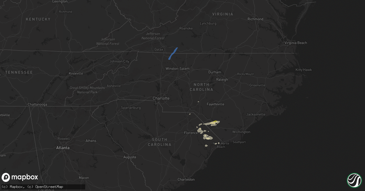
Hail Map in North Carolina on April 22, 2023
Get this storm
April 22 map
$229
one time, instant access
Download today. No call, no setup
Keep the $229
Bought the map and want the full workflow? Apply the entire $229 to a subscription within 7 days. None of it is wasted.
Every map, not just this one
This buys you this map. Subscription and you get every map we run, in the markets you choose from a few cities to whole states to nationwide. Plus real-time alerts the moment a storm fires.
Contact data
Name, contact info, occupancy, even credit band for addresses in the footprint. You go from where it hit to who to call.
Become the source they trust
Unlimited branding weather history reports on demand. You already have the documented answer ready for the property owner, and you are the one who showed up with it.
Property data and RoofTrace estimates
Pull up any address you have got, its value and the exact code rules for that jurisdiction, straight from One Click Code. Then RoofTrace estimates the squares, pitch, and roof value, priced the way you price.
Storm reports in North Carolina
North Carolina
| Date | Description |
|---|---|
| 04/22/20234:20 PM CDT | Tree down on mill branch rd outside of fairmont... Nc. |
| 04/22/20233:57 PM CDT | Tree down on a powerline near n shannon road and adams way. Time estimated by radar. |
| 04/22/20233:30 PM CDT | Tree down on a powerline near the intersection of olivia road and nc-87. Time estimated by radar. |
| 04/22/20233:03 PM CDT | Tree down on a powerline near the intersection of saunders blvd and stephanie street. Time estimated by radar. |
| 04/22/20233:03 PM CDT | Tree down on a powerline near the intersection of saunders blvd and stephanie street. Time estimated by radar. ( |
| 04/22/20232:55 PM CDT | Multiple trees down in aberdeen. Time estimated by radar. |
| 04/22/20232:50 PM CDT | Hail reported near the burnt island community in southeastern robeson county. Pictures were provided via social media measuring around an inch in diameter. |
| 04/22/20232:24 PM CDT | Tree down on clemmer rd and sparks dr. |
| 04/22/20232:15 PM CDT | Tree down at colliers chapel church rd and loop rd. |
| 04/22/202310:28 AM CDT | Tree reported down near the intersection of old greensboro road and crawford dairy road. Time estimated by radar. |
| 04/22/202310:28 AM CDT | Tree down on compton road. Time estimated by radar. |
| 04/22/20239:28 AM CDT | Corrects the time from previous tstm wnd dmg report from 5 wnw schley. Tree down on compton road. Time estimated by radar. |
| 04/22/20239:28 AM CDT | Corrects time from report 4 ssw teer. Tree reported down near the intersection of old greensboro road and crawford dairy road. Time estimated by radar. |
| 04/22/20239:08 AM CDT | Tree down near monroe holt road. Time estimated by radar. |
| 04/22/20238:40 AM CDT | Tree down near the intersection of 22 south and parks crossroads church road. Time estimated by radar. |
| 04/22/20238:16 AM CDT | Tree down on i-73 near the level cross exit. Time estimated by radar. |
| 04/22/20238:07 AM CDT | Power outage caused by fallen trees damaging equipment. Time estimated by radar. |
| 04/22/20238:00 AM CDT | Tree in the roadway on columbus ave at main st in archdale. Reported via social media. |
| 04/21/20238:59 PM CDT | Delayed report. Peak gust measured at the beaufort cwop station on the core banks. Time estimated based on radar. |
| 04/21/20238:59 PM CDT | Corrects previous tstm wnd gst report from 4 se davis. The report event type should have been a marine thunderstorm wind gust. Delayed report. Peak gust measured at the |
| 04/21/20237:43 PM CDT | Delayed report. Tree damage and damage to a large shed and carport were reported near the intersection of highway 41 and country lane. Time estimated based on radar. |
| 04/21/20237:08 PM CDT | Damage to outbuildings and roof damage to one business in richlands. |
| 04/21/20237:01 PM CDT | Tree and property damage. |
All States Impacted by Hail Map on April 22, 2023
Cities Impacted by Hail Map on April 22, 2023
- Fayette, AL
- Bankston, AL
- New Market, AL
- Huntsville, AL
- Ararat, NC
- Siloam, NC
- Pilot Mountain, NC
- Pinnacle, NC
- Westfield, NC
- Mount Airy, NC
- Stuart, VA
- Claudville, VA
- Meadows Of Dan, VA
- Radiant, VA
- Orange, VA
- Oakpark, VA
- Locust Dale, VA
- Rapidan, VA
- Culpeper, VA
- Lumberton, NC
- Bladenboro, NC
- Norton, TX
- Ballinger, TX
- Rowena, TX
- Talpa, TX
- Voss, TX
- Paint Rock, TX
- Millersview, TX
- Gouldbusk, TX
- Doole, TX
- Lohn, TX
- Rockwood, TX
- Eden, TX
- Rochelle, TX
- Santa Anna, TX
- Brady, TX
- Richland Springs, TX
- Mullins, SC
- Pinebluff, NC
- Aberdeen, NC
- Lake Butler, FL
- Dillon, SC
- Marion, SC
- Latta, SC
- Sellers, SC
- Orrum, NC
- Fairmont, NC
- Fayetteville, NC
- Wade, NC
- Bronte, TX
- Evergreen, NC
- Lake City, FL
- Lulu, FL
- Whiteville, NC
- Wallace, SC
- Bennettsville, SC
- Hamer, SC
- Rowland, NC
- San Saba, TX
- Cherry Hill, NJ
- Marlton, NJ
- Mount Laurel, NJ
- Moorestown, NJ
- Maple Shade, NJ
- Riverside, NJ
- Cherokee, TX
- Llano, TX
- Tow, TX
- Burnet, TX
- Mason, TX
- Art, TX
- Pontotoc, TX
- Valley Spring, TX
- Fredericksburg, TX
- Doss, TX
- Callicoon, NY
- Damascus, PA
- Cochecton, NY
- Liberty, NY
- Ferndale, NY
- Conway, SC
- Milanville, PA
- Pond Eddy, NY
- Barryville, NY
- Eldred, NY
- Shohola, PA
- Melvin, TX
- Milford, PA
- Nichols, SC
- Monticello, NY
- Hext, TX
- Galivants Ferry, SC
- Aynor, SC
- Glen Spey, NY
- Highland Lake, NY
- Longs, SC
- Bunnell, FL
- Lackawaxen, PA
- Narrowsburg, NY
- Kenoza Lake, NY
- North Branch, NY
- Hawley, PA
- Jeffersonville, NY
- Roscoe, NY
- Greeley, PA
- Lake Huntington, NY
- Loris, SC
- Jacksonville, FL
- Ormond Beach, FL
- Daytona Beach, FL
- Hortonville, NY
- Bluffton, TX
- Calverton, NY
- Junction, TX
- Voca, TX
- Rocksprings, TX
- Speonk, NY
- Eastport, NY
- Remsenburg, NY
- Westhampton, NY
- East Moriches, NY
- Westhampton Beach, NY
- London, TX
- Kendalia, TX
- Boerne, TX
- Blanco, TX
- Cocoa Beach, FL
- Manorville, NY
- Stonewall, TX
- Brookesmith, TX
- Bangs, TX
- Brownwood, TX
- Del Rio, TX
- Laughlin Afb, TX
- Bandera, TX
- Brackettville, TX
- Comstock, TX
- Camp Wood, TX
- Pipe Creek, TX
- Menard, TX
- Rio Medina, TX
- Hondo, TX
- San Antonio, TX
- Mico, TX
- Harper, TX
- Riverhead, NY
- Quemado, TX
- Sonora, TX
- Eagle Pass, TX
- Winters, TX
- Cuero, TX
- Yorktown, TX
- Westhoff, TX


