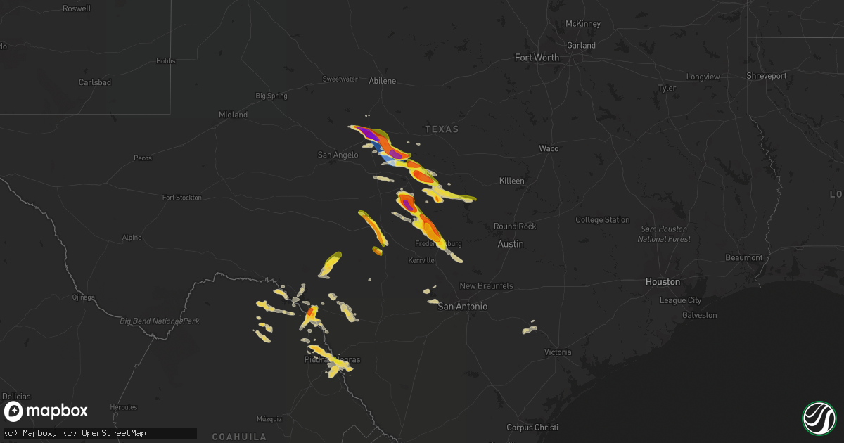
Hail Map on April 22, 2023
Get this storm
April 22 map
$229
one time, instant access
Download today. No call, no setup
Keep the $229
Bought the map and want the full workflow? Apply the entire $229 to a subscription within 7 days. None of it is wasted.
Every map, not just this one
This buys you this map. Subscription and you get every map we run, in the markets you choose from a few cities to whole states to nationwide. Plus real-time alerts the moment a storm fires.
Contact data
Name, contact info, occupancy, even credit band for addresses in the footprint. You go from where it hit to who to call.
Become the source they trust
Unlimited branding weather history reports on demand. You already have the documented answer ready for the property owner, and you are the one who showed up with it.
Property data and RoofTrace estimates
Pull up any address you have got, its value and the exact code rules for that jurisdiction, straight from One Click Code. Then RoofTrace estimates the squares, pitch, and roof value, priced the way you price.
States Impacted by Hail Map on April 22, 2023
Storm reports
South Carolina
| Date | Description |
|---|---|
| 04/22/20235:25 PM CDT | Large tree down across road near main st and red bluff rd in loris. Time estimated via radar. |
| 04/22/20234:40 PM CDT | Co-op observer reported hail with a size between a dime and a quarter. The maximum size reported was around one inch. Hail occurred yesterday afternoon near mullins... |
| 04/22/20234:25 PM CDT | Quarter size hail in temperance hill area. |
| 04/22/20234:10 PM CDT | *** 1 inj *** several trees down on w. Main street in dillon. A man was pinned under tree limbs and was taken to the hospital. |
North Carolina
| Date | Description |
|---|---|
| 04/22/20234:20 PM CDT | Tree down on mill branch rd outside of fairmont... Nc. |
| 04/22/20233:57 PM CDT | Tree down on a powerline near n shannon road and adams way. Time estimated by radar. |
| 04/22/20233:30 PM CDT | Tree down on a powerline near the intersection of olivia road and nc-87. Time estimated by radar. |
| 04/22/20233:03 PM CDT | Tree down on a powerline near the intersection of saunders blvd and stephanie street. Time estimated by radar. ( |
| 04/22/20233:03 PM CDT | Tree down on a powerline near the intersection of saunders blvd and stephanie street. Time estimated by radar. |
| 04/22/20232:55 PM CDT | Multiple trees down in aberdeen. Time estimated by radar. |
| 04/22/20232:50 PM CDT | Hail reported near the burnt island community in southeastern robeson county. Pictures were provided via social media measuring around an inch in diameter. |
| 04/22/20232:24 PM CDT | Tree down on clemmer rd and sparks dr. |
| 04/22/20232:15 PM CDT | Tree down at colliers chapel church rd and loop rd. |
| 04/22/202310:28 AM CDT | Tree down on compton road. Time estimated by radar. |
| 04/22/202310:28 AM CDT | Tree reported down near the intersection of old greensboro road and crawford dairy road. Time estimated by radar. |
| 04/22/20239:28 AM CDT | Corrects time from report 4 ssw teer. Tree reported down near the intersection of old greensboro road and crawford dairy road. Time estimated by radar. |
| 04/22/20239:28 AM CDT | Corrects the time from previous tstm wnd dmg report from 5 wnw schley. Tree down on compton road. Time estimated by radar. |
| 04/22/20239:08 AM CDT | Tree down near monroe holt road. Time estimated by radar. |
| 04/22/20238:40 AM CDT | Tree down near the intersection of 22 south and parks crossroads church road. Time estimated by radar. |
| 04/22/20238:16 AM CDT | Tree down on i-73 near the level cross exit. Time estimated by radar. |
| 04/22/20238:07 AM CDT | Power outage caused by fallen trees damaging equipment. Time estimated by radar. |
| 04/22/20238:00 AM CDT | Tree in the roadway on columbus ave at main st in archdale. Reported via social media. |
| 04/21/20238:59 PM CDT | Corrects previous tstm wnd gst report from 4 se davis. The report event type should have been a marine thunderstorm wind gust. Delayed report. Peak gust measured at the |
| 04/21/20238:59 PM CDT | Delayed report. Peak gust measured at the beaufort cwop station on the core banks. Time estimated based on radar. |
| 04/21/20237:43 PM CDT | Delayed report. Tree damage and damage to a large shed and carport were reported near the intersection of highway 41 and country lane. Time estimated based on radar. |
| 04/21/20237:08 PM CDT | Damage to outbuildings and roof damage to one business in richlands. |
| 04/21/20237:01 PM CDT | Tree and property damage. |
Rhode Island
| Date | Description |
|---|---|
| 04/22/20231:05 AM CDT | Member of the public relayed via social media that hail up to quarter size with frequent lightning had occurred in westerly... Ri. Relayed by amateur radio. |
Texas
| Date | Description |
|---|---|
| 04/22/20236:44 PM CDT | A local report indicates 1.00 inch wind near 5 W CHEROKEE |
| 04/22/20235:39 PM CDT | A local report indicates 1.25 inch wind near 1 SW ROCHELLE |
| 04/22/20235:31 PM CDT | Likely melted a bit but near ping pong sized hail. |
| 04/22/20235:30 PM CDT | Lots of quarter sized hail. |
| 04/22/20235:20 PM CDT | A local report indicates 1.75 inch wind near ROCHELLE |
| 04/22/20235:12 PM CDT | Trees down in the pear valley area off of county road 504. |
| 04/22/20234:53 PM CDT | A local report indicates 75 MPH wind near 3 WNW DOOLE |
| 04/22/20234:52 PM CDT | Off and on golf ball sized hail. |
| 04/22/20234:48 PM CDT | Tree limbs blown down with hail covering the ground. |
| 04/22/20234:39 PM CDT | Gust measured at the west texas mesonet. |
| 04/22/20234:30 PM CDT | A local report indicates 1.50 inch wind near 4 SW LEADAY |
| 04/22/20233:55 PM CDT | Nickel to golf ball sized hail covering the ground. |
| 04/22/20233:46 PM CDT | A local report indicates 1.75 inch wind near 1 WNW BALLINGER |
| 04/22/20233:40 PM CDT | Baseball to tea cup size hail reported in ballinger. |
| 04/22/20233:17 AM CDT | Golf ball size hail in the val verde park estates east of del rio. Time estimated from radar. |
| 04/22/20233:15 AM CDT | A local report indicates 1.25 inch wind near 1 SSW LAUGHLIN AFB |
| 04/22/20233:12 AM CDT | A local report indicates 1.75 inch wind near 4 SSE DEL RIO |
| 04/21/202310:20 PM CDT | A local report indicates 1.75 inch wind near 3 NNE FREDERICKSBURG |
| 04/21/202310:18 PM CDT | Golf ball size hail near fredericksburg. |
| 04/21/202310:12 PM CDT | Hail covering the ground with largest stones up to half dollar size. |
| 04/21/202310:10 PM CDT | Some hail possibly larger than quarter size. Tents damaged due to wind/hail. |
| 04/21/202310:09 PM CDT | A local report indicates 2.00 inch wind near 5 N FREDERICKSBURG |
| 04/21/202310:03 PM CDT | Hail bigger than golf balls but smaller than tennis ball size. |
| 04/21/20239:59 PM CDT | A local report indicates 1.00 inch wind near 6 NNW FREDERICKSBURG |
| 04/21/20239:46 PM CDT | In addition to the large hail... A decent amount of tree damage in the area as well from possible wind driven hail. |
| 04/21/20239:45 PM CDT | A local report indicates 1.50 inch wind near 5 W JUNCTION |
| 04/21/20239:43 PM CDT | At hill top cafe near intersection of us highway 87 and ranch road 648. Time estimated via radar. |
| 04/21/20239:26 PM CDT | A local report indicates 2.00 inch wind near 5 S LOYAL VALLEY |
| 04/21/20238:37 PM CDT | A local report indicates 1.75 inch wind near MASON |
| 04/21/20238:35 PM CDT | Estimated while driving on hwy 87. |
| 04/21/20238:33 PM CDT | Hen egg sized hail reported. |
| 04/21/20238:33 PM CDT | A local report indicates 1.50 inch wind near 4 WSW VALLEY SPRING |
| 04/21/20237:05 PM CDT | Small hail with some quarters falling on highway 16 south of cherokee. |
New York
| Date | Description |
|---|---|
| 04/22/20236:30 PM CDT | Tree down with photo sent to broadcast media. |
| 04/22/20236:01 PM CDT | Via social media. Public reported to nws of trees down on state police barracks. Radar-estimated time. |
| 04/22/20236:00 PM CDT | Downed trees and wires. Possible other damage but still being assessed. Radar-estimated time. |
| 04/22/20236:00 PM CDT | Trees and wires down in watson. |
| 04/22/20235:58 PM CDT | Trees and wires down. |
| 04/22/20235:57 PM CDT | Trees and wires down. |
| 04/22/20235:50 PM CDT | Trees and wires down on road. |
| 04/22/20235:50 PM CDT | 2 barns heavily damaged. |
| 04/22/20235:50 PM CDT | Trees and wires down on road. |
| 04/22/20235:47 PM CDT | Damage to house caused occupants to be trapped. Occupant said it was a tornado. |
| 04/22/20235:47 PM CDT | Trees and wires down in the road. |
| 04/22/20235:40 PM CDT | Tree and wires down. |
| 04/22/20235:40 PM CDT | Multiple trees and wires down... As well as broken power poles... In vicinity of main street and maple. Radar-estimated time. |
| 04/22/20235:39 PM CDT | Golf ball sized hail. Along miller road. Radar-estimated time. |
| 04/22/20235:30 PM CDT | Multiple trees down on house. |
| 04/22/20235:30 PM CDT | Corrects previous tstm wnd dmg report from 1 e bethel. Multiple trees down on house. |
| 04/22/20233:40 PM CDT | Tree down on road. Transformer and wires also knocked down. |
Maryland
| Date | Description |
|---|---|
| 04/22/20232:53 PM CDT | A tree down was reported near cirelli court and md-715. |
| 04/22/20232:35 PM CDT | A tree down on powerlines was reported near e wheel rd and cedar ln. |
| 04/22/20232:29 PM CDT | A tree down was reported near the 900 block of magnolia rd and md-152. |
| 04/22/20232:22 PM CDT | Multiple trees down and roof damage reported in fallston. |
| 04/22/20232:16 PM CDT | A tree down was reported near freeland rd and heathcote rd. |
| 04/22/20232:09 PM CDT | Shingles blown off... Trampoline tossed into a fence... And power pole downed |
| 04/22/20232:07 PM CDT | A tree down was reported on seminary ave. |
| 04/22/20232:04 PM CDT | A tree down was reported near the 4200 block of furley ave. |
| 04/22/20232:02 PM CDT | A tree down was reported near belair road and clifton park terrace. |
| 04/22/20232:00 PM CDT | A downed tree onto a house was reported near the 700 block of seminary dr. |
| 04/22/20232:00 PM CDT | Tree down on south washington st. Corrected to include remarks. |
| 04/22/20231:59 PM CDT | Large tree branch snapped and downed; radar estimated time. |
| 04/22/20231:57 PM CDT | A tree down was reported on mount zion rd. |
| 04/22/20231:57 PM CDT | A tree down reported near 200 block of w baltimore st. |
| 04/22/20231:47 PM CDT | A tree down on powerlines was reported near the 2700 block of kays mill rd. |
| 04/22/20231:36 PM CDT | A tree down on powerlines was reported near the 2500 block of keysville frederick co rd. |
| 04/22/20231:36 PM CDT | A tree down was reported near the 9400 block of north penfield rd. |
| 04/22/20231:22 PM CDT | Three reports of trees and powerlines down near landover. |
| 04/22/20231:07 PM CDT | Three trees reported down in la plata. |
| 04/22/20231:05 PM CDT | A tree down was reported near old bucklodge lane and bucklodge rd. |
| 04/22/20231:03 PM CDT | Wires and tree branches down near 14811 pettit way |
| 04/22/20231:02 PM CDT | A tree down was reported near little falls parkway |
| 04/22/202312:59 PM CDT | Multiple trees snapped and uprooted. One tree impacted a home. Fence blown over. |
| 04/22/202312:58 PM CDT | Ef0 tornado touched down for around a minute... With 75 mph winds... 100 yard path length... And 25 yard path width along dowden circle near stevens park. There were tw |
Virginia
| Date | Description |
|---|---|
| 04/22/20232:15 PM CDT | Trees down on scott factory rd near turner rd. |
| 04/22/20231:42 PM CDT | A tree down on powerlines was reported near old bridge rd and gordon blvd. |
| 04/22/202312:54 PM CDT | A tree down was reported near old chesterbrook rd and 6th place. |
| 04/22/202312:05 PM CDT | Large tree down near intersection of kennedy rd and greenwich rd |
| 04/22/202311:50 AM CDT | Large tree down onto power lines near intersection of silver hill rd and royalls mill rd |
| 04/22/202311:50 AM CDT | Tree down on road along viewtown rd |
| 04/22/202311:40 AM CDT | A tree fell onto a vehcile along dutch hollow road |
| 04/22/202311:33 AM CDT | Multiple trees down at intersection of norman rd and north merrimac rd |
| 04/22/202311:32 AM CDT | Trees down along gibson mill road. |
| 04/22/202311:27 AM CDT | Tree and wires down on the 18000 block of south merrimac rd |
| 04/22/20239:55 AM CDT | Thunderstorm winds blew down one tree at the intersection of old courthouse road and hollywood road. |
| 04/22/20238:26 AM CDT | Thunderstorm winds blew down one tree along goodview road. |
| 04/22/20238:25 AM CDT | Thunderstorm winds blew down one tree along wilderness way. |
| 04/22/20238:25 AM CDT | Thunderstorm winds blew down one tree along horseshoe bend road. |
| 04/22/20238:25 AM CDT | Thunderstorm winds blew down one tree along wilderness way. Time was corrected to 925 am. |
| 04/22/20238:05 AM CDT | Thunderstorm winds blew down several trees in wirtz. |
| 04/22/20237:57 AM CDT | Thunderstorm winds blew down one tree along the 100 block of ramble road close to the intersection of patsy avenue. |
| 04/22/20237:54 AM CDT | Thunderstorm winds blew down one tree along the 1100 block of horsepasture price road between ziglar road and bouldin road. |
| 04/22/20237:45 AM CDT | Thunderstorm winds blew down one tree at the intersection of crestview drive and blackberry road. |
| 04/22/20237:25 AM CDT | Thunderstorm winds blew down one tree along wilderness way. |
Pennsylvania
| Date | Description |
|---|---|
| 04/22/20236:05 PM CDT | Utility wires down in dingman township to milford areas... Along i-84 corridor. Radar-estimated time. |
| 04/22/20235:59 PM CDT | Utility wires down. Radar-estimated time. |
| 04/22/20235:08 PM CDT | Downed trees into wires on belfast road. Time estimated via radar. |
| 04/22/20234:03 PM CDT | Pennsylvania em reports downed wires on summit hill borough. Pa 902 is closed from white bear drive to mahoning drive. Time estimated via radar. |
| 04/22/20233:54 PM CDT | Report of roof damage around the lehighton area. Spotter estimated gusts to around 60 mph. Time estimated via radar. |
| 04/22/20233:45 PM CDT | Two trees down and damage to a greenhouse. |
| 04/22/20233:35 PM CDT | Report from mping: 3-inch tree limbs broken; power poles broken. Time estimated from radar. |
| 04/22/20233:35 PM CDT | Tree down and also damage to a gazebo. |
| 04/22/20233:21 PM CDT | Corrects previous tstm wnd dmg report from womelsdorf. Womelsdorf pd reported trees and power lines down in a swath from the elementary school to near the intersection |
| 04/22/20233:21 PM CDT | Womelsdorf pd reported trees and power lines down from the thunderstorm. Time estimated based on radar. |
| 04/22/20233:20 PM CDT | Tree on a house. |
| 04/22/20232:45 PM CDT | *** 1 fatal *** one fatality due to a falling branch. |
| 04/22/20232:45 PM CDT | Tree down on a house. |
| 04/22/20232:45 PM CDT | Tree on a car... Time estimated by radar. |
| 04/22/20232:42 PM CDT | Trees and wires down. |
| 04/22/20232:42 PM CDT | Tree on a house. |
| 04/22/20232:40 PM CDT | Tree down on a house. |
| 04/22/20232:37 PM CDT | 10-12 trees uprooted. |
| 04/22/20232:37 PM CDT | Several trees down on burkholder rd. |
| 04/22/20232:37 PM CDT | Two pine trees blown over... One oak tree uprooted with a 12 ft root ball. |
| 04/22/20232:36 PM CDT | Tree and wires down. |
| 04/22/20232:36 PM CDT | Tree down on a house... Time estimate by radar. |
| 04/22/20232:20 PM CDT | Tree limbs and power lines down over susquehanna trail south... Time estimated by radar. |
| 04/22/20231:50 PM CDT | Tree on a house on hill church rd. |
| 04/22/20231:49 PM CDT | Tree down on house... Time estimated by radar. |
| 04/22/20231:49 PM CDT | Tree and siding damage in derry township... Time estimated by radar. |
| 04/22/20231:47 PM CDT | Two large trees down and power line down in a yard. Report relayed by twitter... Time estimated by radar. |
| 04/22/20231:45 PM CDT | Tree fell across and onto a road. Time estimated by radar. |
| 04/22/20231:45 PM CDT | 5 utility poles down from rosedale ave to meade ave. |
| 04/22/20231:45 PM CDT | Half of a barn roof tore off... Several trees down in the vicinity of areba ave and hillview ln. |
New Jersey
| Date | Description |
|---|---|
| 04/22/20236:10 PM CDT | A local report indicates 1.00 inch wind near 1 SE BRIDGEBORO |
| 04/22/20236:01 PM CDT | A local report indicates 1.00 inch wind near MOORESTOWN |
| 04/22/20235:59 PM CDT | Report of wires down at intersection of hartford road and marne highway. Time estimated via radar. |
| 04/22/20235:55 PM CDT | Quarter size hail on i-295 between exits 64 and 66. Time estimated via radar. |
| 04/22/20235:51 PM CDT | A local report indicates 1.00 inch wind near CHERRY HILL |
| 04/21/20237:40 PM CDT | Quarter sized hail observed in west milford. |
| 04/21/20237:03 PM CDT | A local report indicates 1.00 inch wind near RANDOLPH |
Florida
| Date | Description |
|---|---|
| 04/22/20233:45 PM CDT | Tree down over sr-100w near county line. |
District of Columbia
| Date | Description |
|---|---|
| 04/22/20231:03 PM CDT | A tree down was reported near the 4500 block of fessenden st. |
Cities Impacted by Hail Map on April 22, 2023
- Fayette, AL
- Bankston, AL
- New Market, AL
- Huntsville, AL
- Ararat, NC
- Siloam, NC
- Pilot Mountain, NC
- Pinnacle, NC
- Westfield, NC
- Mount Airy, NC
- Stuart, VA
- Claudville, VA
- Meadows Of Dan, VA
- Radiant, VA
- Orange, VA
- Oakpark, VA
- Locust Dale, VA
- Rapidan, VA
- Culpeper, VA
- Lumberton, NC
- Bladenboro, NC
- Norton, TX
- Ballinger, TX
- Rowena, TX
- Talpa, TX
- Voss, TX
- Paint Rock, TX
- Millersview, TX
- Gouldbusk, TX
- Doole, TX
- Lohn, TX
- Rockwood, TX
- Eden, TX
- Rochelle, TX
- Santa Anna, TX
- Brady, TX
- Richland Springs, TX
- Mullins, SC
- Pinebluff, NC
- Aberdeen, NC
- Lake Butler, FL
- Dillon, SC
- Marion, SC
- Latta, SC
- Sellers, SC
- Orrum, NC
- Fairmont, NC
- Fayetteville, NC
- Wade, NC
- Bronte, TX
- Evergreen, NC
- Lake City, FL
- Lulu, FL
- Whiteville, NC
- Wallace, SC
- Bennettsville, SC
- Hamer, SC
- Rowland, NC
- San Saba, TX
- Cherry Hill, NJ
- Marlton, NJ
- Mount Laurel, NJ
- Moorestown, NJ
- Maple Shade, NJ
- Riverside, NJ
- Cherokee, TX
- Llano, TX
- Tow, TX
- Burnet, TX
- Mason, TX
- Art, TX
- Pontotoc, TX
- Valley Spring, TX
- Fredericksburg, TX
- Doss, TX
- Callicoon, NY
- Damascus, PA
- Cochecton, NY
- Liberty, NY
- Ferndale, NY
- Conway, SC
- Milanville, PA
- Pond Eddy, NY
- Barryville, NY
- Eldred, NY
- Shohola, PA
- Melvin, TX
- Milford, PA
- Nichols, SC
- Monticello, NY
- Hext, TX
- Galivants Ferry, SC
- Aynor, SC
- Glen Spey, NY
- Highland Lake, NY
- Longs, SC
- Bunnell, FL
- Lackawaxen, PA
- Narrowsburg, NY
- Kenoza Lake, NY
- North Branch, NY
- Hawley, PA
- Jeffersonville, NY
- Roscoe, NY
- Greeley, PA
- Lake Huntington, NY
- Loris, SC
- Jacksonville, FL
- Ormond Beach, FL
- Daytona Beach, FL
- Hortonville, NY
- Bluffton, TX
- Calverton, NY
- Junction, TX
- Voca, TX
- Rocksprings, TX
- Speonk, NY
- Eastport, NY
- Remsenburg, NY
- Westhampton, NY
- East Moriches, NY
- Westhampton Beach, NY
- London, TX
- Kendalia, TX
- Boerne, TX
- Blanco, TX
- Cocoa Beach, FL
- Manorville, NY
- Stonewall, TX
- Brookesmith, TX
- Bangs, TX
- Brownwood, TX
- Del Rio, TX
- Laughlin Afb, TX
- Bandera, TX
- Brackettville, TX
- Comstock, TX
- Camp Wood, TX
- Pipe Creek, TX
- Menard, TX
- Rio Medina, TX
- Hondo, TX
- San Antonio, TX
- Mico, TX
- Harper, TX
- Riverhead, NY
- Quemado, TX
- Sonora, TX
- Eagle Pass, TX
- Winters, TX
- Cuero, TX
- Yorktown, TX
- Westhoff, TX