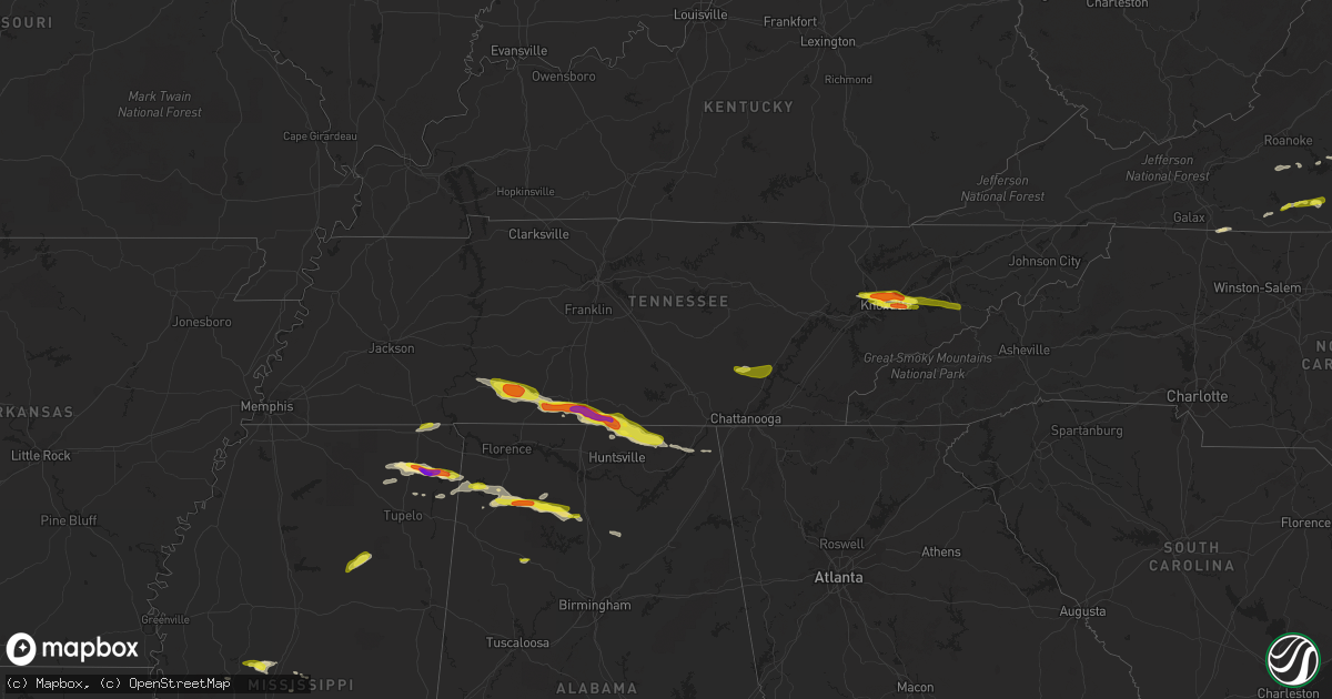
Hail Map in Tennessee on April 22, 2017
Get this storm
April 22 map
$229
one time, instant access
Download today. No call, no setup
Keep the $229
Bought the map and want the full workflow? Apply the entire $229 to a subscription within 7 days. None of it is wasted.
Every map, not just this one
This buys you this map. Subscription and you get every map we run, in the markets you choose from a few cities to whole states to nationwide. Plus real-time alerts the moment a storm fires.
Contact data
Name, contact info, occupancy, even credit band for addresses in the footprint. You go from where it hit to who to call.
Become the source they trust
Unlimited branding weather history reports on demand. You already have the documented answer ready for the property owner, and you are the one who showed up with it.
Property data and RoofTrace estimates
Pull up any address you have got, its value and the exact code rules for that jurisdiction, straight from One Click Code. Then RoofTrace estimates the squares, pitch, and roof value, priced the way you price.
Storm reports in Tennessee
Tennessee
| Date | Description |
|---|---|
| 04/22/20175:48 PM CDT | Numerous trees down across the county. |
| 04/22/20175:35 PM CDT | A few trees down around the county. |
| 04/22/20175:30 PM CDT | Multiple trees and power lines down across the northwest portion of hamilton county. Nine houses damaged. |
| 04/22/20175:18 PM CDT | Several trees down across southern end of rhea county. |
| 04/22/20175:18 PM CDT | Tree down on a home in sale creek. |
| 04/22/20175:15 PM CDT | A local report indicates 1.00 inch wind near 3 SE DANDRIDGE |
| 04/22/20175:00 PM CDT | A local report indicates 1.25 inch wind near 12 SW FAYETTEVILLE |
| 04/22/20174:50 PM CDT | Canopy above gas station blown off. |
| 04/22/20174:50 PM CDT | Large tree down. |
| 04/22/20174:50 PM CDT | Screens knocked out of homes. |
| 04/22/20174:45 PM CDT | A local report indicates 1.00 inch wind near 13 SW FAYETTEVILLE |
| 04/22/20174:40 PM CDT | A local report indicates 1.00 inch wind near 13 SW FAYETTEVILLE |
| 04/22/20174:35 PM CDT | A few trees down around the strawberry plains area and south near i-40. |
| 04/22/20174:25 PM CDT | Several reports of golfball size hail in and around knoxville. Reports from fb and twitter with pictures. |
| 04/22/20174:25 PM CDT | Relayed via whnt in huntsville |
| 04/22/20174:25 PM CDT | Photos showed hail covered i-65 from mile marker 7 to mile marker 9 |
| 04/22/20174:22 PM CDT | A local report indicates 1.00 inch wind near 4 N KNOXVILLE |
| 04/22/20174:17 PM CDT | Two trees blown over...including one large rootball. Time estimated based on radar. |
| 04/22/20174:09 PM CDT | Quarter hail covering the ground in goodspring |
| 04/22/20173:59 PM CDT | Large tree down blocking spencer mill road at east side drive. Time estimated based on radar. |
| 04/22/20173:45 PM CDT | 18-inch diameter trees down at revilo road and fall river road |
| 04/22/20173:25 PM CDT | Tree down on busby road near moore cut off road in westpoint |
| 04/22/20173:11 PM CDT | Large tree uprooted across old hog creek road and fell onto business |
| 04/22/20173:11 PM CDT | Trees down and a funnel cloud spotted |
All States Impacted by Hail Map on April 22, 2017
Cities Impacted by Hail Map on April 22, 2017
- Yale, VA
- Jarratt, VA
- Capron, VA
- Drewryville, VA
- Emporia, VA
- Stony Creek, VA
- Hazel Green, AL
- Toney, AL
- Wiggins, MS
- Lumberton, MS
- New Market, AL
- Cullman, AL
- Vinemont, AL
- Hackleburg, AL
- Hodges, AL
- Columbia, MS
- Gurley, AL
- Scottsboro, AL
- Goodspring, TN
- Taft, TN
- Waynesboro, TN
- Estillfork, AL
- Leoma, TN
- Princeton, AL
- Collinwood, TN
- Ardmore, AL
- Pulaski, TN
- Prospect, TN
- Westpoint, TN
- Meridianville, AL
- Flintville, TN
- Fayetteville, TN
- Lawrenceburg, TN
- Hollytree, AL
- Ardmore, TN
- Dellrose, TN
- Decatur, MS
- Conehatta, MS
- Phil Campbell, AL
- Tishomingo, MS
- Marietta, MS
- Dumas, MS
- Dennis, MS
- Belmont, MS
- Ripley, MS
- New Site, MS
- Baldwyn, MS
- Booneville, MS
- Knoxville, TN
- Bracey, VA
- Monticello, MS
- Brookhaven, MS
- Sontag, MS
- Gates, NC
- Suffolk, VA
- Houston, MS
- Vardaman, MS
- Jayess, MS
- Durant, MS
- Murfreesboro, NC
- Como, NC
- Pendleton, NC
- Ridgeland, MS
- Powell, TN
- Freeman, VA
- Lawrenceville, VA
- Union, MS
- Lexington, MS
- Lena, MS
- Sallis, MS
- Garysburg, NC
- Margarettsville, NC
- Corapeake, NC
- Seaboard, NC
- Conway, NC
- Jackson, NC
- Canton, MS
- Meridian, MS
- Loretto, TN
- Fackler, AL
- Clifton, TN
- Heidelberg, MS
- Moneta, VA
- Townley, AL
- Carbon Hill, AL
- Minor Hill, TN
- Ararat, VA
- Claudville, VA
- Mount Airy, NC
- Cana, VA
- Lake, MS
- Little Rock, MS
- Red Oak, VA
- South Hill, VA
- Baskerville, VA
- Clarksville, VA
- La Crosse, VA
- Skipwith, VA
- Chase City, VA
- Boydton, VA
- Brodnax, VA
- Houston, AL
- Addison, AL
- Danville, AL
- Russellville, AL
- Moulton, AL
- Hickory, MS
- Chunky, MS
- Red Bay, AL
- Lottie, LA
- Sale Creek, TN
- Vina, AL
- Gladys, VA
- Altavista, VA
- Marion, MS
- Randolph, VA
- Rocky Mount, VA
- Boones Mill, VA
- Callaway, VA
- Burnsville, MS
- Corinth, MS
- Michie, TN
- Axton, VA
- Callands, VA
- Haleyville, AL
- Golden, MS
- Spruce Pine, AL
- Yazoo City, MS
- Seymour, TN
- Clinton, TN
- Strawberry Plains, TN
- Sevierville, TN
- Kodak, TN
- Denham Springs, LA
- Walker, LA
- Oak Vale, MS
- Fulton, MS
- Hurt, VA
- Dandridge, TN
- Hermanville, MS
- Dunlap, TN
- Ruth, MS
- Bedford, VA
- Huddleston, VA
- Lynch Station, VA
- Oak Ridge, TN
- Pickens, MS
- Flat Rock, AL
- Stanleytown, VA
- Martinsville, VA
- Fieldale, VA
- Collinsville, VA
- Bassett, VA
- Livingston, LA
- Raleigh, MS
- Glade Hill, VA
- Seminary, MS
- Guntown, MS
- Buffalo Junction, VA
- Virgilina, VA
- Hollywood, AL
- Stevenson, AL
- Perkinston, MS
- Blountsville, AL
- Hanceville, AL
- Philadelphia, MS
- Poplarville, MS
- De Berry, TX
- Sunbury, NC
- Camden, MS
- Kosciusko, MS
- New Albany, MS
- Jackson, MS
- South Mills, NC
- Calhoun City, MS
- Eure, NC
- Ahoskie, NC
- Winton, NC
- Patrick Springs, VA
- Madison, MS
- Newport, TN
- New Market, TN
- Chatham, VA
- Brookneal, VA
- Clover, VA
- Nathalie, VA
- Elora, TN
- Dayton, TN
- Soddy Daisy, TN
- Graysville, TN
- Kilgore, TX
- Longview, TX
- Gladewater, TX


