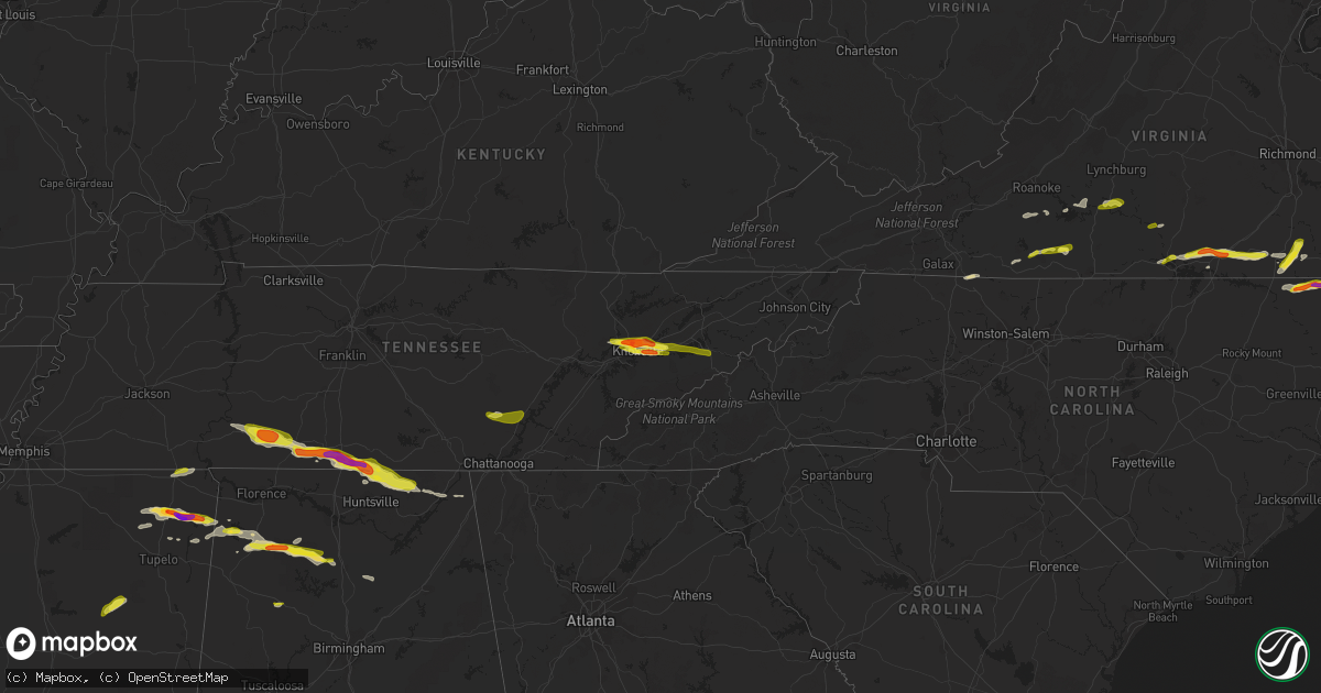
Hail Map on April 22, 2017
Get this storm
April 22 map
$229
one time, instant access
Download today. No call, no setup
Keep the $229
Bought the map and want the full workflow? Apply the entire $229 to a subscription within 7 days. None of it is wasted.
Every map, not just this one
This buys you this map. Subscription and you get every map we run, in the markets you choose from a few cities to whole states to nationwide. Plus real-time alerts the moment a storm fires.
Contact data
Name, contact info, occupancy, even credit band for addresses in the footprint. You go from where it hit to who to call.
Become the source they trust
Unlimited branding weather history reports on demand. You already have the documented answer ready for the property owner, and you are the one who showed up with it.
Property data and RoofTrace estimates
Pull up any address you have got, its value and the exact code rules for that jurisdiction, straight from One Click Code. Then RoofTrace estimates the squares, pitch, and roof value, priced the way you price.
States Impacted by Hail Map on April 22, 2017
Storm reports
Mississippi
| Date | Description |
|---|---|
| 04/22/20176:58 PM CDT | Tree down across hwy 18. |
| 04/22/20176:53 PM CDT | Trees down in sylvarena. |
| 04/22/20176:35 PM CDT | Tree downed on county road 451. |
| 04/22/20176:30 PM CDT | A few trees down in the northeast portion of clarke county along hwy 514. |
| 04/22/20176:20 PM CDT | Numerous trees down across southeastern lauderdale county. |
| 04/22/20175:50 PM CDT | Trees down along briarwood road near northeast high school. |
| 04/22/20175:45 PM CDT | Dozens of trees and power lines blown down across meridian. |
| 04/22/20175:43 PM CDT | Trees down near the intersection of poplar springs drive and 41st street. |
| 04/22/20175:42 PM CDT | Tree on a house at the intersection of 23rd ave and 34th street. |
| 04/22/20175:05 PM CDT | Report received via mping. |
| 04/22/20175:03 PM CDT | Tree down along north livingston road near the intersection of lewis drive. |
| 04/22/20175:00 PM CDT | Power line down on county road 509. |
| 04/22/20174:50 PM CDT | Tree blocking the south bound lane of county road 505. |
| 04/22/20174:40 PM CDT | Tree down across county road 347. |
| 04/22/20173:45 PM CDT | Tree down on a power line near the intersection of county road 4167 and sallis mcadans road. |
| 04/22/20173:18 PM CDT | Possible tornado in the belmont and golden vicinty. Three houses with roofs torn off. Power lines and trees down. An apartment building and five additional houses had m |
| 04/22/20173:07 PM CDT | Tree down along hwy 17. |
| 04/22/20172:55 PM CDT | Large tree uprooted in the van vleet community along highway 32. |
| 04/22/20172:52 PM CDT | Fire department reporting tornado on the ground on county road 3401 |
| 04/22/20172:49 PM CDT | Public reported 2 inch hail. Time estimated based on radar. |
| 04/22/20172:47 PM CDT | Golf ball size hail reported |
| 04/21/20178:55 PM CDT | Tree down on tatum salt dome road. |
| 04/21/20178:45 PM CDT | Tree down on south mill creek road. |
| 04/21/20177:36 PM CDT | Trees and power lines down across hwy 29 in the johnson community. |
Virginia
| Date | Description |
|---|---|
| 04/22/20173:50 PM CDT | Trees down along highway 58. |
| 04/22/20173:28 PM CDT | A shed was blown down along route 360 |
| 04/22/20173:23 PM CDT | Multiple trees down on neals corner road |
| 04/22/20173:15 PM CDT | Several trees down on route 58. |
| 04/22/20173:12 PM CDT | Numerous trees down in the bordnax area. |
| 04/22/20173:02 PM CDT | Quarter size hail and tree down on road in south hill. |
| 04/22/20172:50 PM CDT | Numerous tree down in the 700 block of stony cross road. |
| 04/22/20172:10 PM CDT | Quarter sized hail on stillmeadow road |
| 04/22/20172:04 PM CDT | Quarter sized hail |
| 04/22/20171:59 PM CDT | Quarter sized hail...report relayed via facebook |
| 04/22/20171:58 PM CDT | Several large tree branches blown down by thunderstorm winds. Dime sized hail also reported. |
| 04/22/20171:49 PM CDT | Dime to quarter sized hail fell in collinsville |
| 04/22/20171:44 PM CDT | One tree down on grit road next to power plant entranace |
| 04/22/20171:44 PM CDT | One tree down on stone mill road |
North Carolina
| Date | Description |
|---|---|
| 04/22/20173:43 PM CDT | A local report indicates 1.00 inch wind near 1 NE DORT |
| 04/22/20173:20 PM CDT | Tree down and quarter size hail. |
| 04/22/20173:20 PM CDT | Sheet metal torn off portion of buckhorn church. |
| 04/22/20172:55 PM CDT | Tree down on highway 35. |
| 04/21/20177:00 PM CDT | Trees uprooted. Also... Tree down across westbound us hwy 19/74 blocking traffic. |
Alabama
| Date | Description |
|---|---|
| 04/22/20176:56 PM CDT | Trees down on cr-26 in the royal community. |
| 04/22/20176:50 PM CDT | Trees down at us-278 and al-79 in brooksville. |
| 04/22/20176:00 PM CDT | Trees down at webb circle and cr-14 in snead. |
| 04/22/20175:56 PM CDT | Trees down on cr-26 in the royal community. |
| 04/22/20175:55 PM CDT | Multiple trees down on county road 1141 and on county road 1114... Some across the road. |
| 04/22/20175:50 PM CDT | Trees down at us-278 and al-79 in brooksville. |
| 04/22/20175:46 PM CDT | Large tree on house. |
| 04/22/20175:46 PM CDT | Trees down and power outages. County road 17 blocked by trees. |
| 04/22/20175:45 PM CDT | Overturned cars and trucks with barn damage near county road 1055 and county road 1082. Time is radar estimated. |
| 04/22/20175:40 PM CDT | Ef-1 with maximum wind speed of 100 mph... Path length of 4.39 miles... And maximum path width of 200 yards. |
| 04/22/20175:40 PM CDT | Ef-0 with maximum wind speed of 85 mph... Path length of 2.19 miles... And maximum path width of 200 yards. |
| 04/22/20175:40 PM CDT | Chicken house damaged. |
| 04/22/20175:33 PM CDT | Several trees were blown down... Blocking a road. |
| 04/22/20175:33 PM CDT | The metal roofs of several chicken houses sustained damage. |
| 04/22/20175:08 PM CDT | A local report indicates 1.00 inch wind near 2 ESE HAZEL GREEN |
| 04/22/20174:33 PM CDT | The metal roofs of several chicken houses sustained damage. |
| 04/22/20174:33 PM CDT | Several trees were blown down... Blocking a road. |
| 04/22/20174:16 PM CDT | Trees down on cars on highway 43. |
| 04/22/20174:08 PM CDT | Trees down across the road on us 43 just south of spruce pine. |
| 04/22/20173:55 PM CDT | Quarter sized hail reported. |
| 04/22/20173:45 PM CDT | Debris reported falling at intersection 247 and 23. Damage reported at the shiloh baptist church. Debris signature on radar. Relayed by media and ema. |
| 04/22/20173:31 PM CDT | Ef-0 with maximum wind speed of 75 mph... Path length of 5.6 miles... And maximum path width of 720 yards. |
| 04/21/20177:00 PM CDT | Trees down at webb circle and cr-14 in snead. |
Texas
| Date | Description |
|---|---|
| 04/22/20173:00 PM CDT | Public report of hail in the greggton area of longview via kltv facebook. |
Tennessee
| Date | Description |
|---|---|
| 04/22/20175:48 PM CDT | Numerous trees down across the county. |
| 04/22/20175:35 PM CDT | A few trees down around the county. |
| 04/22/20175:30 PM CDT | Multiple trees and power lines down across the northwest portion of hamilton county. Nine houses damaged. |
| 04/22/20175:18 PM CDT | Tree down on a home in sale creek. |
| 04/22/20175:18 PM CDT | Several trees down across southern end of rhea county. |
| 04/22/20175:15 PM CDT | A local report indicates 1.00 inch wind near 3 SE DANDRIDGE |
| 04/22/20175:00 PM CDT | A local report indicates 1.25 inch wind near 12 SW FAYETTEVILLE |
| 04/22/20174:50 PM CDT | Screens knocked out of homes. |
| 04/22/20174:50 PM CDT | Large tree down. |
| 04/22/20174:50 PM CDT | Canopy above gas station blown off. |
| 04/22/20174:45 PM CDT | A local report indicates 1.00 inch wind near 13 SW FAYETTEVILLE |
| 04/22/20174:40 PM CDT | A local report indicates 1.00 inch wind near 13 SW FAYETTEVILLE |
| 04/22/20174:35 PM CDT | A few trees down around the strawberry plains area and south near i-40. |
| 04/22/20174:25 PM CDT | Photos showed hail covered i-65 from mile marker 7 to mile marker 9 |
| 04/22/20174:25 PM CDT | Relayed via whnt in huntsville |
| 04/22/20174:25 PM CDT | Several reports of golfball size hail in and around knoxville. Reports from fb and twitter with pictures. |
| 04/22/20174:22 PM CDT | A local report indicates 1.00 inch wind near 4 N KNOXVILLE |
| 04/22/20174:17 PM CDT | Two trees blown over...including one large rootball. Time estimated based on radar. |
| 04/22/20174:09 PM CDT | Quarter hail covering the ground in goodspring |
| 04/22/20173:59 PM CDT | Large tree down blocking spencer mill road at east side drive. Time estimated based on radar. |
| 04/22/20173:45 PM CDT | 18-inch diameter trees down at revilo road and fall river road |
| 04/22/20173:25 PM CDT | Tree down on busby road near moore cut off road in westpoint |
| 04/22/20173:11 PM CDT | Trees down and a funnel cloud spotted |
| 04/22/20173:11 PM CDT | Large tree uprooted across old hog creek road and fell onto business |
Cities Impacted by Hail Map on April 22, 2017
- Yale, VA
- Jarratt, VA
- Capron, VA
- Drewryville, VA
- Emporia, VA
- Stony Creek, VA
- Hazel Green, AL
- Toney, AL
- Wiggins, MS
- Lumberton, MS
- New Market, AL
- Cullman, AL
- Vinemont, AL
- Hackleburg, AL
- Hodges, AL
- Columbia, MS
- Gurley, AL
- Scottsboro, AL
- Goodspring, TN
- Taft, TN
- Waynesboro, TN
- Estillfork, AL
- Leoma, TN
- Princeton, AL
- Collinwood, TN
- Ardmore, AL
- Pulaski, TN
- Prospect, TN
- Westpoint, TN
- Meridianville, AL
- Flintville, TN
- Fayetteville, TN
- Lawrenceburg, TN
- Hollytree, AL
- Ardmore, TN
- Dellrose, TN
- Decatur, MS
- Conehatta, MS
- Phil Campbell, AL
- Tishomingo, MS
- Marietta, MS
- Dumas, MS
- Dennis, MS
- Belmont, MS
- Ripley, MS
- New Site, MS
- Baldwyn, MS
- Booneville, MS
- Knoxville, TN
- Bracey, VA
- Monticello, MS
- Brookhaven, MS
- Sontag, MS
- Gates, NC
- Suffolk, VA
- Houston, MS
- Vardaman, MS
- Jayess, MS
- Durant, MS
- Murfreesboro, NC
- Como, NC
- Pendleton, NC
- Ridgeland, MS
- Powell, TN
- Freeman, VA
- Lawrenceville, VA
- Union, MS
- Lexington, MS
- Lena, MS
- Sallis, MS
- Garysburg, NC
- Margarettsville, NC
- Corapeake, NC
- Seaboard, NC
- Conway, NC
- Jackson, NC
- Canton, MS
- Meridian, MS
- Loretto, TN
- Fackler, AL
- Clifton, TN
- Heidelberg, MS
- Moneta, VA
- Townley, AL
- Carbon Hill, AL
- Minor Hill, TN
- Ararat, VA
- Claudville, VA
- Mount Airy, NC
- Cana, VA
- Lake, MS
- Little Rock, MS
- Red Oak, VA
- South Hill, VA
- Baskerville, VA
- Clarksville, VA
- La Crosse, VA
- Skipwith, VA
- Chase City, VA
- Boydton, VA
- Brodnax, VA
- Houston, AL
- Addison, AL
- Danville, AL
- Russellville, AL
- Moulton, AL
- Hickory, MS
- Chunky, MS
- Red Bay, AL
- Lottie, LA
- Sale Creek, TN
- Vina, AL
- Gladys, VA
- Altavista, VA
- Marion, MS
- Randolph, VA
- Rocky Mount, VA
- Boones Mill, VA
- Callaway, VA
- Burnsville, MS
- Corinth, MS
- Michie, TN
- Axton, VA
- Callands, VA
- Haleyville, AL
- Golden, MS
- Spruce Pine, AL
- Yazoo City, MS
- Seymour, TN
- Clinton, TN
- Strawberry Plains, TN
- Sevierville, TN
- Kodak, TN
- Denham Springs, LA
- Walker, LA
- Oak Vale, MS
- Fulton, MS
- Hurt, VA
- Dandridge, TN
- Hermanville, MS
- Dunlap, TN
- Ruth, MS
- Bedford, VA
- Huddleston, VA
- Lynch Station, VA
- Oak Ridge, TN
- Pickens, MS
- Flat Rock, AL
- Stanleytown, VA
- Martinsville, VA
- Fieldale, VA
- Collinsville, VA
- Bassett, VA
- Livingston, LA
- Raleigh, MS
- Glade Hill, VA
- Seminary, MS
- Guntown, MS
- Buffalo Junction, VA
- Virgilina, VA
- Hollywood, AL
- Stevenson, AL
- Perkinston, MS
- Blountsville, AL
- Hanceville, AL
- Philadelphia, MS
- Poplarville, MS
- De Berry, TX
- Sunbury, NC
- Camden, MS
- Kosciusko, MS
- New Albany, MS
- Jackson, MS
- South Mills, NC
- Calhoun City, MS
- Eure, NC
- Ahoskie, NC
- Winton, NC
- Patrick Springs, VA
- Madison, MS
- Newport, TN
- New Market, TN
- Chatham, VA
- Brookneal, VA
- Clover, VA
- Nathalie, VA
- Elora, TN
- Dayton, TN
- Soddy Daisy, TN
- Graysville, TN
- Kilgore, TX
- Longview, TX
- Gladewater, TX