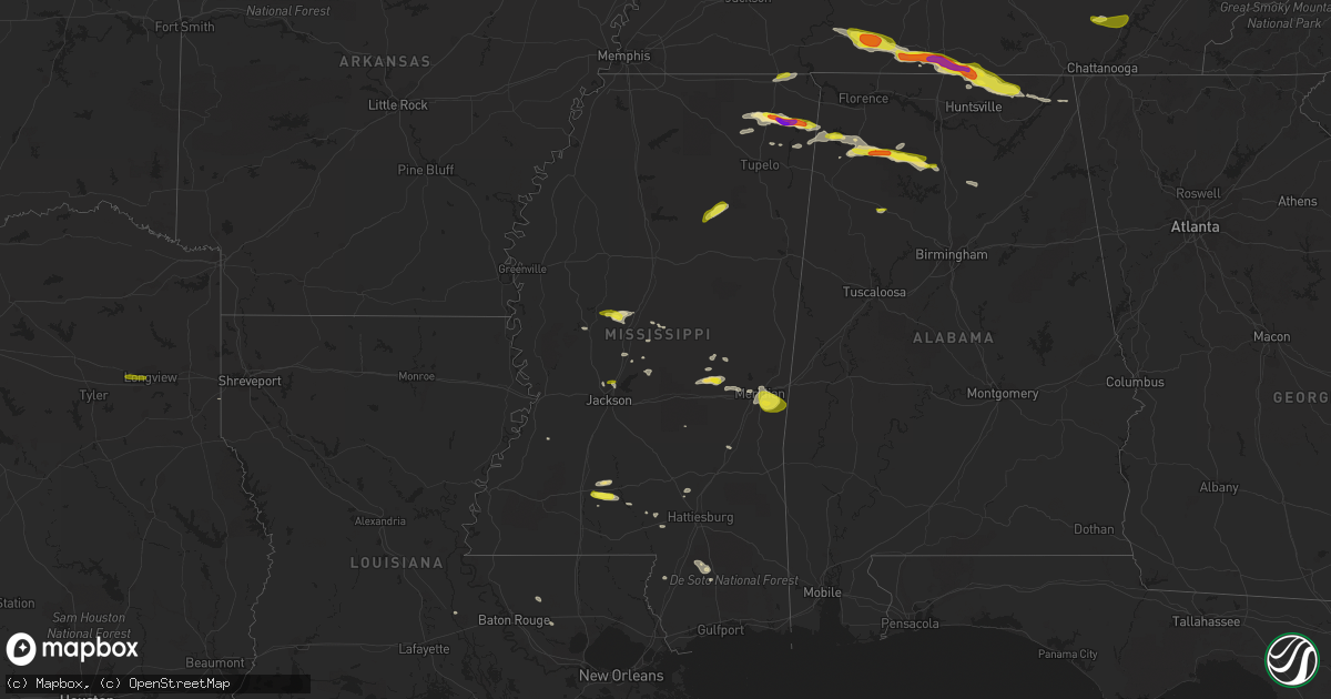
Hail Map in Mississippi on April 22, 2017
Get this storm
April 22 map
$229
one time, instant access
Download today. No call, no setup
Keep the $229
Bought the map and want the full workflow? Apply the entire $229 to a subscription within 7 days. None of it is wasted.
Every map, not just this one
This buys you this map. Subscription and you get every map we run, in the markets you choose from a few cities to whole states to nationwide. Plus real-time alerts the moment a storm fires.
Contact data
Name, contact info, occupancy, even credit band for addresses in the footprint. You go from where it hit to who to call.
Become the source they trust
Unlimited branding weather history reports on demand. You already have the documented answer ready for the property owner, and you are the one who showed up with it.
Property data and RoofTrace estimates
Pull up any address you have got, its value and the exact code rules for that jurisdiction, straight from One Click Code. Then RoofTrace estimates the squares, pitch, and roof value, priced the way you price.
Storm reports in Mississippi
Mississippi
| Date | Description |
|---|---|
| 04/22/20176:58 PM CDT | Tree down across hwy 18. |
| 04/22/20176:53 PM CDT | Trees down in sylvarena. |
| 04/22/20176:35 PM CDT | Tree downed on county road 451. |
| 04/22/20176:30 PM CDT | A few trees down in the northeast portion of clarke county along hwy 514. |
| 04/22/20176:20 PM CDT | Numerous trees down across southeastern lauderdale county. |
| 04/22/20175:50 PM CDT | Trees down along briarwood road near northeast high school. |
| 04/22/20175:45 PM CDT | Dozens of trees and power lines blown down across meridian. |
| 04/22/20175:43 PM CDT | Trees down near the intersection of poplar springs drive and 41st street. |
| 04/22/20175:42 PM CDT | Tree on a house at the intersection of 23rd ave and 34th street. |
| 04/22/20175:05 PM CDT | Report received via mping. |
| 04/22/20175:03 PM CDT | Tree down along north livingston road near the intersection of lewis drive. |
| 04/22/20175:00 PM CDT | Power line down on county road 509. |
| 04/22/20174:50 PM CDT | Tree blocking the south bound lane of county road 505. |
| 04/22/20174:40 PM CDT | Tree down across county road 347. |
| 04/22/20173:45 PM CDT | Tree down on a power line near the intersection of county road 4167 and sallis mcadans road. |
| 04/22/20173:18 PM CDT | Possible tornado in the belmont and golden vicinty. Three houses with roofs torn off. Power lines and trees down. An apartment building and five additional houses had m |
| 04/22/20173:07 PM CDT | Tree down along hwy 17. |
| 04/22/20172:55 PM CDT | Large tree uprooted in the van vleet community along highway 32. |
| 04/22/20172:52 PM CDT | Fire department reporting tornado on the ground on county road 3401 |
| 04/22/20172:49 PM CDT | Public reported 2 inch hail. Time estimated based on radar. |
| 04/22/20172:47 PM CDT | Golf ball size hail reported |
| 04/21/20178:55 PM CDT | Tree down on tatum salt dome road. |
| 04/21/20178:45 PM CDT | Tree down on south mill creek road. |
| 04/21/20177:36 PM CDT | Trees and power lines down across hwy 29 in the johnson community. |
All States Impacted by Hail Map on April 22, 2017
Cities Impacted by Hail Map on April 22, 2017
- Yale, VA
- Jarratt, VA
- Capron, VA
- Drewryville, VA
- Emporia, VA
- Stony Creek, VA
- Hazel Green, AL
- Toney, AL
- Wiggins, MS
- Lumberton, MS
- New Market, AL
- Cullman, AL
- Vinemont, AL
- Hackleburg, AL
- Hodges, AL
- Columbia, MS
- Gurley, AL
- Scottsboro, AL
- Goodspring, TN
- Taft, TN
- Waynesboro, TN
- Estillfork, AL
- Leoma, TN
- Princeton, AL
- Collinwood, TN
- Ardmore, AL
- Pulaski, TN
- Prospect, TN
- Westpoint, TN
- Meridianville, AL
- Flintville, TN
- Fayetteville, TN
- Lawrenceburg, TN
- Hollytree, AL
- Ardmore, TN
- Dellrose, TN
- Decatur, MS
- Conehatta, MS
- Phil Campbell, AL
- Tishomingo, MS
- Marietta, MS
- Dumas, MS
- Dennis, MS
- Belmont, MS
- Ripley, MS
- New Site, MS
- Baldwyn, MS
- Booneville, MS
- Knoxville, TN
- Bracey, VA
- Monticello, MS
- Brookhaven, MS
- Sontag, MS
- Gates, NC
- Suffolk, VA
- Houston, MS
- Vardaman, MS
- Jayess, MS
- Durant, MS
- Murfreesboro, NC
- Como, NC
- Pendleton, NC
- Ridgeland, MS
- Powell, TN
- Freeman, VA
- Lawrenceville, VA
- Union, MS
- Lexington, MS
- Lena, MS
- Sallis, MS
- Garysburg, NC
- Margarettsville, NC
- Corapeake, NC
- Seaboard, NC
- Conway, NC
- Jackson, NC
- Canton, MS
- Meridian, MS
- Loretto, TN
- Fackler, AL
- Clifton, TN
- Heidelberg, MS
- Moneta, VA
- Townley, AL
- Carbon Hill, AL
- Minor Hill, TN
- Ararat, VA
- Claudville, VA
- Mount Airy, NC
- Cana, VA
- Lake, MS
- Little Rock, MS
- Red Oak, VA
- South Hill, VA
- Baskerville, VA
- Clarksville, VA
- La Crosse, VA
- Skipwith, VA
- Chase City, VA
- Boydton, VA
- Brodnax, VA
- Houston, AL
- Addison, AL
- Danville, AL
- Russellville, AL
- Moulton, AL
- Hickory, MS
- Chunky, MS
- Red Bay, AL
- Lottie, LA
- Sale Creek, TN
- Vina, AL
- Gladys, VA
- Altavista, VA
- Marion, MS
- Randolph, VA
- Rocky Mount, VA
- Boones Mill, VA
- Callaway, VA
- Burnsville, MS
- Corinth, MS
- Michie, TN
- Axton, VA
- Callands, VA
- Haleyville, AL
- Golden, MS
- Spruce Pine, AL
- Yazoo City, MS
- Seymour, TN
- Clinton, TN
- Strawberry Plains, TN
- Sevierville, TN
- Kodak, TN
- Denham Springs, LA
- Walker, LA
- Oak Vale, MS
- Fulton, MS
- Hurt, VA
- Dandridge, TN
- Hermanville, MS
- Dunlap, TN
- Ruth, MS
- Bedford, VA
- Huddleston, VA
- Lynch Station, VA
- Oak Ridge, TN
- Pickens, MS
- Flat Rock, AL
- Stanleytown, VA
- Martinsville, VA
- Fieldale, VA
- Collinsville, VA
- Bassett, VA
- Livingston, LA
- Raleigh, MS
- Glade Hill, VA
- Seminary, MS
- Guntown, MS
- Buffalo Junction, VA
- Virgilina, VA
- Hollywood, AL
- Stevenson, AL
- Perkinston, MS
- Blountsville, AL
- Hanceville, AL
- Philadelphia, MS
- Poplarville, MS
- De Berry, TX
- Sunbury, NC
- Camden, MS
- Kosciusko, MS
- New Albany, MS
- Jackson, MS
- South Mills, NC
- Calhoun City, MS
- Eure, NC
- Ahoskie, NC
- Winton, NC
- Patrick Springs, VA
- Madison, MS
- Newport, TN
- New Market, TN
- Chatham, VA
- Brookneal, VA
- Clover, VA
- Nathalie, VA
- Elora, TN
- Dayton, TN
- Soddy Daisy, TN
- Graysville, TN
- Kilgore, TX
- Longview, TX
- Gladewater, TX


