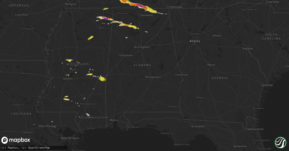
Hail Map in Alabama on April 22, 2017
Get this storm
April 22 map
$229
one time, instant access
Download today. No call, no setup
Keep the $229
Bought the map and want the full workflow? Apply the entire $229 to a subscription within 7 days. None of it is wasted.
Every map, not just this one
This buys you this map. Subscription and you get every map we run, in the markets you choose from a few cities to whole states to nationwide. Plus real-time alerts the moment a storm fires.
Contact data
Name, contact info, occupancy, even credit band for addresses in the footprint. You go from where it hit to who to call.
Become the source they trust
Unlimited branding weather history reports on demand. You already have the documented answer ready for the property owner, and you are the one who showed up with it.
Property data and RoofTrace estimates
Pull up any address you have got, its value and the exact code rules for that jurisdiction, straight from One Click Code. Then RoofTrace estimates the squares, pitch, and roof value, priced the way you price.
Storm reports in Alabama
Alabama
| Date | Description |
|---|---|
| 04/22/20176:56 PM CDT | Trees down on cr-26 in the royal community. |
| 04/22/20176:50 PM CDT | Trees down at us-278 and al-79 in brooksville. |
| 04/22/20176:00 PM CDT | Trees down at webb circle and cr-14 in snead. |
| 04/22/20175:56 PM CDT | Trees down on cr-26 in the royal community. |
| 04/22/20175:55 PM CDT | Multiple trees down on county road 1141 and on county road 1114... Some across the road. |
| 04/22/20175:50 PM CDT | Trees down at us-278 and al-79 in brooksville. |
| 04/22/20175:46 PM CDT | Large tree on house. |
| 04/22/20175:46 PM CDT | Trees down and power outages. County road 17 blocked by trees. |
| 04/22/20175:45 PM CDT | Overturned cars and trucks with barn damage near county road 1055 and county road 1082. Time is radar estimated. |
| 04/22/20175:40 PM CDT | Ef-0 with maximum wind speed of 85 mph... Path length of 2.19 miles... And maximum path width of 200 yards. |
| 04/22/20175:40 PM CDT | Chicken house damaged. |
| 04/22/20175:40 PM CDT | Ef-1 with maximum wind speed of 100 mph... Path length of 4.39 miles... And maximum path width of 200 yards. |
| 04/22/20175:33 PM CDT | Several trees were blown down... Blocking a road. |
| 04/22/20175:33 PM CDT | The metal roofs of several chicken houses sustained damage. |
| 04/22/20175:08 PM CDT | A local report indicates 1.00 inch wind near 2 ESE HAZEL GREEN |
| 04/22/20174:33 PM CDT | Several trees were blown down... Blocking a road. |
| 04/22/20174:33 PM CDT | The metal roofs of several chicken houses sustained damage. |
| 04/22/20174:16 PM CDT | Trees down on cars on highway 43. |
| 04/22/20174:08 PM CDT | Trees down across the road on us 43 just south of spruce pine. |
| 04/22/20173:55 PM CDT | Quarter sized hail reported. |
| 04/22/20173:45 PM CDT | Debris reported falling at intersection 247 and 23. Damage reported at the shiloh baptist church. Debris signature on radar. Relayed by media and ema. |
| 04/22/20173:31 PM CDT | Ef-0 with maximum wind speed of 75 mph... Path length of 5.6 miles... And maximum path width of 720 yards. |
| 04/21/20177:00 PM CDT | Trees down at webb circle and cr-14 in snead. |
All States Impacted by Hail Map on April 22, 2017
Cities Impacted by Hail Map on April 22, 2017
- Yale, VA
- Jarratt, VA
- Capron, VA
- Drewryville, VA
- Emporia, VA
- Stony Creek, VA
- Hazel Green, AL
- Toney, AL
- Wiggins, MS
- Lumberton, MS
- New Market, AL
- Cullman, AL
- Vinemont, AL
- Hackleburg, AL
- Hodges, AL
- Columbia, MS
- Gurley, AL
- Scottsboro, AL
- Goodspring, TN
- Taft, TN
- Waynesboro, TN
- Estillfork, AL
- Leoma, TN
- Princeton, AL
- Collinwood, TN
- Ardmore, AL
- Pulaski, TN
- Prospect, TN
- Westpoint, TN
- Meridianville, AL
- Flintville, TN
- Fayetteville, TN
- Lawrenceburg, TN
- Hollytree, AL
- Ardmore, TN
- Dellrose, TN
- Decatur, MS
- Conehatta, MS
- Phil Campbell, AL
- Tishomingo, MS
- Marietta, MS
- Dumas, MS
- Dennis, MS
- Belmont, MS
- Ripley, MS
- New Site, MS
- Baldwyn, MS
- Booneville, MS
- Knoxville, TN
- Bracey, VA
- Monticello, MS
- Brookhaven, MS
- Sontag, MS
- Gates, NC
- Suffolk, VA
- Houston, MS
- Vardaman, MS
- Jayess, MS
- Durant, MS
- Murfreesboro, NC
- Como, NC
- Pendleton, NC
- Ridgeland, MS
- Powell, TN
- Freeman, VA
- Lawrenceville, VA
- Union, MS
- Lexington, MS
- Lena, MS
- Sallis, MS
- Garysburg, NC
- Margarettsville, NC
- Corapeake, NC
- Seaboard, NC
- Conway, NC
- Jackson, NC
- Canton, MS
- Meridian, MS
- Loretto, TN
- Fackler, AL
- Clifton, TN
- Heidelberg, MS
- Moneta, VA
- Townley, AL
- Carbon Hill, AL
- Minor Hill, TN
- Ararat, VA
- Claudville, VA
- Mount Airy, NC
- Cana, VA
- Lake, MS
- Little Rock, MS
- Red Oak, VA
- South Hill, VA
- Baskerville, VA
- Clarksville, VA
- La Crosse, VA
- Skipwith, VA
- Chase City, VA
- Boydton, VA
- Brodnax, VA
- Houston, AL
- Addison, AL
- Danville, AL
- Russellville, AL
- Moulton, AL
- Hickory, MS
- Chunky, MS
- Red Bay, AL
- Lottie, LA
- Sale Creek, TN
- Vina, AL
- Gladys, VA
- Altavista, VA
- Marion, MS
- Randolph, VA
- Rocky Mount, VA
- Boones Mill, VA
- Callaway, VA
- Burnsville, MS
- Corinth, MS
- Michie, TN
- Axton, VA
- Callands, VA
- Haleyville, AL
- Golden, MS
- Spruce Pine, AL
- Yazoo City, MS
- Seymour, TN
- Clinton, TN
- Strawberry Plains, TN
- Sevierville, TN
- Kodak, TN
- Denham Springs, LA
- Walker, LA
- Oak Vale, MS
- Fulton, MS
- Hurt, VA
- Dandridge, TN
- Hermanville, MS
- Dunlap, TN
- Ruth, MS
- Bedford, VA
- Huddleston, VA
- Lynch Station, VA
- Oak Ridge, TN
- Pickens, MS
- Flat Rock, AL
- Stanleytown, VA
- Martinsville, VA
- Fieldale, VA
- Collinsville, VA
- Bassett, VA
- Livingston, LA
- Raleigh, MS
- Glade Hill, VA
- Seminary, MS
- Guntown, MS
- Buffalo Junction, VA
- Virgilina, VA
- Hollywood, AL
- Stevenson, AL
- Perkinston, MS
- Blountsville, AL
- Hanceville, AL
- Philadelphia, MS
- Poplarville, MS
- De Berry, TX
- Sunbury, NC
- Camden, MS
- Kosciusko, MS
- New Albany, MS
- Jackson, MS
- South Mills, NC
- Calhoun City, MS
- Eure, NC
- Ahoskie, NC
- Winton, NC
- Patrick Springs, VA
- Madison, MS
- Newport, TN
- New Market, TN
- Chatham, VA
- Brookneal, VA
- Clover, VA
- Nathalie, VA
- Elora, TN
- Dayton, TN
- Soddy Daisy, TN
- Graysville, TN
- Kilgore, TX
- Longview, TX
- Gladewater, TX


