Hail Map in Weatherford, TX on April 21, 2018
The weather event in Weatherford, TX on April 21, 2018 includes Hail map. 1 state and 64 cities were impacted and suffered possible damage. The total estimated number of properties impacted is 15,756.
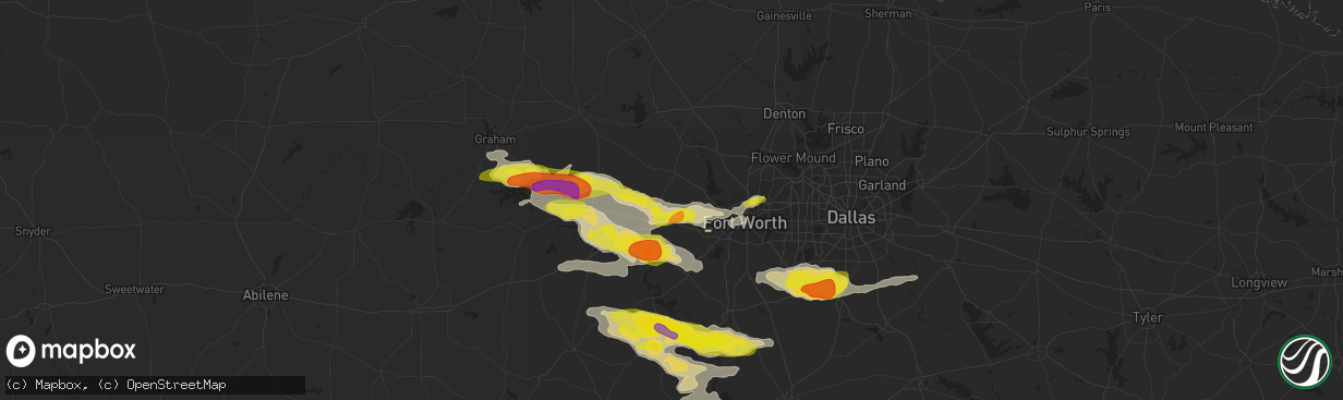
Hail
15,756
Estimated number of impacted properties by a 1.00" hail or larger1,986
Estimated number of impacted properties by a 1.75" hail or larger0
Estimated number of impacted properties by a 2.50" hail or largerStorm reports in Weatherford, TX
Weatherford, TX
| Date | Description |
|---|---|
| 04/21/20185:29 PM CDT | On tip top road |
| 04/21/20185:26 PM CDT | A local report indicates 1.25 inch wind near 9 SSW WEATHERFORD |
| 04/21/20185:26 PM CDT | A local report indicates 1.75 inch wind near 10 S WEATHERFORD |
| 04/21/20185:08 PM CDT | Off farmer road |
| 04/21/20184:34 PM CDT | A local report indicates 1.00 inch wind near PEASTER |
All States Impacted by Hail Map on April 21, 2018
All Cities Impacted by Hail Map on April 21, 2018
- Childress, TX
- Granbury, TX
- Glen Rose, TX
- Rainbow, TX
- Tolar, TX
- Cleburne, TX
- Nemo, TX
- Weatherford, TX
- Fort Worth, TX
- Graford, TX
- Palo Pinto, TX
- Mineral Wells, TX
- Lipan, TX
- Millsap, TX
- Santo, TX
- Cresson, TX
- Morgan, TX
- Meridian, TX
- Haltom City, TX
- Iola, TX
- Bryan, TX
- Rio Vista, TX
- Covington, TX
- Blum, TX
- Walnut Springs, TX
- Kopperl, TX
- Stephenville, TX
- Grandview, TX
- Whitney, TX
- Bluff Dale, TX
- Azle, TX
- Aledo, TX
- Naval Air Station Jrb, TX
- Perrin, TX
- Bridgeport, TX
- Paradise, TX
- Bryson, TX
- Poolville, TX
- North Richland Hills, TX
- Graham, TX
- Whitt, TX
- Godley, TX
- Turkey, TX
- Scurry, TX
- Sanger, TX
- Krum, TX
- Cedar Hill, TX
- Ferris, TX
- Burleson, TX
- Red Oak, TX
- Grand Prairie, TX
- Palmer, TX
- Waxahachie, TX
- Mansfield, TX
- Midlothian, TX
- Alvarado, TX
- Venus, TX
- Lillian, TX
- Decatur, TX
- Rhome, TX
- Boyd, TX
- Iredell, TX
- College Station, TX
- Breckenridge, TX


