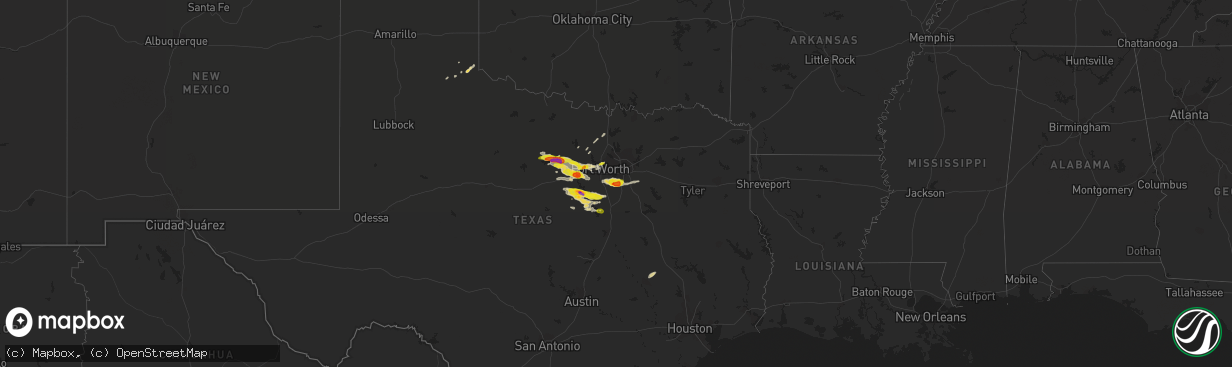
Hail Map on April 21, 2018
The weather event on April 21, 2018 includes Hail map. 1 state and 64 cities were impacted and suffered possible damage. The total estimated number of properties impacted is 52,525.
Want more than just the map?
Turn this storm into a full workflow.
- Owner + property data so you know who to knock
- OnDemand branded weather history reports to win the "did we even have hail?" argument
- RoofTrace estimate so reps stop guessing numbers at the door
Bought this map? Upgrade within 7 days and we'll credit the $230. (10-15 min setup call)
Hail
52,525
Estimated number of impacted properties by a 1.00" hail or larger12,205
Estimated number of impacted properties by a 1.75" hail or larger0
Estimated number of impacted properties by a 2.50" hail or largerStates Impacted by Hail Map on April 21, 2018
Storm reports
Texas
| Date | Description |
|---|---|
| 04/21/20186:54 PM CDT | A local report indicates 1.00 inch wind near RIO VISTA |
| 04/21/20186:11 PM CDT | A local report indicates 1.00 inch wind near NORTH RICHLAND HILLS |
| 04/21/20186:08 PM CDT | A local report indicates 2.00 inch wind near 6 N GLEN ROSE |
| 04/21/20185:29 PM CDT | On tip top road |
| 04/21/20185:26 PM CDT | A local report indicates 1.25 inch wind near 9 SSW WEATHERFORD |
| 04/21/20185:26 PM CDT | A local report indicates 1.75 inch wind near 10 S WEATHERFORD |
| 04/21/20185:08 PM CDT | Off farmer road |
| 04/21/20184:50 PM CDT | A local report indicates 1.00 inch wind near MINERAL WELLS |
| 04/21/20184:34 PM CDT | A local report indicates 1.00 inch wind near PEASTER |
| 04/21/20184:09 PM CDT | A local report indicates 1.25 inch wind near 2 SE GRAFORD |
| 04/21/20184:06 PM CDT | Near hwy 254 and fm52 |
| 04/21/20184:00 PM CDT | A local report indicates 1.00 inch wind near 2 W GRAFORD |
| 04/21/20182:04 AM CDT | At 704 PM CDT, a severe thunderstorm was located near Midlothian, moving east at 30 mph. HAZARD...60 mph wind gusts and quarter size hail. SOURCE...Radar indicated. IMPACT...Hail damage to vehicles is expected. Expect wind damage to roofs, siding, and trees. Locations impacted include... Grand Prairie, Mansfield, Desoto, Cedar Hill, Lancaster, Waxahachie, Ennis, Midlothian, Glenn Heights, Red Oak, Wilmer, Ovilla, Venus, Ferris, Palmer, Combine, Oak Leaf and Pecan Hill.This includes the following interstates... Interstate 35E between mile markers 401 and 413. Interstate 45 between mile markers 256 and 269. |
| 04/21/20181:43 AM CDT | At 643 PM CDT, severe thunderstorms were located along a line extending from near Cleburne to near Iredell, moving east at 35 mph. HAZARD...60 mph wind gusts and half dollar size hail. SOURCE...Radar indicated. IMPACT...Hail damage to vehicles is expected. Expect wind damage to roofs, siding, and trees. Locations impacted include... Cleburne, Hillsboro, Whitney, Italy, Itasca, Grandview, Meridian, Blum, Iredell, Covington, Carl's Corner, Cleburne State Park, Lake Whitney State Park, Rio Vista, Walnut Springs, Milford and Morgan.This includes the following interstates... Interstate 35 between mile markers 364 and 369. Interstate 35W between mile markers 1 and 17. Interstate 35E between mile markers 371 and 389. |
| 04/21/20181:02 AM CDT | At 602 PM CDT, a severe thunderstorm was located over Haltom City, moving east at 20 mph. HAZARD...60 mph wind gusts and quarter size hail. SOURCE...Trained weather spotters. IMPACT...Hail damage to vehicles is expected. Expect wind damage to roofs, siding, and trees. Locations impacted include... Dallas, Fort Worth, Arlington, Irving, Grand Prairie, Euless, Bedford, Grapevine, Haltom City, Keller, Hurst, Farmers Branch, Watauga, Colleyville, Saginaw, Richland Hills, Cockrell Hill, North Richland Hills and Blue Mound.This includes the following interstates... Interstate 35W between mile markers 53 and 61. Interstate 35E between mile markers 433 and 439. Interstate 30 between mile markers 20 and 41. |
| 04/21/201812:49 AM CDT | At 548 PM CDT, a severe thunderstorm was located 9 miles northwest of Dinosaur Valley State Park, or 10 miles southwest of Granbury, moving east at 25 mph. HAZARD...60 mph wind gusts and quarter size hail. SOURCE...Radar indicated. IMPACT...Hail damage to vehicles is expected. Expect wind damage to roofs, siding, and trees. Locations impacted include... Cleburne, Pecan Plantation, Glen Rose, Cleburne State Park, Dinosaur Valley State Park, Rio Vista and Tolar. |
| 04/21/201812:05 AM CDT | At 503 PM CDT, two severe thunderstorms located near Willow Park and 8 miles south of Cool, moving east at 35 mph. HAZARD...60 mph wind gusts and quarter size hail. SOURCE...Radar indicated. IMPACT...Hail damage to vehicles is expected. Expect wind damage to roofs, siding, and trees. Locations impacted include... Fort Worth, Bedford, Haltom City, Keller, Hurst, Weatherford, Watauga, Colleyville, Benbrook, Saginaw, Mineral Wells, White Settlement, Crowley, Forest Hill, Azle, Richland Hills, River Oaks, Sansom Park, Lake Worth and Eagle Mountain.This includes the following interstates... Interstate 35W between mile markers 43 and 61. Interstate 20 between mile markers 390 and 438. Interstate 30 between mile markers 1 and 21. |
| 04/20/201811:15 PM CDT | At 414 PM CDT, a severe thunderstorm was located near Mineral Wells, moving east at 35 mph. HAZARD...60 mph wind gusts and quarter size hail. SOURCE...Radar indicated. IMPACT...Hail damage to vehicles is expected. Expect wind damage to roofs, siding, and trees. Locations impacted include... Weatherford, Mineral Wells, Azle, Briar, Willow Park, Reno, Aledo, Springtown, Hudson Oaks, Cool, Poolville, Mineral Wells State Park, Annetta North and Sanctuary.This includes the following interstates... Interstate 20 between mile markers 408 and 422. Interstate 30 near mile marker 1. |
| 04/20/201810:26 PM CDT | At 326 PM CDT, a severe thunderstorm was located near Possum Kingdom State Park, or 9 miles south of Graham, moving east at 25 mph. HAZARD...60 mph wind gusts and quarter size hail. SOURCE...Radar indicated. IMPACT...Hail damage to vehicles is expected. Expect wind damage to roofs, siding, and trees. Locations impacted include... Mineral Wells, Graford and Possum Kingdom State Park. |
| 04/20/20187:30 PM CDT | A local report indicates 1.00 inch wind near 4 N WAXAHACHIE |
| 04/20/20187:30 PM CDT | A local report indicates 1.00 inch wind near WAXAHACHIE |
| 04/20/20187:26 PM CDT | A local report indicates 1.25 inch wind near MIDLOTHIAN |
| 04/20/20187:24 PM CDT | A local report indicates 1.00 inch wind near MIDLOTHIAN |
| 04/20/20187:18 PM CDT | A local report indicates 1.00 inch wind near OVILLA |
| 04/20/20187:12 PM CDT | A local report indicates 1.50 inch wind near MIDLOTHIAN |
Cities Impacted by Hail Map on April 21, 2018
- Childress, TX
- Granbury, TX
- Glen Rose, TX
- Rainbow, TX
- Tolar, TX
- Cleburne, TX
- Nemo, TX
- Weatherford, TX
- Fort Worth, TX
- Graford, TX
- Palo Pinto, TX
- Mineral Wells, TX
- Lipan, TX
- Millsap, TX
- Santo, TX
- Cresson, TX
- Morgan, TX
- Meridian, TX
- Haltom City, TX
- Iola, TX
- Bryan, TX
- Rio Vista, TX
- Covington, TX
- Blum, TX
- Walnut Springs, TX
- Kopperl, TX
- Stephenville, TX
- Grandview, TX
- Whitney, TX
- Bluff Dale, TX
- Azle, TX
- Aledo, TX
- Naval Air Station Jrb, TX
- Perrin, TX
- Bridgeport, TX
- Paradise, TX
- Bryson, TX
- Poolville, TX
- North Richland Hills, TX
- Graham, TX
- Whitt, TX
- Godley, TX
- Turkey, TX
- Scurry, TX
- Sanger, TX
- Krum, TX
- Cedar Hill, TX
- Ferris, TX
- Burleson, TX
- Red Oak, TX
- Grand Prairie, TX
- Palmer, TX
- Waxahachie, TX
- Mansfield, TX
- Midlothian, TX
- Alvarado, TX
- Venus, TX
- Lillian, TX
- Decatur, TX
- Rhome, TX
- Boyd, TX
- Iredell, TX
- College Station, TX
- Breckenridge, TX