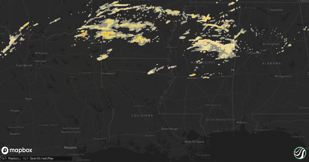
Hail Map in Mississippi on April 20, 2011
Get this storm
April 20 map
$229
one time, instant access
Download today. No call, no setup
Keep the $229
Bought the map and want the full workflow? Apply the entire $229 to a subscription within 7 days. None of it is wasted.
Every map, not just this one
This buys you this map. Subscription and you get every map we run, in the markets you choose from a few cities to whole states to nationwide. Plus real-time alerts the moment a storm fires.
Contact data
Name, contact info, occupancy, even credit band for addresses in the footprint. You go from where it hit to who to call.
Become the source they trust
Unlimited branding weather history reports on demand. You already have the documented answer ready for the property owner, and you are the one who showed up with it.
Property data and RoofTrace estimates
Pull up any address you have got, its value and the exact code rules for that jurisdiction, straight from One Click Code. Then RoofTrace estimates the squares, pitch, and roof value, priced the way you price.
Storm reports in Mississippi
Mississippi
| Date | Description |
|---|---|
| 04/20/20116:59 PM CDT | A local report indicates 1.00 inch wind near 4 S HOLCOMB |
| 04/20/20116:55 PM CDT | A local report indicates 1.00 inch wind near VAIDEN |
| 04/20/20116:51 PM CDT | Golf ball hail in downtown oxford around jackson street. |
| 04/20/20116:50 PM CDT | Quarter hail on campus of university of mississippi |
| 04/20/20116:48 PM CDT | Golf ball hail 1 mile west of city limits of oxford |
| 04/20/20116:35 PM CDT | Half dollar to tennis ball hail near duck hill. |
| 04/20/20116:25 PM CDT | A local report indicates 1.00 inch wind near ELLIOTT |
| 04/20/20116:15 PM CDT | Trees down north of batesville. |
| 04/20/20116:15 PM CDT | Multiple trees downed between carrollton and winona. |
| 04/20/20115:53 PM CDT | A local report indicates 1.25 inch wind near CARROLLTON |
| 04/20/20115:40 PM CDT | Winds estimated at 60 mph in blue springs. |
| 04/20/20115:39 PM CDT | A local report indicates 1.00 inch wind near 6 W CARROLLTON |
| 04/20/20115:35 PM CDT | Reported in the highland plantation area |
| 04/20/20115:20 PM CDT | Quarter to golf ball size hail |
| 04/20/20114:58 PM CDT | Sizes ranging from half inch to golf ball |
| 04/20/20114:55 PM CDT | Quarter and nickel sized hail covering ground at home located at 3226 kendrick rd corinth. |
| 04/20/20114:55 PM CDT | Quarter to half dollar sized hail covering steps of mobile home on hwy 348 |
| 04/20/20114:40 PM CDT | A local report indicates 1.75 inch wind near 6 W STARKVILLE |
| 04/20/20114:30 PM CDT | Sizes ranging from golfball to baseball |
| 04/20/20113:48 PM CDT | A local report indicates 1.75 inch wind near 2 NW SHERWOOD |
| 04/20/20113:40 PM CDT | Sizes ranging from dime to quarter |
| 04/20/20113:15 PM CDT | A local report indicates 1.75 inch wind near WALTHALL |
| 04/20/20113:00 PM CDT | Multiple reports of golf ball size hail over western webster county |
| 04/20/20112:20 PM CDT | Reported in the red hill area |
| 04/20/20112:20 PM CDT | Quarter size hail covering the ground |
| 04/20/20112:15 PM CDT | A local report indicates 1.75 inch wind near DUCK HILL |
| 04/20/20112:05 PM CDT | Quarter size hail reported at the intersection of hwy 45 and main street in verona. |
| 04/20/20112:05 PM CDT | A local report indicates 1.00 inch wind near ELLIOTT |
| 04/20/20112:00 PM CDT | A local report indicates 1.50 inch wind near VERONA |
| 04/20/20111:55 PM CDT | A local report indicates 1.75 inch wind near JEFFERSON |
| 04/20/20111:45 PM CDT | A local report indicates 1.75 inch wind near 3 NNW JEFFERSON |
| 04/20/20111:40 PM CDT | A local report indicates 1.75 inch wind near 4 NW JEFFERSON |
| 04/20/20111:00 PM CDT | A local report indicates 1.00 inch wind near MONEY |
| 04/20/201112:29 PM CDT | Some trees were blown down on open pasture in town. |
| 04/20/201112:22 PM CDT | Ping pong ball size hail in the town of wallfield. |
| 04/20/201111:58 AM CDT | A local report indicates 1.00 inch wind near RANDOLPH |
| 04/20/201111:29 AM CDT | A local report indicates 1.25 inch wind near 3 S TULA |
| 04/20/201111:07 AM CDT | A local report indicates 1.00 inch wind near 2 N PARIS |
| 04/20/201110:54 AM CDT | Hail slightly larger than quarter size was reported by a storm spotter near the town of taylor. |
| 04/20/201110:42 AM CDT | Golf ball size hail reported by a storm spotter near college hill...relayed by emergency manager. |
| 04/20/20117:04 AM CDT | A local report indicates 1.00 inch wind near 2 SW STARKVILLE |
| 04/20/201112:04 AM CDT | A local report indicates 1.00 inch wind near 4 S FOREST |
| 04/19/201110:10 PM CDT | Reported at highland colony parkway...old canton road and highway 51 |
| 04/19/201110:04 PM CDT | Ping pong ball size hail just west of interstate 55 in ridgeland |
| 04/19/20119:43 PM CDT | Couple of trees down in macon |
| 04/19/20119:34 PM CDT | 3 to 4 trees down in town of brooksville. |
| 04/19/20119:30 PM CDT | A local report indicates 1.25 inch wind near 3 NW MASHULAVILLE |
| 04/19/20119:15 PM CDT | Three trees knocked down |
| 04/19/20119:13 PM CDT | Quarter sized hail in amory |
| 04/19/20119:10 PM CDT | Tree down on school road |
| 04/19/20119:10 PM CDT | A local report indicates 1.00 inch wind near AMORY |
| 04/19/20119:10 PM CDT | Tree down across northwood forrest road |
| 04/19/20119:10 PM CDT | Power line down in front of caledonia high school on wolfe road |
| 04/19/20119:06 PM CDT | Tree down on a house on old crawford road |
| 04/19/20119:00 PM CDT | Several trees down over northern monroe county. |
| 04/19/20119:00 PM CDT | Trees down county wide. |
| 04/19/20118:57 PM CDT | Trees down...some on power lines |
| 04/19/20118:52 PM CDT | Tree down across northwood forrest road |
| 04/19/20118:52 PM CDT | Trees down on hwy 12 west of kosciusko. |
| 04/19/20118:50 PM CDT | Trees down on southeast side of starkville |
| 04/19/20118:50 PM CDT | Tree down on house on cedar bluff loop |
| 04/19/20118:48 PM CDT | A local report indicates 1.75 inch wind near COLUMBUS |
| 04/19/20118:45 PM CDT | Trees down in the northwest and west-central part of the county. Location approximate. |
| 04/19/20118:42 PM CDT | Reported at the county eoc |
| 04/19/20118:35 PM CDT | Reported along alabama st...also penny size hail falling on nashville ferry rd. |
| 04/19/20118:30 PM CDT | Trees down across the southern end of lee county. |
| 04/19/20118:30 PM CDT | Several trees down in town |
| 04/19/20118:25 PM CDT | Trees down across the county. One fell on a house |
| 04/19/20118:15 PM CDT | Estimated winds of 60 mph blowing through town of shannon |
| 04/19/20118:10 PM CDT | A couple trees were downed along cr 3122 |
| 04/19/20118:10 PM CDT | Trees and power lines down...homes damaged. A tree was uprooted on highway 8 which pulled up a gas line. |
| 04/19/20118:09 PM CDT | Storm survey found a 3.5 mile tornado path with a max width of 150 yards 1 s of tomnolen to 2.7 nne of tomnolen. Hardwood and pine tree damage...along with roof damage |
| 04/19/20118:08 PM CDT | Several trees down across roads in the stewart community. |
| 04/19/20118:00 PM CDT | *** 1 inj *** trees down county wide. One tree fell on a home in houston resulting in injuries to a child. The child was treated for cuts and briuses and released. |
| 04/19/20117:58 PM CDT | Several trees down in city |
| 04/19/20117:55 PM CDT | Tree down on a car and a home. Also...tree down blocking highway 12 north of sturgis |
| 04/19/20117:50 PM CDT | A tree was downed along 20th st n. |
| 04/19/20117:40 PM CDT | Several trees down across roads in the duck hill area. |
| 04/19/20117:40 PM CDT | Several trees and power lines downed across the city of grenada...and in grenada county east of the city. |
| 04/19/20117:38 PM CDT | Several trees down north of seven pines community. |
| 04/19/20117:35 PM CDT | A local report indicates 1.75 inch wind near KILMICHAEL |
| 04/19/20117:35 PM CDT | Reported along tarlton rd |
| 04/19/20117:35 PM CDT | Power poles snapped...trees downed...and a porch blown off a house |
| 04/19/20117:22 PM CDT | Tree knocked down on to a mobile home |
| 04/19/20117:12 PM CDT | Trees down in the area...one fell on a house trailer. Possible tornado based on sightings |
| 04/19/20117:10 PM CDT | Tree down on top of a mobile home |
| 04/19/20117:05 PM CDT | Reported along gillon rd |
| 04/19/20117:05 PM CDT | Numerous trees down some across roads. Two trees fell on a house...one caused major damage and one minor damage. Possible tornado from reports of sightings |
| 04/19/20117:03 PM CDT | A tree fell on a gas meter behind the sumner post office creating a gas leak. |
| 04/19/20117:02 PM CDT | A local report indicates 1.00 inch wind near 1 S HOLCOMB |
| 04/19/20117:00 PM CDT | Golf ball hail on hwy 30 |
| 04/19/20117:00 PM CDT | A local report indicates 2.50 inch wind near SWEATMAN |
All States Impacted by Hail Map on April 20, 2011
Cities Impacted by Hail Map on April 20, 2011
- Oxford, MS
- Abbeville, MS
- Porterville, MS
- Iraan, TX
- Banks, AR
- Warren, AR
- Summertown, TN
- Lawrenceburg, TN
- Hohenwald, TN
- Bogata, TX
- Savannah, TN
- Junction, TX
- Guin, AL
- Beaverton, AL
- Sulligent, AL
- Piedmont, AL
- Bearden, AR
- Sparkman, AR
- Camden, AR
- Clarksdale, MS
- Greenwood, AR
- Huntington, AR
- Lane, OK
- Caddo, OK
- Atoka, OK
- Caney, OK
- Stringtown, OK
- Conehatta, MS
- Eldorado, TX
- Jacksboro, TX
- New Albany, MS
- Guntown, MS
- Blue Springs, MS
- Jessieville, AR
- Marks, MS
- Tunica, MS
- Coahoma, MS
- Sledge, MS
- Marianna, AR
- Dundee, MS
- French Camp, MS
- Vaiden, MS
- Winona, MS
- Eupora, MS
- Kilmichael, MS
- Stewart, MS
- Clyde, TX
- Muenster, TX
- Norman, AR
- Chunky, MS
- Little Rock, MS
- Collinsville, MS
- Counce, TN
- Chico, TX
- Cedarbluff, MS
- Ballinger, TX
- Waynesboro, TN
- Christoval, TX
- Cascilla, MS
- Holcomb, MS
- Harvey, AR
- Ola, AR
- Perryville, AR
- Bluffton, AR
- Rover, AR
- Briggsville, AR
- Plainview, AR
- Danville, AR
- Gravelly, AR
- Lexa, AR
- Eden, TX
- Vancourt, TX
- Menard, TX
- Hazen, AR
- Nocona, TX
- Broken Bow, OK
- Quemado, TX
- Brackettville, TX
- Wright City, OK
- De Queen, AR
- Gillham, AR
- Lockesburg, AR
- Belzoni, MS
- Silver City, MS
- Keystone Heights, FL
- Starke, FL
- Aubrey, AR
- Marvell, AR
- Holly Grove, AR
- Brinkley, AR
- Idabel, OK
- Old Town, FL
- Branford, FL
- Eagle Pass, TX
- Waldron, AR
- Boles, AR
- Parks, AR
- Okolona, MS
- Bowie, TX
- Roosevelt, TX
- Sonora, TX
- Breckenridge, TX
- Graham, TX
- South Bend, TX
- North Little Rock, AR
- Trenton, FL
- Bell, FL
- Columbus, MS
- Morton, MS
- Coleman, TX
- Novice, TX
- Talpa, TX
- McCaskill, AR
- Saratoga, AR
- Blevins, AR
- Hope, AR
- Columbus, AR
- Mineral Springs, AR
- Ozan, AR
- Fulton, AR
- Prescott, AR
- Washington, AR
- Ashdown, AR
- Nashville, AR
- Emmet, AR
- Clarendon, AR
- Mena, AR
- Hampton, AR
- Carlisle, AR
- Lonoke, AR
- Mathiston, MS
- Ozona, TX
- Chiefland, FL
- McCarley, MS
- Walthall, MS
- Starkville, MS
- North Carrollton, MS
- Pheba, MS
- Mississippi State, MS
- Steens, MS
- Carrollton, MS
- Maben, MS
- Duck Hill, MS
- Brooksville, MS
- Crawford, MS
- Artesia, MS
- Sturgis, MS
- Macon, MS
- Louisville, MS
- De Valls Bluff, AR
- Rienzi, MS
- Glen, MS
- Burnsville, MS
- Booneville, MS
- Talladega, AL
- Munford, AL
- Baird, TX
- Cross Plains, TX
- Moran, TX
- Burkett, TX
- Cisco, TX
- Wilson, OK
- Monticello, AR
- Mill Creek, OK
- Madill, OK
- Mannsville, OK
- Ardmore, OK
- West Point, MS
- Gouldbusk, TX
- Lohn, TX
- Doole, TX
- Casa, AR
- Morrilton, AR
- Transylvania, LA
- Mer Rouge, LA
- Malvern, AR
- Newberry, FL
- Montague, TX
- Rayville, LA
- Oak Ridge, LA
- Monroe, LA
- Mayo, FL
- Haworth, OK
- Clarksville, TX
- Bagwell, TX
- Garvin, OK
- Sheridan, AR
- Grapevine, AR
- Carthage, AR
- Leola, AR
- White Hall, AR
- Pine Bluff, AR
- Weir, MS
- Ackerman, MS
- Bryson, TX
- Cleveland, MS
- Ruleville, MS
- Drew, MS
- Atkins, AR
- Lawtey, FL
- London, TX
- England, AR
- Scott, AR
- Walnut, MS
- Ashland, MS
- Michigan City, MS
- Ethel, MS
- West, MS
- Taylor, MS
- Interlachen, FL
- Hawthorne, FL
- Valera, TX
- Miles, TX
- Winters, TX
- Rowena, TX
- Woodson, TX
- New Boston, TX
- Itta Bena, MS
- Sidon, MS
- Gurdon, AR
- Orange Park, FL
- Jacksonville, FL
- Thornton, AR
- Fordyce, AR
- Melrose, FL
- Florahome, FL
- Royal, AR
- Paint Rock, TX
- Pottsville, AR
- Dardanelle, AR
- De Witt, AR
- Grenada, MS
- Greenwood, MS
- Houston, MS
- Jackson, MS
- Ridgeland, MS
- Madison, MS
- Tougaloo, MS
- Noxapater, MS
- Pontotoc, MS
- Randolph, MS
- Saint Jo, TX
- Sylacauga, AL
- Doddridge, AR
- Sallis, MS
- Winfield, AL
- Roland, AR
- Paron, AR
- Little Rock, AR
- Smithville, OK
- Pierson, FL
- Astor, FL
- Altoona, FL
- Goodman, MS
- Prairie, MS
- Crescent City, FL
- Welaka, FL
- Fort McCoy, FL
- Albany, TX
- Perrin, TX
- Anniston, AL
- Tutwiler, MS
- Charleston, MS
- Grand Junction, TN
- Saulsbury, TN
- Batesville, MS
- Hackett, AR
- Morriston, FL
- Bronson, FL
- McCool, MS
- Powder Springs, GA
- Marietta, GA
- Mereta, TX
- Eola, TX
- Micanopy, FL
- Anthony, FL
- Ocala, FL
- Citra, FL
- Detroit, TX
- Melvin, TX
- Preston, MS
- Elrod, AL
- Gordo, AL
- Loving, TX
- Marietta, OK
- Belden, MS
- Friendship, AR
- Donaldson, AR
- Amity, AR
- Arkadelphia, AR
- Brandon, MS
- Clinton, MS
- Big Lake, TX
- Cruger, MS
- Kirby, AR
- Glenwood, AR
- Caddo Gap, AR
- Langley, AR
- Horatio, AR
- Alleene, AR
- Okolona, AR
- Bluff City, AR
- Delight, AR
- Chidester, AR
- Shannon, MS
- Tupelo, MS
- Banner, MS
- Paris, MS
- Water Valley, MS
- Houlka, MS
- Bolivar, TN
- Middleton, TN
- Baldwyn, MS
- Dumas, MS
- Elaine, AR
- Merigold, MS
- Minter City, MS
- Boyle, MS
- Doddsville, MS
- Grady, AR
- Jasper, AL
- Millington, TN
- Schlater, MS
- San Angelo, TX
- Nashoba, OK
- Clayton, OK
- Mertzon, TX
- Eagletown, OK
- Ohatchee, AL
- Ragland, AL
- Aberdeen, MS
- Camden, MS
- Corinth, MS
- Bismarck, AR
- Williston, FL
- Story, AR
- Dumas, AR
- Green Cove Springs, FL
- Hot Springs National Park, AR
- Woodland, MS
- Vardaman, MS
- Mantee, MS
- Calhoun City, MS
- Lone Grove, OK
- Springer, OK
- Caledonia, MS
- Gattman, MS
- Hamilton, MS
- Umpire, AR
- Dierks, AR
- Mount Ida, AR
- Sims, AR
- Coldwater, MS
- Pickens, MS
- Vaughan, MS
- Saltillo, MS
- McCalla, AL
- Bellevue, TX
- Ringling, OK
- Epps, LA
- Cove, AR
- Hatfield, AR
- Watson, OK
- Vandervoort, AR
- Ethelsville, AL
- Carrollton, AL
- Thaxton, MS
- Etta, MS
- Scooba, MS
- De Kalb, MS
- Shuqualak, MS
- Kennedy, AL
- Fayette, AL
- Rolling Fork, MS
- Archer, FL
- Gainesville, FL
- Bruce, MS
- Aliceville, AL
- Abilene, TX
- Coila, MS
- Avery, TX
- Middleburg, FL
- Bridgeport, TX
- Tuscola, TX
- Buffalo Gap, TX
- Bradley, AR
- Ida, LA
- Atlanta, TX
- Bivins, TX
- Fouke, AR
- Rodessa, LA
- Northport, AL
- Coker, AL
- Star City, AR
- Yorktown, AR
- Texarkana, AR
- Lexington, MS
- Sarah, MS
- Lewisville, AR
- Garland City, AR
- Memphis, TN
- Nettleton, MS
- Alpine, AL
- Childersburg, AL
- Como, MS
- Sardis, MS
- Crenshaw, MS
- Lyon, MS
- Pioneer, LA
- Bauxite, AR
- Murfreesboro, AR
- Heavener, OK
- Gore Springs, MS
- Philadelphia, MS
- Pomona Park, FL
- Senatobia, MS
- Fort Smith, AR
- Rison, AR
- Sherwood, AR
- Jacksonville, AR
- Poplar Grove, AR
- Lake Providence, LA
- Mantachie, MS
- Canton, MS
- Paisley, FL
- Linden, TX
- Finger, TN
- Bethel Springs, TN
- Henderson, TN
- Pelahatchie, MS
- University, MS
- Waterford, MS
- Coffeeville, MS
- Arlington, TN
- Decatur, MS
- Casscoe, AR
- West Helena, AR
- Helena, AR
- Henrietta, TX
- Wilsonville, AL
- Columbiana, AL
- Buhl, AL
- Tishomingo, OK
- New Edinburg, AR
- Harrell, AR
- Wilmar, AR
- Ogden, AR
- Bonnerdale, AR
- Cross City, FL
- Hot Springs Village, AR
- Lonsdale, AR
- Forest, MS
- Hornsby, TN
- Saint Charles, AR
- Ethel, AR
- Grannis, AR
- Newhope, AR
- Altheimer, AR
- Wilton, AR
- Poyen, AR
- Valliant, OK
- Foreman, AR
- Kingsland, AR
- Pearcy, AR
- Stuttgart, AR
- Hickory Valley, TN
- Hayden, AL
- Warrior, AL
- Alvord, TX
- Cedartown, GA
- Marietta, TX
- Reform, AL
- Ashville, AL
- Odenville, AL
- Springville, AL
- Tucker, AR
- Vincent, AL
- Lauderdale, MS
- Howe, OK
- Poteau, OK
- Ecru, MS
- Coalgate, OK
- Nauvoo, AL
- Cleveland, AL
- Lincoln, AL
- Big Creek, MS
- Blue Mountain, MS
- Honobia, OK
- Mayersville, MS
- Fulton, MS
- Rockwood, TX
- Arley, AL
- Crane Hill, AL
- Humphrey, AR
- Carbon Hill, AL
- Roe, AR
- Hodgen, OK
- Bryceville, FL
- Forestburg, TX
- Greenwood Springs, MS
- Hamilton, AL
- De Kalb, TX
- Simms, TX
- Gainesville, TX
- Ringgold, TX
- Leon, OK
- Sunset, TX
- Belleview, FL
- O'Brien, FL
- Brookwood, AL
- Cottondale, AL
- Bryant, AR
- Palatka, FL
- Verona, MS
- Plantersville, MS
- Mooreville, MS
- Pittsboro, MS
- Reddick, FL
- Benton, AR
- Traskwood, AR
- Duncanville, AL
- Tillar, AR
- Michie, TN
- Stantonville, TN
- Olivehill, TN
- Lutts, TN
- Shiloh, TN
- Russellville, AR
- Oneonta, AL
- Haleyville, AL
- Columbia, TN
- Sterrett, AL
- Millport, AL
- Almyra, AR
- Bloomburg, TX
- Redfield, AR
- Hensley, AR
- Lynn, AL
- Little Rock Air Force Base, AR
- Tremont, MS
- Collinston, LA
- Snow Lake, AR
- Iuka, MS
- Carthage, MS
- Lake, MS
- Adamsville, TN
- Crump, TN
- Hampshire, TN
- Inglis, FL
- High Springs, FL
- Double Springs, AL
- Riverside, AL
- Pulaski, MS
- Wall, TX
- Uvalde, TX
- Mansfield, AR
- Eldridge, AL
- Blountsville, AL
- Eustis, FL
- Seville, FL
- Cave Spring, GA
- Hanceville, AL
- Overbrook, OK
- Hiram, GA
- Dallas, GA
- Satsuma, FL
- Midland, AR
- Ripley, MS
- Biscoe, AR
- Maumelle, AR
- Oden, AR
- Alexander, AR
- Wickes, AR
- Mabelvale, AR
- Bellefontaine, MS
- Vance, AL
- Townley, AL
- Oakman, AL
- Pell City, AL
- Remlap, AL


