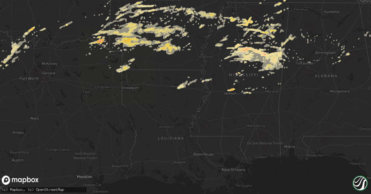
Hail Map in Alabama on April 20, 2011
Get this storm
April 20 map
$229
one time, instant access
Download today. No call, no setup
Keep the $229
Bought the map and want the full workflow? Apply the entire $229 to a subscription within 7 days. None of it is wasted.
Every map, not just this one
This buys you this map. Subscription and you get every map we run, in the markets you choose from a few cities to whole states to nationwide. Plus real-time alerts the moment a storm fires.
Contact data
Name, contact info, occupancy, even credit band for addresses in the footprint. You go from where it hit to who to call.
Become the source they trust
Unlimited branding weather history reports on demand. You already have the documented answer ready for the property owner, and you are the one who showed up with it.
Property data and RoofTrace estimates
Pull up any address you have got, its value and the exact code rules for that jurisdiction, straight from One Click Code. Then RoofTrace estimates the squares, pitch, and roof value, priced the way you price.
Storm reports in Alabama
Alabama
| Date | Description |
|---|---|
| 04/20/20113:10 PM CDT | A local report indicates 1.00 inch wind near HELENA |
| 04/20/201110:58 AM CDT | A local report indicates 1.00 inch wind near HELENA |
| 04/20/201110:57 AM CDT | Tree down near bb comer high school in sylacauga. Fire department was dispatched to remove the tree. |
| 04/20/201110:15 AM CDT | Trees and powerlines down in and around double springs. |
| 04/20/201110:10 AM CDT | A local report indicates 1.00 inch wind near HELENA |
| 04/20/20119:40 AM CDT | Roofs damaged at stone gate trailer park on lower coaling road. |
| 04/20/20119:40 AM CDT | Trees and powerlines down on 23rd terrace nw. |
| 04/20/20119:25 AM CDT | Trees and powerlines down near us highway 11 and buttermilk road. |
| 04/20/20119:25 AM CDT | Numerous trees and powerlines down near alabama highway 216 and kingsmill road. |
| 04/20/20119:15 AM CDT | Trees down at the entrance of summerville neighborhood. |
| 04/20/20119:10 AM CDT | Numerous trees down in the city of tuscaloosa. |
| 04/20/20119:08 AM CDT | Large tree down blocking lurleen wallace blvd south. |
| 04/20/20119:07 AM CDT | 74 mph gust recorded atop the courthouse in down town tuscaloosa. |
| 04/20/20119:05 AM CDT | Numerous homes damaged in the area of green grove drive. |
| 04/20/20119:01 AM CDT | 65 mph wind recorded atop the courthouse in downtown tuscaloosa. |
| 04/20/201112:50 AM CDT | Trees down on county road 61 near cullman lake. |
| 04/20/201112:32 AM CDT | Trees down in gallant |
| 04/20/201112:14 AM CDT | A small power outage was reported due to knocked down tree limbs or lightning. |
| 04/20/201112:14 AM CDT | Small tree limbs were knocked down on the guntersville peninsula area. |
| 04/20/201112:06 AM CDT | Tree down on the administration building at the city court apt on broadway road. |
| 04/20/201112:06 AM CDT | Tree donw in front of stemley school blocking road. |
| 04/19/201111:15 PM CDT | Trees were blown down at willow lake road and hepezba church road...and on woodland lake road...near the lake view community. |
| 04/19/201111:11 PM CDT | Trees down. |
| 04/19/201111:11 PM CDT | Tree down on cherry st. |
| 04/19/201111:10 PM CDT | Tree down blocking hwy 150 just south of shades crest road. |
| 04/19/201111:10 PM CDT | Multiple trees down from cr 223 northeast to cr 703. Time estimated from radar. |
| 04/19/201111:10 PM CDT | A tree was knocked onto a home on cr 775. |
| 04/19/201111:10 PM CDT | Tree down on i65 southbound just before alford ave exit. |
| 04/19/201111:10 PM CDT | A tree was knocked onto a home on cr 703. |
| 04/19/201111:00 PM CDT | Tree down on alliance road and taylors ferry rd in adamsville. |
| 04/19/201110:54 PM CDT | Tree blocking hwy 31 just of i65 at exit 287. |
| 04/19/201110:41 PM CDT | Numerous trees down across southern part of county. |
| 04/19/201110:40 PM CDT | A tree was blown down onto rue road. Trees were blown down on al-171 at the 22 mile marker. |
| 04/19/201110:36 PM CDT | Trees and powerlines down in and around cordova. |
| 04/19/201110:28 PM CDT | Trees and powerlines down in and around arley. |
| 04/19/201110:22 PM CDT | Trees down in the communities of curry and thatch. |
| 04/19/201110:19 PM CDT | Trees and powerlines down in and around black pond. |
| 04/19/201110:15 PM CDT | Trees and powerlines were blown down in the city of pickensville. Al-14 became temporarily impassable due to fallen trees. |
| 04/19/201110:15 PM CDT | Trees and powerlines down in and around double springs. |
| 04/19/201110:15 PM CDT | Trees down. |
| 04/19/201110:13 PM CDT | Numerous trees down across fayette county. |
| 04/19/201110:12 PM CDT | Numerous trees down in and around carbon hill. |
| 04/19/20119:53 PM CDT | Tree and powerline blocking highway 102 near the intersection of co rd 53. |
| 04/19/20119:53 PM CDT | Tree on house. |
| 04/19/20119:37 PM CDT | A large tree has fallen on a car along highway 278 in beaverton. The occupants of the vehicle were rescued without injuries. |
| 04/19/20119:30 PM CDT | At least seven reports of trees down due to thunderstorm winds. The reports were across the eastern half of franklin county between 930 pm and 1000 pm. |
| 04/19/20119:26 PM CDT | Trees down across county. |
| 04/19/20119:25 PM CDT | Tree limbs were knocked down which caused a power outage in spring valley. Time estimated by radar. |
| 04/19/20119:15 PM CDT | Trees down. |
| 04/19/20118:44 PM CDT | A local report indicates 1.00 inch wind near SULLIGENT |
| 04/19/20118:25 PM CDT | A local report indicates 1.00 inch wind near SULLIGENT |
All States Impacted by Hail Map on April 20, 2011
Cities Impacted by Hail Map on April 20, 2011
- Oxford, MS
- Abbeville, MS
- Porterville, MS
- Iraan, TX
- Banks, AR
- Warren, AR
- Summertown, TN
- Lawrenceburg, TN
- Hohenwald, TN
- Bogata, TX
- Savannah, TN
- Junction, TX
- Guin, AL
- Beaverton, AL
- Sulligent, AL
- Piedmont, AL
- Bearden, AR
- Sparkman, AR
- Camden, AR
- Clarksdale, MS
- Greenwood, AR
- Huntington, AR
- Lane, OK
- Caddo, OK
- Atoka, OK
- Caney, OK
- Stringtown, OK
- Conehatta, MS
- Eldorado, TX
- Jacksboro, TX
- New Albany, MS
- Guntown, MS
- Blue Springs, MS
- Jessieville, AR
- Marks, MS
- Tunica, MS
- Coahoma, MS
- Sledge, MS
- Marianna, AR
- Dundee, MS
- French Camp, MS
- Vaiden, MS
- Winona, MS
- Eupora, MS
- Kilmichael, MS
- Stewart, MS
- Clyde, TX
- Muenster, TX
- Norman, AR
- Chunky, MS
- Little Rock, MS
- Collinsville, MS
- Counce, TN
- Chico, TX
- Cedarbluff, MS
- Ballinger, TX
- Waynesboro, TN
- Christoval, TX
- Cascilla, MS
- Holcomb, MS
- Harvey, AR
- Ola, AR
- Perryville, AR
- Bluffton, AR
- Rover, AR
- Briggsville, AR
- Plainview, AR
- Danville, AR
- Gravelly, AR
- Lexa, AR
- Eden, TX
- Vancourt, TX
- Menard, TX
- Hazen, AR
- Nocona, TX
- Broken Bow, OK
- Quemado, TX
- Brackettville, TX
- Wright City, OK
- De Queen, AR
- Gillham, AR
- Lockesburg, AR
- Belzoni, MS
- Silver City, MS
- Keystone Heights, FL
- Starke, FL
- Aubrey, AR
- Marvell, AR
- Holly Grove, AR
- Brinkley, AR
- Idabel, OK
- Old Town, FL
- Branford, FL
- Eagle Pass, TX
- Waldron, AR
- Boles, AR
- Parks, AR
- Okolona, MS
- Bowie, TX
- Roosevelt, TX
- Sonora, TX
- Breckenridge, TX
- Graham, TX
- South Bend, TX
- North Little Rock, AR
- Trenton, FL
- Bell, FL
- Columbus, MS
- Morton, MS
- Coleman, TX
- Novice, TX
- Talpa, TX
- McCaskill, AR
- Saratoga, AR
- Blevins, AR
- Hope, AR
- Columbus, AR
- Mineral Springs, AR
- Ozan, AR
- Fulton, AR
- Prescott, AR
- Washington, AR
- Ashdown, AR
- Nashville, AR
- Emmet, AR
- Clarendon, AR
- Mena, AR
- Hampton, AR
- Carlisle, AR
- Lonoke, AR
- Mathiston, MS
- Ozona, TX
- Chiefland, FL
- McCarley, MS
- Walthall, MS
- Starkville, MS
- North Carrollton, MS
- Pheba, MS
- Mississippi State, MS
- Steens, MS
- Carrollton, MS
- Maben, MS
- Duck Hill, MS
- Brooksville, MS
- Crawford, MS
- Artesia, MS
- Sturgis, MS
- Macon, MS
- Louisville, MS
- De Valls Bluff, AR
- Rienzi, MS
- Glen, MS
- Burnsville, MS
- Booneville, MS
- Talladega, AL
- Munford, AL
- Baird, TX
- Cross Plains, TX
- Moran, TX
- Burkett, TX
- Cisco, TX
- Wilson, OK
- Monticello, AR
- Mill Creek, OK
- Madill, OK
- Mannsville, OK
- Ardmore, OK
- West Point, MS
- Gouldbusk, TX
- Lohn, TX
- Doole, TX
- Casa, AR
- Morrilton, AR
- Transylvania, LA
- Mer Rouge, LA
- Malvern, AR
- Newberry, FL
- Montague, TX
- Rayville, LA
- Oak Ridge, LA
- Monroe, LA
- Mayo, FL
- Haworth, OK
- Clarksville, TX
- Bagwell, TX
- Garvin, OK
- Sheridan, AR
- Grapevine, AR
- Carthage, AR
- Leola, AR
- White Hall, AR
- Pine Bluff, AR
- Weir, MS
- Ackerman, MS
- Bryson, TX
- Cleveland, MS
- Ruleville, MS
- Drew, MS
- Atkins, AR
- Lawtey, FL
- London, TX
- England, AR
- Scott, AR
- Walnut, MS
- Ashland, MS
- Michigan City, MS
- Ethel, MS
- West, MS
- Taylor, MS
- Interlachen, FL
- Hawthorne, FL
- Valera, TX
- Miles, TX
- Winters, TX
- Rowena, TX
- Woodson, TX
- New Boston, TX
- Itta Bena, MS
- Sidon, MS
- Gurdon, AR
- Orange Park, FL
- Jacksonville, FL
- Thornton, AR
- Fordyce, AR
- Melrose, FL
- Florahome, FL
- Royal, AR
- Paint Rock, TX
- Pottsville, AR
- Dardanelle, AR
- De Witt, AR
- Grenada, MS
- Greenwood, MS
- Houston, MS
- Jackson, MS
- Ridgeland, MS
- Madison, MS
- Tougaloo, MS
- Noxapater, MS
- Pontotoc, MS
- Randolph, MS
- Saint Jo, TX
- Sylacauga, AL
- Doddridge, AR
- Sallis, MS
- Winfield, AL
- Roland, AR
- Paron, AR
- Little Rock, AR
- Smithville, OK
- Pierson, FL
- Astor, FL
- Altoona, FL
- Goodman, MS
- Prairie, MS
- Crescent City, FL
- Welaka, FL
- Fort McCoy, FL
- Albany, TX
- Perrin, TX
- Anniston, AL
- Tutwiler, MS
- Charleston, MS
- Grand Junction, TN
- Saulsbury, TN
- Batesville, MS
- Hackett, AR
- Morriston, FL
- Bronson, FL
- McCool, MS
- Powder Springs, GA
- Marietta, GA
- Mereta, TX
- Eola, TX
- Micanopy, FL
- Anthony, FL
- Ocala, FL
- Citra, FL
- Detroit, TX
- Melvin, TX
- Preston, MS
- Elrod, AL
- Gordo, AL
- Loving, TX
- Marietta, OK
- Belden, MS
- Friendship, AR
- Donaldson, AR
- Amity, AR
- Arkadelphia, AR
- Brandon, MS
- Clinton, MS
- Big Lake, TX
- Cruger, MS
- Kirby, AR
- Glenwood, AR
- Caddo Gap, AR
- Langley, AR
- Horatio, AR
- Alleene, AR
- Okolona, AR
- Bluff City, AR
- Delight, AR
- Chidester, AR
- Shannon, MS
- Tupelo, MS
- Banner, MS
- Paris, MS
- Water Valley, MS
- Houlka, MS
- Bolivar, TN
- Middleton, TN
- Baldwyn, MS
- Dumas, MS
- Elaine, AR
- Merigold, MS
- Minter City, MS
- Boyle, MS
- Doddsville, MS
- Grady, AR
- Jasper, AL
- Millington, TN
- Schlater, MS
- San Angelo, TX
- Nashoba, OK
- Clayton, OK
- Mertzon, TX
- Eagletown, OK
- Ohatchee, AL
- Ragland, AL
- Aberdeen, MS
- Camden, MS
- Corinth, MS
- Bismarck, AR
- Williston, FL
- Story, AR
- Dumas, AR
- Green Cove Springs, FL
- Hot Springs National Park, AR
- Woodland, MS
- Vardaman, MS
- Mantee, MS
- Calhoun City, MS
- Lone Grove, OK
- Springer, OK
- Caledonia, MS
- Gattman, MS
- Hamilton, MS
- Umpire, AR
- Dierks, AR
- Mount Ida, AR
- Sims, AR
- Coldwater, MS
- Pickens, MS
- Vaughan, MS
- Saltillo, MS
- McCalla, AL
- Bellevue, TX
- Ringling, OK
- Epps, LA
- Cove, AR
- Hatfield, AR
- Watson, OK
- Vandervoort, AR
- Ethelsville, AL
- Carrollton, AL
- Thaxton, MS
- Etta, MS
- Scooba, MS
- De Kalb, MS
- Shuqualak, MS
- Kennedy, AL
- Fayette, AL
- Rolling Fork, MS
- Archer, FL
- Gainesville, FL
- Bruce, MS
- Aliceville, AL
- Abilene, TX
- Coila, MS
- Avery, TX
- Middleburg, FL
- Bridgeport, TX
- Tuscola, TX
- Buffalo Gap, TX
- Bradley, AR
- Ida, LA
- Atlanta, TX
- Bivins, TX
- Fouke, AR
- Rodessa, LA
- Northport, AL
- Coker, AL
- Star City, AR
- Yorktown, AR
- Texarkana, AR
- Lexington, MS
- Sarah, MS
- Lewisville, AR
- Garland City, AR
- Memphis, TN
- Nettleton, MS
- Alpine, AL
- Childersburg, AL
- Como, MS
- Sardis, MS
- Crenshaw, MS
- Lyon, MS
- Pioneer, LA
- Bauxite, AR
- Murfreesboro, AR
- Heavener, OK
- Gore Springs, MS
- Philadelphia, MS
- Pomona Park, FL
- Senatobia, MS
- Fort Smith, AR
- Rison, AR
- Sherwood, AR
- Jacksonville, AR
- Poplar Grove, AR
- Lake Providence, LA
- Mantachie, MS
- Canton, MS
- Paisley, FL
- Linden, TX
- Finger, TN
- Bethel Springs, TN
- Henderson, TN
- Pelahatchie, MS
- University, MS
- Waterford, MS
- Coffeeville, MS
- Arlington, TN
- Decatur, MS
- Casscoe, AR
- West Helena, AR
- Helena, AR
- Henrietta, TX
- Wilsonville, AL
- Columbiana, AL
- Buhl, AL
- Tishomingo, OK
- New Edinburg, AR
- Harrell, AR
- Wilmar, AR
- Ogden, AR
- Bonnerdale, AR
- Cross City, FL
- Hot Springs Village, AR
- Lonsdale, AR
- Forest, MS
- Hornsby, TN
- Saint Charles, AR
- Ethel, AR
- Grannis, AR
- Newhope, AR
- Altheimer, AR
- Wilton, AR
- Poyen, AR
- Valliant, OK
- Foreman, AR
- Kingsland, AR
- Pearcy, AR
- Stuttgart, AR
- Hickory Valley, TN
- Hayden, AL
- Warrior, AL
- Alvord, TX
- Cedartown, GA
- Marietta, TX
- Reform, AL
- Ashville, AL
- Odenville, AL
- Springville, AL
- Tucker, AR
- Vincent, AL
- Lauderdale, MS
- Howe, OK
- Poteau, OK
- Ecru, MS
- Coalgate, OK
- Nauvoo, AL
- Cleveland, AL
- Lincoln, AL
- Big Creek, MS
- Blue Mountain, MS
- Honobia, OK
- Mayersville, MS
- Fulton, MS
- Rockwood, TX
- Arley, AL
- Crane Hill, AL
- Humphrey, AR
- Carbon Hill, AL
- Roe, AR
- Hodgen, OK
- Bryceville, FL
- Forestburg, TX
- Greenwood Springs, MS
- Hamilton, AL
- De Kalb, TX
- Simms, TX
- Gainesville, TX
- Ringgold, TX
- Leon, OK
- Sunset, TX
- Belleview, FL
- O'Brien, FL
- Brookwood, AL
- Cottondale, AL
- Bryant, AR
- Palatka, FL
- Verona, MS
- Plantersville, MS
- Mooreville, MS
- Pittsboro, MS
- Reddick, FL
- Benton, AR
- Traskwood, AR
- Duncanville, AL
- Tillar, AR
- Michie, TN
- Stantonville, TN
- Olivehill, TN
- Lutts, TN
- Shiloh, TN
- Russellville, AR
- Oneonta, AL
- Haleyville, AL
- Columbia, TN
- Sterrett, AL
- Millport, AL
- Almyra, AR
- Bloomburg, TX
- Redfield, AR
- Hensley, AR
- Lynn, AL
- Little Rock Air Force Base, AR
- Tremont, MS
- Collinston, LA
- Snow Lake, AR
- Iuka, MS
- Carthage, MS
- Lake, MS
- Adamsville, TN
- Crump, TN
- Hampshire, TN
- Inglis, FL
- High Springs, FL
- Double Springs, AL
- Riverside, AL
- Pulaski, MS
- Wall, TX
- Uvalde, TX
- Mansfield, AR
- Eldridge, AL
- Blountsville, AL
- Eustis, FL
- Seville, FL
- Cave Spring, GA
- Hanceville, AL
- Overbrook, OK
- Hiram, GA
- Dallas, GA
- Satsuma, FL
- Midland, AR
- Ripley, MS
- Biscoe, AR
- Maumelle, AR
- Oden, AR
- Alexander, AR
- Wickes, AR
- Mabelvale, AR
- Bellefontaine, MS
- Vance, AL
- Townley, AL
- Oakman, AL
- Pell City, AL
- Remlap, AL


