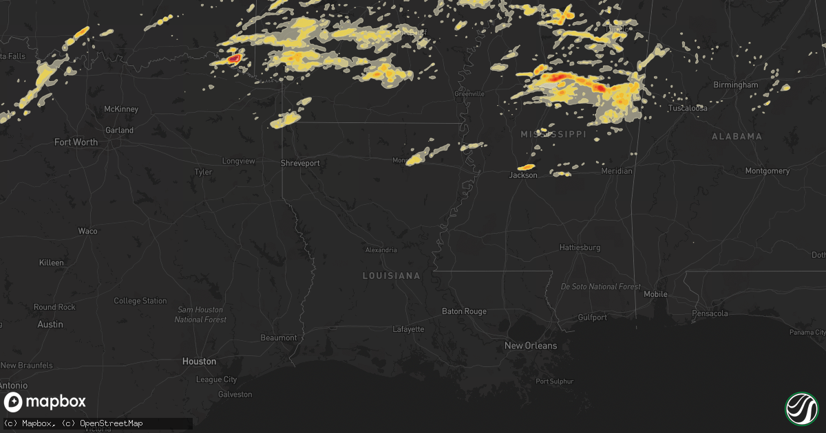
Hail Map on April 20, 2011
Get this storm
April 20 map
$229
one time, instant access
Download today. No call, no setup
Keep the $229
Bought the map and want the full workflow? Apply the entire $229 to a subscription within 7 days. None of it is wasted.
Every map, not just this one
This buys you this map. Subscription and you get every map we run, in the markets you choose from a few cities to whole states to nationwide. Plus real-time alerts the moment a storm fires.
Contact data
Name, contact info, occupancy, even credit band for addresses in the footprint. You go from where it hit to who to call.
Become the source they trust
Unlimited branding weather history reports on demand. You already have the documented answer ready for the property owner, and you are the one who showed up with it.
Property data and RoofTrace estimates
Pull up any address you have got, its value and the exact code rules for that jurisdiction, straight from One Click Code. Then RoofTrace estimates the squares, pitch, and roof value, priced the way you price.
States Impacted by Hail Map on April 20, 2011
Storm reports
Tennessee
| Date | Description |
|---|---|
| 04/20/20116:29 PM CDT | 1.25 inch hail reported just west of summertown between 614 pm and 629 pm |
| 04/20/20116:25 PM CDT | Quarter size hail reported on napier road in southeastern lewis county |
| 04/20/20116:18 PM CDT | A local report indicates 1.75 inch wind near 6 SSE HOHENWALD |
| 04/20/20116:05 PM CDT | One hail occurred estimated to have occurred between 550 pm and 605 pm. |
| 04/20/20115:50 PM CDT | Quarter sized hail on peaviner rd between middleton and bolivar . |
Arkansas
| Date | Description |
|---|---|
| 04/20/20116:45 PM CDT | Quarter size hail fell in gillham. |
| 04/20/20116:25 PM CDT | A local report indicates 1.00 inch wind near 2 S DIERKS |
| 04/20/20115:25 PM CDT | Quarter sized hail in shady acres development 3/4 mile south of west helenea airport |
| 04/20/20115:22 PM CDT | A local report indicates 1.00 inch wind near SULPHUR SPRINGS |
| 04/20/20115:04 PM CDT | A local report indicates 1.00 inch wind near SHERIDAN |
| 04/20/20113:53 PM CDT | A local report indicates 1.00 inch wind near 8 S DE VALLS BLUFF |
| 04/20/20113:47 PM CDT | Hail fell near taylor loop rd and heatherstone point. |
| 04/20/20113:47 PM CDT | Hail fell near taylor loop rd and heatherstone point. |
| 04/20/20113:40 PM CDT | Hail fell at kirk rd and chenall pkwy. |
| 04/20/20113:02 PM CDT | Up to golfball size hail at the intersection of 332 and hwy 278n |
| 04/20/20112:47 PM CDT | Volunteer fire dept reported hail busted out his windshield. |
| 04/20/20112:46 PM CDT | Hwy 27 north between nashville and mineral springs |
| 04/20/20112:35 PM CDT | Hail fell at intersection of hwy 71 and 28 east. |
| 04/20/20112:30 PM CDT | Hail fell at nlr nissan on landers rd. |
| 04/20/20112:25 PM CDT | Hail fell at mccain mall. |
| 04/20/20112:15 PM CDT | A local report indicates 1.00 inch wind near 3 S GREENWOOD |
| 04/20/20112:12 PM CDT | A local report indicates 1.00 inch wind near INK |
| 04/20/20112:08 PM CDT | Hail fell between napa valley rd and green mountain dr. |
| 04/20/201112:01 PM CDT | A local report indicates 1.00 inch wind near PARKS |
| 04/20/201111:49 AM CDT | Reported along hwy 71 south of boles. |
| 04/20/201112:46 AM CDT | A local report indicates 1.00 inch wind near PRESCOTT |
| 04/19/20119:50 PM CDT | Several trees down at farm to market and hwy 329. |
| 04/19/20118:13 PM CDT | A local report indicates 1.00 inch wind near BLACKWELL |
Oklahoma
| Date | Description |
|---|---|
| 04/20/20115:40 PM CDT | Quarter size hail fell from the 2nd severe thunderstorm that tracked across beavers bend state park near broken bow lake. |
| 04/20/20114:57 PM CDT | Quarter size hail falling at the beavers bend state park office near broken bow lake. |
| 04/20/20114:00 PM CDT | Reported by sheriffs office |
| 04/20/20113:57 PM CDT | Baseball sized hail at newspaper office in idabell |
| 04/20/20113:55 PM CDT | A local report indicates 2.00 inch wind near IDABEL |
| 04/20/20113:45 PM CDT | A local report indicates 1.75 inch wind near 1 E IDABEL |
| 04/20/20113:44 PM CDT | A local report indicates 1.00 inch wind near IDABEL |
| 04/19/201111:04 PM CDT | A local report indicates 1.75 inch wind near LONE GROVE |
Texas
| Date | Description |
|---|---|
| 04/20/20116:48 PM CDT | A local report indicates 1.00 inch wind near ROOSEVELT |
| 04/20/20116:45 PM CDT | Golfball to nearly baseball size hail falling 12 miles south of baird. |
| 04/20/20116:39 PM CDT | Ping pong ball size hail in novice. |
| 04/20/20116:37 PM CDT | Brief tornado touchdown along i-10 at mile marker 449. |
| 04/20/20116:11 PM CDT | Softball size hail damaging vehicles along i-10...just west of junction. |
| 04/20/20115:59 PM CDT | Larger than golfball size hail. Hail may be larger. Several huge dents in roof of car. |
| 04/20/20115:42 PM CDT | Quarter size hail along i-10 west of junction |
| 04/20/20115:40 PM CDT | Ping pong size hail falling in ballinger. |
| 04/20/20115:30 PM CDT | Quarter size hail in rowena |
| 04/20/20115:16 PM CDT | A local report indicates 1.00 inch wind near CLEO |
| 04/20/20115:06 PM CDT | Quarter size hail falling in cleo. |
| 04/20/20115:06 PM CDT | Quarter size hail falling in cleo. Still falling as of 516 pm. |
| 04/20/20115:01 PM CDT | Golfball size hail in paint rock. |
| 04/20/20114:55 PM CDT | A local report indicates 1.00 inch wind near 1 S CHRISTOVAL |
| 04/20/20114:50 PM CDT | Larger than baseball size hail falling along rr-765 east of eola. |
| 04/20/20114:45 PM CDT | 4 windows shattered...multiple holes in the siding of mobile home...all windows in truck knocked out...roof damage |
| 04/20/20114:40 PM CDT | Golball size hail just southwest of the interesection of us-83 and rr-765. |
| 04/20/20114:23 PM CDT | Quarter size hail along us-190 about 8 miles west of menard |
| 04/20/20114:04 PM CDT | Quarter size hail reported 8 miles north of menard |
| 04/19/201111:50 PM CDT | Quarter size hail. |
| 04/19/201111:36 PM CDT | Dime to golfball hail in brackettville. |
| 04/19/201111:30 PM CDT | Half dollar to hen egg size hail reported near brackettville. Damage to cars and roof shingles. |
| 04/19/201111:15 PM CDT | Quarter size hail. |
| 04/19/201110:19 PM CDT | Quarter size hail reported at lake nocona |
| 04/19/201110:00 PM CDT | Quarter size hail 1 mi n of montague on hwy 59 |
| 04/19/201110:00 PM CDT | Quarter size hail 1 mi n of montague |
| 04/19/20119:37 PM CDT | Quarter size hail covering the ground in bowie |
| 04/19/20119:35 PM CDT | Quarter size hail reported at amon carter lake |
| 04/19/20119:15 PM CDT | A local report indicates 1.75 inch wind near 5 E OZONA |
| 04/19/20118:42 PM CDT | A local report indicates 1.00 inch wind near IRAAN |
| 04/19/20118:35 PM CDT | Quarter size hail in south bend |
| 04/19/20118:32 PM CDT | Vehicle windows damaged |
| 04/19/20117:15 PM CDT | A local report indicates 1.00 inch wind near PUTNAM |
| 04/19/20117:10 PM CDT | A local report indicates 1.00 inch wind near CLYDE |
| 04/19/20117:04 PM CDT | Hail measured at billiard ball size |
| 04/19/20117:00 PM CDT | Hail 1.5 inches in diameter. |
Georgia
| Date | Description |
|---|---|
| 04/20/20117:22 AM CDT | Gilmer county 911 relayed a report of a tree down in ellijay. |
| 04/20/20112:20 AM CDT | Dispatch center reported 5 trees and 5 powerlines down throughout the county. |
| 04/20/20111:53 AM CDT | A few trees down on pat mell road. Tree fell on car. |
| 04/20/20111:39 AM CDT | One tree down on village drive. |
| 04/20/20111:20 AM CDT | The 911 center reported numerous trees and powerlines down countywide. |
| 04/19/20118:25 PM CDT | Large branches and top of pine blown down off germany road in camp dixie. |
| 04/19/20118:25 PM CDT | Tree blown down at heavens landing airpark subdivision. |
Mississippi
| Date | Description |
|---|---|
| 04/20/20116:59 PM CDT | A local report indicates 1.00 inch wind near 4 S HOLCOMB |
| 04/20/20116:55 PM CDT | A local report indicates 1.00 inch wind near VAIDEN |
| 04/20/20116:51 PM CDT | Golf ball hail in downtown oxford around jackson street. |
| 04/20/20116:50 PM CDT | Quarter hail on campus of university of mississippi |
| 04/20/20116:48 PM CDT | Golf ball hail 1 mile west of city limits of oxford |
| 04/20/20116:35 PM CDT | Half dollar to tennis ball hail near duck hill. |
| 04/20/20116:25 PM CDT | A local report indicates 1.00 inch wind near ELLIOTT |
| 04/20/20116:15 PM CDT | Multiple trees downed between carrollton and winona. |
| 04/20/20116:15 PM CDT | Trees down north of batesville. |
| 04/20/20115:53 PM CDT | A local report indicates 1.25 inch wind near CARROLLTON |
| 04/20/20115:40 PM CDT | Winds estimated at 60 mph in blue springs. |
| 04/20/20115:39 PM CDT | A local report indicates 1.00 inch wind near 6 W CARROLLTON |
| 04/20/20115:35 PM CDT | Reported in the highland plantation area |
| 04/20/20115:20 PM CDT | Quarter to golf ball size hail |
| 04/20/20114:58 PM CDT | Sizes ranging from half inch to golf ball |
| 04/20/20114:55 PM CDT | Quarter and nickel sized hail covering ground at home located at 3226 kendrick rd corinth. |
| 04/20/20114:55 PM CDT | Quarter to half dollar sized hail covering steps of mobile home on hwy 348 |
| 04/20/20114:40 PM CDT | A local report indicates 1.75 inch wind near 6 W STARKVILLE |
| 04/20/20114:30 PM CDT | Sizes ranging from golfball to baseball |
| 04/20/20113:48 PM CDT | A local report indicates 1.75 inch wind near 2 NW SHERWOOD |
| 04/20/20113:40 PM CDT | Sizes ranging from dime to quarter |
| 04/20/20113:15 PM CDT | A local report indicates 1.75 inch wind near WALTHALL |
| 04/20/20113:00 PM CDT | Multiple reports of golf ball size hail over western webster county |
| 04/20/20112:20 PM CDT | Reported in the red hill area |
| 04/20/20112:20 PM CDT | Quarter size hail covering the ground |
| 04/20/20112:15 PM CDT | A local report indicates 1.75 inch wind near DUCK HILL |
| 04/20/20112:05 PM CDT | Quarter size hail reported at the intersection of hwy 45 and main street in verona. |
| 04/20/20112:05 PM CDT | A local report indicates 1.00 inch wind near ELLIOTT |
| 04/20/20112:00 PM CDT | A local report indicates 1.50 inch wind near VERONA |
| 04/20/20111:55 PM CDT | A local report indicates 1.75 inch wind near JEFFERSON |
| 04/20/20111:45 PM CDT | A local report indicates 1.75 inch wind near 3 NNW JEFFERSON |
| 04/20/20111:40 PM CDT | A local report indicates 1.75 inch wind near 4 NW JEFFERSON |
| 04/20/20111:00 PM CDT | A local report indicates 1.00 inch wind near MONEY |
| 04/20/201112:29 PM CDT | Some trees were blown down on open pasture in town. |
| 04/20/201112:22 PM CDT | Ping pong ball size hail in the town of wallfield. |
| 04/20/201111:58 AM CDT | A local report indicates 1.00 inch wind near RANDOLPH |
| 04/20/201111:29 AM CDT | A local report indicates 1.25 inch wind near 3 S TULA |
| 04/20/201111:07 AM CDT | A local report indicates 1.00 inch wind near 2 N PARIS |
| 04/20/201110:54 AM CDT | Hail slightly larger than quarter size was reported by a storm spotter near the town of taylor. |
| 04/20/201110:42 AM CDT | Golf ball size hail reported by a storm spotter near college hill...relayed by emergency manager. |
| 04/20/20117:04 AM CDT | A local report indicates 1.00 inch wind near 2 SW STARKVILLE |
| 04/20/201112:04 AM CDT | A local report indicates 1.00 inch wind near 4 S FOREST |
| 04/19/201110:10 PM CDT | Reported at highland colony parkway...old canton road and highway 51 |
| 04/19/201110:04 PM CDT | Ping pong ball size hail just west of interstate 55 in ridgeland |
| 04/19/20119:43 PM CDT | Couple of trees down in macon |
| 04/19/20119:34 PM CDT | 3 to 4 trees down in town of brooksville. |
| 04/19/20119:30 PM CDT | A local report indicates 1.25 inch wind near 3 NW MASHULAVILLE |
| 04/19/20119:15 PM CDT | Three trees knocked down |
| 04/19/20119:13 PM CDT | Quarter sized hail in amory |
| 04/19/20119:10 PM CDT | Tree down on school road |
| 04/19/20119:10 PM CDT | Tree down across northwood forrest road |
| 04/19/20119:10 PM CDT | A local report indicates 1.00 inch wind near AMORY |
| 04/19/20119:10 PM CDT | Power line down in front of caledonia high school on wolfe road |
| 04/19/20119:06 PM CDT | Tree down on a house on old crawford road |
| 04/19/20119:00 PM CDT | Several trees down over northern monroe county. |
| 04/19/20119:00 PM CDT | Trees down county wide. |
| 04/19/20118:57 PM CDT | Trees down...some on power lines |
| 04/19/20118:52 PM CDT | Tree down across northwood forrest road |
| 04/19/20118:52 PM CDT | Trees down on hwy 12 west of kosciusko. |
| 04/19/20118:50 PM CDT | Trees down on southeast side of starkville |
| 04/19/20118:50 PM CDT | Tree down on house on cedar bluff loop |
| 04/19/20118:48 PM CDT | A local report indicates 1.75 inch wind near COLUMBUS |
| 04/19/20118:45 PM CDT | Trees down in the northwest and west-central part of the county. Location approximate. |
| 04/19/20118:42 PM CDT | Reported at the county eoc |
| 04/19/20118:35 PM CDT | Reported along alabama st...also penny size hail falling on nashville ferry rd. |
| 04/19/20118:30 PM CDT | Several trees down in town |
| 04/19/20118:30 PM CDT | Trees down across the southern end of lee county. |
| 04/19/20118:25 PM CDT | Trees down across the county. One fell on a house |
| 04/19/20118:15 PM CDT | Estimated winds of 60 mph blowing through town of shannon |
| 04/19/20118:10 PM CDT | Trees and power lines down...homes damaged. A tree was uprooted on highway 8 which pulled up a gas line. |
| 04/19/20118:10 PM CDT | A couple trees were downed along cr 3122 |
| 04/19/20118:09 PM CDT | Storm survey found a 3.5 mile tornado path with a max width of 150 yards 1 s of tomnolen to 2.7 nne of tomnolen. Hardwood and pine tree damage...along with roof damage |
| 04/19/20118:08 PM CDT | Several trees down across roads in the stewart community. |
| 04/19/20118:00 PM CDT | *** 1 inj *** trees down county wide. One tree fell on a home in houston resulting in injuries to a child. The child was treated for cuts and briuses and released. |
| 04/19/20117:58 PM CDT | Several trees down in city |
| 04/19/20117:55 PM CDT | Tree down on a car and a home. Also...tree down blocking highway 12 north of sturgis |
| 04/19/20117:50 PM CDT | A tree was downed along 20th st n. |
| 04/19/20117:40 PM CDT | Several trees and power lines downed across the city of grenada...and in grenada county east of the city. |
| 04/19/20117:40 PM CDT | Several trees down across roads in the duck hill area. |
| 04/19/20117:38 PM CDT | Several trees down north of seven pines community. |
| 04/19/20117:35 PM CDT | Reported along tarlton rd |
| 04/19/20117:35 PM CDT | Power poles snapped...trees downed...and a porch blown off a house |
| 04/19/20117:35 PM CDT | A local report indicates 1.75 inch wind near KILMICHAEL |
| 04/19/20117:22 PM CDT | Tree knocked down on to a mobile home |
| 04/19/20117:12 PM CDT | Trees down in the area...one fell on a house trailer. Possible tornado based on sightings |
| 04/19/20117:10 PM CDT | Tree down on top of a mobile home |
| 04/19/20117:05 PM CDT | Reported along gillon rd |
| 04/19/20117:05 PM CDT | Numerous trees down some across roads. Two trees fell on a house...one caused major damage and one minor damage. Possible tornado from reports of sightings |
| 04/19/20117:03 PM CDT | A tree fell on a gas meter behind the sumner post office creating a gas leak. |
| 04/19/20117:02 PM CDT | A local report indicates 1.00 inch wind near 1 S HOLCOMB |
| 04/19/20117:00 PM CDT | A local report indicates 2.50 inch wind near SWEATMAN |
| 04/19/20117:00 PM CDT | Golf ball hail on hwy 30 |
Florida
| Date | Description |
|---|---|
| 04/20/20115:35 PM CDT | Nickel to quarter size hail reported by the general public west of middleburg. Localized flooding also reported. |
| 04/20/20115:00 PM CDT | Large oak tree blown over by thunderstorm winds on central avenue in crescent city. Time estimated by radar. |
| 04/20/20114:15 PM CDT | Ocala electric employee reported ping pong ball sized hail just north of ocala. |
| 04/20/20114:15 PM CDT | Lawn furniture tossed around yard. 16 foot ladder thrown 12 feet across boat slip. Time estimated by radar. |
| 04/20/20114:08 PM CDT | Ocala electric employee relayed a report of golf ball sized hail in anthony. |
| 04/20/20114:05 PM CDT | Quarter size hail reported by spotter at intersection of florida route 100 and route 21 near keystone heights. Also reported small limbs down. |
| 04/20/20113:56 PM CDT | Emergency manager reported a tree down at sw 194th st and sr45. |
| 04/20/20113:35 PM CDT | Emergency manager reported a tree down at sw 194th st and sr45. Time estimated by radar. |
| 04/20/20113:10 PM CDT | Quarter sized hail relayed by emergency management. |
| 04/20/20113:00 PM CDT | 911 reported trees down in the waccasassa lake area. Time estimated from radar. |
Utah
| Date | Description |
|---|---|
| 04/20/20111:10 AM CDT | Upper cedar mountain sensor |
| 04/20/20111:10 AM CDT | Playa station sensor |
Alabama
| Date | Description |
|---|---|
| 04/20/20113:10 PM CDT | A local report indicates 1.00 inch wind near HELENA |
| 04/20/201110:58 AM CDT | A local report indicates 1.00 inch wind near HELENA |
| 04/20/201110:57 AM CDT | Tree down near bb comer high school in sylacauga. Fire department was dispatched to remove the tree. |
| 04/20/201110:15 AM CDT | Trees and powerlines down in and around double springs. |
| 04/20/201110:10 AM CDT | A local report indicates 1.00 inch wind near HELENA |
| 04/20/20119:40 AM CDT | Roofs damaged at stone gate trailer park on lower coaling road. |
| 04/20/20119:40 AM CDT | Trees and powerlines down on 23rd terrace nw. |
| 04/20/20119:25 AM CDT | Numerous trees and powerlines down near alabama highway 216 and kingsmill road. |
| 04/20/20119:25 AM CDT | Trees and powerlines down near us highway 11 and buttermilk road. |
| 04/20/20119:15 AM CDT | Trees down at the entrance of summerville neighborhood. |
| 04/20/20119:10 AM CDT | Numerous trees down in the city of tuscaloosa. |
| 04/20/20119:08 AM CDT | Large tree down blocking lurleen wallace blvd south. |
| 04/20/20119:07 AM CDT | 74 mph gust recorded atop the courthouse in down town tuscaloosa. |
| 04/20/20119:05 AM CDT | Numerous homes damaged in the area of green grove drive. |
| 04/20/20119:01 AM CDT | 65 mph wind recorded atop the courthouse in downtown tuscaloosa. |
| 04/20/201112:50 AM CDT | Trees down on county road 61 near cullman lake. |
| 04/20/201112:32 AM CDT | Trees down in gallant |
| 04/20/201112:14 AM CDT | A small power outage was reported due to knocked down tree limbs or lightning. |
| 04/20/201112:14 AM CDT | Small tree limbs were knocked down on the guntersville peninsula area. |
| 04/20/201112:06 AM CDT | Tree donw in front of stemley school blocking road. |
| 04/20/201112:06 AM CDT | Tree down on the administration building at the city court apt on broadway road. |
| 04/19/201111:15 PM CDT | Trees were blown down at willow lake road and hepezba church road...and on woodland lake road...near the lake view community. |
| 04/19/201111:11 PM CDT | Trees down. |
| 04/19/201111:11 PM CDT | Tree down on cherry st. |
| 04/19/201111:10 PM CDT | Tree down blocking hwy 150 just south of shades crest road. |
| 04/19/201111:10 PM CDT | Multiple trees down from cr 223 northeast to cr 703. Time estimated from radar. |
| 04/19/201111:10 PM CDT | Tree down on i65 southbound just before alford ave exit. |
| 04/19/201111:10 PM CDT | A tree was knocked onto a home on cr 703. |
| 04/19/201111:10 PM CDT | A tree was knocked onto a home on cr 775. |
| 04/19/201111:00 PM CDT | Tree down on alliance road and taylors ferry rd in adamsville. |
| 04/19/201110:54 PM CDT | Tree blocking hwy 31 just of i65 at exit 287. |
| 04/19/201110:41 PM CDT | Numerous trees down across southern part of county. |
| 04/19/201110:40 PM CDT | A tree was blown down onto rue road. Trees were blown down on al-171 at the 22 mile marker. |
| 04/19/201110:36 PM CDT | Trees and powerlines down in and around cordova. |
| 04/19/201110:28 PM CDT | Trees and powerlines down in and around arley. |
| 04/19/201110:22 PM CDT | Trees down in the communities of curry and thatch. |
| 04/19/201110:19 PM CDT | Trees and powerlines down in and around black pond. |
| 04/19/201110:15 PM CDT | Trees and powerlines were blown down in the city of pickensville. Al-14 became temporarily impassable due to fallen trees. |
| 04/19/201110:15 PM CDT | Trees and powerlines down in and around double springs. |
| 04/19/201110:15 PM CDT | Trees down. |
| 04/19/201110:13 PM CDT | Numerous trees down across fayette county. |
| 04/19/201110:12 PM CDT | Numerous trees down in and around carbon hill. |
| 04/19/20119:53 PM CDT | Tree and powerline blocking highway 102 near the intersection of co rd 53. |
| 04/19/20119:53 PM CDT | Tree on house. |
| 04/19/20119:37 PM CDT | A large tree has fallen on a car along highway 278 in beaverton. The occupants of the vehicle were rescued without injuries. |
| 04/19/20119:30 PM CDT | At least seven reports of trees down due to thunderstorm winds. The reports were across the eastern half of franklin county between 930 pm and 1000 pm. |
| 04/19/20119:26 PM CDT | Trees down across county. |
| 04/19/20119:25 PM CDT | Tree limbs were knocked down which caused a power outage in spring valley. Time estimated by radar. |
| 04/19/20119:15 PM CDT | Trees down. |
| 04/19/20118:44 PM CDT | A local report indicates 1.00 inch wind near SULLIGENT |
| 04/19/20118:25 PM CDT | A local report indicates 1.00 inch wind near SULLIGENT |
Cities Impacted by Hail Map on April 20, 2011
- Oxford, MS
- Abbeville, MS
- Porterville, MS
- Iraan, TX
- Banks, AR
- Warren, AR
- Summertown, TN
- Lawrenceburg, TN
- Hohenwald, TN
- Bogata, TX
- Savannah, TN
- Junction, TX
- Guin, AL
- Beaverton, AL
- Sulligent, AL
- Piedmont, AL
- Bearden, AR
- Sparkman, AR
- Camden, AR
- Clarksdale, MS
- Greenwood, AR
- Huntington, AR
- Lane, OK
- Caddo, OK
- Atoka, OK
- Caney, OK
- Stringtown, OK
- Conehatta, MS
- Eldorado, TX
- Jacksboro, TX
- New Albany, MS
- Guntown, MS
- Blue Springs, MS
- Jessieville, AR
- Marks, MS
- Tunica, MS
- Coahoma, MS
- Sledge, MS
- Marianna, AR
- Dundee, MS
- French Camp, MS
- Vaiden, MS
- Winona, MS
- Eupora, MS
- Kilmichael, MS
- Stewart, MS
- Clyde, TX
- Muenster, TX
- Norman, AR
- Chunky, MS
- Little Rock, MS
- Collinsville, MS
- Counce, TN
- Chico, TX
- Cedarbluff, MS
- Ballinger, TX
- Waynesboro, TN
- Christoval, TX
- Cascilla, MS
- Holcomb, MS
- Harvey, AR
- Ola, AR
- Perryville, AR
- Bluffton, AR
- Rover, AR
- Briggsville, AR
- Plainview, AR
- Danville, AR
- Gravelly, AR
- Lexa, AR
- Eden, TX
- Vancourt, TX
- Menard, TX
- Hazen, AR
- Nocona, TX
- Broken Bow, OK
- Quemado, TX
- Brackettville, TX
- Wright City, OK
- De Queen, AR
- Gillham, AR
- Lockesburg, AR
- Belzoni, MS
- Silver City, MS
- Keystone Heights, FL
- Starke, FL
- Aubrey, AR
- Marvell, AR
- Holly Grove, AR
- Brinkley, AR
- Idabel, OK
- Old Town, FL
- Branford, FL
- Eagle Pass, TX
- Waldron, AR
- Boles, AR
- Parks, AR
- Okolona, MS
- Bowie, TX
- Roosevelt, TX
- Sonora, TX
- Breckenridge, TX
- Graham, TX
- South Bend, TX
- North Little Rock, AR
- Trenton, FL
- Bell, FL
- Columbus, MS
- Morton, MS
- Coleman, TX
- Novice, TX
- Talpa, TX
- McCaskill, AR
- Saratoga, AR
- Blevins, AR
- Hope, AR
- Columbus, AR
- Mineral Springs, AR
- Ozan, AR
- Fulton, AR
- Prescott, AR
- Washington, AR
- Ashdown, AR
- Nashville, AR
- Emmet, AR
- Clarendon, AR
- Mena, AR
- Hampton, AR
- Carlisle, AR
- Lonoke, AR
- Mathiston, MS
- Ozona, TX
- Chiefland, FL
- McCarley, MS
- Walthall, MS
- Starkville, MS
- North Carrollton, MS
- Pheba, MS
- Mississippi State, MS
- Steens, MS
- Carrollton, MS
- Maben, MS
- Duck Hill, MS
- Brooksville, MS
- Crawford, MS
- Artesia, MS
- Sturgis, MS
- Macon, MS
- Louisville, MS
- De Valls Bluff, AR
- Rienzi, MS
- Glen, MS
- Burnsville, MS
- Booneville, MS
- Talladega, AL
- Munford, AL
- Baird, TX
- Cross Plains, TX
- Moran, TX
- Burkett, TX
- Cisco, TX
- Wilson, OK
- Monticello, AR
- Mill Creek, OK
- Madill, OK
- Mannsville, OK
- Ardmore, OK
- West Point, MS
- Gouldbusk, TX
- Lohn, TX
- Doole, TX
- Casa, AR
- Morrilton, AR
- Transylvania, LA
- Mer Rouge, LA
- Malvern, AR
- Newberry, FL
- Montague, TX
- Rayville, LA
- Oak Ridge, LA
- Monroe, LA
- Mayo, FL
- Haworth, OK
- Clarksville, TX
- Bagwell, TX
- Garvin, OK
- Sheridan, AR
- Grapevine, AR
- Carthage, AR
- Leola, AR
- White Hall, AR
- Pine Bluff, AR
- Weir, MS
- Ackerman, MS
- Bryson, TX
- Cleveland, MS
- Ruleville, MS
- Drew, MS
- Atkins, AR
- Lawtey, FL
- London, TX
- England, AR
- Scott, AR
- Walnut, MS
- Ashland, MS
- Michigan City, MS
- Ethel, MS
- West, MS
- Taylor, MS
- Interlachen, FL
- Hawthorne, FL
- Valera, TX
- Miles, TX
- Winters, TX
- Rowena, TX
- Woodson, TX
- New Boston, TX
- Itta Bena, MS
- Sidon, MS
- Gurdon, AR
- Orange Park, FL
- Jacksonville, FL
- Thornton, AR
- Fordyce, AR
- Melrose, FL
- Florahome, FL
- Royal, AR
- Paint Rock, TX
- Pottsville, AR
- Dardanelle, AR
- De Witt, AR
- Grenada, MS
- Greenwood, MS
- Houston, MS
- Jackson, MS
- Ridgeland, MS
- Madison, MS
- Tougaloo, MS
- Noxapater, MS
- Pontotoc, MS
- Randolph, MS
- Saint Jo, TX
- Sylacauga, AL
- Doddridge, AR
- Sallis, MS
- Winfield, AL
- Roland, AR
- Paron, AR
- Little Rock, AR
- Smithville, OK
- Pierson, FL
- Astor, FL
- Altoona, FL
- Goodman, MS
- Prairie, MS
- Crescent City, FL
- Welaka, FL
- Fort McCoy, FL
- Albany, TX
- Perrin, TX
- Anniston, AL
- Tutwiler, MS
- Charleston, MS
- Grand Junction, TN
- Saulsbury, TN
- Batesville, MS
- Hackett, AR
- Morriston, FL
- Bronson, FL
- McCool, MS
- Powder Springs, GA
- Marietta, GA
- Mereta, TX
- Eola, TX
- Micanopy, FL
- Anthony, FL
- Ocala, FL
- Citra, FL
- Detroit, TX
- Melvin, TX
- Preston, MS
- Elrod, AL
- Gordo, AL
- Loving, TX
- Marietta, OK
- Belden, MS
- Friendship, AR
- Donaldson, AR
- Amity, AR
- Arkadelphia, AR
- Brandon, MS
- Clinton, MS
- Big Lake, TX
- Cruger, MS
- Kirby, AR
- Glenwood, AR
- Caddo Gap, AR
- Langley, AR
- Horatio, AR
- Alleene, AR
- Okolona, AR
- Bluff City, AR
- Delight, AR
- Chidester, AR
- Shannon, MS
- Tupelo, MS
- Banner, MS
- Paris, MS
- Water Valley, MS
- Houlka, MS
- Bolivar, TN
- Middleton, TN
- Baldwyn, MS
- Dumas, MS
- Elaine, AR
- Merigold, MS
- Minter City, MS
- Boyle, MS
- Doddsville, MS
- Grady, AR
- Jasper, AL
- Millington, TN
- Schlater, MS
- San Angelo, TX
- Nashoba, OK
- Clayton, OK
- Mertzon, TX
- Eagletown, OK
- Ohatchee, AL
- Ragland, AL
- Aberdeen, MS
- Camden, MS
- Corinth, MS
- Bismarck, AR
- Williston, FL
- Story, AR
- Dumas, AR
- Green Cove Springs, FL
- Hot Springs National Park, AR
- Woodland, MS
- Vardaman, MS
- Mantee, MS
- Calhoun City, MS
- Lone Grove, OK
- Springer, OK
- Caledonia, MS
- Gattman, MS
- Hamilton, MS
- Umpire, AR
- Dierks, AR
- Mount Ida, AR
- Sims, AR
- Coldwater, MS
- Pickens, MS
- Vaughan, MS
- Saltillo, MS
- McCalla, AL
- Bellevue, TX
- Ringling, OK
- Epps, LA
- Cove, AR
- Hatfield, AR
- Watson, OK
- Vandervoort, AR
- Ethelsville, AL
- Carrollton, AL
- Thaxton, MS
- Etta, MS
- Scooba, MS
- De Kalb, MS
- Shuqualak, MS
- Kennedy, AL
- Fayette, AL
- Rolling Fork, MS
- Archer, FL
- Gainesville, FL
- Bruce, MS
- Aliceville, AL
- Abilene, TX
- Coila, MS
- Avery, TX
- Middleburg, FL
- Bridgeport, TX
- Tuscola, TX
- Buffalo Gap, TX
- Bradley, AR
- Ida, LA
- Atlanta, TX
- Bivins, TX
- Fouke, AR
- Rodessa, LA
- Northport, AL
- Coker, AL
- Star City, AR
- Yorktown, AR
- Texarkana, AR
- Lexington, MS
- Sarah, MS
- Lewisville, AR
- Garland City, AR
- Memphis, TN
- Nettleton, MS
- Alpine, AL
- Childersburg, AL
- Como, MS
- Sardis, MS
- Crenshaw, MS
- Lyon, MS
- Pioneer, LA
- Bauxite, AR
- Murfreesboro, AR
- Heavener, OK
- Gore Springs, MS
- Philadelphia, MS
- Pomona Park, FL
- Senatobia, MS
- Fort Smith, AR
- Rison, AR
- Sherwood, AR
- Jacksonville, AR
- Poplar Grove, AR
- Lake Providence, LA
- Mantachie, MS
- Canton, MS
- Paisley, FL
- Linden, TX
- Finger, TN
- Bethel Springs, TN
- Henderson, TN
- Pelahatchie, MS
- University, MS
- Waterford, MS
- Coffeeville, MS
- Arlington, TN
- Decatur, MS
- Casscoe, AR
- West Helena, AR
- Helena, AR
- Henrietta, TX
- Wilsonville, AL
- Columbiana, AL
- Buhl, AL
- Tishomingo, OK
- New Edinburg, AR
- Harrell, AR
- Wilmar, AR
- Ogden, AR
- Bonnerdale, AR
- Cross City, FL
- Hot Springs Village, AR
- Lonsdale, AR
- Forest, MS
- Hornsby, TN
- Saint Charles, AR
- Ethel, AR
- Grannis, AR
- Newhope, AR
- Altheimer, AR
- Wilton, AR
- Poyen, AR
- Valliant, OK
- Foreman, AR
- Kingsland, AR
- Pearcy, AR
- Stuttgart, AR
- Hickory Valley, TN
- Hayden, AL
- Warrior, AL
- Alvord, TX
- Cedartown, GA
- Marietta, TX
- Reform, AL
- Ashville, AL
- Odenville, AL
- Springville, AL
- Tucker, AR
- Vincent, AL
- Lauderdale, MS
- Howe, OK
- Poteau, OK
- Ecru, MS
- Coalgate, OK
- Nauvoo, AL
- Cleveland, AL
- Lincoln, AL
- Big Creek, MS
- Blue Mountain, MS
- Honobia, OK
- Mayersville, MS
- Fulton, MS
- Rockwood, TX
- Arley, AL
- Crane Hill, AL
- Humphrey, AR
- Carbon Hill, AL
- Roe, AR
- Hodgen, OK
- Bryceville, FL
- Forestburg, TX
- Greenwood Springs, MS
- Hamilton, AL
- De Kalb, TX
- Simms, TX
- Gainesville, TX
- Ringgold, TX
- Leon, OK
- Sunset, TX
- Belleview, FL
- O'Brien, FL
- Brookwood, AL
- Cottondale, AL
- Bryant, AR
- Palatka, FL
- Verona, MS
- Plantersville, MS
- Mooreville, MS
- Pittsboro, MS
- Reddick, FL
- Benton, AR
- Traskwood, AR
- Duncanville, AL
- Tillar, AR
- Michie, TN
- Stantonville, TN
- Olivehill, TN
- Lutts, TN
- Shiloh, TN
- Russellville, AR
- Oneonta, AL
- Haleyville, AL
- Columbia, TN
- Sterrett, AL
- Millport, AL
- Almyra, AR
- Bloomburg, TX
- Redfield, AR
- Hensley, AR
- Lynn, AL
- Little Rock Air Force Base, AR
- Tremont, MS
- Collinston, LA
- Snow Lake, AR
- Iuka, MS
- Carthage, MS
- Lake, MS
- Adamsville, TN
- Crump, TN
- Hampshire, TN
- Inglis, FL
- High Springs, FL
- Double Springs, AL
- Riverside, AL
- Pulaski, MS
- Wall, TX
- Uvalde, TX
- Mansfield, AR
- Eldridge, AL
- Blountsville, AL
- Eustis, FL
- Seville, FL
- Cave Spring, GA
- Hanceville, AL
- Overbrook, OK
- Hiram, GA
- Dallas, GA
- Satsuma, FL
- Midland, AR
- Ripley, MS
- Biscoe, AR
- Maumelle, AR
- Oden, AR
- Alexander, AR
- Wickes, AR
- Mabelvale, AR
- Bellefontaine, MS
- Vance, AL
- Townley, AL
- Oakman, AL
- Pell City, AL
- Remlap, AL