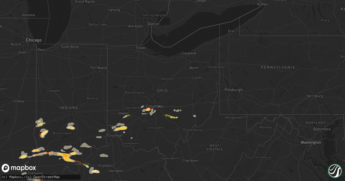
Hail Map in Ohio on April 16, 2013
Get this storm
April 16 map
$229
one time, instant access
Download today. No call, no setup
Keep the $229
Bought the map and want the full workflow? Apply the entire $229 to a subscription within 7 days. None of it is wasted.
Every map, not just this one
This buys you this map. Subscription and you get every map we run, in the markets you choose from a few cities to whole states to nationwide. Plus real-time alerts the moment a storm fires.
Contact data
Name, contact info, occupancy, even credit band for addresses in the footprint. You go from where it hit to who to call.
Become the source they trust
Unlimited branding weather history reports on demand. You already have the documented answer ready for the property owner, and you are the one who showed up with it.
Property data and RoofTrace estimates
Pull up any address you have got, its value and the exact code rules for that jurisdiction, straight from One Click Code. Then RoofTrace estimates the squares, pitch, and roof value, priced the way you price.
Storm reports in Ohio
Ohio
| Date | Description |
|---|---|
| 04/16/20136:29 PM CDT | A local report indicates 1.00 inch wind near SHAWNEE |
| 04/16/20135:55 PM CDT | One tree down on power line in newton township |
| 04/16/20135:53 PM CDT | A local report indicates 1.00 inch wind near LANCASTER |
| 04/16/20135:35 PM CDT | Heavy wooden playset tipped over |
| 04/16/20135:23 PM CDT | A local report indicates 1.00 inch wind near 1 NNW SOUTH OLIVE |
| 04/16/20135:01 PM CDT | Anderson township area. Power poles blown down. |
| 04/16/20134:38 PM CDT | Relayed by state ema |
| 04/16/20134:32 PM CDT | A local report indicates 1.00 inch wind near 1 NW MAINEVILLE |
| 04/16/20134:30 PM CDT | A local report indicates 1.25 inch wind near MAINEVILLE |
| 04/16/20134:29 PM CDT | A local report indicates 2.00 inch wind near MAINEVILLE |
| 04/16/20134:29 PM CDT | Hail duration 3 minutes. |
| 04/16/20134:28 PM CDT | A local report indicates 1.00 inch wind near KINGS MILLS |
| 04/16/20134:24 PM CDT | A local report indicates 1.00 inch wind near 3 N LOVELAND |
| 04/16/20134:21 PM CDT | A local report indicates 1.25 inch wind near MAINEVILLE |
| 04/16/20134:21 PM CDT | A local report indicates 1.00 inch wind near MASON |
| 04/16/20134:15 PM CDT | A local report indicates 1.00 inch wind near 6 NE BLUE ASH |
| 04/16/20134:10 PM CDT | A local report indicates 1.25 inch wind near 5 N BLUE ASH |
| 04/16/20134:09 PM CDT | A local report indicates 1.75 inch wind near 3 S WEST JEFFERSON |
| 04/16/20134:09 PM CDT | A local report indicates 1.50 inch wind near S WEST JEFFERSON |
| 04/16/20134:06 PM CDT | A local report indicates 1.50 inch wind near SHARONVILLE |
| 04/16/20133:54 PM CDT | A local report indicates 1.00 inch wind near XENIA |
| 04/16/20133:43 PM CDT | A local report indicates 1.00 inch wind near 2 S BEAVERCREEK |
| 04/15/20137:46 PM CDT | Trees blown down ozark eddy bridge road |
Cities Impacted by Hail Map on April 16, 2013
- Salem, IN
- West Jefferson, OH
- London, OH
- Galloway, OH
- Grove City, OH
- Mount Eden, KY
- Taylorsville, KY
- Morrow, OH
- Loveland, OH
- Maineville, OH
- West Salem, IL
- Bone Gap, IL
- Shoals, IN
- West Baden Springs, IN
- New Salisbury, IN
- Milltown, IN
- Ramsey, IN
- Orleans, IN
- Marengo, IN
- English, IN
- Hardinsburg, IN
- Paoli, IN
- French Lick, IN
- Campbellsburg, IN
- Depauw, IN
- Mount Carmel, IL
- Albion, IL
- Mason, OH
- Marion, KS
- Hillsboro, KS
- Nineveh, IN
- Trafalgar, IN
- Nashville, IN
- Morgantown, IN
- Roseville, OH
- Zanesville, OH
- Philo, OH
- Fredericksburg, IN
- Underwood, IN
- Henryville, IN
- Loogootee, IN
- Scottsburg, IN
- Palmyra, IN
- Greenville, IN
- Montgomery, IN
- Cannelburg, IN
- Georgetown, IN
- Vallonia, IN
- Pekin, IN
- Dubois, IN
- Lancaster, OH
- Sugar Grove, OH
- Pleasant Plain, OH
- Cincinnati, OH
- Goshen, OH
- Orient, OH
- Commercial Point, OH
- Ashville, OH
- Lockbourne, OH
- Circleville, OH
- Robards, KY
- Corydon, KY
- Henderson, KY
- Uniontown, KY
- Waverly, KY
- Dennison, IL
- Rosedale, IN
- Riley, IN
- Paris, IL
- Brazil, IN
- West Terre Haute, IN
- Terre Haute, IN
- South Solon, OH
- Mount Sterling, OH
- Clay City, IN
- Sullivan, IN
- Jasonville, IN
- Shelburn, IN
- Louisville, KY
- Logan, OH
- Sturgis, KY
- Manitou, KY
- Clay, KY
- Dixon, KY
- Providence, KY
- Slaughters, KY
- Nebo, KY
- Hanson, KY
- South Lebanon, OH
- Blanchester, OH
- West Chester, OH
- Kings Mills, OH
- Vincennes, IN
- Hamilton, OH
- Fairfield, OH
- Bethel, OH
- Mount Orab, OH
- Sardinia, OH
- Carmi, IL
- Mount Vernon, IN
- New Haven, IL
- Washington, IN
- Monroe City, IN
- Lawrenceville, IL
- Bicknell, IN
- Wheatland, IN
- Ragsdale, IN
- Bruceville, IN
- Saint Francisville, IL
- Linton, IN
- Dugger, IN
- Perry Park, KY
- Owenton, KY
- Campbellsburg, KY
- Pleasureville, KY
- Lockport, KY
- Turners Station, KY
- Bethlehem, KY
- Peabody, KS
- Columbus, OH
- Coalmont, IN
- Decker, IN
- Versailles, IN
- Dillsboro, IN
- Moores Hill, IN
- Milan, IN
- Bloomfield, KY
- Coal City, IN
- Lewis, IN
- Columbus, IN
- New Lexington, OH
- Somerset, OH
- Golden Gate, IL
- Ellery, IL
- Petersburg, IN
- Parkersburg, IL
- Calhoun, IL
- Olney, IL
- Hazleton, IN
- Monroe, OH
- Middletown, OH
- Lebanon, OH
- Guilford, IN
- Brookville, IN
- Lawrenceburg, IN
- West Harrison, IN
- Sunman, IN
- Bellbrook, OH
- Dayton, OH
- Mitchell, IN
- Batavia, OH
- Milford, OH
- Hymera, IN
- Pimento, IN
- Farmersburg, IN
- Worthington, IN
- Crothersville, IN
- Commiskey, IN
- Madison, IN
- Austin, IN
- Lexington, IN
- Paris Crossing, IN
- Deputy, IN
- Eckerty, IN
- Taswell, IN
- Mount Perry, OH
- Rives, TN
- Union City, TN
- Bedford, IN
- Tunnelton, IN
- Medora, IN
- Lawrenceburg, KY
- Waddy, KY
- Shawnee, OH
- Corning, OH
- Martinsville, IN
- Bargersville, IN
- Franklin, IN
- New Straitsville, OH
- Fisherville, KY
- Shelbyville, KY
- Coxs Creek, KY
- Finchville, KY
- Simpsonville, KY
- Junction City, OH
- Bremen, OH
- Hamersville, OH
- Lehigh, KS
- Dexter City, OH
- Caldwell, OH
- New Albany, IN
- Owensboro, KY
- Floyds Knobs, IN
- Xenia, OH
- Reynoldsburg, OH


