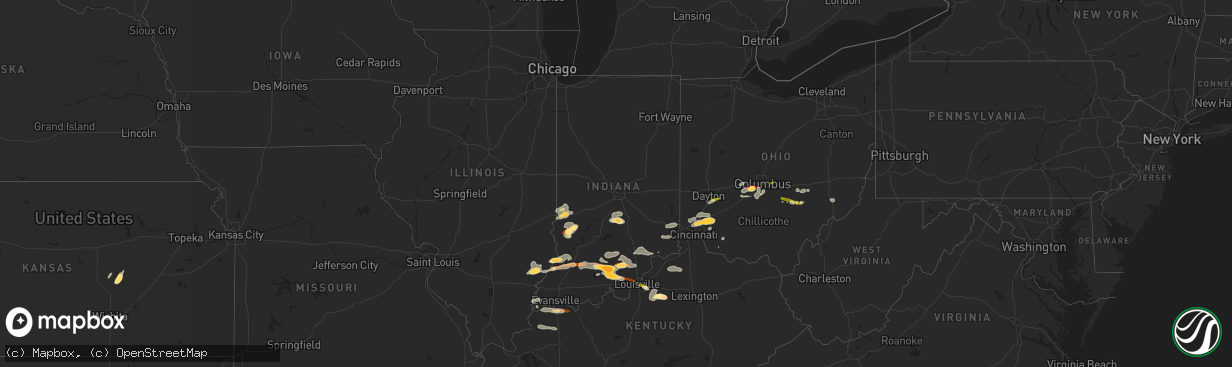
Hail Map in Indiana on April 16, 2013
The weather event in Indiana on April 16, 2013 includes Hail map. 6 states and 195 cities were impacted and suffered possible damage. The total estimated number of properties impacted is 20,796.
Want more than just the map?
Turn this storm into a full workflow.
- Owner + property data so you know who to knock
- OnDemand branded weather history reports to win the "did we even have hail?" argument
- RoofTrace estimate so reps stop guessing numbers at the door
Bought this map? Upgrade within 7 days and we'll credit the $230. (10-15 min setup call)
Hail
20,796
Estimated number of impacted properties by a 1.00" hail or larger12,130
Estimated number of impacted properties by a 1.75" hail or larger1,005
Estimated number of impacted properties by a 2.50" hail or largerStorm reports in Indiana
Indiana
| Date | Description |
|---|---|
| 04/16/20136:43 PM CDT | A local report indicates 1.00 inch wind near MARENGO |
| 04/16/20136:35 PM CDT | A local report indicates 1.75 inch wind near MARENGO |
| 04/16/20135:58 PM CDT | A local report indicates 1.00 inch wind near DECKER |
| 04/16/20135:24 PM CDT | A local report indicates 1.00 inch wind near SOUTH BOSTON |
| 04/16/20135:12 PM CDT | A local report indicates 1.75 inch wind near SALEM |
| 04/16/20134:26 PM CDT | Report from paoli high school |
| 04/16/20131:50 AM CDT | Hail covering the ground. |
| 04/15/20139:55 PM CDT | A local report indicates 1.75 inch wind near TERRE HAUTE |
| 04/15/20139:55 PM CDT | A local report indicates 1.75 inch wind near COALMONT |
| 04/15/20139:20 PM CDT | Ground nearly covered like snow |
| 04/15/20139:19 PM CDT | Currently falling at the emergency dispatch center in vincennes. |
| 04/15/20139:18 PM CDT | Currently falling in vincennes. |
| 04/15/20138:15 PM CDT | Facebook report of heavy rain and hail from nickel to quarter size as well as winds to 40-45 mph. |
| 04/15/20138:03 PM CDT | A local report indicates 2.75 inch wind near 5 SE PAOLI |
| 04/15/20138:00 PM CDT | A local report indicates 1.75 inch wind near PAOLI |
| 04/15/20137:58 PM CDT | A local report indicates 1.00 inch wind near PAOLI |
| 04/15/20137:52 PM CDT | A local report indicates 1.75 inch wind near PAOLI |
| 04/15/20137:49 PM CDT | A local report indicates 1.00 inch wind near 3 N MADISON |
| 04/15/20137:47 PM CDT | A local report indicates 1.00 inch wind near 3 N MADISON |
| 04/15/20137:40 PM CDT | Penny to quarter size hail falling on the south side of town. |
| 04/15/20137:35 PM CDT | A local report indicates 1.00 inch wind near ROLAND |
| 04/15/20137:26 PM CDT | A local report indicates 1.00 inch wind near ROLAND |
| 04/15/20137:24 PM CDT | A local report indicates 1.00 inch wind near FLOYDS KNOBS |
| 04/15/20137:23 PM CDT | Quarter size hail reported in the community. |
| 04/15/20137:20 PM CDT | Quarter size hail reported. |
Cities Impacted by Hail Map on April 16, 2013
- Salem, IN
- West Jefferson, OH
- London, OH
- Galloway, OH
- Grove City, OH
- Mount Eden, KY
- Taylorsville, KY
- Morrow, OH
- Loveland, OH
- Maineville, OH
- West Salem, IL
- Bone Gap, IL
- Shoals, IN
- West Baden Springs, IN
- New Salisbury, IN
- Milltown, IN
- Ramsey, IN
- Orleans, IN
- Marengo, IN
- English, IN
- Hardinsburg, IN
- Paoli, IN
- French Lick, IN
- Campbellsburg, IN
- Depauw, IN
- Mount Carmel, IL
- Albion, IL
- Mason, OH
- Marion, KS
- Hillsboro, KS
- Nineveh, IN
- Trafalgar, IN
- Nashville, IN
- Morgantown, IN
- Roseville, OH
- Zanesville, OH
- Philo, OH
- Fredericksburg, IN
- Underwood, IN
- Henryville, IN
- Loogootee, IN
- Scottsburg, IN
- Palmyra, IN
- Greenville, IN
- Montgomery, IN
- Cannelburg, IN
- Georgetown, IN
- Vallonia, IN
- Pekin, IN
- Dubois, IN
- Lancaster, OH
- Sugar Grove, OH
- Pleasant Plain, OH
- Cincinnati, OH
- Goshen, OH
- Orient, OH
- Commercial Point, OH
- Ashville, OH
- Lockbourne, OH
- Circleville, OH
- Robards, KY
- Corydon, KY
- Henderson, KY
- Uniontown, KY
- Waverly, KY
- Dennison, IL
- Rosedale, IN
- Riley, IN
- Paris, IL
- Brazil, IN
- West Terre Haute, IN
- Terre Haute, IN
- South Solon, OH
- Mount Sterling, OH
- Clay City, IN
- Sullivan, IN
- Jasonville, IN
- Shelburn, IN
- Louisville, KY
- Logan, OH
- Sturgis, KY
- Manitou, KY
- Clay, KY
- Dixon, KY
- Providence, KY
- Slaughters, KY
- Nebo, KY
- Hanson, KY
- South Lebanon, OH
- Blanchester, OH
- West Chester, OH
- Kings Mills, OH
- Vincennes, IN
- Hamilton, OH
- Fairfield, OH
- Bethel, OH
- Mount Orab, OH
- Sardinia, OH
- Carmi, IL
- Mount Vernon, IN
- New Haven, IL
- Washington, IN
- Monroe City, IN
- Lawrenceville, IL
- Bicknell, IN
- Wheatland, IN
- Ragsdale, IN
- Bruceville, IN
- Saint Francisville, IL
- Linton, IN
- Dugger, IN
- Perry Park, KY
- Owenton, KY
- Campbellsburg, KY
- Pleasureville, KY
- Lockport, KY
- Turners Station, KY
- Bethlehem, KY
- Peabody, KS
- Columbus, OH
- Coalmont, IN
- Decker, IN
- Versailles, IN
- Dillsboro, IN
- Moores Hill, IN
- Milan, IN
- Bloomfield, KY
- Coal City, IN
- Lewis, IN
- Columbus, IN
- New Lexington, OH
- Somerset, OH
- Golden Gate, IL
- Ellery, IL
- Petersburg, IN
- Parkersburg, IL
- Calhoun, IL
- Olney, IL
- Hazleton, IN
- Monroe, OH
- Middletown, OH
- Lebanon, OH
- Guilford, IN
- Brookville, IN
- Lawrenceburg, IN
- West Harrison, IN
- Sunman, IN
- Bellbrook, OH
- Dayton, OH
- Mitchell, IN
- Batavia, OH
- Milford, OH
- Hymera, IN
- Pimento, IN
- Farmersburg, IN
- Worthington, IN
- Crothersville, IN
- Commiskey, IN
- Madison, IN
- Austin, IN
- Lexington, IN
- Paris Crossing, IN
- Deputy, IN
- Eckerty, IN
- Taswell, IN
- Mount Perry, OH
- Rives, TN
- Union City, TN
- Bedford, IN
- Tunnelton, IN
- Medora, IN
- Lawrenceburg, KY
- Waddy, KY
- Shawnee, OH
- Corning, OH
- Martinsville, IN
- Bargersville, IN
- Franklin, IN
- New Straitsville, OH
- Fisherville, KY
- Shelbyville, KY
- Coxs Creek, KY
- Finchville, KY
- Simpsonville, KY
- Junction City, OH
- Bremen, OH
- Hamersville, OH
- Lehigh, KS
- Dexter City, OH
- Caldwell, OH
- New Albany, IN
- Owensboro, KY
- Floyds Knobs, IN
- Xenia, OH
- Reynoldsburg, OH


