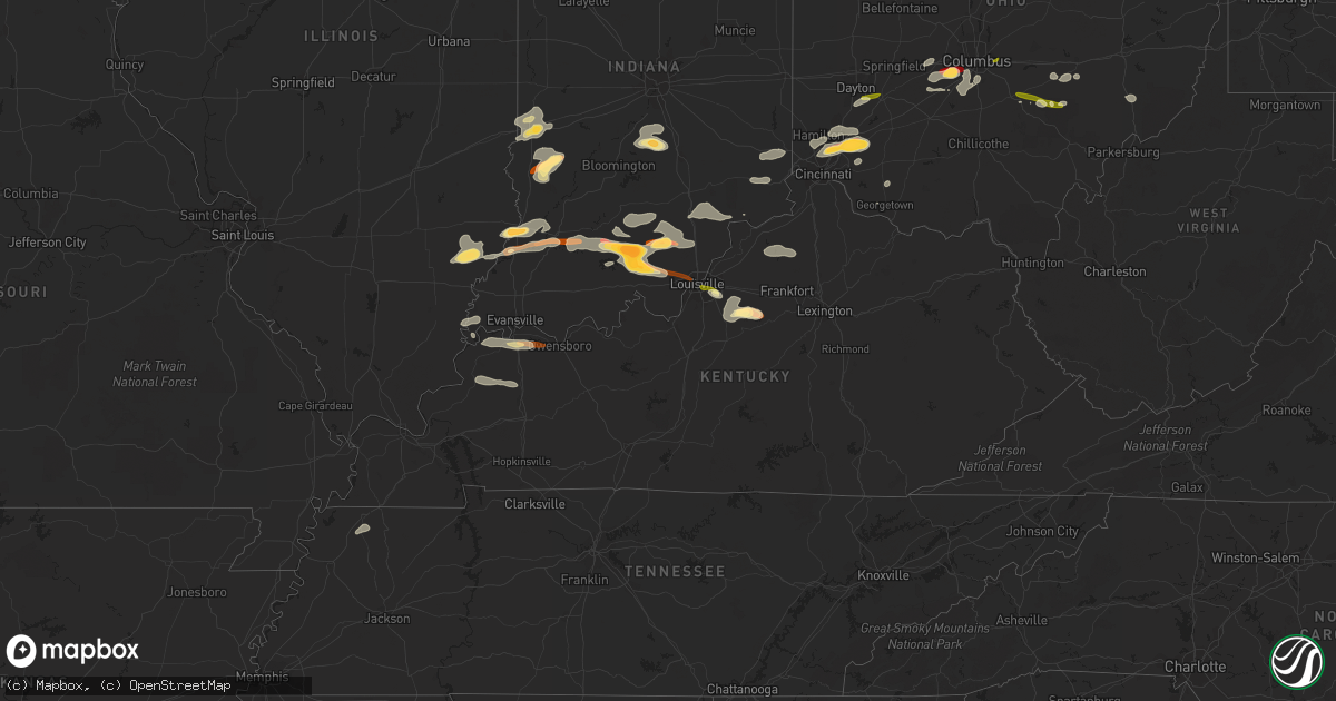
Hail Map in Kentucky on April 16, 2013
Get this storm
April 16 map
$229
one time, instant access
Download today. No call, no setup
Keep the $229
Bought the map and want the full workflow? Apply the entire $229 to a subscription within 7 days. None of it is wasted.
Every map, not just this one
This buys you this map. Subscription and you get every map we run, in the markets you choose from a few cities to whole states to nationwide. Plus real-time alerts the moment a storm fires.
Contact data
Name, contact info, occupancy, even credit band for addresses in the footprint. You go from where it hit to who to call.
Become the source they trust
Unlimited branding weather history reports on demand. You already have the documented answer ready for the property owner, and you are the one who showed up with it.
Property data and RoofTrace estimates
Pull up any address you have got, its value and the exact code rules for that jurisdiction, straight from One Click Code. Then RoofTrace estimates the squares, pitch, and roof value, priced the way you price.
Storm reports in Kentucky
Kentucky
| Date | Description |
|---|---|
| 04/16/20136:25 PM CDT | Via social media. Time estimated from radar. |
| 04/16/20135:33 PM CDT | Quarter size hail reported 8 miles east of henderson on the audubon parkway. |
| 04/16/20135:29 PM CDT | Dime and quarter size hail falling in the community. |
| 04/16/20135:17 PM CDT | Quarter size hail reported by em. |
| 04/16/201312:37 AM CDT | Roof damage to an administration building of a camp. |
| 04/15/20139:09 PM CDT | Quarter size hail reported in the downtown area. |
| 04/15/20138:50 PM CDT | Multiple trees down along rt. 5 in ashland... Ky |
| 04/15/20138:27 PM CDT | Covering the ground |
| 04/15/20138:20 PM CDT | A local report indicates 1.75 inch wind near TAYLORSVILLE |
| 04/15/20138:05 PM CDT | A local report indicates 1.00 inch wind near FERN CREEK |
| 04/15/20138:03 PM CDT | A local report indicates 1.25 inch wind near JEFFERSONTOWN |
| 04/15/20138:02 PM CDT | Quarter size hail was covering a deck |
| 04/15/20137:55 PM CDT | At bowman field |
| 04/15/20137:50 PM CDT | A local report indicates 1.00 inch wind near LOUISVILLE |
| 04/15/20137:18 PM CDT | Multiple trees down along rt. 5 in ashland... Ky |
Cities Impacted by Hail Map on April 16, 2013
- Salem, IN
- West Jefferson, OH
- London, OH
- Galloway, OH
- Grove City, OH
- Mount Eden, KY
- Taylorsville, KY
- Morrow, OH
- Loveland, OH
- Maineville, OH
- West Salem, IL
- Bone Gap, IL
- Shoals, IN
- West Baden Springs, IN
- New Salisbury, IN
- Milltown, IN
- Ramsey, IN
- Orleans, IN
- Marengo, IN
- English, IN
- Hardinsburg, IN
- Paoli, IN
- French Lick, IN
- Campbellsburg, IN
- Depauw, IN
- Mount Carmel, IL
- Albion, IL
- Mason, OH
- Marion, KS
- Hillsboro, KS
- Nineveh, IN
- Trafalgar, IN
- Nashville, IN
- Morgantown, IN
- Roseville, OH
- Zanesville, OH
- Philo, OH
- Fredericksburg, IN
- Underwood, IN
- Henryville, IN
- Loogootee, IN
- Scottsburg, IN
- Palmyra, IN
- Greenville, IN
- Montgomery, IN
- Cannelburg, IN
- Georgetown, IN
- Vallonia, IN
- Pekin, IN
- Dubois, IN
- Lancaster, OH
- Sugar Grove, OH
- Pleasant Plain, OH
- Cincinnati, OH
- Goshen, OH
- Orient, OH
- Commercial Point, OH
- Ashville, OH
- Lockbourne, OH
- Circleville, OH
- Robards, KY
- Corydon, KY
- Henderson, KY
- Uniontown, KY
- Waverly, KY
- Dennison, IL
- Rosedale, IN
- Riley, IN
- Paris, IL
- Brazil, IN
- West Terre Haute, IN
- Terre Haute, IN
- South Solon, OH
- Mount Sterling, OH
- Clay City, IN
- Sullivan, IN
- Jasonville, IN
- Shelburn, IN
- Louisville, KY
- Logan, OH
- Sturgis, KY
- Manitou, KY
- Clay, KY
- Dixon, KY
- Providence, KY
- Slaughters, KY
- Nebo, KY
- Hanson, KY
- South Lebanon, OH
- Blanchester, OH
- West Chester, OH
- Kings Mills, OH
- Vincennes, IN
- Hamilton, OH
- Fairfield, OH
- Bethel, OH
- Mount Orab, OH
- Sardinia, OH
- Carmi, IL
- Mount Vernon, IN
- New Haven, IL
- Washington, IN
- Monroe City, IN
- Lawrenceville, IL
- Bicknell, IN
- Wheatland, IN
- Ragsdale, IN
- Bruceville, IN
- Saint Francisville, IL
- Linton, IN
- Dugger, IN
- Perry Park, KY
- Owenton, KY
- Campbellsburg, KY
- Pleasureville, KY
- Lockport, KY
- Turners Station, KY
- Bethlehem, KY
- Peabody, KS
- Columbus, OH
- Coalmont, IN
- Decker, IN
- Versailles, IN
- Dillsboro, IN
- Moores Hill, IN
- Milan, IN
- Bloomfield, KY
- Coal City, IN
- Lewis, IN
- Columbus, IN
- New Lexington, OH
- Somerset, OH
- Golden Gate, IL
- Ellery, IL
- Petersburg, IN
- Parkersburg, IL
- Calhoun, IL
- Olney, IL
- Hazleton, IN
- Monroe, OH
- Middletown, OH
- Lebanon, OH
- Guilford, IN
- Brookville, IN
- Lawrenceburg, IN
- West Harrison, IN
- Sunman, IN
- Bellbrook, OH
- Dayton, OH
- Mitchell, IN
- Batavia, OH
- Milford, OH
- Hymera, IN
- Pimento, IN
- Farmersburg, IN
- Worthington, IN
- Crothersville, IN
- Commiskey, IN
- Madison, IN
- Austin, IN
- Lexington, IN
- Paris Crossing, IN
- Deputy, IN
- Eckerty, IN
- Taswell, IN
- Mount Perry, OH
- Rives, TN
- Union City, TN
- Bedford, IN
- Tunnelton, IN
- Medora, IN
- Lawrenceburg, KY
- Waddy, KY
- Shawnee, OH
- Corning, OH
- Martinsville, IN
- Bargersville, IN
- Franklin, IN
- New Straitsville, OH
- Fisherville, KY
- Shelbyville, KY
- Coxs Creek, KY
- Finchville, KY
- Simpsonville, KY
- Junction City, OH
- Bremen, OH
- Hamersville, OH
- Lehigh, KS
- Dexter City, OH
- Caldwell, OH
- New Albany, IN
- Owensboro, KY
- Floyds Knobs, IN
- Xenia, OH
- Reynoldsburg, OH


