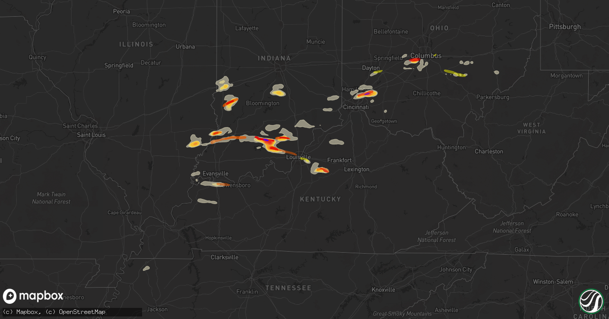
Hail Map on April 16, 2013
Get this storm
April 16 map
$229
one time, instant access
Download today. No call, no setup
Keep the $229
Bought the map and want the full workflow? Apply the entire $229 to a subscription within 7 days. None of it is wasted.
Every map, not just this one
This buys you this map. Subscription and you get every map we run, in the markets you choose from a few cities to whole states to nationwide. Plus real-time alerts the moment a storm fires.
Contact data
Name, contact info, occupancy, even credit band for addresses in the footprint. You go from where it hit to who to call.
Become the source they trust
Unlimited branding weather history reports on demand. You already have the documented answer ready for the property owner, and you are the one who showed up with it.
Property data and RoofTrace estimates
Pull up any address you have got, its value and the exact code rules for that jurisdiction, straight from One Click Code. Then RoofTrace estimates the squares, pitch, and roof value, priced the way you price.
Storm reports
Pennsylvania
| Date | Description |
|---|---|
| 04/16/20136:49 PM CDT | Trees and wires down |
| 04/16/20136:45 PM CDT | A local report indicates 1.00 inch wind near ROBINSON TOWNSHIP |
| 04/16/20136:30 PM CDT | Trees blown down in economy |
| 04/16/20136:18 PM CDT | Tree down |
| 04/16/20136:05 PM CDT | Trees blown down in new sewickely township east of monaca |
| 04/15/20138:00 PM CDT | Trees blown down on route 30 and chestnut ridge road near sleepy hollow |
| 04/15/20137:25 PM CDT | Picture of large limbs down |
| 04/15/20137:09 PM CDT | Trees down |
Illinois
| Date | Description |
|---|---|
| 04/15/20139:00 PM CDT | Late report. Golf ball size hail reported north of town. |
| 04/15/20138:40 PM CDT | Delayed report. Size ranged from 1/4 to 1 inch. Hail lasted 10 mins. |
Kansas
| Date | Description |
|---|---|
| 04/16/20133:48 AM CDT | Hail ranged from golfball to hen egg size. |
| 04/16/20131:05 AM CDT | A local report indicates 1.00 inch wind near 5 WSW HAVILAND |
| 04/16/201312:29 AM CDT | A local report indicates 1.00 inch wind near COLDWATER |
Kentucky
| Date | Description |
|---|---|
| 04/16/20136:25 PM CDT | Via social media. Time estimated from radar. |
| 04/16/20135:33 PM CDT | Quarter size hail reported 8 miles east of henderson on the audubon parkway. |
| 04/16/20135:29 PM CDT | Dime and quarter size hail falling in the community. |
| 04/16/20135:17 PM CDT | Quarter size hail reported by em. |
| 04/16/201312:37 AM CDT | Roof damage to an administration building of a camp. |
| 04/15/20139:09 PM CDT | Quarter size hail reported in the downtown area. |
| 04/15/20138:50 PM CDT | Multiple trees down along rt. 5 in ashland... Ky |
| 04/15/20138:27 PM CDT | Covering the ground |
| 04/15/20138:20 PM CDT | A local report indicates 1.75 inch wind near TAYLORSVILLE |
| 04/15/20138:05 PM CDT | A local report indicates 1.00 inch wind near FERN CREEK |
| 04/15/20138:03 PM CDT | A local report indicates 1.25 inch wind near JEFFERSONTOWN |
| 04/15/20138:02 PM CDT | Quarter size hail was covering a deck |
| 04/15/20137:55 PM CDT | At bowman field |
| 04/15/20137:50 PM CDT | A local report indicates 1.00 inch wind near LOUISVILLE |
| 04/15/20137:18 PM CDT | Multiple trees down along rt. 5 in ashland... Ky |
Indiana
| Date | Description |
|---|---|
| 04/16/20136:43 PM CDT | A local report indicates 1.00 inch wind near MARENGO |
| 04/16/20136:35 PM CDT | A local report indicates 1.75 inch wind near MARENGO |
| 04/16/20135:58 PM CDT | A local report indicates 1.00 inch wind near DECKER |
| 04/16/20135:24 PM CDT | A local report indicates 1.00 inch wind near SOUTH BOSTON |
| 04/16/20135:12 PM CDT | A local report indicates 1.75 inch wind near SALEM |
| 04/16/20134:26 PM CDT | Report from paoli high school |
| 04/16/20131:50 AM CDT | Hail covering the ground. |
| 04/15/20139:55 PM CDT | A local report indicates 1.75 inch wind near TERRE HAUTE |
| 04/15/20139:55 PM CDT | A local report indicates 1.75 inch wind near COALMONT |
| 04/15/20139:20 PM CDT | Ground nearly covered like snow |
| 04/15/20139:19 PM CDT | Currently falling at the emergency dispatch center in vincennes. |
| 04/15/20139:18 PM CDT | Currently falling in vincennes. |
| 04/15/20138:15 PM CDT | Facebook report of heavy rain and hail from nickel to quarter size as well as winds to 40-45 mph. |
| 04/15/20138:03 PM CDT | A local report indicates 2.75 inch wind near 5 SE PAOLI |
| 04/15/20138:00 PM CDT | A local report indicates 1.75 inch wind near PAOLI |
| 04/15/20137:58 PM CDT | A local report indicates 1.00 inch wind near PAOLI |
| 04/15/20137:52 PM CDT | A local report indicates 1.75 inch wind near PAOLI |
| 04/15/20137:49 PM CDT | A local report indicates 1.00 inch wind near 3 N MADISON |
| 04/15/20137:47 PM CDT | A local report indicates 1.00 inch wind near 3 N MADISON |
| 04/15/20137:40 PM CDT | Penny to quarter size hail falling on the south side of town. |
| 04/15/20137:35 PM CDT | A local report indicates 1.00 inch wind near ROLAND |
| 04/15/20137:26 PM CDT | A local report indicates 1.00 inch wind near ROLAND |
| 04/15/20137:24 PM CDT | A local report indicates 1.00 inch wind near FLOYDS KNOBS |
| 04/15/20137:23 PM CDT | Quarter size hail reported in the community. |
| 04/15/20137:20 PM CDT | Quarter size hail reported. |
Missouri
| Date | Description |
|---|---|
| 04/16/20137:43 AM CDT | A local report indicates 1.00 inch wind near 2 N PUMPKIN CENTER |
Ohio
| Date | Description |
|---|---|
| 04/16/20136:29 PM CDT | A local report indicates 1.00 inch wind near SHAWNEE |
| 04/16/20135:55 PM CDT | One tree down on power line in newton township |
| 04/16/20135:53 PM CDT | A local report indicates 1.00 inch wind near LANCASTER |
| 04/16/20135:35 PM CDT | Heavy wooden playset tipped over |
| 04/16/20135:23 PM CDT | A local report indicates 1.00 inch wind near 1 NNW SOUTH OLIVE |
| 04/16/20135:01 PM CDT | Anderson township area. Power poles blown down. |
| 04/16/20134:38 PM CDT | Relayed by state ema |
| 04/16/20134:32 PM CDT | A local report indicates 1.00 inch wind near 1 NW MAINEVILLE |
| 04/16/20134:30 PM CDT | A local report indicates 1.25 inch wind near MAINEVILLE |
| 04/16/20134:29 PM CDT | Hail duration 3 minutes. |
| 04/16/20134:29 PM CDT | A local report indicates 2.00 inch wind near MAINEVILLE |
| 04/16/20134:28 PM CDT | A local report indicates 1.00 inch wind near KINGS MILLS |
| 04/16/20134:24 PM CDT | A local report indicates 1.00 inch wind near 3 N LOVELAND |
| 04/16/20134:21 PM CDT | A local report indicates 1.00 inch wind near MASON |
| 04/16/20134:21 PM CDT | A local report indicates 1.25 inch wind near MAINEVILLE |
| 04/16/20134:15 PM CDT | A local report indicates 1.00 inch wind near 6 NE BLUE ASH |
| 04/16/20134:10 PM CDT | A local report indicates 1.25 inch wind near 5 N BLUE ASH |
| 04/16/20134:09 PM CDT | A local report indicates 1.50 inch wind near S WEST JEFFERSON |
| 04/16/20134:09 PM CDT | A local report indicates 1.75 inch wind near 3 S WEST JEFFERSON |
| 04/16/20134:06 PM CDT | A local report indicates 1.50 inch wind near SHARONVILLE |
| 04/16/20133:54 PM CDT | A local report indicates 1.00 inch wind near XENIA |
| 04/16/20133:43 PM CDT | A local report indicates 1.00 inch wind near 2 S BEAVERCREEK |
| 04/15/20137:46 PM CDT | Trees blown down ozark eddy bridge road |
West Virginia
| Date | Description |
|---|---|
| 04/15/20138:26 PM CDT | A local report indicates 61 MPH wind near 3 NE CHARLESTON |
| 04/15/20138:22 PM CDT | A local report indicates 61 MPH wind near 3 NE CHARLESTON |
| 04/15/20137:40 PM CDT | Tree blown down on route 7 blocking lane 7 miles out of new martinsville wv |
Cities Impacted by Hail Map on April 16, 2013
- Salem, IN
- West Jefferson, OH
- London, OH
- Galloway, OH
- Grove City, OH
- Mount Eden, KY
- Taylorsville, KY
- Morrow, OH
- Loveland, OH
- Maineville, OH
- West Salem, IL
- Bone Gap, IL
- Shoals, IN
- West Baden Springs, IN
- New Salisbury, IN
- Milltown, IN
- Ramsey, IN
- Orleans, IN
- Marengo, IN
- English, IN
- Hardinsburg, IN
- Paoli, IN
- French Lick, IN
- Campbellsburg, IN
- Depauw, IN
- Mount Carmel, IL
- Albion, IL
- Mason, OH
- Marion, KS
- Hillsboro, KS
- Nineveh, IN
- Trafalgar, IN
- Nashville, IN
- Morgantown, IN
- Roseville, OH
- Zanesville, OH
- Philo, OH
- Fredericksburg, IN
- Underwood, IN
- Henryville, IN
- Loogootee, IN
- Scottsburg, IN
- Palmyra, IN
- Greenville, IN
- Montgomery, IN
- Cannelburg, IN
- Georgetown, IN
- Vallonia, IN
- Pekin, IN
- Dubois, IN
- Lancaster, OH
- Sugar Grove, OH
- Pleasant Plain, OH
- Cincinnati, OH
- Goshen, OH
- Orient, OH
- Commercial Point, OH
- Ashville, OH
- Lockbourne, OH
- Circleville, OH
- Robards, KY
- Corydon, KY
- Henderson, KY
- Uniontown, KY
- Waverly, KY
- Dennison, IL
- Rosedale, IN
- Riley, IN
- Paris, IL
- Brazil, IN
- West Terre Haute, IN
- Terre Haute, IN
- South Solon, OH
- Mount Sterling, OH
- Clay City, IN
- Sullivan, IN
- Jasonville, IN
- Shelburn, IN
- Louisville, KY
- Logan, OH
- Sturgis, KY
- Manitou, KY
- Clay, KY
- Dixon, KY
- Providence, KY
- Slaughters, KY
- Nebo, KY
- Hanson, KY
- South Lebanon, OH
- Blanchester, OH
- West Chester, OH
- Kings Mills, OH
- Vincennes, IN
- Hamilton, OH
- Fairfield, OH
- Bethel, OH
- Mount Orab, OH
- Sardinia, OH
- Carmi, IL
- Mount Vernon, IN
- New Haven, IL
- Washington, IN
- Monroe City, IN
- Lawrenceville, IL
- Bicknell, IN
- Wheatland, IN
- Ragsdale, IN
- Bruceville, IN
- Saint Francisville, IL
- Linton, IN
- Dugger, IN
- Perry Park, KY
- Owenton, KY
- Campbellsburg, KY
- Pleasureville, KY
- Lockport, KY
- Turners Station, KY
- Bethlehem, KY
- Peabody, KS
- Columbus, OH
- Coalmont, IN
- Decker, IN
- Versailles, IN
- Dillsboro, IN
- Moores Hill, IN
- Milan, IN
- Bloomfield, KY
- Coal City, IN
- Lewis, IN
- Columbus, IN
- New Lexington, OH
- Somerset, OH
- Golden Gate, IL
- Ellery, IL
- Petersburg, IN
- Parkersburg, IL
- Calhoun, IL
- Olney, IL
- Hazleton, IN
- Monroe, OH
- Middletown, OH
- Lebanon, OH
- Guilford, IN
- Brookville, IN
- Lawrenceburg, IN
- West Harrison, IN
- Sunman, IN
- Bellbrook, OH
- Dayton, OH
- Mitchell, IN
- Batavia, OH
- Milford, OH
- Hymera, IN
- Pimento, IN
- Farmersburg, IN
- Worthington, IN
- Crothersville, IN
- Commiskey, IN
- Madison, IN
- Austin, IN
- Lexington, IN
- Paris Crossing, IN
- Deputy, IN
- Eckerty, IN
- Taswell, IN
- Mount Perry, OH
- Rives, TN
- Union City, TN
- Bedford, IN
- Tunnelton, IN
- Medora, IN
- Lawrenceburg, KY
- Waddy, KY
- Shawnee, OH
- Corning, OH
- Martinsville, IN
- Bargersville, IN
- Franklin, IN
- New Straitsville, OH
- Fisherville, KY
- Shelbyville, KY
- Coxs Creek, KY
- Finchville, KY
- Simpsonville, KY
- Junction City, OH
- Bremen, OH
- Hamersville, OH
- Lehigh, KS
- Dexter City, OH
- Caldwell, OH
- New Albany, IN
- Owensboro, KY
- Floyds Knobs, IN
- Xenia, OH
- Reynoldsburg, OH