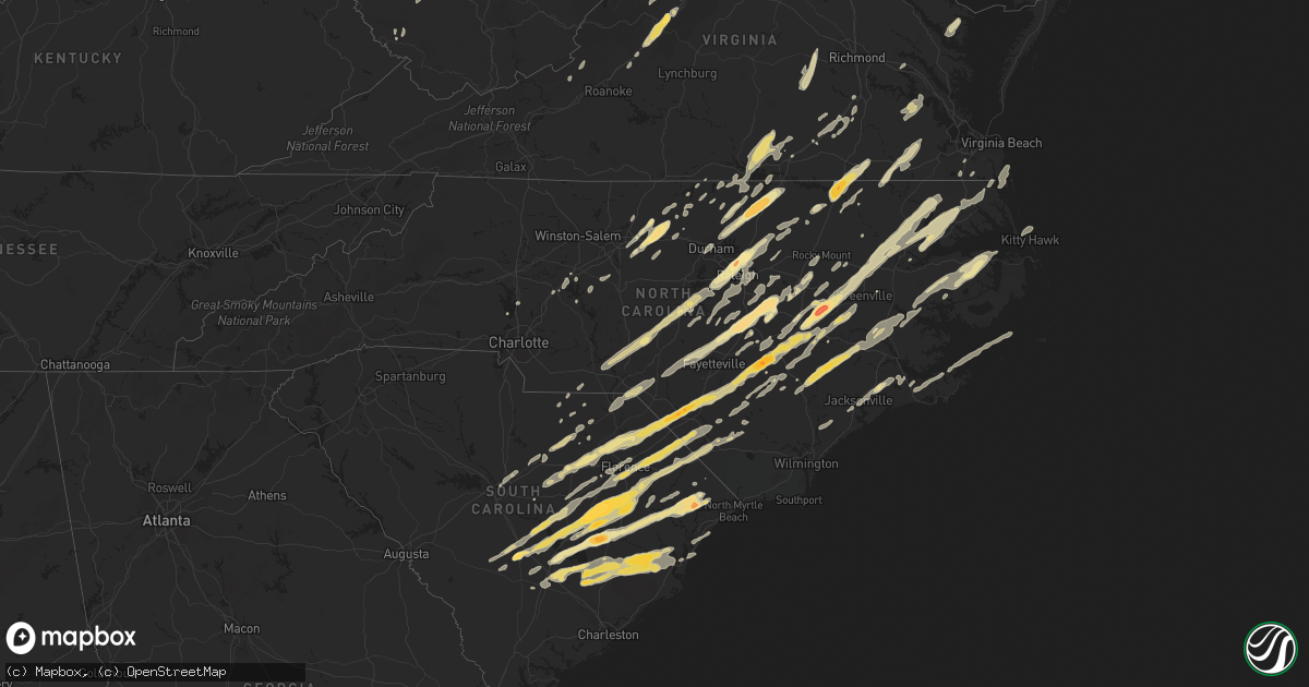
Hail Map in South Carolina on April 16, 2011
Get this storm
April 16 map
$229
one time, instant access
Download today. No call, no setup
Keep the $229
Bought the map and want the full workflow? Apply the entire $229 to a subscription within 7 days. None of it is wasted.
Every map, not just this one
This buys you this map. Subscription and you get every map we run, in the markets you choose from a few cities to whole states to nationwide. Plus real-time alerts the moment a storm fires.
Contact data
Name, contact info, occupancy, even credit band for addresses in the footprint. You go from where it hit to who to call.
Become the source they trust
Unlimited branding weather history reports on demand. You already have the documented answer ready for the property owner, and you are the one who showed up with it.
Property data and RoofTrace estimates
Pull up any address you have got, its value and the exact code rules for that jurisdiction, straight from One Click Code. Then RoofTrace estimates the squares, pitch, and roof value, priced the way you price.
Storm reports in South Carolina
South Carolina
| Date | Description |
|---|---|
| 04/16/20115:29 PM CDT | Many trees down. Indian hut road at tallowtree drive. |
| 04/16/20115:04 PM CDT | Tree down in intersection of hwy 65 long ave ext. |
| 04/16/20115:04 PM CDT | Tree in the roadway at the intersection of hwy 17a and sc 41. |
| 04/16/20114:57 PM CDT | A local report indicates 1.00 inch wind near 8 WNW JAMESTOWN |
| 04/16/20114:52 PM CDT | Trees down. Small hail was also reported. |
| 04/16/20114:45 PM CDT | Boats thrown onto a yard. Numerous trees down. 13529 saints delight road. |
| 04/16/20114:43 PM CDT | Off duty fire fighter reports golf ball size hall near andrews. |
| 04/16/20114:37 PM CDT | A local report indicates 1.25 inch wind near 6 SE AYNOR |
| 04/16/20114:32 PM CDT | A local report indicates 1.75 inch wind near 2 SW CONWAY |
| 04/16/20114:24 PM CDT | Tree and power line down. |
| 04/16/20114:21 PM CDT | Tornado on ground...reported via law enforcement. Reported near intersection of s main st and hood st in saint stephen. |
| 04/16/20114:20 PM CDT | Trained spotter reported at least 100 trees down near saint stephen. Trees were 12 to 18 inches in diameter. Shingle damage also seen on 1 home. |
| 04/16/20114:20 PM CDT | Tornado sighted along 2000 block of mendel rivers road. |
| 04/16/20114:16 PM CDT | A fire department official reported a fully collapsed church. 6 people were inside but no injuries were reported. Church located between saint stephen south carolina an |
| 04/16/20114:16 PM CDT | Nws damage survey team has confirmed a tornado moved very near saint stephen south carolina. The tornado destroyed a church. Six people were inside...none were injured. |
| 04/16/20114:16 PM CDT | A fire department official reported a tornado touched down ripping the roof off a building along with knocking numerous power lines down just outside of saint stephen s |
| 04/16/20114:09 PM CDT | The public reported quarter size hail in bonneau beach south carolina. |
| 04/16/20114:03 PM CDT | Ef-1 tornado confirmed. Tornadic waterspout formed over n. Lake moultrie at 503 pm and traveled e ne 2 miles before coming onshore 2.5 miles sw of russellville. Tornado |
| 04/16/20114:00 PM CDT | Powerline down. Dumbar road at black river bridge. |
| 04/16/20113:53 PM CDT | Golfball sized hail reported near tree farm lane and hwy 311. |
| 04/16/20113:48 PM CDT | Trees down on hwy 521 near salters. |
| 04/16/20113:33 PM CDT | Quarter size hail reported along with heavy rain. |
| 04/16/20113:26 PM CDT | A local report indicates 1.75 inch wind near GREELEYVILLE |
| 04/16/20113:25 PM CDT | At least five trees on homes. Three people were admitted to the hospital and were released. |
| 04/16/20113:13 PM CDT | Santee cooper dam operators at lake marion reported a tornado was sighted over the lake then touched down below the dam on the clarendon county side uprooting trees and |
| 04/16/20112:50 PM CDT | Golfball size hail on trifalia and mccalister roads at camp branch. |
| 04/16/20112:48 PM CDT | Trees down on cedar swamp rd... One mile from sc 527. |
| 04/16/20112:38 PM CDT | Softball size hail reported at fire station 2. Time estimated from radar. |
| 04/16/20112:35 PM CDT | Golf ball sized hail reported by sheriff in turbeville. |
| 04/16/20112:28 PM CDT | Softball size hail at hwy 301 and north brewington road causing damage to roofs and vehicles. |
| 04/16/20112:27 PM CDT | A nws storm survey found and ef0 tornado in eastern clarendon county. The path consisted of intermittent touchdowns that was a length of 9 miles. The width ranged from |
| 04/16/20112:25 PM CDT | At least five trees on homes. Three people were admitted to the hospital and were released. |
| 04/16/20112:25 PM CDT | Trees and power lines down. |
| 04/16/20112:17 PM CDT | Trees down on governor richards rd in rimini reported by sheriff. |
| 04/16/20112:05 PM CDT | Power lines down and outages in and around summerton. |
| 04/16/20112:00 PM CDT | 1 inch hail reported by sheriff on furse rd. |
| 04/16/20111:46 PM CDT | Trees down on mt clair rd... Jeffords mill rd... Indian branch rd... And silvia ln. |
| 04/16/20111:30 PM CDT | Golf ball size hail reported at fire station 4 at rowesville road and prosperity drive. Reported by sheriff. |
| 04/16/20111:17 PM CDT | Sheriff reports power lines down and traffic lights out near bishopville. |
| 04/16/20111:10 PM CDT | Quarter size hail reported by public. |
| 04/16/20111:00 PM CDT | Black river power reported power lines down and outages in sumter county. |
| 04/16/201112:52 PM CDT | Power lines down in camden. |
| 04/16/201112:20 PM CDT | Quarter size hail along with trees and power lines down at the village at sandhills. |
| 04/16/201112:20 PM CDT | Trees down and on power lines at hwy 76 and hiller road. |
All States Impacted by Hail Map on April 16, 2011
Cities Impacted by Hail Map on April 16, 2011
- Efland, NC
- Deep Run, NC
- Kenansville, NC
- Kinston, NC
- Beulaville, NC
- Rose Hill, NC
- Pink Hill, NC
- Dover, NC
- Magnolia, NC
- Trenton, NC
- Roanoke Rapids, NC
- Gaston, NC
- Emporia, VA
- Pleasant Hill, NC
- Garysburg, NC
- Skippers, VA
- Drewryville, VA
- Weldon, NC
- Boykins, VA
- Newsoms, VA
- Lillington, NC
- Reevesville, SC
- Branchville, SC
- Littleton, NC
- Enfield, NC
- New Zion, SC
- Gable, SC
- Andrews, SC
- Lane, SC
- Loris, SC
- Galivants Ferry, SC
- Maysville, NC
- Jacksonville, NC
- New Bern, NC
- Quantico, VA
- Stafford, VA
- Fair Bluff, NC
- Cerro Gordo, NC
- Orangeburg, SC
- Cordova, SC
- Columbia, NC
- Oxford, NC
- Stem, NC
- Burlington, NC
- Julian, NC
- Elon, NC
- Haw River, NC
- Whitsett, NC
- Henderson, NC
- Mebane, NC
- South Hill, VA
- Chase City, VA
- Lunenburg, VA
- Kenbridge, VA
- Boydton, VA
- Baskerville, VA
- Clarksville, VA
- Victoria, VA
- Skipwith, VA
- Conway, SC
- Aynor, SC
- Pawleys Island, SC
- Middleburg, NC
- Norlina, NC
- Creedmoor, NC
- Manson, NC
- Faison, NC
- Dudley, NC
- Mount Olive, NC
- Beaufort, NC
- Rowland, NC
- Summerton, SC
- Lake City, SC
- Olanta, SC
- Coward, SC
- Chadbourn, NC
- Pamplico, SC
- Alcolu, SC
- Elloree, SC
- Pinewood, SC
- Turbeville, SC
- Effingham, SC
- Nichols, SC
- Scranton, SC
- Santee, SC
- Manning, SC
- Greeleyville, SC
- Cades, SC
- Cameron, SC
- Mullins, SC
- Marion, SC
- Kingstree, SC
- Lancaster, VA
- Heathsville, VA
- Franklin, WV
- Merry Hill, NC
- Hertford, NC
- Edenton, NC
- Colerain, NC
- Belvidere, NC
- Windsor, NC
- Tyner, NC
- Steeles Tavern, VA
- Greenville, VA
- Staunton, VA
- Salters, SC
- Clinton, NC
- Vanceboro, NC
- Triangle, VA
- Fredericksburg, VA
- Fork, SC
- Sellers, SC
- Neeses, SC
- Timmonsville, SC
- Latta, SC
- Lynchburg, SC
- Sumter, SC
- Dillon, SC
- Cope, SC
- Lake View, SC
- Saint Matthews, SC
- Orrum, NC
- Lumberton, NC
- Fairmont, NC
- Norway, SC
- Florence, SC
- Mayesville, SC
- Hamer, SC
- Snow Hill, NC
- Pikeville, NC
- Goldsboro, NC
- Stantonsburg, NC
- Walstonburg, NC
- La Grange, NC
- Elkview, WV
- Charleston, WV
- Taneytown, MD
- Hanover, PA
- Littlestown, PA
- Jackson Springs, NC
- West End, NC
- Natural Bridge, VA
- Vesuvius, VA
- Buena Vista, VA
- Fairfield, VA
- Raphine, VA
- Glasgow, VA
- Lexington, VA
- Buchanan, VA
- Natural Bridge Station, VA
- Cary, NC
- Apex, NC
- Raleigh, NC
- Wake Forest, NC
- Autryville, NC
- Fayetteville, NC
- Salemburg, NC
- White Oak, NC
- Roseboro, NC
- Farmville, NC
- Fremont, NC
- Columbia, SC
- Millboro, VA
- New Castle, VA
- Prospect Hill, NC
- Hurdle Mills, NC
- Little Rock, SC
- Harleyville, SC
- Holly Hill, SC
- Elgin, SC
- Aulander, NC
- Robersonville, NC
- Hobbsville, NC
- Tarboro, NC
- Fountain, NC
- Williamston, NC
- Harrellsville, NC
- Oak City, NC
- Lewiston Woodville, NC
- Cofield, NC
- Bethel, NC
- Gatesville, NC
- Greenville, NC
- Ahoskie, NC
- Hamilton, NC
- Westminster, MD
- Bishopville, SC
- Elm City, NC
- Wilson, NC
- Gibsonville, NC
- Greensboro, NC
- Graham, NC
- McLeansville, NC
- Climax, NC
- Fort Bragg, NC
- Lucama, NC
- Saint Stephen, SC
- Bonneau, SC
- Cross, SC
- Pinopolis, SC
- Ernul, NC
- Chocowinity, NC
- Cove City, NC
- Grifton, NC
- Blounts Creek, NC
- Foster, WV
- Ridgeview, WV
- Ashford, WV
- Julian, WV
- Costa, WV
- Nellis, WV
- Peytona, WV
- Lexington, NC
- Salisbury, NC
- Seven Springs, NC
- Laurel Hill, NC
- Bennettsville, SC
- Hamlet, NC
- Bethune, SC
- Kershaw, SC
- Jefferson, SC
- Whiteville, NC
- Evergreen, NC
- Clarkton, NC
- Goshen, VA
- Craigsville, VA
- Haymarket, VA
- Broad Run, VA
- Reidsville, NC
- Browns Summit, NC
- Kenly, NC
- Roxboro, NC
- Chesterfield, SC
- Ruby, SC
- Powhatan, VA
- Amelia Court House, VA
- Carson, VA
- Crozier, VA
- Madison, WV
- Danville, WV
- Alum Creek, WV
- Belle, WV
- Racine, WV
- Hernshaw, WV
- Selma, NC
- Coats, NC
- Erwin, NC
- Clayton, NC
- Benson, NC
- Smithfield, NC
- Four Oaks, NC
- Dunn, NC
- Catawba, VA
- Havelock, NC
- Rowesville, SC
- Bowman, SC
- Jefferson, MD
- Richfield, NC
- Harrells, NC
- Garland, NC
- Eutawville, SC
- Vance, SC
- Delbarton, WV
- Alton, VA
- Lamar, SC
- Tar Heel, NC
- Maxton, NC
- Saint Pauls, NC
- Darlington, SC
- Dalzell, SC
- Shannon, NC
- Hartsville, SC
- Society Hill, SC
- Clio, SC
- Blenheim, SC
- Rembert, SC
- Pembroke, NC
- Red Springs, NC
- Omar, WV
- Summerville, SC
- Moncks Corner, SC
- Saint George, SC
- Georgetown, SC
- Jamestown, SC
- Pineville, SC
- Leesburg, VA
- Zuni, VA
- Carrsville, VA
- Franklin, VA
- Nesmith, SC
- Hemingway, SC
- Johnsonville, SC
- Gresham, SC
- Wallace, SC
- Petersburg, WV
- Monterey, VA
- Petersburg, VA
- Pine Level, NC
- Linden, NC
- Bluemont, VA
- West Point, VA
- Remington, VA
- Midland, VA
- Warrenton, VA
- Bealeton, VA
- Jeffersonton, VA
- Halifax, NC
- Capron, VA
- Branchville, VA
- Camden, SC
- Cassatt, SC
- Kittrell, NC
- Butner, NC
- Wendell, NC
- Williamsburg, VA
- Surry, VA
- Dendron, VA
- Elberon, VA
- Spring Grove, VA
- Waverly, VA
- Broadway, NC
- Sanford, NC
- Murrells Inlet, SC
- Myrtle Beach, SC
- Willow Spring, NC
- Fuquay Varina, NC
- Dickerson, MD
- Adamstown, MD
- Belhaven, NC
- Godwin, NC
- Catlett, VA
- Nokesville, VA
- Rougemont, NC
- Providence Forge, VA
- Lanexa, VA
- Lovettsville, VA
- Swoope, VA
- McBee, SC
- Marston, NC
- Cheraw, SC
- Kitty Hawk, NC
- Mount Croghan, SC
- Purcellville, VA
- Harpers Ferry, WV
- Como, NC
- Pendleton, NC
- Ashburn, VA
- Elkwood, VA
- Sumerduck, VA
- Richardsville, VA
- Louisburg, NC
- Carthage, NC
- Newport, NC
- Winterville, NC
- Hookerton, NC
- Ayden, NC
- Bullock, NC
- Durham, NC
- Ellerbe, NC
- New Hill, NC
- Moncure, NC
- Lilesville, NC
- Candor, NC
- Levels, WV
- Points, WV
- Snow Camp, NC
- Liberty, NC
- Prince Frederick, MD
- Port Republic, MD
- Mechanicsville, MD
- Hague, VA
- Montross, VA
- Dinwiddie, VA
- Patrick, SC
- New Oxford, PA
- Middlesex, NC
- Zebulon, NC
- Waterford, VA
- Hamilton, VA
- Round Hill, VA
- Asheboro, NC
- Sophia, NC
- Trinity, NC
- Pageland, SC
- Nelson, VA
- Buffalo Junction, VA
- Delaplane, VA
- Upperville, VA
- Blue Grass, VA
- Castalia, NC
- Upper Tract, WV
- Front Royal, VA
- Raeford, NC
- Spring Lake, NC
- Macclesfield, NC
- Bahama, NC
- Franklinton, NC
- Warrenton, NC
- Moorefield, WV
- Denton, NC
- Rolesville, NC
- Youngsville, NC
- Holly Springs, NC
- McKenney, VA
- Dewitt, VA
- Wilsons, VA
- Bunnlevel, NC
- Calypso, NC
- Warsaw, NC
- Angier, NC
- Windsor, VA
- Margarettsville, NC
- Courtland, VA
- Hanover, MD
- Newton Grove, NC
- Rockville, VA
- Aberdeen, NC
- Cornelius, NC
- Denver, NC
- Lugoff, SC
- Sterling, VA
- Herndon, VA
- Seaboard, NC
- Jackson, NC
- Manassas, VA
- Linwood, NC
- Hewett, WV
- Turtle Creek, WV
- Seth, WV
- Chapmanville, WV
- Bloomingrose, WV
- Jeffrey, WV
- Walton, WV
- Leasburg, NC
- Rocky Point, NC
- Chesapeake, VA
- Semora, NC
- Yanceyville, NC
- Bamberg, SC
- Knightdale, NC
- Garner, NC
- Brandywine, WV
- Huntingtown, MD
- Gainesville, VA
- Dolphin, VA
- Sugar Grove, WV
- Spotsylvania, VA
- Warfield, VA
- Stony Creek, VA
- Rawlings, VA
- Knotts Island, NC
- Moyock, NC
- Eastover, SC
- Sarah Ann, WV
- La Crosse, VA
- Peachland, NC
- Wadesboro, NC
- Elizabethtown, NC
- Milam, WV
- Bergton, VA
- Mathias, WV
- Bladenboro, NC
- Pope Army Airfield, NC
- Princeton, NC
- Creswell, NC
- Elizabeth City, NC
- Sunbury, NC
- South Mills, NC
- Camden, NC
- Centreville, VA
- Chantilly, VA
- Winchester, VA
- Bath, NC
- Washington, NC
- Hollister, NC
- Turkey, NC
- Pinetops, NC
- Pantego, NC
- Roper, NC
- Augusta, WV
- Slanesville, WV
- Romney, WV
- Scotland Neck, NC
- Wagram, NC
- Virginia Beach, VA
- Mooresville, NC
- Bunn, NC
- Jennings, FL
- Alberta, VA
- Rocky Mount, NC
- Camp Lejeune, NC
- Tarawa Terrace, NC
- Jessup, MD
- Annapolis Junction, MD
- Laurel, MD
- Pinetown, NC


