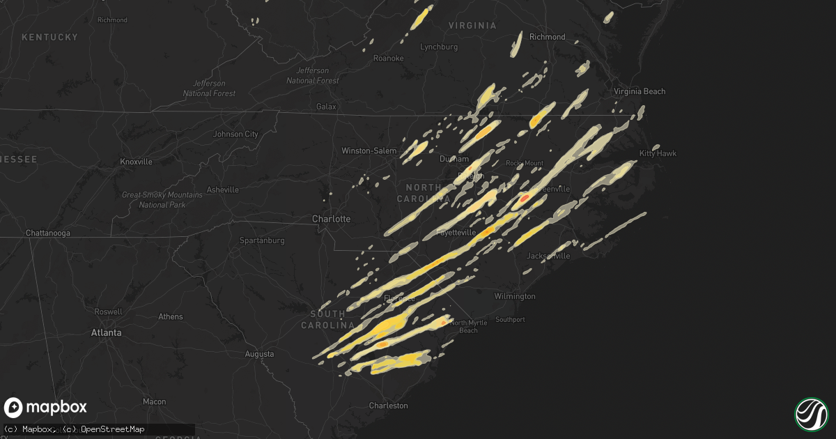
Hail Map in North Carolina on April 16, 2011
Get this storm
April 16 map
$229
one time, instant access
Download today. No call, no setup
Keep the $229
Bought the map and want the full workflow? Apply the entire $229 to a subscription within 7 days. None of it is wasted.
Every map, not just this one
This buys you this map. Subscription and you get every map we run, in the markets you choose from a few cities to whole states to nationwide. Plus real-time alerts the moment a storm fires.
Contact data
Name, contact info, occupancy, even credit band for addresses in the footprint. You go from where it hit to who to call.
Become the source they trust
Unlimited branding weather history reports on demand. You already have the documented answer ready for the property owner, and you are the one who showed up with it.
Property data and RoofTrace estimates
Pull up any address you have got, its value and the exact code rules for that jurisdiction, straight from One Click Code. Then RoofTrace estimates the squares, pitch, and roof value, priced the way you price.
Storm reports in North Carolina
North Carolina
| Date | Description |
|---|---|
| 04/16/20116:48 PM CDT | Tornado spotted on ground. Relayed from 911 center. |
| 04/16/20116:41 PM CDT | Quarter size hail observed west of vanceboro |
| 04/16/20116:30 PM CDT | A local report indicates 1.00 inch wind near SAVAGE |
| 04/16/20116:25 PM CDT | Hwy 41 closed due to debris |
| 04/16/20116:25 PM CDT | Tornado sighted by fire dept near askewville rd. Possible fatalities. |
| 04/16/20116:13 PM CDT | Tornado on the ground near hwy 258 |
| 04/16/20116:11 PM CDT | Home destroyed. Relayed from 911 center |
| 04/16/20116:10 PM CDT | A local report indicates 1.00 inch wind near HAMILTON |
| 04/16/20116:10 PM CDT | Nws storm survey has confirmed an ef-0 tornado touched down briefly near the corner of highway 125 and log cabin road. The tornado tore the roof off a double wide mobil |
| 04/16/20116:00 PM CDT | A local report indicates 1.00 inch wind near 6 NNW WHITEVILLE |
| 04/16/20116:00 PM CDT | Trees down along hwy 42. Relayed from 911 center |
| 04/16/20115:44 PM CDT | Several homes damaged at intersection of kinston hwy and warren taylor rd. Time estimated from radar |
| 04/16/20115:42 PM CDT | Multiple tornados on the ground |
| 04/16/20115:40 PM CDT | 2 homes destroyed |
| 04/16/20115:30 PM CDT | Ef0 tornado touched down near highway 50. Numerous trees snapped off. Minor structural damage to a house. Chicken house had part of roof blown off. |
| 04/16/20115:24 PM CDT | Large trees down on gores trailor rd. Debris on lebanon church rd. |
| 04/16/20115:20 PM CDT | 5 homes with structural damage. Vehicle tipped onto its side. Intersection of hwy264 and hwy258 |
| 04/16/20115:15 PM CDT | House damage and carport blown out |
| 04/16/20115:05 PM CDT | Large trees down on gores trailer rd. Debris on lebanon church rd. Time corrected and estimated by radar. Corrected lat lon. |
| 04/16/20115:01 PM CDT | Andys restaurant destroyed |
| 04/16/20115:01 PM CDT | Roof off of a house on country day road. Additional damage in the area. |
| 04/16/20115:00 PM CDT | Multiple trees down |
| 04/16/20114:59 PM CDT | A local report indicates 1.00 inch wind near 1 NW FARMVILLE |
| 04/16/20114:55 PM CDT | 3 houses destroyed at the intersection of hwy 91 and middle school road |
| 04/16/20114:55 PM CDT | Multiple trees down |
| 04/16/20114:55 PM CDT | Tornado now on the ground near lagrange rd and parkstown rd in saulston. Destroyed large barn at donald turkey farm. |
| 04/16/20114:50 PM CDT | A local report indicates 2.75 inch wind near 2 WSW CONTENTNEA |
| 04/16/20114:45 PM CDT | Roof blown off a sonic. Vacant win dixie damaged. Cars blown around. |
| 04/16/20114:45 PM CDT | Report from greene county emc of 40-50 homes destroyed in greene county along with 5 to 6 businesses. The middle school was severely damaged and the high school gym roo |
| 04/16/20114:42 PM CDT | Golf ball sized hail near snow hill |
| 04/16/20114:40 PM CDT | Time estimated. |
| 04/16/20114:37 PM CDT | Tornado on the ground... Intersect of 701 and 131...corrected lat lon |
| 04/16/20114:37 PM CDT | Tornado on the ground... Intersect of 701 and 131 |
| 04/16/20114:29 PM CDT | A local report indicates 1.00 inch wind near GOLDSBORO |
| 04/16/20114:23 PM CDT | Roof blown off a sonic. Vacant win dixie damaged. Cars blown around. |
| 04/16/20114:22 PM CDT | Law enforcement reported golf ball size hail |
| 04/16/20114:20 PM CDT | Ruptured gas line at 1311 carolina avenue... Roof torn off convalescent home... Patients being evacuated |
| 04/16/20114:17 PM CDT | Numerous cars overturned and buildings destroyed in downtown wilson |
| 04/16/20114:15 PM CDT | Large tornado now on the ground at highway 795. |
| 04/16/20114:12 PM CDT | Trained spotter reported a tornado on the ground in faison near david bryant rd and wade daughtry rd. |
| 04/16/20114:10 PM CDT | Several houses destroyed... Structural damage |
| 04/16/20114:08 PM CDT | Numerous homes destroyed from lucama to wilson. |
| 04/16/20114:08 PM CDT | Turkey barn destroyed on turkey farm road. Time estimated from radar. |
| 04/16/20114:04 PM CDT | Fire department reported tornado on the ground with major damage. |
| 04/16/20113:58 PM CDT | *** 1 fatal *** significant structural damage and 1 fatality in bladenboro area. |
| 04/16/20113:55 PM CDT | Entire mobile home park destroyed near micro between selma and kenly. Over 100 people displaced. |
| 04/16/20113:53 PM CDT | Trees snapped... Mobile home flipped... Boat flipped... Semi truck flipped and blocking i-95 |
| 04/16/20113:53 PM CDT | Trees snapped... Mobile home flipped... Boat flipped... Semi truck flipped and blocking i-95 |
| 04/16/20113:50 PM CDT | Golfball size hail at buffalo rd and old beulah rd. Lasted 5 min. |
| 04/16/20113:50 PM CDT | Time estimated. |
| 04/16/20113:49 PM CDT | Limbs snapped off trees in pinelevel... I-95 closed |
| 04/16/20113:48 PM CDT | Tornado on ground in smithfield. Debris being repored near the hospital. |
| 04/16/20113:47 PM CDT | Several outbuildings knocked over |
| 04/16/20113:45 PM CDT | Tree branches and building debris falling from the sky |
| 04/16/20113:45 PM CDT | Tree branches and building debris falling from the sky |
| 04/16/20113:42 PM CDT | A local report indicates 1.00 inch wind near SMITHFIELD |
| 04/16/20113:40 PM CDT | A local report indicates 1.00 inch wind near SALEMBURG |
| 04/16/20113:40 PM CDT | Mobile home collapsed on hwy 242... 2 miles south of roseboro. Other reports of trees down. |
| 04/16/20113:37 PM CDT | Time estimated. |
| 04/16/20113:36 PM CDT | Grove of 12 to 14 inch diamter pine trees snapped off 20 ft in the air... Trees have fallen on and destroyed trailers |
| 04/16/20113:35 PM CDT | A local report indicates 2.00 inch wind near BENSON |
| 04/16/20113:35 PM CDT | Time estimated. |
| 04/16/20113:35 PM CDT | Hwy 96 blocked by multiple downed trees |
| 04/16/20113:35 PM CDT | Time estimated. |
| 04/16/20113:30 PM CDT | Lasted 5 min. |
| 04/16/20113:29 PM CDT | At highway 301 and ivy road. Funnel cloud also reported at same location. |
| 04/16/20113:25 PM CDT | *** 2 fatal *** em confrims another fatality in ammon area bringing the total to 2. |
| 04/16/20113:25 PM CDT | *** 1 fatal *** widespread damage with homes damaged to destroyed in the benson and black creek area. One confirmed fatality on juniper church road. |
| 04/16/20113:25 PM CDT | Damage near ammon. Sherriff reported a confirmed fatality. |
| 04/16/20113:22 PM CDT | Multiple building destroyed at highway 301 and wise road. |
| 04/16/20113:20 PM CDT | Time estimated. |
| 04/16/20113:20 PM CDT | Structural damage. Roof off food lion grocery store and front window blown out. Numerous cars with windows blown out. Large trees uprooted. |
| 04/16/20113:20 PM CDT | 2 houses gone near dragstrup road and highway 242 |
| 04/16/20113:20 PM CDT | Trailers and other buildings damaged at foundations bible college. |
| 04/16/20113:18 PM CDT | Tree on house. House destroyed. |
| 04/16/20113:17 PM CDT | Numerous trees down near zebulon to north of bunn. |
| 04/16/20113:15 PM CDT | Roof blown off... Trees in road |
| 04/16/20113:15 PM CDT | Roof blown off... Trees in road |
| 04/16/20113:10 PM CDT | Trained spotter reported 89 mph wind gust... Siding blown off building |
| 04/16/20113:10 PM CDT | Golf ball hail at intersection of dunn road and falls of neuse road in raleigh |
| 04/16/20113:06 PM CDT | Quarter size hail on spring forest road in raleigh |
| 04/16/20113:05 PM CDT | *** 3 fatal *** mobiles homes destroyed near brentwood dr in raleigh in hte stonybrook mobile home park. . |
| 04/16/20113:05 PM CDT | *** 1 fatal *** numerous homes damaged to destroyed near linden. One fatality with numerous serious injuries. |
| 04/16/20113:05 PM CDT | Numerous trees down at i-540 and buffaloe rd. Trees 50 ft tall and 1-2 ft diameter. |
| 04/16/20113:03 PM CDT | Reported tornado on ground at river road in wade |
| 04/16/20113:03 PM CDT | Roof damage... Trees sheared off... Trees in the road |
| 04/16/20113:00 PM CDT | Hail shredded leaves and dented cars |
| 04/16/20113:00 PM CDT | Golf ball size hail reported in henderson. |
| 04/16/20113:00 PM CDT | Extensive structural damage... Widespread. Trees down throughout |
| 04/16/20112:59 PM CDT | Power lines and large trees down |
| 04/16/20112:58 PM CDT | Truck overturned... Trees in road... Roof off building at yonkers road |
| 04/16/20112:58 PM CDT | Truck overturned... Trees in road... Roof off building at yonkers road |
| 04/16/20112:58 PM CDT | Numerous brick buildings destrolyed along south saunders street in southeast raleigh. |
| 04/16/20112:57 PM CDT | Numerous trees down. Windows blown out and roofs off buildings at blount and wilmington streets in downtown raleigh. |
| 04/16/20112:57 PM CDT | Downed trees and powerlines |
| 04/16/20112:56 PM CDT | Damage to roof shingles and large pine trees across the road |
| 04/16/20112:56 PM CDT | Tree on house. |
| 04/16/20112:56 PM CDT | Trees on houses on milburnie rd and stevens rd. Power lines on ground. |
| 04/16/20112:55 PM CDT | Large high tension steel wire tower twisted. |
| 04/16/20112:55 PM CDT | A local report indicates 79 MPH wind near FT BRAGG SIMMONS AAF |
| 04/16/20112:55 PM CDT | Measured 73mph gust and snapped trees |
| 04/16/20112:55 PM CDT | Several bldgs partially destroyed at yonkers rd and the beltline. Debris spread up to capital blvd and raleigh iceplex. |
| 04/16/20112:55 PM CDT | Multiple trees down around shaw university. Power lines down on trees and buildings. |
| 04/16/20112:51 PM CDT | Debris falling in north raleigh from large tornado on the ground. |
| 04/16/20112:50 PM CDT | Heavy damage 1600 block of highway 401. Multiple roofs collapsed. Trees down. |
| 04/16/20112:50 PM CDT | Meteorologist reported the roof of earps seafood market on s saunders st partially ripped off. |
| 04/16/20112:50 PM CDT | Debris including foam insulation... Stripped tree branches... And squares of plywood |
| 04/16/20112:50 PM CDT | Many trees down. Several blocking roads. |
| 04/16/20112:50 PM CDT | 8 inch limbs down and blocking 2 lanes of spring forest road in raleigh |
| 04/16/20112:50 PM CDT | Golfball size hail still occurring at uncp. |
| 04/16/20112:50 PM CDT | Time estimated. |
| 04/16/20112:49 PM CDT | Large tree down |
| 04/16/20112:49 PM CDT | Multiple trees blocking the right hand lane of i-40 at exit 298 and hundreds of trees snappee in the woods on either side of the interstate |
| 04/16/20112:49 PM CDT | Trees and power lines down... Buildings destroyed... Debris blocking gilbert st |
| 04/16/20112:48 PM CDT | Multiple power flashes... Rain wrapped tornado at i440 at exit 16 |
| 04/16/20112:48 PM CDT | Multiple power flashes... Rain wrapped tornado at i440 at exit 16 |
| 04/16/20112:47 PM CDT | Several outbuildings knocked over |
| 04/16/20112:47 PM CDT | Roof peeled off buildings at nc state research rarm and lots of trees snapped off. |
| 04/16/20112:46 PM CDT | Quarter size hail covering ground along hwy 211 |
| 04/16/20112:45 PM CDT | Large tornado on the ground. |
| 04/16/20112:44 PM CDT | Tornado on the ground in holly spring. |
| 04/16/20112:40 PM CDT | Straight line wind damage. 100 homes damaged... 4500 people affected. |
| 04/16/20112:38 PM CDT | Golfball size hail near unc-p campus |
| 04/16/20112:36 PM CDT | 2-3 foot diameter trees down |
| 04/16/20112:36 PM CDT | Quarter size hail reported in rowland... Numersous trees down |
| 04/16/20112:36 PM CDT | 2-3 foot diameter trees down |
| 04/16/20112:35 PM CDT | 25 trees down. 18-20 inches in diameter. Other trees broken in half. Structural damage to houses. |
| 04/16/20112:33 PM CDT | Tornado touched down... Took roof off of house. Law enforcement relayed. |
| 04/16/20112:30 PM CDT | Tornado uprooted numerous trees and destroyed a garage near highway 401. |
| 04/16/20112:30 PM CDT | 1.75 inch hail near henderson |
| 04/16/20112:25 PM CDT | A couple trees down along hwy 501 12 miles north of laurinburg. |
| 04/16/20112:25 PM CDT | A couple trees down along hwy 501 12 miles north of laurinburg. |
| 04/16/20112:20 PM CDT | Lowes hardware destroyed |
| 04/16/20112:20 PM CDT | Tornado reported |
| 04/16/20112:17 PM CDT | Multiple trees down in road between seven lakes and carthage |
| 04/16/20112:10 PM CDT | Multiple structures damaged and possible houses collapsed. |
| 04/16/20112:09 PM CDT | Houses damaged and trees down in the st andrews subdivision. |
| 04/16/20112:05 PM CDT | A local report indicates 1.00 inch wind near SANFORD |
| 04/16/20112:05 PM CDT | 4 homes sustained extensive damage... 1 home destroyed... Trees snapped |
| 04/16/20112:03 PM CDT | Cars overturned and trees down |
| 04/16/20111:50 PM CDT | Two 18 inch trees down near union pines high school |
| 04/16/20111:50 PM CDT | *** 4 inj *** confirmed ef-2 tornado. Entered county from person county. Maximum wind speed 120 mph. Maximum path width 300 yards. Path length in va 16.6 miles. Ended 3 |
| 04/16/20111:50 PM CDT | Damage from bethel hill to concord. Six homes demolished. |
| 04/16/20111:40 PM CDT | Power lines down in carr |
| 04/16/20111:40 PM CDT | At country club road... Structural damage to carport... Trees down in road... Trailer flipped |
| 04/16/20111:18 PM CDT | Multiple reports of golf ball size hail in burlington |
| 04/16/20111:15 PM CDT | A local report indicates 1.00 inch wind near BURLINGTON |
| 04/16/20111:13 PM CDT | Possible tornado from 36.25n...m79.34w to 36.27n...m79.305w. 15 sheds destroyed. 1 home destroyed. 4 homes with moderate damage. Numerous trees down. Nws will send inve |
| 04/16/20111:13 PM CDT | Preliminary information from emergency manager of damage to numerous homes in the area with some roofs blown off. Also trees down. |
| 04/16/20111:13 PM CDT | Confirmed ef-1 tornado. Entered the county from alamance county and moved northeast. Maximum wind speed 90 mph. Maximum path width 300 yards. Path length 3.4 miles. 18 |
| 04/16/20111:12 PM CDT | Tree down |
| 04/16/20111:12 PM CDT | Tree down |
| 04/16/20111:10 PM CDT | 2 homes destroyed on hickory nut road... Time estimated by radar |
| 04/16/20111:10 PM CDT | 27 buildings...3 homes...and a barn destroyed on union ridge rd and stoney creek rd. |
| 04/16/20111:08 PM CDT | Trees down... Roofs blown off of houses... Chimneys gone |
| 04/16/20111:08 PM CDT | Trees down... Roofs blown off of houses... Chimneys gone |
| 04/16/20111:02 PM CDT | Limbs down and strong winds observed |
| 04/16/20111:00 PM CDT | Numerous trees down throughout the county. Time estimated. |
| 04/16/201112:50 PM CDT | Tree down on mobile home |
| 04/16/201112:45 PM CDT | Tree down on power line on richardson drive. |
| 04/16/201112:45 PM CDT | Tree down on st. Andrews church road near sanford |
| 04/16/201112:45 PM CDT | Tree down on a house at zoo parkway and newbern avenue |
| 04/16/201112:45 PM CDT | Siding and window damage to a church |
| 04/16/201112:40 PM CDT | Multiple trees down in albemarle |
| 04/16/201112:35 PM CDT | Tree across new home church road... Multiple trees down in morven... Mcfarlan... And lilesville |
| 04/16/201112:24 PM CDT | 1 tree down on haire road |
| 04/16/201112:06 PM CDT | Roof and siding damage to structures along highway 601/concord highway. Trees down as well. |
| 04/16/201112:00 PM CDT | Several trees and power lines down around the county. |
| 04/16/201112:00 PM CDT | Metal roof damage and storage buildings damaged at williams road and highway 74. |
| 04/16/201112:00 PM CDT | Ef0 tornado confirmed 3 miles north of monroe nc. |
| 04/16/201111:45 AM CDT | Estimates of up to 200 trees blown down in a swath along highway 601 north of salisbury. This area will be surveyed for possible tornado on sunday. |
| 04/16/201111:45 AM CDT | Trees and power lines down. |
| 04/16/201111:45 AM CDT | Damage to houses in farrington meadows area of old mocksville road. |
| 04/16/201111:45 AM CDT | Ef0 tornado confirmed 6 miles ese of cooleemee nc. |
| 04/16/201111:45 AM CDT | Ef0 tornado confirmed 5.5 miles ese of cooleemee nc. |
| 04/16/201111:41 AM CDT | Ef1 tornado confirmed 4.5 nnw to 6.5 n of salisbury. |
| 04/16/201111:40 AM CDT | Numerous trees down on highway 150 |
| 04/16/201111:12 AM CDT | One tree blown down along quick road. |
| 04/16/201111:10 AM CDT | Tree down across mallard creek road west of i-85. |
| 04/16/201111:01 AM CDT | Tree down stopping just above and over a mobile home. |
| 04/16/20118:35 AM CDT | Possible tornado. Trees down. 5 houses damaged. Boats blown across road...in vicinity of 8500 block of caratoke hwy. |
| 04/15/20119:25 PM CDT | Powerlines down on ocracoke island |
| 04/15/20118:42 PM CDT | Tree down on hwy 45 towards hwy 264 |
| 04/15/20118:36 PM CDT | Trees and powerlines down in duck and southern shores. Time estimated by radar. |
| 04/15/20118:36 PM CDT | Trees and power poles down on old hwy 64 |
| 04/15/20118:35 PM CDT | 2 roofs blown off houses. Relayed from lwx. |
| 04/15/20118:35 PM CDT | Trees down. 5 houses damaged. Boats blown across road...in vicinity of 8500 block of caratoke hwy. |
| 04/15/20118:35 PM CDT | Possible tornado. Trees down. 5 houses damaged. Boats blown across road...in vicinity of 8500 block of caratoke hwy. |
| 04/15/20118:34 PM CDT | Trees down across hwy 64e near old hwy 64 |
| 04/15/20118:30 PM CDT | Tree down on old hwy 264 next to scranton post office |
| 04/15/20118:30 PM CDT | Nws storm survey determined damage consistent with an efi tornado. Path length of 2.2 miles. The tornado apparently moved inland off the albemarle sound and continued e |
| 04/15/20118:30 PM CDT | Numerous trees and powerlines down |
| 04/15/20118:21 PM CDT | Trees down across hwy 64 near burton shell rd. Relayed from 911 center |
| 04/15/20118:19 PM CDT | Observed 57 kt wind gust on the weatherflow mesonet network |
| 04/15/20118:15 PM CDT | Large tree down |
| 04/15/20118:05 PM CDT | Several roofs and out buildings damaged in the ne part of the county south of the albemarle sound and west of the alligator river |
| 04/15/20118:03 PM CDT | One-inch hail reported at the back gate of cherry point |
| 04/15/20118:00 PM CDT | One inch hail reported by public in havelock |
| 04/15/20117:50 PM CDT | Roof damaged... 24 inch diameter trees snapped... Power poles snapped mills road |
| 04/15/20117:47 PM CDT | Spotter reported roof off home in falcon landing in riverdale. |
| 04/15/20117:32 PM CDT | Half dollar to quarter size hail reported by public at riggs rd in mayesville. |
| 04/15/20117:20 PM CDT | Trees down on road on belvidere road and on poplar neck road. |
| 04/15/20117:18 PM CDT | Public reports tornado touched down in camp lejeune. |
| 04/15/20117:17 PM CDT | Public reports of tornado touched down in the piney green area |
| 04/15/20117:11 PM CDT | Spotter reported wind gust to 70 mph and possibly a brief tornado touchdown at a bojangles on hwy 24 in jacksonville |
| 04/15/20117:10 PM CDT | Nws storm survey confirmed ef2 tornado touched down in tarawa terrace in camp lejeune |
| 04/15/20117:08 PM CDT | Waterspout moved ashore as an ef0 tornado along east front street and moved northeast to the intersection of highway 92 and heron lane. Several trees and large limbs bl |
| 04/15/20117:04 PM CDT | Limbs down. Relayed from 911 center |
All States Impacted by Hail Map on April 16, 2011
Cities Impacted by Hail Map on April 16, 2011
- Efland, NC
- Deep Run, NC
- Kenansville, NC
- Kinston, NC
- Beulaville, NC
- Rose Hill, NC
- Pink Hill, NC
- Dover, NC
- Magnolia, NC
- Trenton, NC
- Roanoke Rapids, NC
- Gaston, NC
- Emporia, VA
- Pleasant Hill, NC
- Garysburg, NC
- Skippers, VA
- Drewryville, VA
- Weldon, NC
- Boykins, VA
- Newsoms, VA
- Lillington, NC
- Reevesville, SC
- Branchville, SC
- Littleton, NC
- Enfield, NC
- New Zion, SC
- Gable, SC
- Andrews, SC
- Lane, SC
- Loris, SC
- Galivants Ferry, SC
- Maysville, NC
- Jacksonville, NC
- New Bern, NC
- Quantico, VA
- Stafford, VA
- Fair Bluff, NC
- Cerro Gordo, NC
- Orangeburg, SC
- Cordova, SC
- Columbia, NC
- Oxford, NC
- Stem, NC
- Burlington, NC
- Julian, NC
- Elon, NC
- Haw River, NC
- Whitsett, NC
- Henderson, NC
- Mebane, NC
- South Hill, VA
- Chase City, VA
- Lunenburg, VA
- Kenbridge, VA
- Boydton, VA
- Baskerville, VA
- Clarksville, VA
- Victoria, VA
- Skipwith, VA
- Conway, SC
- Aynor, SC
- Pawleys Island, SC
- Middleburg, NC
- Norlina, NC
- Creedmoor, NC
- Manson, NC
- Faison, NC
- Dudley, NC
- Mount Olive, NC
- Beaufort, NC
- Rowland, NC
- Summerton, SC
- Lake City, SC
- Olanta, SC
- Coward, SC
- Chadbourn, NC
- Pamplico, SC
- Alcolu, SC
- Elloree, SC
- Pinewood, SC
- Turbeville, SC
- Effingham, SC
- Nichols, SC
- Scranton, SC
- Santee, SC
- Manning, SC
- Greeleyville, SC
- Cades, SC
- Cameron, SC
- Mullins, SC
- Marion, SC
- Kingstree, SC
- Lancaster, VA
- Heathsville, VA
- Franklin, WV
- Merry Hill, NC
- Hertford, NC
- Edenton, NC
- Colerain, NC
- Belvidere, NC
- Windsor, NC
- Tyner, NC
- Steeles Tavern, VA
- Greenville, VA
- Staunton, VA
- Salters, SC
- Clinton, NC
- Vanceboro, NC
- Triangle, VA
- Fredericksburg, VA
- Fork, SC
- Sellers, SC
- Neeses, SC
- Timmonsville, SC
- Latta, SC
- Lynchburg, SC
- Sumter, SC
- Dillon, SC
- Cope, SC
- Lake View, SC
- Saint Matthews, SC
- Orrum, NC
- Lumberton, NC
- Fairmont, NC
- Norway, SC
- Florence, SC
- Mayesville, SC
- Hamer, SC
- Snow Hill, NC
- Pikeville, NC
- Goldsboro, NC
- Stantonsburg, NC
- Walstonburg, NC
- La Grange, NC
- Elkview, WV
- Charleston, WV
- Taneytown, MD
- Hanover, PA
- Littlestown, PA
- Jackson Springs, NC
- West End, NC
- Natural Bridge, VA
- Vesuvius, VA
- Buena Vista, VA
- Fairfield, VA
- Raphine, VA
- Glasgow, VA
- Lexington, VA
- Buchanan, VA
- Natural Bridge Station, VA
- Cary, NC
- Apex, NC
- Raleigh, NC
- Wake Forest, NC
- Autryville, NC
- Fayetteville, NC
- Salemburg, NC
- White Oak, NC
- Roseboro, NC
- Farmville, NC
- Fremont, NC
- Columbia, SC
- Millboro, VA
- New Castle, VA
- Prospect Hill, NC
- Hurdle Mills, NC
- Little Rock, SC
- Harleyville, SC
- Holly Hill, SC
- Elgin, SC
- Aulander, NC
- Robersonville, NC
- Hobbsville, NC
- Tarboro, NC
- Fountain, NC
- Williamston, NC
- Harrellsville, NC
- Oak City, NC
- Lewiston Woodville, NC
- Cofield, NC
- Bethel, NC
- Gatesville, NC
- Greenville, NC
- Ahoskie, NC
- Hamilton, NC
- Westminster, MD
- Bishopville, SC
- Elm City, NC
- Wilson, NC
- Gibsonville, NC
- Greensboro, NC
- Graham, NC
- McLeansville, NC
- Climax, NC
- Fort Bragg, NC
- Lucama, NC
- Saint Stephen, SC
- Bonneau, SC
- Cross, SC
- Pinopolis, SC
- Ernul, NC
- Chocowinity, NC
- Cove City, NC
- Grifton, NC
- Blounts Creek, NC
- Foster, WV
- Ridgeview, WV
- Ashford, WV
- Julian, WV
- Costa, WV
- Nellis, WV
- Peytona, WV
- Lexington, NC
- Salisbury, NC
- Seven Springs, NC
- Laurel Hill, NC
- Bennettsville, SC
- Hamlet, NC
- Bethune, SC
- Kershaw, SC
- Jefferson, SC
- Whiteville, NC
- Evergreen, NC
- Clarkton, NC
- Goshen, VA
- Craigsville, VA
- Haymarket, VA
- Broad Run, VA
- Reidsville, NC
- Browns Summit, NC
- Kenly, NC
- Roxboro, NC
- Chesterfield, SC
- Ruby, SC
- Powhatan, VA
- Amelia Court House, VA
- Carson, VA
- Crozier, VA
- Madison, WV
- Danville, WV
- Alum Creek, WV
- Belle, WV
- Racine, WV
- Hernshaw, WV
- Selma, NC
- Coats, NC
- Erwin, NC
- Clayton, NC
- Benson, NC
- Smithfield, NC
- Four Oaks, NC
- Dunn, NC
- Catawba, VA
- Havelock, NC
- Rowesville, SC
- Bowman, SC
- Jefferson, MD
- Richfield, NC
- Harrells, NC
- Garland, NC
- Eutawville, SC
- Vance, SC
- Delbarton, WV
- Alton, VA
- Lamar, SC
- Tar Heel, NC
- Maxton, NC
- Saint Pauls, NC
- Darlington, SC
- Dalzell, SC
- Shannon, NC
- Hartsville, SC
- Society Hill, SC
- Clio, SC
- Blenheim, SC
- Rembert, SC
- Pembroke, NC
- Red Springs, NC
- Omar, WV
- Summerville, SC
- Moncks Corner, SC
- Saint George, SC
- Georgetown, SC
- Jamestown, SC
- Pineville, SC
- Leesburg, VA
- Zuni, VA
- Carrsville, VA
- Franklin, VA
- Nesmith, SC
- Hemingway, SC
- Johnsonville, SC
- Gresham, SC
- Wallace, SC
- Petersburg, WV
- Monterey, VA
- Petersburg, VA
- Pine Level, NC
- Linden, NC
- Bluemont, VA
- West Point, VA
- Remington, VA
- Midland, VA
- Warrenton, VA
- Bealeton, VA
- Jeffersonton, VA
- Halifax, NC
- Capron, VA
- Branchville, VA
- Camden, SC
- Cassatt, SC
- Kittrell, NC
- Butner, NC
- Wendell, NC
- Williamsburg, VA
- Surry, VA
- Dendron, VA
- Elberon, VA
- Spring Grove, VA
- Waverly, VA
- Broadway, NC
- Sanford, NC
- Murrells Inlet, SC
- Myrtle Beach, SC
- Willow Spring, NC
- Fuquay Varina, NC
- Dickerson, MD
- Adamstown, MD
- Belhaven, NC
- Godwin, NC
- Catlett, VA
- Nokesville, VA
- Rougemont, NC
- Providence Forge, VA
- Lanexa, VA
- Lovettsville, VA
- Swoope, VA
- McBee, SC
- Marston, NC
- Cheraw, SC
- Kitty Hawk, NC
- Mount Croghan, SC
- Purcellville, VA
- Harpers Ferry, WV
- Como, NC
- Pendleton, NC
- Ashburn, VA
- Elkwood, VA
- Sumerduck, VA
- Richardsville, VA
- Louisburg, NC
- Carthage, NC
- Newport, NC
- Winterville, NC
- Hookerton, NC
- Ayden, NC
- Bullock, NC
- Durham, NC
- Ellerbe, NC
- New Hill, NC
- Moncure, NC
- Lilesville, NC
- Candor, NC
- Levels, WV
- Points, WV
- Snow Camp, NC
- Liberty, NC
- Prince Frederick, MD
- Port Republic, MD
- Mechanicsville, MD
- Hague, VA
- Montross, VA
- Dinwiddie, VA
- Patrick, SC
- New Oxford, PA
- Middlesex, NC
- Zebulon, NC
- Waterford, VA
- Hamilton, VA
- Round Hill, VA
- Asheboro, NC
- Sophia, NC
- Trinity, NC
- Pageland, SC
- Nelson, VA
- Buffalo Junction, VA
- Delaplane, VA
- Upperville, VA
- Blue Grass, VA
- Castalia, NC
- Upper Tract, WV
- Front Royal, VA
- Raeford, NC
- Spring Lake, NC
- Macclesfield, NC
- Bahama, NC
- Franklinton, NC
- Warrenton, NC
- Moorefield, WV
- Denton, NC
- Rolesville, NC
- Youngsville, NC
- Holly Springs, NC
- McKenney, VA
- Dewitt, VA
- Wilsons, VA
- Bunnlevel, NC
- Calypso, NC
- Warsaw, NC
- Angier, NC
- Windsor, VA
- Margarettsville, NC
- Courtland, VA
- Hanover, MD
- Newton Grove, NC
- Rockville, VA
- Aberdeen, NC
- Cornelius, NC
- Denver, NC
- Lugoff, SC
- Sterling, VA
- Herndon, VA
- Seaboard, NC
- Jackson, NC
- Manassas, VA
- Linwood, NC
- Hewett, WV
- Turtle Creek, WV
- Seth, WV
- Chapmanville, WV
- Bloomingrose, WV
- Jeffrey, WV
- Walton, WV
- Leasburg, NC
- Rocky Point, NC
- Chesapeake, VA
- Semora, NC
- Yanceyville, NC
- Bamberg, SC
- Knightdale, NC
- Garner, NC
- Brandywine, WV
- Huntingtown, MD
- Gainesville, VA
- Dolphin, VA
- Sugar Grove, WV
- Spotsylvania, VA
- Warfield, VA
- Stony Creek, VA
- Rawlings, VA
- Knotts Island, NC
- Moyock, NC
- Eastover, SC
- Sarah Ann, WV
- La Crosse, VA
- Peachland, NC
- Wadesboro, NC
- Elizabethtown, NC
- Milam, WV
- Bergton, VA
- Mathias, WV
- Bladenboro, NC
- Pope Army Airfield, NC
- Princeton, NC
- Creswell, NC
- Elizabeth City, NC
- Sunbury, NC
- South Mills, NC
- Camden, NC
- Centreville, VA
- Chantilly, VA
- Winchester, VA
- Bath, NC
- Washington, NC
- Hollister, NC
- Turkey, NC
- Pinetops, NC
- Pantego, NC
- Roper, NC
- Augusta, WV
- Slanesville, WV
- Romney, WV
- Scotland Neck, NC
- Wagram, NC
- Virginia Beach, VA
- Mooresville, NC
- Bunn, NC
- Jennings, FL
- Alberta, VA
- Rocky Mount, NC
- Camp Lejeune, NC
- Tarawa Terrace, NC
- Jessup, MD
- Annapolis Junction, MD
- Laurel, MD
- Pinetown, NC


