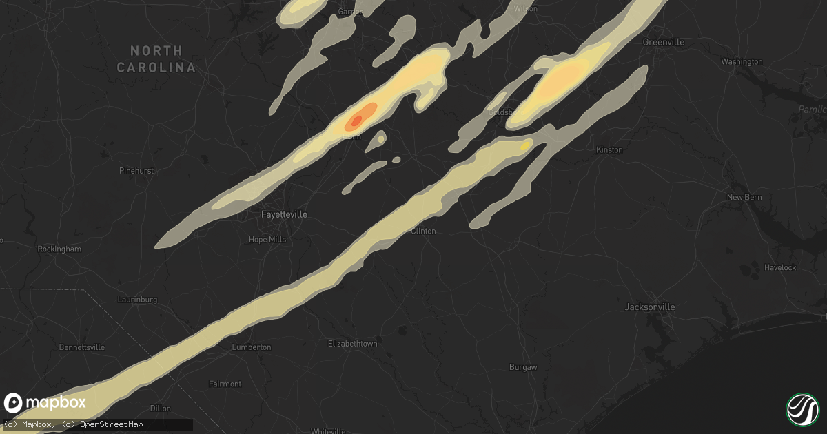
Hail Map in Raleigh, NC on April 16, 2011
Get this storm
April 16 map
$229
one time, instant access
Download today. No call, no setup
Keep the $229
Bought the map and want the full workflow? Apply the entire $229 to a subscription within 7 days. None of it is wasted.
Every map, not just this one
This buys you this map. Subscription and you get every map we run, in the markets you choose from a few cities to whole states to nationwide. Plus real-time alerts the moment a storm fires.
Contact data
Name, contact info, occupancy, even credit band for addresses in the footprint. You go from where it hit to who to call.
Become the source they trust
Unlimited branding weather history reports on demand. You already have the documented answer ready for the property owner, and you are the one who showed up with it.
Property data and RoofTrace estimates
Pull up any address you have got, its value and the exact code rules for that jurisdiction, straight from One Click Code. Then RoofTrace estimates the squares, pitch, and roof value, priced the way you price.
Storm reports in Raleigh, NC
Raleigh, NC
| Date | Description |
|---|---|
| 04/16/20113:10 PM CDT | Golf ball hail at intersection of dunn road and falls of neuse road in raleigh |
| 04/16/20113:10 PM CDT | Trained spotter reported 89 mph wind gust... Siding blown off building |
| 04/16/20113:06 PM CDT | Quarter size hail on spring forest road in raleigh |
| 04/16/20113:05 PM CDT | *** 3 fatal *** mobiles homes destroyed near brentwood dr in raleigh in hte stonybrook mobile home park. . |
| 04/16/20113:05 PM CDT | Numerous trees down at i-540 and buffaloe rd. Trees 50 ft tall and 1-2 ft diameter. |
| 04/16/20113:03 PM CDT | Roof damage... Trees sheared off... Trees in the road |
| 04/16/20113:00 PM CDT | Hail shredded leaves and dented cars |
| 04/16/20112:59 PM CDT | Power lines and large trees down |
| 04/16/20112:58 PM CDT | Numerous brick buildings destrolyed along south saunders street in southeast raleigh. |
| 04/16/20112:58 PM CDT | Truck overturned... Trees in road... Roof off building at yonkers road |
| 04/16/20112:58 PM CDT | Truck overturned... Trees in road... Roof off building at yonkers road |
| 04/16/20112:57 PM CDT | Numerous trees down. Windows blown out and roofs off buildings at blount and wilmington streets in downtown raleigh. |
| 04/16/20112:57 PM CDT | Downed trees and powerlines |
| 04/16/20112:56 PM CDT | Damage to roof shingles and large pine trees across the road |
| 04/16/20112:56 PM CDT | Trees on houses on milburnie rd and stevens rd. Power lines on ground. |
| 04/16/20112:56 PM CDT | Tree on house. |
| 04/16/20112:55 PM CDT | Large high tension steel wire tower twisted. |
| 04/16/20112:55 PM CDT | Multiple trees down around shaw university. Power lines down on trees and buildings. |
| 04/16/20112:55 PM CDT | Several bldgs partially destroyed at yonkers rd and the beltline. Debris spread up to capital blvd and raleigh iceplex. |
| 04/16/20112:51 PM CDT | Debris falling in north raleigh from large tornado on the ground. |
| 04/16/20112:50 PM CDT | Meteorologist reported the roof of earps seafood market on s saunders st partially ripped off. |
| 04/16/20112:50 PM CDT | Debris including foam insulation... Stripped tree branches... And squares of plywood |
| 04/16/20112:50 PM CDT | Many trees down. Several blocking roads. |
| 04/16/20112:50 PM CDT | Heavy damage 1600 block of highway 401. Multiple roofs collapsed. Trees down. |
| 04/16/20112:50 PM CDT | 8 inch limbs down and blocking 2 lanes of spring forest road in raleigh |
| 04/16/20112:49 PM CDT | Multiple trees blocking the right hand lane of i-40 at exit 298 and hundreds of trees snappee in the woods on either side of the interstate |
| 04/16/20112:49 PM CDT | Trees and power lines down... Buildings destroyed... Debris blocking gilbert st |
| 04/16/20112:49 PM CDT | Large tree down |
| 04/16/20112:48 PM CDT | Multiple power flashes... Rain wrapped tornado at i440 at exit 16 |
| 04/16/20112:48 PM CDT | Multiple power flashes... Rain wrapped tornado at i440 at exit 16 |
| 04/16/20112:47 PM CDT | Roof peeled off buildings at nc state research rarm and lots of trees snapped off. |
| 04/16/20112:45 PM CDT | Large tornado on the ground. |
All States Impacted by Hail Map on April 16, 2011
All Cities Impacted by Hail Map on April 16, 2011
- Efland, NC
- Deep Run, NC
- Kenansville, NC
- Kinston, NC
- Beulaville, NC
- Rose Hill, NC
- Pink Hill, NC
- Dover, NC
- Magnolia, NC
- Trenton, NC
- Roanoke Rapids, NC
- Gaston, NC
- Emporia, VA
- Pleasant Hill, NC
- Garysburg, NC
- Skippers, VA
- Drewryville, VA
- Weldon, NC
- Boykins, VA
- Newsoms, VA
- Lillington, NC
- Reevesville, SC
- Branchville, SC
- Littleton, NC
- Enfield, NC
- New Zion, SC
- Gable, SC
- Andrews, SC
- Lane, SC
- Loris, SC
- Galivants Ferry, SC
- Maysville, NC
- Jacksonville, NC
- New Bern, NC
- Quantico, VA
- Stafford, VA
- Fair Bluff, NC
- Cerro Gordo, NC
- Orangeburg, SC
- Cordova, SC
- Columbia, NC
- Oxford, NC
- Stem, NC
- Burlington, NC
- Julian, NC
- Elon, NC
- Haw River, NC
- Whitsett, NC
- Henderson, NC
- Mebane, NC
- South Hill, VA
- Chase City, VA
- Lunenburg, VA
- Kenbridge, VA
- Boydton, VA
- Baskerville, VA
- Clarksville, VA
- Victoria, VA
- Skipwith, VA
- Conway, SC
- Aynor, SC
- Pawleys Island, SC
- Middleburg, NC
- Norlina, NC
- Creedmoor, NC
- Manson, NC
- Faison, NC
- Dudley, NC
- Mount Olive, NC
- Beaufort, NC
- Rowland, NC
- Summerton, SC
- Lake City, SC
- Olanta, SC
- Coward, SC
- Chadbourn, NC
- Pamplico, SC
- Alcolu, SC
- Elloree, SC
- Pinewood, SC
- Turbeville, SC
- Effingham, SC
- Nichols, SC
- Scranton, SC
- Santee, SC
- Manning, SC
- Greeleyville, SC
- Cades, SC
- Cameron, SC
- Mullins, SC
- Marion, SC
- Kingstree, SC
- Lancaster, VA
- Heathsville, VA
- Franklin, WV
- Merry Hill, NC
- Hertford, NC
- Edenton, NC
- Colerain, NC
- Belvidere, NC
- Windsor, NC
- Tyner, NC
- Steeles Tavern, VA
- Greenville, VA
- Staunton, VA
- Salters, SC
- Clinton, NC
- Vanceboro, NC
- Triangle, VA
- Fredericksburg, VA
- Fork, SC
- Sellers, SC
- Neeses, SC
- Timmonsville, SC
- Latta, SC
- Lynchburg, SC
- Sumter, SC
- Dillon, SC
- Cope, SC
- Lake View, SC
- Saint Matthews, SC
- Orrum, NC
- Lumberton, NC
- Fairmont, NC
- Norway, SC
- Florence, SC
- Mayesville, SC
- Hamer, SC
- Snow Hill, NC
- Pikeville, NC
- Goldsboro, NC
- Stantonsburg, NC
- Walstonburg, NC
- La Grange, NC
- Elkview, WV
- Charleston, WV
- Taneytown, MD
- Hanover, PA
- Littlestown, PA
- Jackson Springs, NC
- West End, NC
- Natural Bridge, VA
- Vesuvius, VA
- Buena Vista, VA
- Fairfield, VA
- Raphine, VA
- Glasgow, VA
- Lexington, VA
- Buchanan, VA
- Natural Bridge Station, VA
- Cary, NC
- Apex, NC
- Raleigh, NC
- Wake Forest, NC
- Autryville, NC
- Fayetteville, NC
- Salemburg, NC
- White Oak, NC
- Roseboro, NC
- Farmville, NC
- Fremont, NC
- Columbia, SC
- Millboro, VA
- New Castle, VA
- Prospect Hill, NC
- Hurdle Mills, NC
- Little Rock, SC
- Harleyville, SC
- Holly Hill, SC
- Elgin, SC
- Aulander, NC
- Robersonville, NC
- Hobbsville, NC
- Tarboro, NC
- Fountain, NC
- Williamston, NC
- Harrellsville, NC
- Oak City, NC
- Lewiston Woodville, NC
- Cofield, NC
- Bethel, NC
- Gatesville, NC
- Greenville, NC
- Ahoskie, NC
- Hamilton, NC
- Westminster, MD
- Bishopville, SC
- Elm City, NC
- Wilson, NC
- Gibsonville, NC
- Greensboro, NC
- Graham, NC
- McLeansville, NC
- Climax, NC
- Fort Bragg, NC
- Lucama, NC
- Saint Stephen, SC
- Bonneau, SC
- Cross, SC
- Pinopolis, SC
- Ernul, NC
- Chocowinity, NC
- Cove City, NC
- Grifton, NC
- Blounts Creek, NC
- Foster, WV
- Ridgeview, WV
- Ashford, WV
- Julian, WV
- Costa, WV
- Nellis, WV
- Peytona, WV
- Lexington, NC
- Salisbury, NC
- Seven Springs, NC
- Laurel Hill, NC
- Bennettsville, SC
- Hamlet, NC
- Bethune, SC
- Kershaw, SC
- Jefferson, SC
- Whiteville, NC
- Evergreen, NC
- Clarkton, NC
- Goshen, VA
- Craigsville, VA
- Haymarket, VA
- Broad Run, VA
- Reidsville, NC
- Browns Summit, NC
- Kenly, NC
- Roxboro, NC
- Chesterfield, SC
- Ruby, SC
- Powhatan, VA
- Amelia Court House, VA
- Carson, VA
- Crozier, VA
- Madison, WV
- Danville, WV
- Alum Creek, WV
- Belle, WV
- Racine, WV
- Hernshaw, WV
- Selma, NC
- Coats, NC
- Erwin, NC
- Clayton, NC
- Benson, NC
- Smithfield, NC
- Four Oaks, NC
- Dunn, NC
- Catawba, VA
- Havelock, NC
- Rowesville, SC
- Bowman, SC
- Jefferson, MD
- Richfield, NC
- Harrells, NC
- Garland, NC
- Eutawville, SC
- Vance, SC
- Delbarton, WV
- Alton, VA
- Lamar, SC
- Tar Heel, NC
- Maxton, NC
- Saint Pauls, NC
- Darlington, SC
- Dalzell, SC
- Shannon, NC
- Hartsville, SC
- Society Hill, SC
- Clio, SC
- Blenheim, SC
- Rembert, SC
- Pembroke, NC
- Red Springs, NC
- Omar, WV
- Summerville, SC
- Moncks Corner, SC
- Saint George, SC
- Georgetown, SC
- Jamestown, SC
- Pineville, SC
- Leesburg, VA
- Zuni, VA
- Carrsville, VA
- Franklin, VA
- Nesmith, SC
- Hemingway, SC
- Johnsonville, SC
- Gresham, SC
- Wallace, SC
- Petersburg, WV
- Monterey, VA
- Petersburg, VA
- Pine Level, NC
- Linden, NC
- Bluemont, VA
- West Point, VA
- Remington, VA
- Midland, VA
- Warrenton, VA
- Bealeton, VA
- Jeffersonton, VA
- Halifax, NC
- Capron, VA
- Branchville, VA
- Camden, SC
- Cassatt, SC
- Kittrell, NC
- Butner, NC
- Wendell, NC
- Williamsburg, VA
- Surry, VA
- Dendron, VA
- Elberon, VA
- Spring Grove, VA
- Waverly, VA
- Broadway, NC
- Sanford, NC
- Murrells Inlet, SC
- Myrtle Beach, SC
- Willow Spring, NC
- Fuquay Varina, NC
- Dickerson, MD
- Adamstown, MD
- Belhaven, NC
- Godwin, NC
- Catlett, VA
- Nokesville, VA
- Rougemont, NC
- Providence Forge, VA
- Lanexa, VA
- Lovettsville, VA
- Swoope, VA
- McBee, SC
- Marston, NC
- Cheraw, SC
- Kitty Hawk, NC
- Mount Croghan, SC
- Purcellville, VA
- Harpers Ferry, WV
- Como, NC
- Pendleton, NC
- Ashburn, VA
- Elkwood, VA
- Sumerduck, VA
- Richardsville, VA
- Louisburg, NC
- Carthage, NC
- Newport, NC
- Winterville, NC
- Hookerton, NC
- Ayden, NC
- Bullock, NC
- Durham, NC
- Ellerbe, NC
- New Hill, NC
- Moncure, NC
- Lilesville, NC
- Candor, NC
- Levels, WV
- Points, WV
- Snow Camp, NC
- Liberty, NC
- Prince Frederick, MD
- Port Republic, MD
- Mechanicsville, MD
- Hague, VA
- Montross, VA
- Dinwiddie, VA
- Patrick, SC
- New Oxford, PA
- Middlesex, NC
- Zebulon, NC
- Waterford, VA
- Hamilton, VA
- Round Hill, VA
- Asheboro, NC
- Sophia, NC
- Trinity, NC
- Pageland, SC
- Nelson, VA
- Buffalo Junction, VA
- Delaplane, VA
- Upperville, VA
- Blue Grass, VA
- Castalia, NC
- Upper Tract, WV
- Front Royal, VA
- Raeford, NC
- Spring Lake, NC
- Macclesfield, NC
- Bahama, NC
- Franklinton, NC
- Warrenton, NC
- Moorefield, WV
- Denton, NC
- Rolesville, NC
- Youngsville, NC
- Holly Springs, NC
- McKenney, VA
- Dewitt, VA
- Wilsons, VA
- Bunnlevel, NC
- Calypso, NC
- Warsaw, NC
- Angier, NC
- Windsor, VA
- Margarettsville, NC
- Courtland, VA
- Hanover, MD
- Newton Grove, NC
- Rockville, VA
- Aberdeen, NC
- Cornelius, NC
- Denver, NC
- Lugoff, SC
- Sterling, VA
- Herndon, VA
- Seaboard, NC
- Jackson, NC
- Manassas, VA
- Linwood, NC
- Hewett, WV
- Turtle Creek, WV
- Seth, WV
- Chapmanville, WV
- Bloomingrose, WV
- Jeffrey, WV
- Walton, WV
- Leasburg, NC
- Rocky Point, NC
- Chesapeake, VA
- Semora, NC
- Yanceyville, NC
- Bamberg, SC
- Knightdale, NC
- Garner, NC
- Brandywine, WV
- Huntingtown, MD
- Gainesville, VA
- Dolphin, VA
- Sugar Grove, WV
- Spotsylvania, VA
- Warfield, VA
- Stony Creek, VA
- Rawlings, VA
- Knotts Island, NC
- Moyock, NC
- Eastover, SC
- Sarah Ann, WV
- La Crosse, VA
- Peachland, NC
- Wadesboro, NC
- Elizabethtown, NC
- Milam, WV
- Bergton, VA
- Mathias, WV
- Bladenboro, NC
- Pope Army Airfield, NC
- Princeton, NC
- Creswell, NC
- Elizabeth City, NC
- Sunbury, NC
- South Mills, NC
- Camden, NC
- Centreville, VA
- Chantilly, VA
- Winchester, VA
- Bath, NC
- Washington, NC
- Hollister, NC
- Turkey, NC
- Pinetops, NC
- Pantego, NC
- Roper, NC
- Augusta, WV
- Slanesville, WV
- Romney, WV
- Scotland Neck, NC
- Wagram, NC
- Virginia Beach, VA
- Mooresville, NC
- Bunn, NC
- Jennings, FL
- Alberta, VA
- Rocky Mount, NC
- Camp Lejeune, NC
- Tarawa Terrace, NC
- Jessup, MD
- Annapolis Junction, MD
- Laurel, MD
- Pinetown, NC


