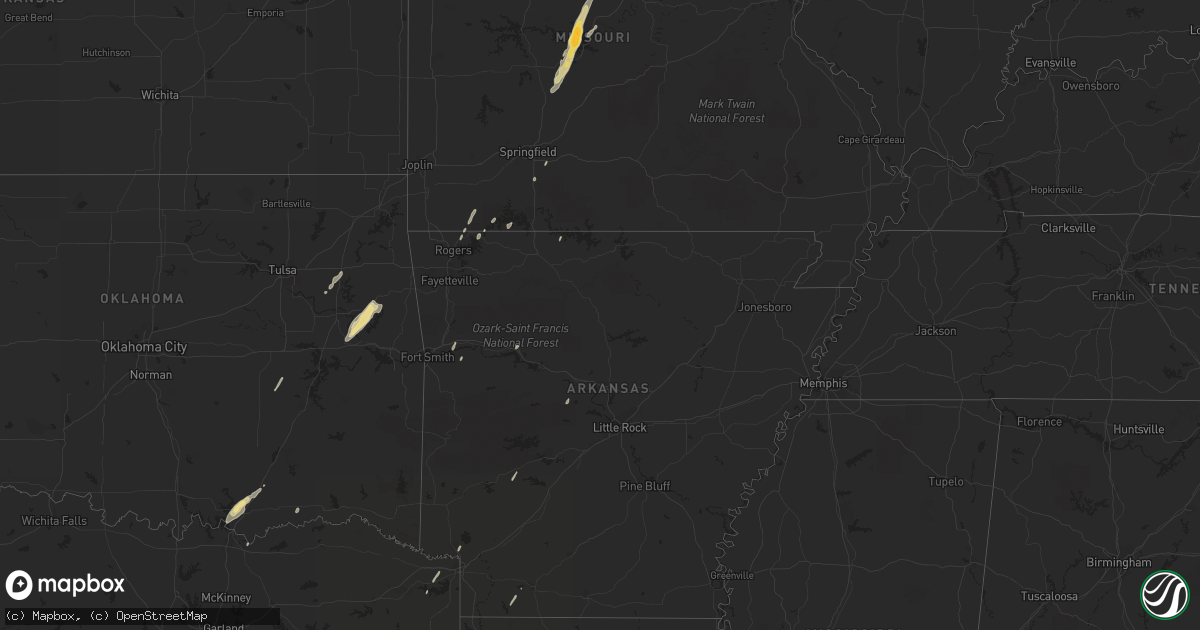
Hail Map in Arkansas on April 15, 2012
Get this storm
April 15 map
$229
one time, instant access
Download today. No call, no setup
Keep the $229
Bought the map and want the full workflow? Apply the entire $229 to a subscription within 7 days. None of it is wasted.
Every map, not just this one
This buys you this map. Subscription and you get every map we run, in the markets you choose from a few cities to whole states to nationwide. Plus real-time alerts the moment a storm fires.
Contact data
Name, contact info, occupancy, even credit band for addresses in the footprint. You go from where it hit to who to call.
Become the source they trust
Unlimited branding weather history reports on demand. You already have the documented answer ready for the property owner, and you are the one who showed up with it.
Property data and RoofTrace estimates
Pull up any address you have got, its value and the exact code rules for that jurisdiction, straight from One Click Code. Then RoofTrace estimates the squares, pitch, and roof value, priced the way you price.
Storm reports in Arkansas
Arkansas
| Date | Description |
|---|---|
| 04/15/20126:18 PM CDT | A power pole was snapped and some trees and power lines were blown down on river ridge road near salem. |
| 04/15/20126:11 PM CDT | Nws storm survey confirmed an ef 1 tornado. The tornado began 3.1 miles southeast of morganton and ended 4.1 miles east of morganton. Path length was 2.3 miles with a w |
| 04/15/20126:09 PM CDT | Trees were blown down onto power lines on arkansas 356. There is a possibility that this was a brief tornado. The time was approximated based on radar. |
| 04/15/201210:15 AM CDT | 2-3 inch tree limbs down. Time radar estimated. |
| 04/15/201210:08 AM CDT | Tree damage. Possible brief tornado touchdown. Time estimated by radar. |
| 04/15/201210:03 AM CDT | Large tree limbs down over north road and a large tree across a county road. Time is radar estimated. |
All States Impacted by Hail Map on April 15, 2012
Cities Impacted by Hail Map on April 15, 2012
- Minneota, MN
- Clarkfield, MN
- Portland, TX
- Gregory, TX
- Taft, TX
- Aransas Pass, TX
- Hector, MN
- Zapata, TX
- Refugio, TX
- Victoria, TX
- Goliad, TX
- Santa Elena, TX
- Rio Grande City, TX
- Roma, TX
- Buffalo, MN
- Montrose, MN
- Waverly, MN
- Hebbronville, TX
- Bayside, TX
- Inez, TX
- Tivoli, TX
- Woodsboro, TX
- Rockport, TX
- Ingleside, TX
- Kenedy, TX
- Corpus Christi, TX
- Edna, TX
- Dawson, MN
- Milwaukee, WI
- Guerra, TX
- Cassville, MO
- Golden, MO
- Shell Knob, MO
- Amity, AR
- Mitchell, SD
- Artesian, SD
- Letcher, SD
- Huntington, TX
- Porter, OK
- Coweta, OK
- Sunrise Beach, MO
- Camdenton, MO
- Gravois Mills, MO
- Lake Ozark, MO
- Groveton, TX
- Macks Creek, MO
- Osage Beach, MO
- Eldon, MO
- Buffalo, MO
- Roach, MO
- Barnett, MO
- Tunas, MO
- Russellville, MO
- Rocky Mount, MO
- Eldridge, MO
- Windyville, MO
- California, MO
- Mapleton, MN
- Lead Hill, AR
- Jamestown, MO
- Muskogee, OK
- Park Hill, OK
- Braggs, OK
- Gore, OK
- Tahlequah, OK
- Warner, OK
- Livingston, TX
- Hopkins, MN
- Premont, TX
- Concepcion, TX
- Tyler, MN
- Yoakum, TX
- Muskego, WI
- Hutchinson, MN
- Savoy, TX
- Bells, TX
- Calera, OK
- Durant, OK
- Caddo, OK
- Mead, OK
- Young America, MN
- New Germany, MN
- Lester Prairie, MN
- Plato, MN
- Minneapolis, MN
- Moscow, TX
- Corrigan, TX
- Brownton, MN
- Logansport, LA
- Joaquin, TX
- Glencoe, MN
- Pipestone, MN
- Tuscumbia, MO
- Kaiser, MO
- Jasper, TX
- Port O'Connor, TX
- Austwell, TX
- Winthrop, MN
- Gaylord, MN
- Good Thunder, MN
- Center, TX
- Brookings, SD
- Volga, SD
- Trinity, TX
- New Auburn, MN
- Colmesneil, TX
- Zavalla, TX
- Beeville, TX
- Winsted, MN
- Mayer, MN
- Howard Lake, MN
- Yorktown, TX
- Douglassville, TX
- Coushatta, LA
- Madisonville, TX
- San Augustine, TX
- Cartwright, OK
- Granite Falls, MN
- Maynard, MN
- Ruthton, MN
- Edgerton, MN
- Holland, MN
- Lake Benton, MN
- Jasper, MN
- Ashdown, AR
- Chouteau, OK
- Wagoner, OK
- Madison, SD
- Mulberry, AR
- Latham, MO
- Green Isle, MN
- Easton, MN
- Minnesota Lake, MN
- Shelbyville, TX
- Milam, TX
- Lynd, MN
- Ghent, MN
- Seligman, MO
- Garfield, AR
- Westhoff, TX
- Canova, SD
- Howard, SD
- Florien, LA
- Many, LA
- Lamar, AR
- Clarksville, AR
- Laredo, TX
- Charleston, AR
- Chester, TX
- Woodville, TX
- Russell, MN
- Lampe, MO
- Robeline, LA
- Natchitoches, LA
- Falfurrias, TX
- Baldwin, WI
- Woodville, WI
- Glenwood City, WI
- Brenham, TX
- Navasota, TX
- Somerville, TX
- Broaddus, TX
- Caney, OK
- Washburn, MO
- Lagrange, IN
- Lamar, OK
- Dustin, OK
- Ozark, MO
- Boswell, OK
- New Prague, MN
- Belle Plaine, MN
- Realitos, TX
- Winfred, SD
- Eureka Springs, AR
- Madison, MN
- Hemphill, TX
- Stamps, AR
- Taylor, AR
- Tilden, TX
- Marthaville, LA
- Waldo, AR
- Rogersville, MO
- Hooks, TX
- Maud, TX
- Newton, TX
- Chireno, TX
- Perryville, AR
- Zwolle, LA
- Noble, LA
- Belmont, LA
- Pleasant Hill, LA
- Cokato, MN
- Hales Corners, WI
- Welling, OK
- Fort Gibson, OK


