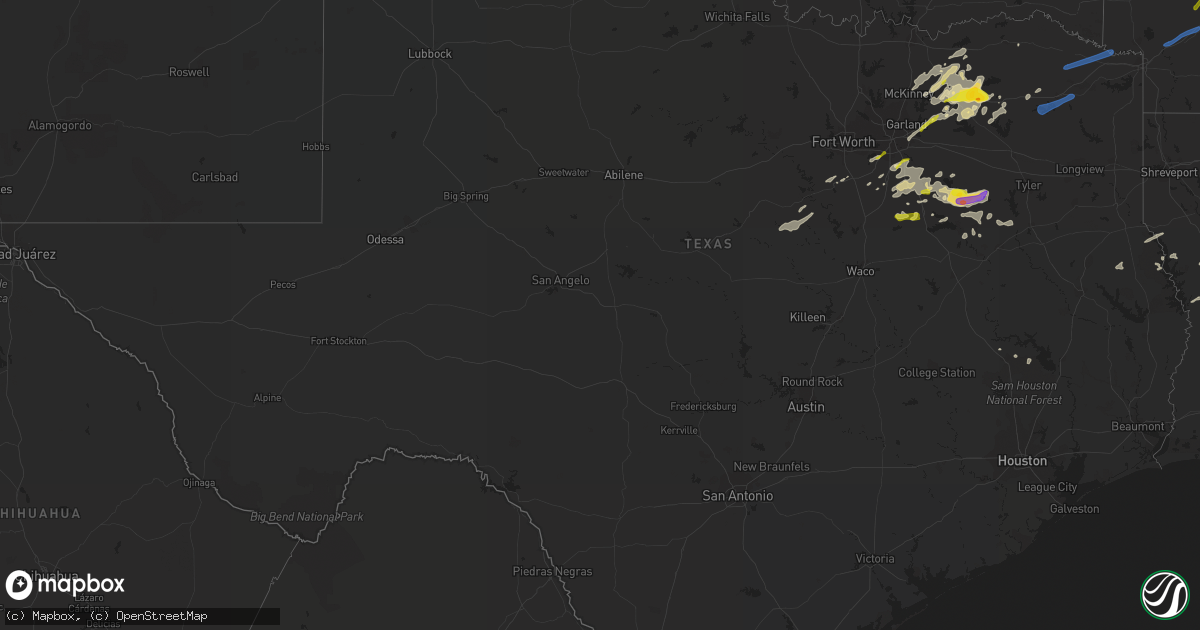
Hail Map in Texas on April 13, 2022
Get this storm
April 13 map
$229
one time, instant access
Download today. No call, no setup
Keep the $229
Bought the map and want the full workflow? Apply the entire $229 to a subscription within 7 days. None of it is wasted.
Every map, not just this one
This buys you this map. Subscription and you get every map we run, in the markets you choose from a few cities to whole states to nationwide. Plus real-time alerts the moment a storm fires.
Contact data
Name, contact info, occupancy, even credit band for addresses in the footprint. You go from where it hit to who to call.
Become the source they trust
Unlimited branding weather history reports on demand. You already have the documented answer ready for the property owner, and you are the one who showed up with it.
Property data and RoofTrace estimates
Pull up any address you have got, its value and the exact code rules for that jurisdiction, straight from One Click Code. Then RoofTrace estimates the squares, pitch, and roof value, priced the way you price.
Storm reports in Texas
Texas
| Date | Description |
|---|---|
| 04/13/20222:18 PM CDT | Trees and power lines down. |
| 04/13/20222:07 PM CDT | Trees snapped and uprooted. |
| 04/13/20221:45 PM CDT | Fire dept/rescue: approximately 20 trees down near cr3103... Roof off of a mobile home... Powerlines down. A building was moved approximately 20 feet from location. Cr3 |
| 04/13/20221:45 PM CDT | Broken power line poles near us hwy 82 and cr3104. |
| 04/13/20221:45 PM CDT | Corrects previous tstm wnd dmg report from 6 wnw new boston. Fire dept/rescue: approximately 20 trees down near cr3103... Roof off of a mobile home... Powerlines down. |
| 04/13/20221:45 PM CDT | Trees and power lines down. |
| 04/13/20221:29 PM CDT | Report from mping: quarter |
| 04/13/20221:23 PM CDT | Report from mping: ping pong ball |
| 04/13/20221:19 PM CDT | A local report indicates 1.50 inch wind near MALAKOFF |
| 04/13/20221:08 PM CDT | A local report indicates 1.00 inch wind near 2 ESE ENCHANTED OAKS |
| 04/13/202212:33 PM CDT | Quarter to golf ball sized hail reported at cumby isd. |
| 04/13/202212:22 PM CDT | Report from mping: quarter |
| 04/13/202212:07 PM CDT | A local report indicates 1.00 inch wind near 2 N GREENVILLE |
| 04/13/202211:49 AM CDT | A local report indicates 1.00 inch wind near CELESTE |
| 04/13/202210:45 AM CDT | Trees and power lines down. |
| 04/13/202210:22 AM CDT | Corrects previous tstm wnd dmg report from 1 wnw mount pleasant. Trees and power lines down. |
| 04/13/202210:17 AM CDT | Reports of trees down in avery!. |
| 04/13/202210:07 AM CDT | Several trees down. |
| 04/13/20228:09 AM CDT | Social media image of measured 1 inch hail. |
| 04/13/20227:54 AM CDT | A local report indicates 1.00 inch wind near DODD CITY |
| 04/13/20227:47 AM CDT | At 1247 PM CDT, severe thunderstorms were located along a line extending from near Deport to East Tawakoni, moving east at 40 mph. HAZARD...60 mph wind gusts and quarter size hail. SOURCE...Radar indicated. IMPACT...Hail damage to vehicles is expected. Expect wind damage to roofs, siding, and trees. Locations impacted include... Winnsboro, Clarksville, Hagansport, Boxelder, Mount Vernon, Quitman, Bogata, Pleasant Grove, Wilkerson, Bagwell, Purley, Forest Hill, Detroit, Winfield, Talco, Alba, Avery, Yantis, Annona and Miller's Cove. |
| 04/13/20227:47 AM CDT | At 1246 PM CDT, severe thunderstorms were located along a line extending from near Wills Point to near Corsicana, moving east at 35 mph. HAZARD...60 mph wind gusts and quarter size hail. SOURCE...Radar indicated. IMPACT...Hail damage to vehicles is expected. Expect wind damage to roofs, siding, and trees. Locations impacted include... Athens, Gun Barrel City, Canton, Wills Point, Grand Saline, Mabank, Chandler, Van, Malakoff, Tool, Kerens, Seven Points, Edgewood, Kemp, Brownsboro, Eustace, Trinidad, Fruitvale, Edom and Enchanted Oaks.This includes Interstate 20 between mile markers 513 and 542. |
| 04/13/20227:21 AM CDT | At 1220 PM CDT, a severe thunderstorm was located near Commerce, moving east at 40 mph. HAZARD...60 mph wind gusts and quarter size hail. SOURCE...Radar indicated. IMPACT...Hail damage to vehicles is expected. Expect wind damage to roofs, siding, and trees. Locations impacted include... Paris, Sulphur Springs, Cooper, Blossom, Cumby, Como, Deport, Cooper Lake Park South Sulphur, Cooper Lake Park Doctors Creek, Roxton, Tira, Pecan Gap and Sun Valley.This includes Interstate 30 between mile markers 110 and 142. |
| 04/13/20226:56 AM CDT | At 1155 AM CDT, a severe thunderstorm was located over Ferris, or 9 miles southeast of Hutchins, moving east at 35 mph. HAZARD...60 mph wind gusts and quarter size hail. SOURCE...Radar indicated. IMPACT...Hail damage to vehicles is expected. Expect wind damage to roofs, siding, and trees. Locations impacted include... Balch Springs, Ennis, Terrell, Seagoville, Forney, Kaufman, Wills Point, Wilmer, Mabank, Crandall, Ferris, Palmer, Combine, Talty, Kemp, Grays Prairie, Cottonwood and Purtis Creek State Park.This includes the following highways... Interstate 20 between mile markers 478 and 520. Interstate 45 between mile markers 254 and 270. |
| 04/13/20226:45 AM CDT | At 1144 AM CDT, severe thunderstorms were located from Farmersville to Leonard, moving east at 30 mph. HAZARD...Quarter size hail. SOURCE...Radar indicated. IMPACT...Damage to vehicles is possible. Locations impacted include... Greenville, Commerce, Farmersville, Leonard, Cooper, Wolfe City, Celeste, Cumby, Campbell, Bailey, Cooper Lake Park Doctors Creek, Roxton, Ladonia, Pecan Gap and Neylandville.This includes Interstate 30 between mile markers 95 and 105. |
| 04/13/20226:13 AM CDT | At 1113 AM CDT, a severe thunderstorm was located near Ogden, or 7 miles north of Texarkana, moving east at 50 mph. HAZARD...60 mph wind gusts and nickel size hail. SOURCE...Radar indicated. IMPACT...Expect damage to roofs, siding, and trees. Locations impacted include... Texarkana, Hope, Ashdown, Mineral Springs, Red Lick, Emmet, Wilton, Blevins, Perrytown, Tollette, Fulton, Washington, Ogden, Saratoga, Richmond, Leary, McCaskill, Ozan, McNab and Oakhaven. |
| 04/13/20225:30 AM CDT | At 1030 AM CDT, severe thunderstorms were located along a line extending from near Wilkerson to near Cookville to near Pittsburg, moving east at 50 mph. HAZARD...60 mph wind gusts. SOURCE...Radar indicated. IMPACT...Expect damage to roofs, siding, and trees. Locations impacted include... Texarkana, Mount Pleasant, Atlanta, Wake Village, Pittsburg, Winnsboro, Leesburg, Nash, Mount Vernon, Daingerfield, Linden, Hughes Springs, Queen City, Naples, Redwater, Maud, Omaha, Red Lick, Cason and Us 259 And I 30 Intersection. |
| 04/13/20224:46 AM CDT | At 945 AM CDT, a severe thunderstorm was located 10 miles southwest of Como, or 13 miles south of Sulphur Springs, moving east northeast at 65 mph. HAZARD...60 mph wind gusts. SOURCE...Radar indicated. IMPACT...Expect damage to roofs, siding, and trees. Locations impacted include... Mount Pleasant, Pittsburg, Winnsboro, Leesburg, Mount Vernon, Quitman, Cason, Cookville, Scroggins, Pleasant Grove, Newsome, Purley, Forest Hill, Winfield, Alba, Yantis, Midway, Miller's Cove, Rocky Mound and Roeder. |
| 04/13/20222:08 AM CDT | At 708 AM CDT, a severe thunderstorm was located near Princeton, or 9 miles northeast of McKinney, moving northeast at 45 mph. HAZARD...Quarter size hail. SOURCE...Radar indicated. IMPACT...Damage to vehicles is possible. Locations impacted include... McKinney, Anna, Princeton, Leonard, Lowry Crossing, Honey Grove, Wolfe City, Celeste, Dodd City, Bailey, Bonham State Park, Melissa, Blue Ridge, Trenton, New Hope, Ladonia, Pecan Gap, Windom and Westminster. |
| 04/13/202212:08 AM CDT | At 507 PM CDT, severe thunderstorms were located along a line extending from 9 miles southeast of Winnfield to near Burr Ferry, moving east at 45 mph. HAZARD...70 mph wind gusts and penny size hail. SOURCE...Radar indicated. IMPACT...Expect considerable tree damage. Damage is likely to mobile homes, roofs, and outbuildings. Locations impacted include... Alexandria, Pineville, Leesville, Boyce, Anacoco, Fort Polk, Alexandria International Airport, Slagle, Toledo Bend Dam, Hineston, Lena, Ball, New Llano, Tioga, Timber Trails, Hutton, Esler Regional Airport, Flatwoods, Otis and Elmer.This includes Interstate 49 between mile markers 75 and 109. |
| 04/12/202210:56 PM CDT | At 356 PM CDT, a severe thunderstorm was located near Zwolle, or 26 miles south of Mansfield, moving east at 40 mph. HAZARD...60 mph wind gusts and quarter size hail. SOURCE...Radar indicated. IMPACT...Hail damage to vehicles is expected. Expect wind damage to roofs, siding, and trees. Locations impacted include... Natchitoches, Milam, Many, Zwolle, Converse, Patroon, Allen, Oak Grove, Pleasant Hill, Provencal, Huxley, Noble, Robeline, Powhatan, Sexton, Belmont, Toledo Bend Reservoir North, Jordans Store, Marthaville and Hagewood. |
| 04/12/202210:46 PM CDT | At 345 AM CDT, a severe thunderstorm was located near Lone Star, or 10 miles southeast of Pittsburg, moving northeast at 30 mph. HAZARD...60 mph wind gusts and quarter size hail. SOURCE...Radar indicated. IMPACT...Hail damage to vehicles is expected. Expect wind damage to roofs, siding, and trees. Locations impacted include... Daingerfield, Hughes Springs, Lone Star, Jenkins, Center Point and Holly Springs. |
| 04/12/20228:59 PM CDT | At 158 PM CDT, severe thunderstorms were located along a line extending from near Winthrop to 10 miles west of Maud, moving northeast at 40 mph. HAZARD...60 mph wind gusts and quarter size hail. SOURCE...Radar indicated. IMPACT...Hail damage to vehicles is expected. Expect wind damage to roofs, siding, and trees. Locations impacted include... Texarkana, Wake Village, Ashdown, Nashville, New Boston, Mineral Springs, Nash, Hooks, Redwater, Maud, Red Lick, Wilton, Tollette, Fulton, Washington, Ogden, Ben Lomond, Mandeville, Saratoga and Richmond. |
| 04/12/20228:46 PM CDT | At 146 PM CDT, a severe thunderstorm was located over Brownsboro, or 15 miles east of Athens, moving east at 45 mph. HAZARD...60 mph wind gusts and quarter size hail. SOURCE...Radar indicated. IMPACT...Hail damage to vehicles is expected. Expect wind damage to roofs, siding, and trees. Locations impacted include... Tyler, Jacksonville, Whitehouse, Gladewater, Lindale, Overton, Bullard, Troup, New London, Arp, Mount Selman, Liberty City, Joinerville, Mixon, Turnertown, Reese, Noonday, New Chapel Hill, Winona and Cuney. |
| 04/12/20228:23 PM CDT | At 123 PM CDT, severe thunderstorms were located along a line extending from near Wilkerson to near Como, moving east at 40 mph. HAZARD...60 mph wind gusts and quarter size hail. SOURCE...Radar indicated. IMPACT...Hail damage to vehicles is expected. Expect wind damage to roofs, siding, and trees. Locations impacted include... Mount Pleasant, Pittsburg, Winnsboro, Leesburg, Naples, Omaha, Cason, Us 259 And I 30 Intersection, Cookville, Scroggins, Newsome, Winfield, Miller's Cove, Rocky Mound, Monticello, Roeder, Harvard, Center Point and Holly Springs. |
All States Impacted by Hail Map on April 13, 2022
Cities Impacted by Hail Map on April 13, 2022
- Kemp, TX
- Kaufman, TX
- Malakoff, TX
- Athens, TX
- Eustace, TX
- Mabank, TX
- Cedar Hill, TX
- Joaquin, TX
- Mansfield, LA
- Center, TX
- Shelbyville, TX
- Williams, IN
- Shoals, IN
- Saint Landry, LA
- Mount Vernon, TX
- Eunice, LA
- Basile, LA
- Dustin, OK
- Henryetta, OK
- Weleetka, OK
- Hanna, OK
- Eufaula, OK
- Flowood, MS
- Park Hill, OK
- Lamar, MS
- Holly Springs, MS
- Cecilia, KY
- Corsicana, TX
- Palestine, TX
- Larue, TX
- Oakdale, LA
- Keene, TX
- Cleburne, TX
- Lone Oak, TX
- Sulphur Springs, TX
- Yantis, TX
- Emory, TX
- Mendenhall, MS
- Many, LA
- Robeline, LA
- Lancaster, TX
- Red Oak, TX
- Ferris, TX
- White Plains, KY
- Nortonville, KY
- Cumby, TX
- Klondike, TX
- Greenville, TX
- Wolfe City, TX
- Commerce, TX
- Farmersville, TX
- Campbell, TX
- Brashear, TX
- Celeste, TX
- Caddo Mills, TX
- Morgan City, LA
- Pierre Part, LA
- Princeton, TX
- Kerens, TX
- Oberlin, LA
- Ville Platte, LA
- Mamou, LA
- Glenmora, LA
- Frost, TX
- Blooming Grove, TX
- Barry, TX
- Osyka, MS
- Horse Branch, KY
- Caneyville, KY
- Melville, LA
- Morganza, LA
- Palmetto, LA
- Port Barre, LA
- Royse City, TX
- Henderson, TN
- Falkner, MS
- Tiplersville, MS
- Ripley, MS
- Walnut, MS
- Hudson, KY
- Zachary, LA
- Dierks, AR
- Dodd City, TX
- Bonham, TX
- Waxahachie, TX
- Saint Martinville, LA
- Red Banks, MS
- Maringouin, LA
- Lottie, LA
- Franklin, LA
- Noble, LA
- Converse, LA
- Palmer, TX
- Ennis, TX
- Brinkley, AR
- Pineville, LA
- Alexandria, LA
- Berwick, LA
- Campti, LA
- Ventress, LA
- Hamburg, AR
- Bethel Springs, TN
- Finger, TN
- Natchez, LA
- Natchitoches, LA
- Quinlan, TX
- Rineyville, KY
- Elizabethtown, KY
- Vine Grove, KY
- Highlandville, MO
- Alvarado, TX
- San Augustine, TX
- Nacogdoches, TX
- Murchison, TX
- Trinidad, TX
- Rice, TX
- Jackson, MS
- Richland, MS
- New Roads, LA
- New Iberia, LA
- Iuka, MS
- Napoleonville, LA
- Grosse Tete, LA
- Garfield, KY
- Eastview, KY
- Leitchfield, KY
- Big Clifty, KY
- Custer, KY
- Saltillo, TX
- Leonard, TX
- Oakhurst, TX
- Coldspring, TX
- Jeanerette, LA
- Welling, OK
- Midlothian, TX
- Venus, TX
- Tennessee Colony, TX
- Cloutierville, LA
- Delcambre, LA
- Erath, LA
- Portland, AR
- Parkdale, AR
- Cookson, OK
- Tahlequah, OK
- Ladonia, TX
- Sunnyvale, TX
- Blue Ridge, TX
- Pecan Gap, TX
- Trenton, TX
- Bailey, TX
- Rockwall, TX
- Mckinney, TX
- Melissa, TX
- Anna, TX
- Mesquite, TX
- Nevada, TX
- Cooper, TX
- Evergreen, LA
- Morrow, LA
- Saint Francisville, LA
- Windom, TX
- Brandon, MS
- Broussard, LA
- Rosser, TX
- Wilmer, TX
- Chatfield, TX
- Scurry, TX
- Bunkie, LA
- Farmington, MO
- Fredericktown, MO
- Cottonport, LA
- Opelousas, LA
- Iredell, TX
- Huntsville, TX
- Batchelor, LA
- Reagan, TN
- Lexington, TN
- Carthage, AR
- Port Allen, LA
- Pearl, MS
- Washington, LA
- Sunrise Beach, MO
- Camdenton, MO
- Bedford, IN
- Hornbeck, LA
- Leesville, LA
- Anacoco, LA
- Cromwell, KY
- Flora, MS
- Montalba, TX
- Frankston, TX
- Krotz Springs, LA
- Honey Grove, TX
- Morgan, TX
- Walnut Springs, TX
- Meridian, TX
- Hico, TX
- Joshua, TX
- Godley, TX
- Duson, LA
- Scott, LA
- McDaniels, KY
- Falls Of Rough, KY
- Colfax, LA
- Lecompte, LA
- Forest Hill, LA
- Stilwell, OK
- Lambert, MS
- Florien, LA
- Iota, LA
- Moreauville, LA
- Provencal, LA
- Kentwood, LA
- Greensburg, LA
- Bentley, LA
- Dry Prong, LA
- Pollock, LA
- Ball, LA
- Clarendon, AR
- Holly Grove, AR
- Roe, AR
- Grapevine, AR
- Milam, TX
- Council Hill, OK
- Lena, LA
- Patterson, LA
- Gibson, LA
- Lettsworth, LA
- Simmesport, LA
- Ponchatoula, LA
- Hammond, LA
- Blossom, TX
- Strong, AR
- Erwinville, LA
- Glynn, LA
- Terry, MS
- Raymond, MS
- Byram, MS
- Glen Rose, TX
- Magnolia, MS
- Ashland, MS
- Montgomery, LA
- Church Point, LA
- Plaucheville, LA
- Morgantown, KY
- Pinson, TN
- Mitchell, IN
- Norman, IN
- Heltonville, IN
- Freetown, IN
- Medora, IN
- Brownstown, IN
- Seymour, IN
- Perryville, AR
- Plainview, AR
- Marshall, AR
- Norfork, AR
- Harriet, AR
- Calico Rock, AR
- Hope, AR
- Emmet, AR
- Prescott, AR
- Fulton, AR
- Benton, AR
- Traskwood, AR
- Bauxite, AR
- Alexander, AR
- Roland, AR
- Little Rock, AR
- North Little Rock, AR
- Osceola, AR
- Marked Tree, AR
- Cherry Valley, AR
- Lepanto, AR
- Etowah, AR
- Steele, MO
- Caruthersville, MO
- Hayti, MO
- Monette, AR
- Brookland, AR
- Hornersville, MO
- Leachville, AR
- Lake City, AR
- Jonesboro, AR
- Lake Cormorant, MS
- Casscoe, AR
- De Valls Bluff, AR
- Almyra, AR
- Coldwater, MS
- Hughes, AR
- West Helena, AR
- Crocketts Bluff, AR
- Walls, MS
- Poplar Grove, AR
- Tunica, MS
- Robinsonville, MS
- Marvell, AR
- Wabbaseka, AR
- De Witt, AR
- Altheimer, AR
- Brickeys, AR
- Humphrey, AR
- Marianna, AR
- Lexa, AR
- Helena, AR
- Moro, AR
- Hernando, MS
- Saint Charles, AR
- Dundee, MS
- Stuttgart, AR
- Aubrey, AR
- Brownsville, TN
- Bells, TN
- Stanton, TN
- Silver Point, TN
- Mount Juliet, TN
- Milton, TN
- Burns, TN
- Brentwood, TN
- Pegram, TN
- Dickson, TN
- Clarkrange, TN
- Gainesboro, TN
- La Vergne, TN
- Allred, TN
- Chestnut Mound, TN
- Kingston Springs, TN
- Smyrna, TN
- Pleasant Shade, TN
- Bloomington Springs, TN
- Hickman, TN
- Livingston, TN
- Antioch, TN
- Hermitage, TN
- Rickman, TN
- Gordonsville, TN
- Waverly, TN
- Alexandria, TN
- Nashville, TN
- Cookeville, TN
- Only, TN
- Fairview, TN
- Bon Aqua, TN
- Brush Creek, TN
- New Johnsonville, TN
- Liberty, TN
- Hurricane Mills, TN
- Alpine, TN
- Carthage, TN
- Buffalo Valley, TN
- Lascassas, TN
- Celina, TN
- Monroe, TN
- Wilder, TN
- Dowelltown, TN
- Watertown, TN
- Monterey, TN
- Franklin, TN
- Baxter, TN
- Nunnelly, TN
- Riddleton, TN
- Crawford, TN
- Lancaster, TN
- White Bluff, TN
- Lyles, TN
- Centerville, TN
- Whitleyville, TN
- Murfreesboro, TN
- Duck River, TN
- Smithville, TN
- Elmwood, TN
- McEwen, TN
- Primm Springs, TN
- Granville, TN
- Hilham, TN
- Lebanon, TN
- Charlotte, TN
- Olivehill, TN
- Mount Pleasant, TN
- Clifton, TN
- Savannah, TN
- Adamsville, TN
- Westpoint, TN
- Waynesboro, TN
- Lutts, TN
- Shelbyville, TN
- Columbia, TN
- Leoma, TN
- Belfast, TN
- Pulaski, TN
- Loretto, TN
- Lynnville, TN
- Petersburg, TN
- Cornersville, TN
- Culleoka, TN
- Summertown, TN
- Ethridge, TN
- Collinwood, TN
- Hohenwald, TN
- Lewisburg, TN
- Lawrenceburg, TN
- Crump, TN
- Walling, TN
- Crossville, TN
- Evensville, TN
- Rock Island, TN
- Mcminnville, TN
- Pikeville, TN
- Sparta, TN
- Spencer, TN
- Quebeck, TN
- Doyle, TN
- Dayton, TN
- Spring City, TN
- Woodbury, TN
- Grandview, TN
- Springville, IN
- Waterford, MS
- Sardis, MS
- Como, MS
- Abbeville, MS
- Oxford, MS
- University, MS
- Crenshaw, MS
- Potts Camp, MS
- Taylor, MS
- Sarah, MS
- Senatobia, MS
- Batesville, MS
- Thaxton, MS
- Pope, MS
- Enid, MS
- Lyon, MS
- Clarksdale, MS
- Oakland, MS
- Coahoma, MS
- Courtland, MS
- Sledge, MS
- Marks, MS
- Vance, MS
- Byhalia, MS
- Pocahontas, TN
- Moscow, TN
- La Grange, TN
- Rienzi, MS
- Rossville, TN
- Hickory Valley, TN
- Middleton, TN
- Williston, TN
- Hickory Flat, MS
- Grand Junction, TN
- Collierville, TN
- Michigan City, MS
- Corinth, MS
- Blue Mountain, MS
- Saulsbury, TN
- Sawyerville, AL
- Faunsdale, AL
- Raleigh, MS
- Bolton, MS
- Quitman, MS
- Florence, MS
- Lake, MS
- Bay Springs, MS
- Edwards, MS
- Petal, MS
- Seminary, MS
- Livingston, AL
- Demopolis, AL
- Pachuta, MS
- Vossburg, MS
- Gilbertown, AL
- Forkland, AL
- Ridgeland, MS
- Uniontown, AL
- Silas, AL
- Soso, MS
- Tougaloo, MS
- Richton, MS
- Conehatta, MS
- Cuba, AL
- Chatom, AL
- Needham, AL
- Utica, MS
- Mize, MS
- Sweet Water, AL
- Clinton, MS
- Moselle, MS
- Pulaski, MS
- Bellamy, AL
- Stonewall, MS
- Fruitdale, AL
- Lawrence, MS
- Thomasville, AL
- Waynesboro, MS
- Enterprise, MS
- Tallulah, LA
- Toomsuba, MS
- Deer Park, AL
- Millry, AL
- Greensboro, AL
- Laurel, MS
- Stringer, MS
- Shubuta, MS
- York, AL
- Ellisville, MS
- Boligee, AL
- Chunky, MS
- Meridian, MS
- Louin, MS
- Toxey, AL
- Decatur, MS
- Newbern, AL
- Ovett, MS
- Lisman, AL
- Saint Stephens, AL
- Hickory, MS
- State Line, MS
- Ward, AL
- Coffeeville, AL
- Morton, MS
- Buckatunna, MS
- Vicksburg, MS
- Pelahatchie, MS
- Butler, AL
- Forest, MS
- Collins, MS
- Rose Hill, MS
- Heidelberg, MS
- Marion, AL
- Melvin, AL
- Linden, AL
- Paulding, MS
- Newellton, LA
- Newton, MS
- Taylorsville, MS
- Gallion, AL
- Jachin, AL
- Frankville, AL
- Jackson, AL
- Pennington, AL
- Camden, MS
- Canton, MS
- Kosciusko, MS
- Carthage, MS
- Columbus, MS
- Scooba, MS
- Brooksville, MS
- Philadelphia, MS
- Shuqualak, MS
- Noxapater, MS
- Crawford, MS
- Louisville, MS
- Macon, MS
- Preston, MS
- De Kalb, MS
- Monterey, LA
- Woodville, MS
- Angola, LA
- Grayson, LA
- Louisville, KY
- Greensburg, IN
- Redwood, MS
- Berry, AL
- Eutaw, AL
- Akron, AL
- Moundville, AL
- Water Valley, KY
- Mayfield, KY
- Benton, KY
- Eddyville, KY
- Cadiz, KY
- Upton, KY
- Buffalo, KY
- Hodgenville, KY
- Mount Sherman, KY
- Taylorsville, KY
- Shelbyville, KY
- Waddy, KY
- Westport, IN
- Troy, TN
- Obion, TN
- Hickman, KY
- Hornbeak, TN
- Union City, TN
- Fulton, KY
- Wingo, KY
- Gilbertsville, KY
- Kirksey, KY
- Kuttawa, KY
- South Fulton, TN
- Rockport, KY
- Cub Run, KY
- Mammoth Cave, KY
- Drakesboro, KY
- Brownsville, KY
- Greenville, KY
- Clarkson, KY
- Graham, KY
- Beaver Dam, KY
- Powderly, KY
- Sweeden, KY
- Central City, KY
- Bee Spring, KY
- Roundhill, KY
- Sharon Grove, KY
- Lewisburg, KY
- Olmstead, KY
- Orlinda, TN
- Elkton, KY
- Trenton, KY
- Franklin, KY
- Springfield, TN
- Russellville, KY
- Oak Grove, KY
- Allensville, KY
- Gracey, KY
- Pembroke, KY
- Auburn, KY
- Adairville, KY
- Hopkinsville, KY
- Guthrie, KY
- Fordsville, KY
- Hartford, KY
- Dover, KY
- Russellville, OH
- Richmond, KY
- Bagdad, KY
- Aberdeen, OH
- Nicholasville, KY
- Harned, KY
- Brooks, KY
- West Union, OH
- Brandenburg, KY
- Maysville, KY
- Germantown, KY
- Chaplin, KY
- Frankfort, KY
- Stamping Ground, KY
- Mount Washington, KY
- Berry, KY
- Clermont, KY
- West Point, KY
- Lebanon Junction, KY
- Georgetown, KY
- Webster, KY
- Guston, KY
- Ewing, KY
- Lexington, KY
- Shepherdsville, KY
- Brooksville, KY
- Finchville, KY
- Simpsonville, KY
- Fairfield, KY
- Wilmore, KY
- Ekron, KY
- Mayslick, KY
- Millersburg, KY
- Paris, KY
- Falmouth, KY
- Lawrenceburg, KY
- Mount Eden, KY
- Elizabeth, IN
- Midway, KY
- Bardstown, KY
- Laconia, IN
- Manchester, OH
- Muldraugh, KY
- Irvington, KY
- Versailles, KY
- Bloomfield, KY
- Georgetown, OH
- Fisherville, KY
- Carlisle, KY
- Ripley, OH
- Fairdale, KY
- Winchester, KY
- Hardinsburg, KY
- Mount Olivet, KY
- Augusta, KY
- Salvisa, KY
- Coxs Creek, KY
- Cynthiana, KY
- Stanford, KY
- Danville, KY
- Crab Orchard, KY
- Irvine, KY
- Paint Lick, KY
- Lancaster, KY
- Berea, KY
- Waco, KY
- Greensburg, KY
- Canmer, KY
- Summersville, KY
- Magnolia, KY
- Campbellsville, KY
- Clinton, KY
- Sonora, KY
- Duncanville, TX
- Desoto, TX
- Dallas, TX
- Delight, AR
- Okolona, AR
- Antoine, AR
- Bismarck, AR
- Story, AR
- Mount Ida, AR
- Sims, AR
- Cookville, TX
- Leesburg, TX
- Scroggins, TX
- Pittsburg, TX
- Mount Pleasant, TX
- Omaha, TX
- Avery, TX
- Annona, TX
- New Boston, TX
- Foreman, AR
- De Kalb, TX
- Valley Park, MS
- Columbia, LA
- Winnfield, LA
- Winnsboro, LA
- Delhi, LA
- Sondheimer, LA
- Madison, MS
- Bentonia, MS
- Mangham, LA
- Sikes, LA
- Rayville, LA
- Satartia, MS
- Baskin, LA
- Olla, LA
- Tullos, LA
- Kelly, LA
- Epps, LA
- Yazoo City, MS
- Pioneer, LA
- Mayersville, MS
- Rolling Fork, MS
- Lake Providence, LA
- Transylvania, LA
- Tinsley, MS
- Cary, MS
- Hazlehurst, MS
- Lorman, MS
- Hermanville, MS
- Clayton, LA
- Waterproof, LA
- Saint Joseph, LA
- Port Gibson, MS
- Gilbert, LA
- Sicily Island, LA
- Wisner, LA
- Crystal Springs, MS


