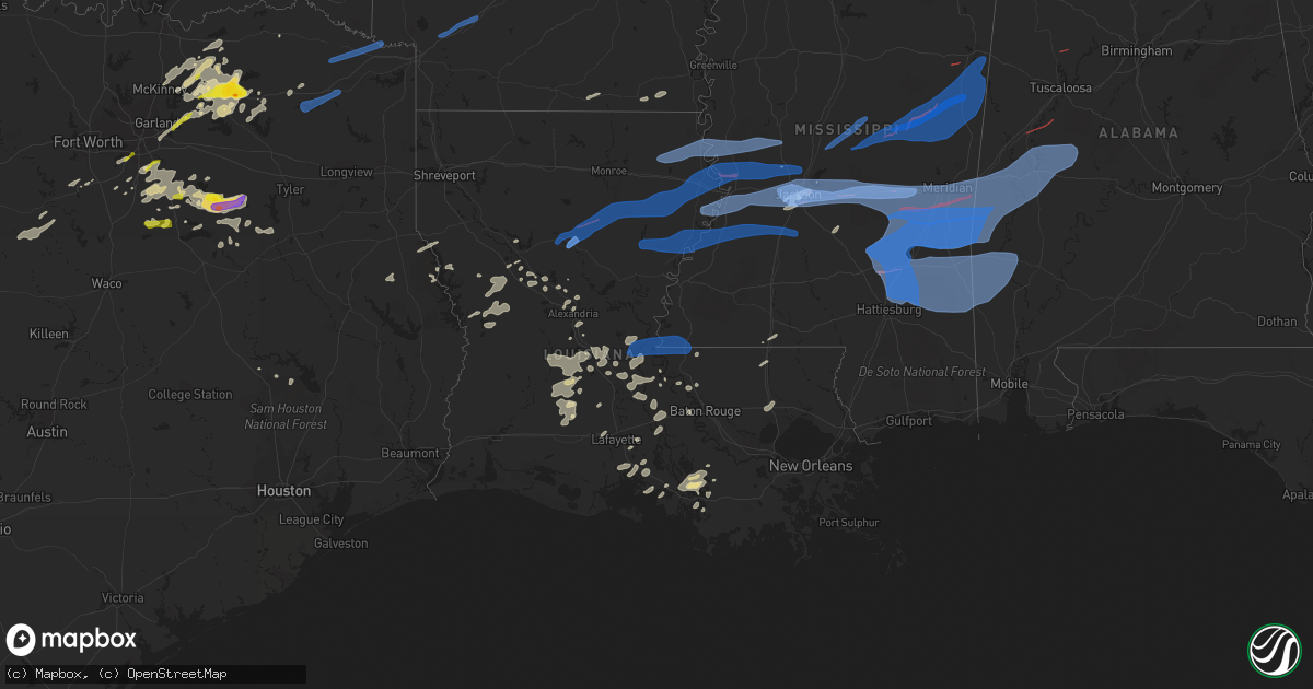
Hail Map in Louisiana on April 13, 2022
Get this storm
April 13 map
$229
one time, instant access
Download today. No call, no setup
Keep the $229
Bought the map and want the full workflow? Apply the entire $229 to a subscription within 7 days. None of it is wasted.
Every map, not just this one
This buys you this map. Subscription and you get every map we run, in the markets you choose from a few cities to whole states to nationwide. Plus real-time alerts the moment a storm fires.
Contact data
Name, contact info, occupancy, even credit band for addresses in the footprint. You go from where it hit to who to call.
Become the source they trust
Unlimited branding weather history reports on demand. You already have the documented answer ready for the property owner, and you are the one who showed up with it.
Property data and RoofTrace estimates
Pull up any address you have got, its value and the exact code rules for that jurisdiction, straight from One Click Code. Then RoofTrace estimates the squares, pitch, and roof value, priced the way you price.
Storm reports in Louisiana
Louisiana
| Date | Description |
|---|---|
| 04/13/20226:25 PM CDT | Tree down near justin and evans road. |
| 04/13/20226:17 PM CDT | Power pole down and tractor shed damaged. |
| 04/13/20226:15 PM CDT | Multiple trees down in the area... Power lines down. |
| 04/13/20226:00 PM CDT | Numerous trees and powerlines down around the parish... Including along highway 577... Highway 857... Bakers cutoff... Roscoe and aj stephens. |
| 04/13/20225:55 PM CDT | Numerous trees down across the southern portions of the parish. |
| 04/13/20225:50 PM CDT | A tree down. |
| 04/13/20225:37 PM CDT | A tree was blown down on grover atwell road near highway 165. |
| 04/13/20225:30 PM CDT | Roof blown off of a home and onto a car along hwy 165. |
| 04/13/20225:28 PM CDT | Trees down on bellview lane just east of columbia. |
| 04/13/20225:28 PM CDT | Trees down at 1759 highway 850 near grayson. |
| 04/13/20225:26 PM CDT | A tree was blown down onto power lines on brooks road near dry prong. |
| 04/13/20225:22 PM CDT | Trees were downed in olla. An antenna was blown down at a substation in town. |
| 04/13/20225:20 PM CDT | Numerous trees were downed across western caldwell parish... Including highway 126 west... Highway 4 west... Childress road... And wiles road. Insulation was blown off |
| 04/13/20225:10 PM CDT | A tree was downed on oak lane southeast of montgomery. |
| 04/13/20225:00 PM CDT | Numerous trees and power lines down. |
| 04/13/20224:45 PM CDT | A tree was downed on highway 1227 northeast of clarence. |
| 04/13/20224:45 PM CDT | A tree was downed on highway 1227 northeast of clarence. (sh i |
| 04/13/20224:42 PM CDT | Trees and power lines down. |
| 04/13/20224:40 PM CDT | A tree was downed on highway 480 east-southeast of campti. |
| 04/13/20224:30 PM CDT | Multiple trees and power lines down. |
| 04/13/20223:45 PM CDT | Several trees down along hwy 79. |
| 04/13/20227:22 AM CDT | At 1222 AM CDT, severe thunderstorms were located along a line extending from near Jones to near Darnell to near Mangham, moving east at 50 mph. HAZARD...60 mph wind gusts and penny size hail. SOURCE...Radar indicated. IMPACT...Expect damage to roofs, siding, and trees. Severe thunderstorms will be near... Monticello around 1225 AM CDT. Transylvania and Alsatia around 1240 AM CDT. Lake Providence, Millikin and Shelburn around 1245 AM CDT. Tallulah around 100 AM CDT.Other locations impacted by these severe thunderstorms include Mound,Delta and Richmond. |
| 04/13/20224:55 AM CDT | At 955 PM CDT, a severe thunderstorm was located near Baxterville, or 9 miles east of Sandy Hook, moving east at 55 mph. HAZARD...60 mph wind gusts. SOURCE...Radar indicated. IMPACT...Expect damage to roofs, siding, and trees. This severe thunderstorm will be near... Lumberton around 1005 PM CDT. Purvis around 1010 PM CDT. Rock Hill around 1015 PM CDT. Brooklyn and Maxie around 1025 PM CDT. |
| 04/13/20224:03 AM CDT | At 902 PM CDT, a severe thunderstorm was located near Oak Grove, or near West Hattiesburg, moving east at 50 mph. HAZARD...60 mph wind gusts. SOURCE...Radar indicated. IMPACT...Expect damage to roofs, siding, and trees. This severe thunderstorm will be near... Hattiesburg around 910 PM CDT. Petal around 915 PM CDT. Sunrise around 920 PM CDT. Mclaurin around 925 PM CDT. |
| 04/13/20223:24 AM CDT | At 824 PM CDT, severe thunderstorms were located along a line extending from near Bayou Current to near Mamou, moving east at 40 mph. HAZARD...60 mph wind gusts and quarter size hail. SOURCE...Radar indicated. IMPACT...Hail damage to vehicles is expected. Expect wind damage to roofs, siding, and trees. Locations impacted include... Opelousas, Ville Platte, Mamou, Krotz Springs, Leonville, Melville, Palmetto, Bayou Current, Morrow, Port Barre, Washington, Chataignier, Prairie Ronde, Lawtell, Whiteville, Big Cane, Reddell, Grand Prairie and Lebeau.This includes Interstate 49 between mile markers 16 and 41. |
| 04/13/20222:42 AM CDT | At 742 PM CDT, severe thunderstorms were located along a line extending from near Evergreen to Allen Parish Airport, moving east at 20 mph. HAZARD...60 mph wind gusts and quarter size hail. SOURCE...Radar indicated. IMPACT...Hail damage to vehicles is expected. Expect wind damage to roofs, siding, and trees. Locations impacted include... Oakdale, Ville Platte, Bunkie, Mamou, Turkey Creek, Morrow, Pine Prairie, Evergreen, Bayou Chicot, Goudeau, Indian Lake, Chicot State Park, Allen Parish Airport, Whiteville, Big Cane, Beaver, Reddell, Bond, Grand Prairie and St. Landry.This includes Interstate 49 between mile markers 33 and 54. |
| 04/13/20222:28 AM CDT | At 728 PM CDT, severe thunderstorms were located along a line extending from near Effie to near Bunkie, moving east at 40 mph. HAZARD...60 mph wind gusts and penny size hail. SOURCE...Radar indicated. IMPACT...Expect damage to roofs, siding, and trees. Locations impacted include... Marksville, Bunkie, Simmesport, Moreauville, Bordelonville, Effie, Cottonport, Mansura, Hessmer, Evergreen, Plaucheville, Brouillette, Lake Ophelia National Wildlife Refuge, Dupont, Big Bend and Hamburg. |
| 04/13/20222:04 AM CDT | At 703 PM CDT, a severe thunderstorm was located near Glenmora, moving east at 40 mph. HAZARD...70 mph wind gusts and penny size hail. SOURCE...Radar indicated. IMPACT...Expect considerable tree damage. Damage is likely to mobile homes, roofs, and outbuildings. Locations impacted include... Bunkie, Glenmora, Turkey Creek, Morrow, Pine Prairie, Evergreen, Bayou Chicot, Goudeau, Indian Lake, Chicot State Park, Whiteville, Big Cane, Grand Prairie, Lebeau, St. Landry and Mcnary.This includes Interstate 49 between mile markers 27 and 56. |
| 04/13/20221:38 AM CDT | At 638 PM CDT, a severe thunderstorm was located near Yokena, or 15 miles southwest of Vicksburg, moving east at 55 mph. HAZARD...60 mph wind gusts. SOURCE...Radar indicated. IMPACT...Expect damage to roofs, siding, and trees. This severe thunderstorm will be near... Vicksburg, Le Tourneau and Yokena around 645 PM CDT. Reganton around 655 PM CDT. Newman around 700 PM CDT. Edwards around 710 PM CDT. Bolton around 715 PM CDT. Raymond around 720 PM CDT.Other locations impacted by this severe thunderstorm include Learnedand Delta. |
| 04/13/20221:15 AM CDT | At 615 PM CDT, severe thunderstorms were located along a line extending from near Newlight to 7 miles west of Lee Bayou, moving east at 45 mph. HAZARD...60 mph wind gusts. SOURCE...Radar indicated. IMPACT...Expect damage to roofs, siding, and trees. Severe thunderstorms will be near... Newlight around 620 PM CDT. Newellton, Somerset and Cooter Point around 635 PM CDT. Waterproof, Helena and Afton around 640 PM CDT. St. Joseph and Lake Bruin around 655 PM CDT.Other locations impacted by these severe thunderstorms include SicilyIsland. |
| 04/13/202212:56 AM CDT | At 556 PM CDT, severe thunderstorms were located along a line extending from Rosefield to near Jena to Tioga, moving east at 40 mph. HAZARD...70 mph wind gusts and penny size hail. SOURCE...Radar indicated. IMPACT...Expect considerable tree damage. Damage is likely to mobile homes, roofs, and outbuildings. Locations impacted include... Boyce, Ball, Jena, Colfax, Olla, Midway, Urania, Pollock, Dry Prong, Tullos, Nebo, Rogers, Catahoula Lake, Standard, Bentley, Zenoria and Fishville. |
| 04/13/202212:40 AM CDT | At 540 PM CDT, a severe thunderstorm was located over Rosefield, or 13 miles south of Columbia, moving east at 45 mph. HAZARD...60 mph wind gusts and nickel size hail. SOURCE...Radar indicated. IMPACT...Expect damage to roofs, siding, and trees. This severe thunderstorm will be near... Enterprise around 550 PM CDT. Wisner around 610 PM CDT.Other locations impacted by this severe thunderstorm include Gilbertand Sicily Island. |
| 04/13/202212:15 AM CDT | At 514 PM CDT, a severe thunderstorm was located near Richwood, or near Monroe, moving east at 55 mph. HAZARD...60 mph wind gusts. SOURCE...Radar indicated. IMPACT...Expect damage to roofs, siding, and trees. This severe thunderstorm will be near... Start around 520 PM CDT. Rayville around 525 PM CDT. Warden around 545 PM CDT. Darnell around 550 PM CDT.Other locations impacted by this severe thunderstorm include Forest,Pioneer, Oak Ridge and Epps. |
| 04/13/202212:14 AM CDT | At 513 PM CDT, severe thunderstorms were located along a line extending from 13 miles northwest of Columbia to 12 miles southwest of Olla to near Hutton, moving east at 65 mph. THESE ARE DESTRUCTIVE STORMS FOR WINN, CALDWELL, GRANT, AND LA SALLE PARISHES. HAZARD...80 mph wind gusts. SOURCE...Radar indicated. IMPACT...Flying debris will be dangerous to those caught without shelter. Mobile homes will be heavily damaged. Expect considerable damage to roofs, windows, and vehicles. Extensive tree damage and power outages are likely. Locations impacted include... Winnfield, Columbia, Jena, Colfax, Olla, Clarks, Montgomery, Grayson, Midway, Urania, Natchez, Pollock, Dry Prong, Tullos, Georgetown, Atlanta, Sikes, Nebo, Kisatchie and Cloutierville. |
| 04/13/202212:09 AM CDT | At 508 AM CDT, a severe thunderstorm was located 8 miles south of Huttig, moving northeast at 15 mph. HAZARD...60 mph wind gusts and half dollar size hail. SOURCE...Radar indicated. IMPACT...Hail damage to vehicles is expected. Expect wind damage to roofs, siding, and trees. Locations impacted include... Huttig, Marion, Felsenthal, Cecil, Haile and Litroe. |
| 04/13/202212:08 AM CDT | At 508 AM CDT, a severe thunderstorm was located 8 miles southeast of Huttig, moving east at 30 mph. HAZARD...Ping pong ball size hail and 60 mph wind gusts. SOURCE...Radar indicated. IMPACT...People and animals outdoors will be injured. Expect hail damage to roofs, siding, windows, and vehicles. Expect wind damage to roofs, siding, and trees. This severe thunderstorm will be near... Beekman around 535 AM CDT. Berlin around 555 AM CDT. Jones around 600 AM CDT.Other locations impacted by this severe thunderstorm include Bonita. |
| 04/12/202211:39 PM CDT | At 439 PM CDT, severe thunderstorms were located along a line extending from 14 miles northeast of Campti to near Natchitoches to 16 miles north of Kurthwood, moving east at 45 mph. HAZARD...60 mph wind gusts. SOURCE...Radar indicated. IMPACT...Expect damage to roofs, siding, and trees. Locations impacted include... Natchitoches, Winnfield, Jonesboro, Colfax, Campti, Montgomery, Provencal, Natchez, Clarence, Pollock, Dry Prong, Goldonna, Dodson, Georgetown, Saline, Calvin, Atlanta, Powhatan, Sikes and Cloutierville. |
| 04/12/202211:29 PM CDT | At 429 AM CDT, a severe thunderstorm was located 8 miles northwest of Farmerville, or 17 miles southeast of Junction City, moving northeast at 15 mph. HAZARD...60 mph wind gusts and half dollar size hail. SOURCE...Radar indicated. IMPACT...Hail damage to vehicles is expected. Expect wind damage to roofs, siding, and trees. Locations impacted include... Huttig, Strong, Felsenthal, Cecil, Aurelle, Oakland and Litroe. |
| 04/12/202211:16 PM CDT | At 416 PM CDT, a severe thunderstorm was located near Eagle Bend, or 9 miles west of Redwood, moving northeast at 40 mph. HAZARD...60 mph wind gusts and quarter size hail. SOURCE...Radar indicated. IMPACT...Hail damage to vehicles is expected. Expect wind damage to roofs, siding, and trees. This severe thunderstorm will be near... Redwood around 430 PM CDT. Valley Park around 435 PM CDT. Phoenix around 455 PM CDT.Other locations impacted by this severe thunderstorm includeSatartia. |
| 04/12/202211:05 PM CDT | At 405 PM CDT, a severe thunderstorm was located 11 miles southeast of Mansfield, moving east at 40 mph. HAZARD...60 mph wind gusts and quarter size hail. SOURCE...Radar indicated. IMPACT...Hail damage to vehicles is expected. Expect wind damage to roofs, siding, and trees. Locations impacted include... Coushatta, Campti, Pleasant Hill, Martin, Edgefield, Lake End, Evelyn, Hanna, Womack, Pelican, Black Lake, Rambin, Armistead and Ajax. |
| 04/12/202211:05 PM CDT | At 404 PM CDT, a severe thunderstorm was located over Fitler, or 7 miles northeast of Transylvania, moving northeast at 40 mph. HAZARD...60 mph wind gusts and quarter size hail. SOURCE...Radar indicated. IMPACT...Hail damage to vehicles is expected. Expect wind damage to roofs, siding, and trees. This severe thunderstorm will be near... Onward around 415 PM CDT. Rolling Fork around 425 PM CDT. Anguilla and Holly Bluff around 435 PM CDT.Other locations impacted by this severe thunderstorm includeMayersville and Cary. |
| 04/12/202210:49 PM CDT | At 348 AM CDT, a severe thunderstorm was located 12 miles northeast of Arcadia, or 13 miles northwest of Grambling, moving northeast at 35 mph. HAZARD...60 mph wind gusts and half dollar size hail. SOURCE...Radar indicated. IMPACT...Hail damage to vehicles is expected. Expect wind damage to roofs, siding, and trees. Locations impacted include... Bernice, Cooley, Dubach, Spearsville, Lillie, Corinth, Shiloh and Mount Zion. |
| 04/12/202210:14 PM CDT | At 314 AM CDT, a severe thunderstorm was located near Gibsland, or 12 miles east of Minden, moving northeast at 30 mph. HAZARD...60 mph wind gusts and half dollar size hail. SOURCE...Radar indicated. IMPACT...Hail damage to vehicles is expected. Expect wind damage to roofs, siding, and trees. Locations impacted include... Athens, Lisbon, Spring Lake, Lake Clairborne and Aycock. |
| 04/12/20229:49 PM CDT | At 249 AM CDT, a severe thunderstorm was located over Dubberly, or 8 miles south of Minden, moving northeast at 35 mph. HAZARD...60 mph wind gusts and quarter size hail. SOURCE...Radar indicated. IMPACT...Hail damage to vehicles is expected. Expect wind damage to roofs, siding, and trees. Locations impacted include... Minden, Sibley, Gibsland, Dubberly, Heflin, Athens, Mount Lebanon, Holly Springs, Ogden and Ada. |
All States Impacted by Hail Map on April 13, 2022
Cities Impacted by Hail Map on April 13, 2022
- Kemp, TX
- Kaufman, TX
- Malakoff, TX
- Athens, TX
- Eustace, TX
- Mabank, TX
- Cedar Hill, TX
- Joaquin, TX
- Mansfield, LA
- Center, TX
- Shelbyville, TX
- Williams, IN
- Shoals, IN
- Saint Landry, LA
- Mount Vernon, TX
- Eunice, LA
- Basile, LA
- Dustin, OK
- Henryetta, OK
- Weleetka, OK
- Hanna, OK
- Eufaula, OK
- Flowood, MS
- Park Hill, OK
- Lamar, MS
- Holly Springs, MS
- Cecilia, KY
- Corsicana, TX
- Palestine, TX
- Larue, TX
- Oakdale, LA
- Keene, TX
- Cleburne, TX
- Lone Oak, TX
- Sulphur Springs, TX
- Yantis, TX
- Emory, TX
- Mendenhall, MS
- Many, LA
- Robeline, LA
- Lancaster, TX
- Red Oak, TX
- Ferris, TX
- White Plains, KY
- Nortonville, KY
- Cumby, TX
- Klondike, TX
- Greenville, TX
- Wolfe City, TX
- Commerce, TX
- Farmersville, TX
- Campbell, TX
- Brashear, TX
- Celeste, TX
- Caddo Mills, TX
- Morgan City, LA
- Pierre Part, LA
- Princeton, TX
- Kerens, TX
- Oberlin, LA
- Ville Platte, LA
- Mamou, LA
- Glenmora, LA
- Frost, TX
- Blooming Grove, TX
- Barry, TX
- Osyka, MS
- Horse Branch, KY
- Caneyville, KY
- Melville, LA
- Morganza, LA
- Palmetto, LA
- Port Barre, LA
- Royse City, TX
- Henderson, TN
- Falkner, MS
- Tiplersville, MS
- Ripley, MS
- Walnut, MS
- Hudson, KY
- Zachary, LA
- Dierks, AR
- Dodd City, TX
- Bonham, TX
- Waxahachie, TX
- Saint Martinville, LA
- Red Banks, MS
- Maringouin, LA
- Lottie, LA
- Franklin, LA
- Noble, LA
- Converse, LA
- Palmer, TX
- Ennis, TX
- Brinkley, AR
- Pineville, LA
- Alexandria, LA
- Berwick, LA
- Campti, LA
- Ventress, LA
- Hamburg, AR
- Bethel Springs, TN
- Finger, TN
- Natchez, LA
- Natchitoches, LA
- Quinlan, TX
- Rineyville, KY
- Elizabethtown, KY
- Vine Grove, KY
- Highlandville, MO
- Alvarado, TX
- San Augustine, TX
- Nacogdoches, TX
- Murchison, TX
- Trinidad, TX
- Rice, TX
- Jackson, MS
- Richland, MS
- New Roads, LA
- New Iberia, LA
- Iuka, MS
- Napoleonville, LA
- Grosse Tete, LA
- Garfield, KY
- Eastview, KY
- Leitchfield, KY
- Big Clifty, KY
- Custer, KY
- Saltillo, TX
- Leonard, TX
- Oakhurst, TX
- Coldspring, TX
- Jeanerette, LA
- Welling, OK
- Midlothian, TX
- Venus, TX
- Tennessee Colony, TX
- Cloutierville, LA
- Delcambre, LA
- Erath, LA
- Portland, AR
- Parkdale, AR
- Cookson, OK
- Tahlequah, OK
- Ladonia, TX
- Sunnyvale, TX
- Blue Ridge, TX
- Pecan Gap, TX
- Trenton, TX
- Bailey, TX
- Rockwall, TX
- Mckinney, TX
- Melissa, TX
- Anna, TX
- Mesquite, TX
- Nevada, TX
- Cooper, TX
- Evergreen, LA
- Morrow, LA
- Saint Francisville, LA
- Windom, TX
- Brandon, MS
- Broussard, LA
- Rosser, TX
- Wilmer, TX
- Chatfield, TX
- Scurry, TX
- Bunkie, LA
- Farmington, MO
- Fredericktown, MO
- Cottonport, LA
- Opelousas, LA
- Iredell, TX
- Huntsville, TX
- Batchelor, LA
- Reagan, TN
- Lexington, TN
- Carthage, AR
- Port Allen, LA
- Pearl, MS
- Washington, LA
- Sunrise Beach, MO
- Camdenton, MO
- Bedford, IN
- Hornbeck, LA
- Leesville, LA
- Anacoco, LA
- Cromwell, KY
- Flora, MS
- Montalba, TX
- Frankston, TX
- Krotz Springs, LA
- Honey Grove, TX
- Morgan, TX
- Walnut Springs, TX
- Meridian, TX
- Hico, TX
- Joshua, TX
- Godley, TX
- Duson, LA
- Scott, LA
- McDaniels, KY
- Falls Of Rough, KY
- Colfax, LA
- Lecompte, LA
- Forest Hill, LA
- Stilwell, OK
- Lambert, MS
- Florien, LA
- Iota, LA
- Moreauville, LA
- Provencal, LA
- Kentwood, LA
- Greensburg, LA
- Bentley, LA
- Dry Prong, LA
- Pollock, LA
- Ball, LA
- Clarendon, AR
- Holly Grove, AR
- Roe, AR
- Grapevine, AR
- Milam, TX
- Council Hill, OK
- Lena, LA
- Patterson, LA
- Gibson, LA
- Lettsworth, LA
- Simmesport, LA
- Ponchatoula, LA
- Hammond, LA
- Blossom, TX
- Strong, AR
- Erwinville, LA
- Glynn, LA
- Terry, MS
- Raymond, MS
- Byram, MS
- Glen Rose, TX
- Magnolia, MS
- Ashland, MS
- Montgomery, LA
- Church Point, LA
- Plaucheville, LA
- Morgantown, KY
- Pinson, TN
- Mitchell, IN
- Norman, IN
- Heltonville, IN
- Freetown, IN
- Medora, IN
- Brownstown, IN
- Seymour, IN
- Perryville, AR
- Plainview, AR
- Marshall, AR
- Norfork, AR
- Harriet, AR
- Calico Rock, AR
- Hope, AR
- Emmet, AR
- Prescott, AR
- Fulton, AR
- Benton, AR
- Traskwood, AR
- Bauxite, AR
- Alexander, AR
- Roland, AR
- Little Rock, AR
- North Little Rock, AR
- Osceola, AR
- Marked Tree, AR
- Cherry Valley, AR
- Lepanto, AR
- Etowah, AR
- Steele, MO
- Caruthersville, MO
- Hayti, MO
- Monette, AR
- Brookland, AR
- Hornersville, MO
- Leachville, AR
- Lake City, AR
- Jonesboro, AR
- Lake Cormorant, MS
- Casscoe, AR
- De Valls Bluff, AR
- Almyra, AR
- Coldwater, MS
- Hughes, AR
- West Helena, AR
- Crocketts Bluff, AR
- Walls, MS
- Poplar Grove, AR
- Tunica, MS
- Robinsonville, MS
- Marvell, AR
- Wabbaseka, AR
- De Witt, AR
- Altheimer, AR
- Brickeys, AR
- Humphrey, AR
- Marianna, AR
- Lexa, AR
- Helena, AR
- Moro, AR
- Hernando, MS
- Saint Charles, AR
- Dundee, MS
- Stuttgart, AR
- Aubrey, AR
- Brownsville, TN
- Bells, TN
- Stanton, TN
- Silver Point, TN
- Mount Juliet, TN
- Milton, TN
- Burns, TN
- Brentwood, TN
- Pegram, TN
- Dickson, TN
- Clarkrange, TN
- Gainesboro, TN
- La Vergne, TN
- Allred, TN
- Chestnut Mound, TN
- Kingston Springs, TN
- Smyrna, TN
- Pleasant Shade, TN
- Bloomington Springs, TN
- Hickman, TN
- Livingston, TN
- Antioch, TN
- Hermitage, TN
- Rickman, TN
- Gordonsville, TN
- Waverly, TN
- Alexandria, TN
- Nashville, TN
- Cookeville, TN
- Only, TN
- Fairview, TN
- Bon Aqua, TN
- Brush Creek, TN
- New Johnsonville, TN
- Liberty, TN
- Hurricane Mills, TN
- Alpine, TN
- Carthage, TN
- Buffalo Valley, TN
- Lascassas, TN
- Celina, TN
- Monroe, TN
- Wilder, TN
- Dowelltown, TN
- Watertown, TN
- Monterey, TN
- Franklin, TN
- Baxter, TN
- Nunnelly, TN
- Riddleton, TN
- Crawford, TN
- Lancaster, TN
- White Bluff, TN
- Lyles, TN
- Centerville, TN
- Whitleyville, TN
- Murfreesboro, TN
- Duck River, TN
- Smithville, TN
- Elmwood, TN
- McEwen, TN
- Primm Springs, TN
- Granville, TN
- Hilham, TN
- Lebanon, TN
- Charlotte, TN
- Olivehill, TN
- Mount Pleasant, TN
- Clifton, TN
- Savannah, TN
- Adamsville, TN
- Westpoint, TN
- Waynesboro, TN
- Lutts, TN
- Shelbyville, TN
- Columbia, TN
- Leoma, TN
- Belfast, TN
- Pulaski, TN
- Loretto, TN
- Lynnville, TN
- Petersburg, TN
- Cornersville, TN
- Culleoka, TN
- Summertown, TN
- Ethridge, TN
- Collinwood, TN
- Hohenwald, TN
- Lewisburg, TN
- Lawrenceburg, TN
- Crump, TN
- Walling, TN
- Crossville, TN
- Evensville, TN
- Rock Island, TN
- Mcminnville, TN
- Pikeville, TN
- Sparta, TN
- Spencer, TN
- Quebeck, TN
- Doyle, TN
- Dayton, TN
- Spring City, TN
- Woodbury, TN
- Grandview, TN
- Springville, IN
- Waterford, MS
- Sardis, MS
- Como, MS
- Abbeville, MS
- Oxford, MS
- University, MS
- Crenshaw, MS
- Potts Camp, MS
- Taylor, MS
- Sarah, MS
- Senatobia, MS
- Batesville, MS
- Thaxton, MS
- Pope, MS
- Enid, MS
- Lyon, MS
- Clarksdale, MS
- Oakland, MS
- Coahoma, MS
- Courtland, MS
- Sledge, MS
- Marks, MS
- Vance, MS
- Byhalia, MS
- Pocahontas, TN
- Moscow, TN
- La Grange, TN
- Rienzi, MS
- Rossville, TN
- Hickory Valley, TN
- Middleton, TN
- Williston, TN
- Hickory Flat, MS
- Grand Junction, TN
- Collierville, TN
- Michigan City, MS
- Corinth, MS
- Blue Mountain, MS
- Saulsbury, TN
- Sawyerville, AL
- Faunsdale, AL
- Raleigh, MS
- Bolton, MS
- Quitman, MS
- Florence, MS
- Lake, MS
- Bay Springs, MS
- Edwards, MS
- Petal, MS
- Seminary, MS
- Livingston, AL
- Demopolis, AL
- Pachuta, MS
- Vossburg, MS
- Gilbertown, AL
- Forkland, AL
- Ridgeland, MS
- Uniontown, AL
- Silas, AL
- Soso, MS
- Tougaloo, MS
- Richton, MS
- Conehatta, MS
- Cuba, AL
- Chatom, AL
- Needham, AL
- Utica, MS
- Mize, MS
- Sweet Water, AL
- Clinton, MS
- Moselle, MS
- Pulaski, MS
- Bellamy, AL
- Stonewall, MS
- Fruitdale, AL
- Lawrence, MS
- Thomasville, AL
- Waynesboro, MS
- Enterprise, MS
- Tallulah, LA
- Toomsuba, MS
- Deer Park, AL
- Millry, AL
- Greensboro, AL
- Laurel, MS
- Stringer, MS
- Shubuta, MS
- York, AL
- Ellisville, MS
- Boligee, AL
- Chunky, MS
- Meridian, MS
- Louin, MS
- Toxey, AL
- Decatur, MS
- Newbern, AL
- Ovett, MS
- Lisman, AL
- Saint Stephens, AL
- Hickory, MS
- State Line, MS
- Ward, AL
- Coffeeville, AL
- Morton, MS
- Buckatunna, MS
- Vicksburg, MS
- Pelahatchie, MS
- Butler, AL
- Forest, MS
- Collins, MS
- Rose Hill, MS
- Heidelberg, MS
- Marion, AL
- Melvin, AL
- Linden, AL
- Paulding, MS
- Newellton, LA
- Newton, MS
- Taylorsville, MS
- Gallion, AL
- Jachin, AL
- Frankville, AL
- Jackson, AL
- Pennington, AL
- Camden, MS
- Canton, MS
- Kosciusko, MS
- Carthage, MS
- Columbus, MS
- Scooba, MS
- Brooksville, MS
- Philadelphia, MS
- Shuqualak, MS
- Noxapater, MS
- Crawford, MS
- Louisville, MS
- Macon, MS
- Preston, MS
- De Kalb, MS
- Monterey, LA
- Woodville, MS
- Angola, LA
- Grayson, LA
- Louisville, KY
- Greensburg, IN
- Redwood, MS
- Berry, AL
- Eutaw, AL
- Akron, AL
- Moundville, AL
- Water Valley, KY
- Mayfield, KY
- Benton, KY
- Eddyville, KY
- Cadiz, KY
- Upton, KY
- Buffalo, KY
- Hodgenville, KY
- Mount Sherman, KY
- Taylorsville, KY
- Shelbyville, KY
- Waddy, KY
- Westport, IN
- Troy, TN
- Obion, TN
- Hickman, KY
- Hornbeak, TN
- Union City, TN
- Fulton, KY
- Wingo, KY
- Gilbertsville, KY
- Kirksey, KY
- Kuttawa, KY
- South Fulton, TN
- Rockport, KY
- Cub Run, KY
- Mammoth Cave, KY
- Drakesboro, KY
- Brownsville, KY
- Greenville, KY
- Clarkson, KY
- Graham, KY
- Beaver Dam, KY
- Powderly, KY
- Sweeden, KY
- Central City, KY
- Bee Spring, KY
- Roundhill, KY
- Sharon Grove, KY
- Lewisburg, KY
- Olmstead, KY
- Orlinda, TN
- Elkton, KY
- Trenton, KY
- Franklin, KY
- Springfield, TN
- Russellville, KY
- Oak Grove, KY
- Allensville, KY
- Gracey, KY
- Pembroke, KY
- Auburn, KY
- Adairville, KY
- Hopkinsville, KY
- Guthrie, KY
- Fordsville, KY
- Hartford, KY
- Dover, KY
- Russellville, OH
- Richmond, KY
- Bagdad, KY
- Aberdeen, OH
- Nicholasville, KY
- Harned, KY
- Brooks, KY
- West Union, OH
- Brandenburg, KY
- Maysville, KY
- Germantown, KY
- Chaplin, KY
- Frankfort, KY
- Stamping Ground, KY
- Mount Washington, KY
- Berry, KY
- Clermont, KY
- West Point, KY
- Lebanon Junction, KY
- Georgetown, KY
- Webster, KY
- Guston, KY
- Ewing, KY
- Lexington, KY
- Shepherdsville, KY
- Brooksville, KY
- Finchville, KY
- Simpsonville, KY
- Fairfield, KY
- Wilmore, KY
- Ekron, KY
- Mayslick, KY
- Millersburg, KY
- Paris, KY
- Falmouth, KY
- Lawrenceburg, KY
- Mount Eden, KY
- Elizabeth, IN
- Midway, KY
- Bardstown, KY
- Laconia, IN
- Manchester, OH
- Muldraugh, KY
- Irvington, KY
- Versailles, KY
- Bloomfield, KY
- Georgetown, OH
- Fisherville, KY
- Carlisle, KY
- Ripley, OH
- Fairdale, KY
- Winchester, KY
- Hardinsburg, KY
- Mount Olivet, KY
- Augusta, KY
- Salvisa, KY
- Coxs Creek, KY
- Cynthiana, KY
- Stanford, KY
- Danville, KY
- Crab Orchard, KY
- Irvine, KY
- Paint Lick, KY
- Lancaster, KY
- Berea, KY
- Waco, KY
- Greensburg, KY
- Canmer, KY
- Summersville, KY
- Magnolia, KY
- Campbellsville, KY
- Clinton, KY
- Sonora, KY
- Duncanville, TX
- Desoto, TX
- Dallas, TX
- Delight, AR
- Okolona, AR
- Antoine, AR
- Bismarck, AR
- Story, AR
- Mount Ida, AR
- Sims, AR
- Cookville, TX
- Leesburg, TX
- Scroggins, TX
- Pittsburg, TX
- Mount Pleasant, TX
- Omaha, TX
- Avery, TX
- Annona, TX
- New Boston, TX
- Foreman, AR
- De Kalb, TX
- Valley Park, MS
- Columbia, LA
- Winnfield, LA
- Winnsboro, LA
- Delhi, LA
- Sondheimer, LA
- Madison, MS
- Bentonia, MS
- Mangham, LA
- Sikes, LA
- Rayville, LA
- Satartia, MS
- Baskin, LA
- Olla, LA
- Tullos, LA
- Kelly, LA
- Epps, LA
- Yazoo City, MS
- Pioneer, LA
- Mayersville, MS
- Rolling Fork, MS
- Lake Providence, LA
- Transylvania, LA
- Tinsley, MS
- Cary, MS
- Hazlehurst, MS
- Lorman, MS
- Hermanville, MS
- Clayton, LA
- Waterproof, LA
- Saint Joseph, LA
- Port Gibson, MS
- Gilbert, LA
- Sicily Island, LA
- Wisner, LA
- Crystal Springs, MS


