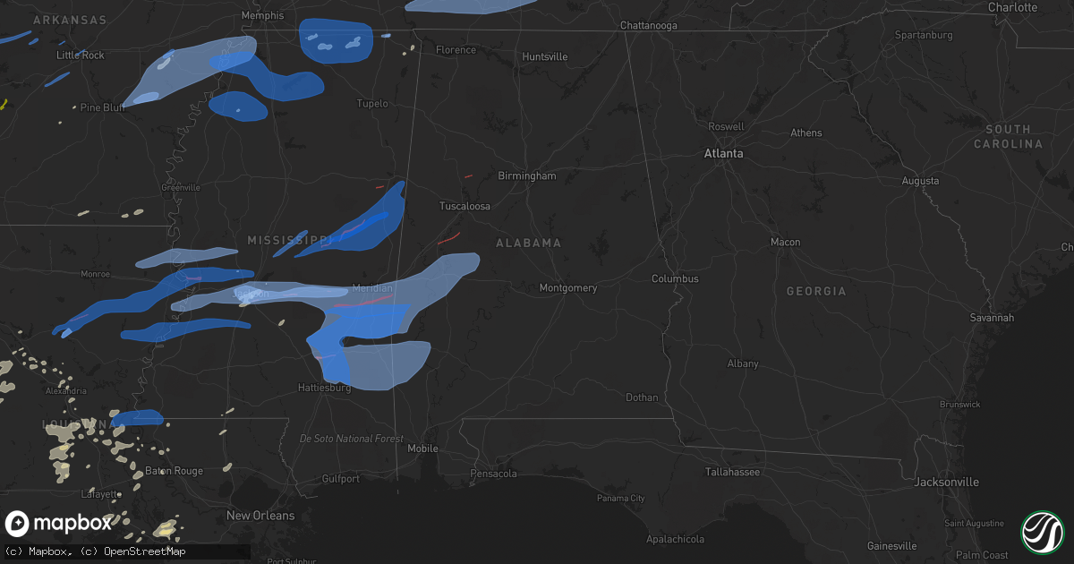
Hail Map in Alabama on April 13, 2022
Get this storm
April 13 map
$229
one time, instant access
Download today. No call, no setup
Keep the $229
Bought the map and want the full workflow? Apply the entire $229 to a subscription within 7 days. None of it is wasted.
Every map, not just this one
This buys you this map. Subscription and you get every map we run, in the markets you choose from a few cities to whole states to nationwide. Plus real-time alerts the moment a storm fires.
Contact data
Name, contact info, occupancy, even credit band for addresses in the footprint. You go from where it hit to who to call.
Become the source they trust
Unlimited branding weather history reports on demand. You already have the documented answer ready for the property owner, and you are the one who showed up with it.
Property data and RoofTrace estimates
Pull up any address you have got, its value and the exact code rules for that jurisdiction, straight from One Click Code. Then RoofTrace estimates the squares, pitch, and roof value, priced the way you price.
Storm reports in Alabama
Alabama
| Date | Description |
|---|---|
| 04/13/20226:25 AM CDT | At 1125 PM CDT, a severe thunderstorm was located near Wade, or 14 miles south of Lucedale, moving southeast at 45 mph. HAZARD...60 mph wind gusts. SOURCE...Radar indicated. IMPACT...Expect damage to roofs, siding, and trees. Locations impacted include... Hurley, Big Point, Wade and Vancleave. |
| 04/13/20226:23 AM CDT | At 1123 PM CDT, severe thunderstorms were located along a line extending from 12 miles southwest of Gordonville to 10 miles northwest of Georgiana to 12 miles north of Evergreen, moving east at 50 mph. HAZARD...60 mph wind gusts. SOURCE...Radar indicated. IMPACT...Expect damage to roofs, siding, and trees. Locations impacted include... Greenville, Luverne, Georgiana, Brantley, McKenzie, Rutledge, Dozier, Glenwood, Petrey and Highland Home. |
| 04/13/20226:08 AM CDT | At 1108 PM CDT, a severe thunderstorm was located near West Jefferson, or 9 miles south of Dora, moving east at 40 mph. HAZARD...60 mph wind gusts. SOURCE...Radar indicated. IMPACT...Expect damage to roofs, siding, and trees. Locations impacted include... Birmingham, Mountain Brook, Hueytown, Gardendale, Irondale, Fairfield, Fultondale, Sumiton, Dora, Pleasant Grove, Tarrant, Midfield, Adamsville, Warrior, Kimberly, Graysville, Morris, Sylvan Springs, Brookside and Mulga. |
| 04/13/20225:37 AM CDT | At 1036 PM CDT, severe thunderstorms were located along a line extending from 10 miles south of Central Mills to 9 miles east of Whatley to 3 miles west of McIntosh, moving east at 55 mph. HAZARD...60 mph wind gusts. SOURCE...Radar indicated. IMPACT...Expect damage to roofs, siding, and trees. Locations impacted include... Greenville, Monroeville, Evergreen, Camden, Frisco City, Peterman, Georgiana, Uriah, Excel, Beatrice, Vredenburgh, Repton, Yellow Bluff, Pine Apple and I65 And US 84. |
| 04/13/20225:34 AM CDT | At 1034 PM CDT, severe thunderstorms were located along a line extending from near Centreville to 6 miles north of Camden, moving east at 50 mph. HAZARD...60 mph wind gusts. SOURCE...Radar indicated. IMPACT...Expect damage to roofs, siding, and trees. Locations impacted include... Prattville, Millbrook, Calera, Clanton, Jemison, Fort Deposit, Mosses, Hayneville, Thorsby, Deatsville, Autaugaville, White Hall, Maplesville, Gordonville, Billingsley, Lowndesboro, Benton, Gap Of The Mountain, Parnell and Autauga County Airport. |
| 04/13/20225:29 AM CDT | At 1029 PM CDT, severe thunderstorms were located along a line extending from 6 miles north of Boley Springs to Binion Creek Landing, moving east at 40 mph. HAZARD...60 mph wind gusts. SOURCE...Radar indicated. IMPACT...Expect damage to roofs, siding, and trees. Locations impacted include... Hueytown, Sumiton, Cordova, Dora, Pleasant Grove, Adamsville, Graysville, Sylvan Springs, Berry, Parrish, Oakman, Maytown, West Jefferson, North Johns, Gorgas Steam Plant, Bull City, Samantha, Gorgas, Boley Springs and Concord. |
| 04/13/20225:12 AM CDT | At 1012 PM CDT, severe thunderstorms were located along a line extending from 7 miles northeast of Newbern to near Uniontown to Shawnee, moving east at 65 mph. HAZARD...70 mph wind gusts and penny size hail. SOURCE...Radar indicated. IMPACT...Expect considerable tree damage. Damage is likely to mobile homes, roofs, and outbuildings. Locations impacted include... Selma, Valley Grande, Selmont-West Selmont, Orrville, Bogue Chitto, Gardner Island, Tyler, Central Mills, Old Cahaba Park, Dannelly Reservoir, Dallas County Horse Arena, Belknap, Paul M Grist State Park, Dallas Lake, Memorial Stadium, Marion Junction, Burnsville, Potter Station, Carlowville and Safford. |
| 04/13/20224:59 AM CDT | At 959 PM CDT, severe thunderstorms were located along a line extending from near Shelton State Community College to near Greensboro to Chickasaw State Park, moving east at 55 mph. HAZARD...70 mph wind gusts and penny size hail. SOURCE...Radar indicated. IMPACT...Expect considerable tree damage. Damage is likely to mobile homes, roofs, and outbuildings. Locations impacted include... Brent, Marion, Centreville, Uniontown, Vance, West Blocton, Newbern, Vaiden, West Centreville, Heiberger, Lawley, Ashby, Brierfield Ironworks Park, Low Gap, Mertz, Talladega National Forest, Eoline, North Bibb, Randolph and Radford. |
| 04/13/20224:47 AM CDT | At 946 PM CDT, severe thunderstorms were located along a line extending from near Haleyville to near Millport, moving east at 45 mph. HAZARD...60 mph wind gusts. SOURCE...Radar indicated. IMPACT...Expect damage to roofs, siding, and trees. Locations impacted include... Winfield, Fayette, Haleyville, Carbon Hill, Millport, Lynn, Guin, Berry, Double Springs, Brilliant, Glen Allen, Kennedy, Kansas, Nauvoo, Belk, Gu- Win, Eldridge, Houston Recreational Area, Ashbank and Ashridge. |
| 04/13/20224:39 AM CDT | At 939 PM CDT, severe thunderstorms were located along a line extending from 7 miles northwest of Pennington to near Butler, moving east at 50 mph. HAZARD...70 mph wind gusts and penny size hail. SOURCE...Radar indicated. IMPACT...Expect considerable tree damage. Damage is likely to mobile homes, roofs, and outbuildings. Locations impacted include... Linden, Thomaston, Sweet Water, Myrtlewood, Putnam, Freddie Jones Field, Nanafalia, Consul, Magnolia, Wayne, Surginer, Miller, Dixons Mill, Vineland, Half Acre, Carleys, Octagon, Clayhill, Nicholsville and Calvary. |
| 04/13/20224:33 AM CDT | At 933 PM CDT, severe thunderstorms were located along a line extending from near Ethelsville to near Union to near Kinterbish, moving east at 55 mph. HAZARD...70 mph wind gusts and penny size hail. SOURCE...Radar indicated. IMPACT...Expect considerable tree damage. Damage is likely to mobile homes, roofs, and outbuildings. Locations impacted include... Tuscaloosa, Northport, Demopolis, Eutaw, Greensboro, Linden, Gordo, Reform, Carrollton, Holt, Jefferson, Moundville, Brookwood, Coaling, Vance, Coker, Forkland, Akron, Boligee and Union. |
| 04/13/20223:55 AM CDT | At 855 PM CDT, a severe thunderstorm was located 7 miles southeast of Amory, moving northeast at 35 mph. HAZARD...60 mph wind gusts. SOURCE...Radar indicated. IMPACT...Expect damage to roofs, siding, and trees. Locations impacted include... Amory, Aberdeen, Smithville, Hatley, Gattman, Binford, Sipsey Fork, New Hamilton, Becker, Quincy, Splunge, Wise Gap, Athens, East Aberdeen, Greenwood Springs and Parham. |
| 04/13/20223:54 AM CDT | At 854 PM CDT, severe thunderstorms were located along a line extending from near Barnett to near Sandersville, moving east at 60 mph. HAZARD...70 mph wind gusts. SOURCE...Radar indicated. IMPACT...Expect considerable tree damage. Damage is likely to mobile homes, roofs, and outbuildings. Severe thunderstorms will be near... Barnett around 900 PM CDT. De Soto around 905 PM CDT. Goodwater around 910 PM CDT. Crandall around 915 PM CDT.Other locations impacted by these severe thunderstorms includeShubuta. |
| 04/13/20223:52 AM CDT | At 850 PM CDT, severe thunderstorms were located along a line extending from 7 miles west of Meehan to near Moss to 3 miles north of Improve, moving east at 60 mph. HAZARD...70 mph wind gusts and penny size hail. SOURCE...Radar indicated. IMPACT...Expect considerable tree damage. Damage is likely to mobile homes, roofs, and outbuildings. Locations impacted include... Waynesboro, Butler, Chatom, Richton, Clara, Lisman, Millry, State Line, Buckatunna, Silas, Fruitdale, Pennington, Gilbertown and Toxey. |
| 04/13/20223:46 AM CDT | At 845 PM CDT, severe thunderstorms were located along a line extending from 6 miles south of Oktoc to near Macon to 8 miles northeast of De Kalb to Meridian, moving east at 70 mph. HAZARD...60 mph wind gusts and penny size hail. SOURCE...Radar indicated. IMPACT...Expect damage to roofs, siding, and trees. Locations impacted include... Demopolis, Livingston, Eutaw, York, Aliceville, Gordo, Reform, Carrollton, Pickensville, Cuba, Forkland, Boligee, Union, Gainesville, Epes, Ethelsville, Emelle, McMullen, Panola and West Greene. |
| 04/13/20223:24 AM CDT | At 824 PM CDT, severe thunderstorms were located along a line extending from near Prospect to near Pineville, moving east at 60 mph. HAZARD...70 mph wind gusts. SOURCE...Radar indicated. IMPACT...Expect considerable tree damage. Damage is likely to mobile homes, roofs, and outbuildings. Severe thunderstorms will be near... Roberts and Dixon around 830 PM CDT. Neshoba and Stratton around 835 PM CDT. Bethsaida and Little Rock around 840 PM CDT. Herbert Springs and House around 845 PM CDT. Martin around 850 PM CDT. Liberty and Damascus around 855 PM CDT. Prismatic, Blackwater, Daleville and Savoy around 900 PM CDT. Meridian Station around 905 PM CDT.Other locations impacted by these severe thunderstorms includeTucker, Chunky and Hickory. |
| 04/13/20222:54 AM CDT | At 753 PM CDT, severe thunderstorms were located along a line extending from 7 miles east of Spring Hill to 13 miles east of Lexington, moving east at 60 mph. HAZARD...70 mph wind gusts. SOURCE...Radar indicated. IMPACT...Expect considerable tree damage. Damage is likely to mobile homes, roofs, and outbuildings. Locations impacted include... Columbia, Shelbyville, Lewisburg, Manchester, Pulaski, Spring Hill, Tullahoma, Chapel Hill, Ardmore, Cornersville, Wartrace, Eagleville, Elkton, Minor Hill, Bell Buckle, Lynnville, Normandy, Culleoka, Beechgrove and Raus.This includes the following highways... Interstate 65 between mile markers 1 and 54. Interstate 24 between mile markers 87 and 111. |
| 04/13/20222:52 AM CDT | At 751 PM CDT, severe thunderstorms were located along a line extending from 15 miles southwest of Lewisburg to near Pulaski to 12 miles northeast of Lexington to near Rogersville, moving east at 60 mph. HAZARD...70 mph wind gusts. SOURCE...Radar indicated. IMPACT...Expect considerable tree damage. Damage is likely to mobile homes, roofs, and outbuildings. Locations impacted include... Fayetteville, Lynchburg, Ardmore, Petersburg, Tims Ford Lake, Lincoln, Howell, Elora, Hurdlow and Mimosa. |
| 04/13/20222:19 AM CDT | At 718 PM CDT, severe thunderstorms were located along a line extending from 9 miles southeast of Centerville to 9 miles west of Loretto, moving east at 65 mph. HAZARD...70 mph wind gusts. SOURCE...Radar indicated. IMPACT...Expect considerable tree damage. Damage is likely to mobile homes, roofs, and outbuildings. Locations impacted include... Columbia, Lewisburg, Lawrenceburg, Pulaski, Spring Hill, Mount Pleasant, Loretto, Summertown, Chapel Hill, Ardmore, Cornersville, St. Joseph, Elkton, Minor Hill, Ethridge, Lynnville, Gordonsburg, Henryville, Culleoka and Goodspring.This includes Interstate 65 between mile markers 1 and 51. |
| 04/12/202211:30 PM CDT | Tree down on vickery rd. |
| 04/12/202211:25 PM CDT | Tree down and debris on south shackelford rd. |
| 04/12/202211:10 PM CDT | Trees down on highway 29 and old federal road. |
| 04/12/202211:07 PM CDT | Power lines were blown down and caught trees on fire near birmingport. |
| 04/12/202211:03 PM CDT | Tds detected by radar. Mostly likely tornado. |
| 04/12/202211:02 PM CDT | Trees down on highway 21. |
| 04/12/202210:58 PM CDT | Trees down near franklin ferry rd and camp oliver rd. |
| 04/12/202210:56 PM CDT | Trees down with multiple homes damaged. |
| 04/12/202210:55 PM CDT | Multiple trees down with some causing structural damage in the smith camp area along the black warrior river...including along smith camp rd and smith camp loop. |
| 04/12/202210:55 PM CDT | Canopy blown off of boat slips and minor pier damage at franklin ferry marina. Minor loss of siding at the cafe. |
| 04/12/202210:49 PM CDT | Trees down on hwy 82. One fell on a motorists vehicle while traveling. |
| 04/12/202210:37 PM CDT | A few trees were blown down around orrville. |
| 04/12/202210:34 PM CDT | Some trees blown down on n scottsville rd. |
| 04/12/202210:30 PM CDT | Tree down on oregonia road. |
| 04/12/202210:25 PM CDT | Multiple trees and power lines down on 32nd street. |
| 04/12/202210:21 PM CDT | Numerous trees down... Some covering roadways. Most are northeast of marion. |
| 04/12/202210:20 PM CDT | Trees were blown down on mobile homes on flatwoods road. |
| 04/12/202210:13 PM CDT | Tds was detected on kbmx radar. Most likely tornado. |
| 04/12/202210:11 PM CDT | Trees down about 1/2 mile north of sr 25 and sr 28 intersection. |
| 04/12/202210:08 PM CDT | A tree down on powerlines along county rd 3014. |
| 04/12/202210:08 PM CDT | Trees down 3 blocks west of sr 28 and sr 25. |
| 04/12/202210:05 PM CDT | Corrects previous tstm wnd dmg report from 1 ese flatwoods. Multiple trees and power lines down on 32nd street. |
| 04/12/202210:05 PM CDT | Corrects previous tstm wnd dmg report from 1 e flatwoods. Trees down with multiple homes damaged. |
| 04/12/202210:04 PM CDT | Several trees and power lines were blown down. A fire started due to the power lines being down. Most of the trees are down near cr 44 and cr 50. |
| 04/12/202210:00 PM CDT | Multiple trees were blown down on the east side of linden. |
| 04/12/202210:00 PM CDT | Tree on a home near brooks drive and grace circle. |
| 04/12/20229:58 PM CDT | Two large trees were blown down and blocked the roadway. Two vehicles ran into the fallen trees and totaled the vehicles. No injuries were reported. |
| 04/12/20229:55 PM CDT | Trees were sporadically blown down across the southern part of hale county. |
| 04/12/20229:52 PM CDT | Trees blocking road near highway 69 and ulcanush lane. |
| 04/12/20229:52 PM CDT | Multiple trees down on cedarwood road near havana junction. |
| 04/12/20229:47 PM CDT | Numerous trees were blown down along cr 42 between akron and stewart. The road is completely blocked. |
| 04/12/20229:36 PM CDT | Trees down along highway 84 and areas to the north. |
| 04/12/20229:35 PM CDT | Scattered trees down in areas north of butler... And 12.6 percent of customers throughout the county without power. |
| 04/12/20229:35 PM CDT | Trees were blown down in union. |
| 04/12/20229:32 PM CDT | Scattered trees and powerlines down. |
| 04/12/20229:31 PM CDT | Multiple trees were blown down in the branch heights community. One person is trapped... Apartments have roof damage and vehicles were moved. |
| 04/12/20229:30 PM CDT | Trees blown down on sr 39. |
| 04/12/20229:23 PM CDT | Tree was blown down and blocking the roadway at us 11 and sr 39. |
| 04/12/20229:18 PM CDT | Tree blown down near us 11 and us 80. |
| 04/12/20228:55 PM CDT | Corrects previous tstm wnd dmg report from 4 ne huntsville. Trees and powerlines down near the five points area. |
| 04/12/20228:19 PM CDT | Tree on house on thach rd. Time estimated from radar and report received from social media. |
| 04/12/20227:15 PM CDT | Tree down on power line on white pike rd. Es downed across the county... With several roads blocked. One tree fell on a home on hwy 184 e an |
| 04/12/20227:15 PM CDT | Tree down on power line on white pike rd. |
| 04/12/20227:12 PM CDT | Tree down on north pike. |
| 04/12/20227:09 PM CDT | Tree down on riverton rose trail. Time estimated from radar. |
All States Impacted by Hail Map on April 13, 2022
Cities Impacted by Hail Map on April 13, 2022
- Kemp, TX
- Kaufman, TX
- Malakoff, TX
- Athens, TX
- Eustace, TX
- Mabank, TX
- Cedar Hill, TX
- Joaquin, TX
- Mansfield, LA
- Center, TX
- Shelbyville, TX
- Williams, IN
- Shoals, IN
- Saint Landry, LA
- Mount Vernon, TX
- Eunice, LA
- Basile, LA
- Dustin, OK
- Henryetta, OK
- Weleetka, OK
- Hanna, OK
- Eufaula, OK
- Flowood, MS
- Park Hill, OK
- Lamar, MS
- Holly Springs, MS
- Cecilia, KY
- Corsicana, TX
- Palestine, TX
- Larue, TX
- Oakdale, LA
- Keene, TX
- Cleburne, TX
- Lone Oak, TX
- Sulphur Springs, TX
- Yantis, TX
- Emory, TX
- Mendenhall, MS
- Many, LA
- Robeline, LA
- Lancaster, TX
- Red Oak, TX
- Ferris, TX
- White Plains, KY
- Nortonville, KY
- Cumby, TX
- Klondike, TX
- Greenville, TX
- Wolfe City, TX
- Commerce, TX
- Farmersville, TX
- Campbell, TX
- Brashear, TX
- Celeste, TX
- Caddo Mills, TX
- Morgan City, LA
- Pierre Part, LA
- Princeton, TX
- Kerens, TX
- Oberlin, LA
- Ville Platte, LA
- Mamou, LA
- Glenmora, LA
- Frost, TX
- Blooming Grove, TX
- Barry, TX
- Osyka, MS
- Horse Branch, KY
- Caneyville, KY
- Melville, LA
- Morganza, LA
- Palmetto, LA
- Port Barre, LA
- Royse City, TX
- Henderson, TN
- Falkner, MS
- Tiplersville, MS
- Ripley, MS
- Walnut, MS
- Hudson, KY
- Zachary, LA
- Dierks, AR
- Dodd City, TX
- Bonham, TX
- Waxahachie, TX
- Saint Martinville, LA
- Red Banks, MS
- Maringouin, LA
- Lottie, LA
- Franklin, LA
- Noble, LA
- Converse, LA
- Palmer, TX
- Ennis, TX
- Brinkley, AR
- Pineville, LA
- Alexandria, LA
- Berwick, LA
- Campti, LA
- Ventress, LA
- Hamburg, AR
- Bethel Springs, TN
- Finger, TN
- Natchez, LA
- Natchitoches, LA
- Quinlan, TX
- Rineyville, KY
- Elizabethtown, KY
- Vine Grove, KY
- Highlandville, MO
- Alvarado, TX
- San Augustine, TX
- Nacogdoches, TX
- Murchison, TX
- Trinidad, TX
- Rice, TX
- Jackson, MS
- Richland, MS
- New Roads, LA
- New Iberia, LA
- Iuka, MS
- Napoleonville, LA
- Grosse Tete, LA
- Garfield, KY
- Eastview, KY
- Leitchfield, KY
- Big Clifty, KY
- Custer, KY
- Saltillo, TX
- Leonard, TX
- Oakhurst, TX
- Coldspring, TX
- Jeanerette, LA
- Welling, OK
- Midlothian, TX
- Venus, TX
- Tennessee Colony, TX
- Cloutierville, LA
- Delcambre, LA
- Erath, LA
- Portland, AR
- Parkdale, AR
- Cookson, OK
- Tahlequah, OK
- Ladonia, TX
- Sunnyvale, TX
- Blue Ridge, TX
- Pecan Gap, TX
- Trenton, TX
- Bailey, TX
- Rockwall, TX
- Mckinney, TX
- Melissa, TX
- Anna, TX
- Mesquite, TX
- Nevada, TX
- Cooper, TX
- Evergreen, LA
- Morrow, LA
- Saint Francisville, LA
- Windom, TX
- Brandon, MS
- Broussard, LA
- Rosser, TX
- Wilmer, TX
- Chatfield, TX
- Scurry, TX
- Bunkie, LA
- Farmington, MO
- Fredericktown, MO
- Cottonport, LA
- Opelousas, LA
- Iredell, TX
- Huntsville, TX
- Batchelor, LA
- Reagan, TN
- Lexington, TN
- Carthage, AR
- Port Allen, LA
- Pearl, MS
- Washington, LA
- Sunrise Beach, MO
- Camdenton, MO
- Bedford, IN
- Hornbeck, LA
- Leesville, LA
- Anacoco, LA
- Cromwell, KY
- Flora, MS
- Montalba, TX
- Frankston, TX
- Krotz Springs, LA
- Honey Grove, TX
- Morgan, TX
- Walnut Springs, TX
- Meridian, TX
- Hico, TX
- Joshua, TX
- Godley, TX
- Duson, LA
- Scott, LA
- McDaniels, KY
- Falls Of Rough, KY
- Colfax, LA
- Lecompte, LA
- Forest Hill, LA
- Stilwell, OK
- Lambert, MS
- Florien, LA
- Iota, LA
- Moreauville, LA
- Provencal, LA
- Kentwood, LA
- Greensburg, LA
- Bentley, LA
- Dry Prong, LA
- Pollock, LA
- Ball, LA
- Clarendon, AR
- Holly Grove, AR
- Roe, AR
- Grapevine, AR
- Milam, TX
- Council Hill, OK
- Lena, LA
- Patterson, LA
- Gibson, LA
- Lettsworth, LA
- Simmesport, LA
- Ponchatoula, LA
- Hammond, LA
- Blossom, TX
- Strong, AR
- Erwinville, LA
- Glynn, LA
- Terry, MS
- Raymond, MS
- Byram, MS
- Glen Rose, TX
- Magnolia, MS
- Ashland, MS
- Montgomery, LA
- Church Point, LA
- Plaucheville, LA
- Morgantown, KY
- Pinson, TN
- Mitchell, IN
- Norman, IN
- Heltonville, IN
- Freetown, IN
- Medora, IN
- Brownstown, IN
- Seymour, IN
- Perryville, AR
- Plainview, AR
- Marshall, AR
- Norfork, AR
- Harriet, AR
- Calico Rock, AR
- Hope, AR
- Emmet, AR
- Prescott, AR
- Fulton, AR
- Benton, AR
- Traskwood, AR
- Bauxite, AR
- Alexander, AR
- Roland, AR
- Little Rock, AR
- North Little Rock, AR
- Osceola, AR
- Marked Tree, AR
- Cherry Valley, AR
- Lepanto, AR
- Etowah, AR
- Steele, MO
- Caruthersville, MO
- Hayti, MO
- Monette, AR
- Brookland, AR
- Hornersville, MO
- Leachville, AR
- Lake City, AR
- Jonesboro, AR
- Lake Cormorant, MS
- Casscoe, AR
- De Valls Bluff, AR
- Almyra, AR
- Coldwater, MS
- Hughes, AR
- West Helena, AR
- Crocketts Bluff, AR
- Walls, MS
- Poplar Grove, AR
- Tunica, MS
- Robinsonville, MS
- Marvell, AR
- Wabbaseka, AR
- De Witt, AR
- Altheimer, AR
- Brickeys, AR
- Humphrey, AR
- Marianna, AR
- Lexa, AR
- Helena, AR
- Moro, AR
- Hernando, MS
- Saint Charles, AR
- Dundee, MS
- Stuttgart, AR
- Aubrey, AR
- Brownsville, TN
- Bells, TN
- Stanton, TN
- Silver Point, TN
- Mount Juliet, TN
- Milton, TN
- Burns, TN
- Brentwood, TN
- Pegram, TN
- Dickson, TN
- Clarkrange, TN
- Gainesboro, TN
- La Vergne, TN
- Allred, TN
- Chestnut Mound, TN
- Kingston Springs, TN
- Smyrna, TN
- Pleasant Shade, TN
- Bloomington Springs, TN
- Hickman, TN
- Livingston, TN
- Antioch, TN
- Hermitage, TN
- Rickman, TN
- Gordonsville, TN
- Waverly, TN
- Alexandria, TN
- Nashville, TN
- Cookeville, TN
- Only, TN
- Fairview, TN
- Bon Aqua, TN
- Brush Creek, TN
- New Johnsonville, TN
- Liberty, TN
- Hurricane Mills, TN
- Alpine, TN
- Carthage, TN
- Buffalo Valley, TN
- Lascassas, TN
- Celina, TN
- Monroe, TN
- Wilder, TN
- Dowelltown, TN
- Watertown, TN
- Monterey, TN
- Franklin, TN
- Baxter, TN
- Nunnelly, TN
- Riddleton, TN
- Crawford, TN
- Lancaster, TN
- White Bluff, TN
- Lyles, TN
- Centerville, TN
- Whitleyville, TN
- Murfreesboro, TN
- Duck River, TN
- Smithville, TN
- Elmwood, TN
- McEwen, TN
- Primm Springs, TN
- Granville, TN
- Hilham, TN
- Lebanon, TN
- Charlotte, TN
- Olivehill, TN
- Mount Pleasant, TN
- Clifton, TN
- Savannah, TN
- Adamsville, TN
- Westpoint, TN
- Waynesboro, TN
- Lutts, TN
- Shelbyville, TN
- Columbia, TN
- Leoma, TN
- Belfast, TN
- Pulaski, TN
- Loretto, TN
- Lynnville, TN
- Petersburg, TN
- Cornersville, TN
- Culleoka, TN
- Summertown, TN
- Ethridge, TN
- Collinwood, TN
- Hohenwald, TN
- Lewisburg, TN
- Lawrenceburg, TN
- Crump, TN
- Walling, TN
- Crossville, TN
- Evensville, TN
- Rock Island, TN
- Mcminnville, TN
- Pikeville, TN
- Sparta, TN
- Spencer, TN
- Quebeck, TN
- Doyle, TN
- Dayton, TN
- Spring City, TN
- Woodbury, TN
- Grandview, TN
- Springville, IN
- Waterford, MS
- Sardis, MS
- Como, MS
- Abbeville, MS
- Oxford, MS
- University, MS
- Crenshaw, MS
- Potts Camp, MS
- Taylor, MS
- Sarah, MS
- Senatobia, MS
- Batesville, MS
- Thaxton, MS
- Pope, MS
- Enid, MS
- Lyon, MS
- Clarksdale, MS
- Oakland, MS
- Coahoma, MS
- Courtland, MS
- Sledge, MS
- Marks, MS
- Vance, MS
- Byhalia, MS
- Pocahontas, TN
- Moscow, TN
- La Grange, TN
- Rienzi, MS
- Rossville, TN
- Hickory Valley, TN
- Middleton, TN
- Williston, TN
- Hickory Flat, MS
- Grand Junction, TN
- Collierville, TN
- Michigan City, MS
- Corinth, MS
- Blue Mountain, MS
- Saulsbury, TN
- Sawyerville, AL
- Faunsdale, AL
- Raleigh, MS
- Bolton, MS
- Quitman, MS
- Florence, MS
- Lake, MS
- Bay Springs, MS
- Edwards, MS
- Petal, MS
- Seminary, MS
- Livingston, AL
- Demopolis, AL
- Pachuta, MS
- Vossburg, MS
- Gilbertown, AL
- Forkland, AL
- Ridgeland, MS
- Uniontown, AL
- Silas, AL
- Soso, MS
- Tougaloo, MS
- Richton, MS
- Conehatta, MS
- Cuba, AL
- Chatom, AL
- Needham, AL
- Utica, MS
- Mize, MS
- Sweet Water, AL
- Clinton, MS
- Moselle, MS
- Pulaski, MS
- Bellamy, AL
- Stonewall, MS
- Fruitdale, AL
- Lawrence, MS
- Thomasville, AL
- Waynesboro, MS
- Enterprise, MS
- Tallulah, LA
- Toomsuba, MS
- Deer Park, AL
- Millry, AL
- Greensboro, AL
- Laurel, MS
- Stringer, MS
- Shubuta, MS
- York, AL
- Ellisville, MS
- Boligee, AL
- Chunky, MS
- Meridian, MS
- Louin, MS
- Toxey, AL
- Decatur, MS
- Newbern, AL
- Ovett, MS
- Lisman, AL
- Saint Stephens, AL
- Hickory, MS
- State Line, MS
- Ward, AL
- Coffeeville, AL
- Morton, MS
- Buckatunna, MS
- Vicksburg, MS
- Pelahatchie, MS
- Butler, AL
- Forest, MS
- Collins, MS
- Rose Hill, MS
- Heidelberg, MS
- Marion, AL
- Melvin, AL
- Linden, AL
- Paulding, MS
- Newellton, LA
- Newton, MS
- Taylorsville, MS
- Gallion, AL
- Jachin, AL
- Frankville, AL
- Jackson, AL
- Pennington, AL
- Camden, MS
- Canton, MS
- Kosciusko, MS
- Carthage, MS
- Columbus, MS
- Scooba, MS
- Brooksville, MS
- Philadelphia, MS
- Shuqualak, MS
- Noxapater, MS
- Crawford, MS
- Louisville, MS
- Macon, MS
- Preston, MS
- De Kalb, MS
- Monterey, LA
- Woodville, MS
- Angola, LA
- Grayson, LA
- Louisville, KY
- Greensburg, IN
- Redwood, MS
- Berry, AL
- Eutaw, AL
- Akron, AL
- Moundville, AL
- Water Valley, KY
- Mayfield, KY
- Benton, KY
- Eddyville, KY
- Cadiz, KY
- Upton, KY
- Buffalo, KY
- Hodgenville, KY
- Mount Sherman, KY
- Taylorsville, KY
- Shelbyville, KY
- Waddy, KY
- Westport, IN
- Troy, TN
- Obion, TN
- Hickman, KY
- Hornbeak, TN
- Union City, TN
- Fulton, KY
- Wingo, KY
- Gilbertsville, KY
- Kirksey, KY
- Kuttawa, KY
- South Fulton, TN
- Rockport, KY
- Cub Run, KY
- Mammoth Cave, KY
- Drakesboro, KY
- Brownsville, KY
- Greenville, KY
- Clarkson, KY
- Graham, KY
- Beaver Dam, KY
- Powderly, KY
- Sweeden, KY
- Central City, KY
- Bee Spring, KY
- Roundhill, KY
- Sharon Grove, KY
- Lewisburg, KY
- Olmstead, KY
- Orlinda, TN
- Elkton, KY
- Trenton, KY
- Franklin, KY
- Springfield, TN
- Russellville, KY
- Oak Grove, KY
- Allensville, KY
- Gracey, KY
- Pembroke, KY
- Auburn, KY
- Adairville, KY
- Hopkinsville, KY
- Guthrie, KY
- Fordsville, KY
- Hartford, KY
- Dover, KY
- Russellville, OH
- Richmond, KY
- Bagdad, KY
- Aberdeen, OH
- Nicholasville, KY
- Harned, KY
- Brooks, KY
- West Union, OH
- Brandenburg, KY
- Maysville, KY
- Germantown, KY
- Chaplin, KY
- Frankfort, KY
- Stamping Ground, KY
- Mount Washington, KY
- Berry, KY
- Clermont, KY
- West Point, KY
- Lebanon Junction, KY
- Georgetown, KY
- Webster, KY
- Guston, KY
- Ewing, KY
- Lexington, KY
- Shepherdsville, KY
- Brooksville, KY
- Finchville, KY
- Simpsonville, KY
- Fairfield, KY
- Wilmore, KY
- Ekron, KY
- Mayslick, KY
- Millersburg, KY
- Paris, KY
- Falmouth, KY
- Lawrenceburg, KY
- Mount Eden, KY
- Elizabeth, IN
- Midway, KY
- Bardstown, KY
- Laconia, IN
- Manchester, OH
- Muldraugh, KY
- Irvington, KY
- Versailles, KY
- Bloomfield, KY
- Georgetown, OH
- Fisherville, KY
- Carlisle, KY
- Ripley, OH
- Fairdale, KY
- Winchester, KY
- Hardinsburg, KY
- Mount Olivet, KY
- Augusta, KY
- Salvisa, KY
- Coxs Creek, KY
- Cynthiana, KY
- Stanford, KY
- Danville, KY
- Crab Orchard, KY
- Irvine, KY
- Paint Lick, KY
- Lancaster, KY
- Berea, KY
- Waco, KY
- Greensburg, KY
- Canmer, KY
- Summersville, KY
- Magnolia, KY
- Campbellsville, KY
- Clinton, KY
- Sonora, KY
- Duncanville, TX
- Desoto, TX
- Dallas, TX
- Delight, AR
- Okolona, AR
- Antoine, AR
- Bismarck, AR
- Story, AR
- Mount Ida, AR
- Sims, AR
- Cookville, TX
- Leesburg, TX
- Scroggins, TX
- Pittsburg, TX
- Mount Pleasant, TX
- Omaha, TX
- Avery, TX
- Annona, TX
- New Boston, TX
- Foreman, AR
- De Kalb, TX
- Valley Park, MS
- Columbia, LA
- Winnfield, LA
- Winnsboro, LA
- Delhi, LA
- Sondheimer, LA
- Madison, MS
- Bentonia, MS
- Mangham, LA
- Sikes, LA
- Rayville, LA
- Satartia, MS
- Baskin, LA
- Olla, LA
- Tullos, LA
- Kelly, LA
- Epps, LA
- Yazoo City, MS
- Pioneer, LA
- Mayersville, MS
- Rolling Fork, MS
- Lake Providence, LA
- Transylvania, LA
- Tinsley, MS
- Cary, MS
- Hazlehurst, MS
- Lorman, MS
- Hermanville, MS
- Clayton, LA
- Waterproof, LA
- Saint Joseph, LA
- Port Gibson, MS
- Gilbert, LA
- Sicily Island, LA
- Wisner, LA
- Crystal Springs, MS


