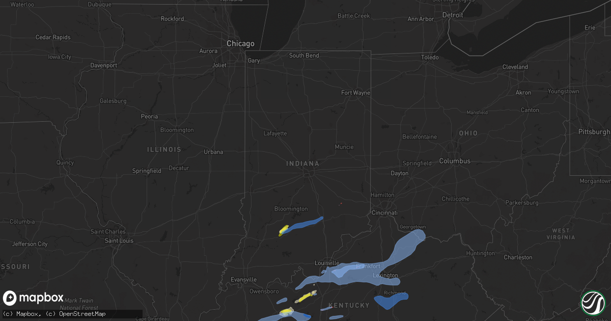
Hail Map in Indiana on April 13, 2022
Get this storm
April 13 map
$229
one time, instant access
Download today. No call, no setup
Keep the $229
Bought the map and want the full workflow? Apply the entire $229 to a subscription within 7 days. None of it is wasted.
Every map, not just this one
This buys you this map. Subscription and you get every map we run, in the markets you choose from a few cities to whole states to nationwide. Plus real-time alerts the moment a storm fires.
Contact data
Name, contact info, occupancy, even credit band for addresses in the footprint. You go from where it hit to who to call.
Become the source they trust
Unlimited branding weather history reports on demand. You already have the documented answer ready for the property owner, and you are the one who showed up with it.
Property data and RoofTrace estimates
Pull up any address you have got, its value and the exact code rules for that jurisdiction, straight from One Click Code. Then RoofTrace estimates the squares, pitch, and roof value, priced the way you price.
Storm reports in Indiana
Indiana
| Date | Description |
|---|---|
| 04/13/20226:55 PM CDT | Late report of estimated 70 mph winds pushing a mobile home off its foundation at 2515 buckingham drive. Nearby trees fell into homes at both 171 country squire bouleva |
| 04/13/20226:40 PM CDT | Late report of isolated downed trees on salt creek road and valley branch road and railroad road. Time estimated from radar. |
| 04/13/20226:25 PM CDT | Late report of multiple trees down along indiana state route 258 from freetown to courtland. Some trees fell into power lines. Time estimated from radar. |
| 04/13/20226:25 PM CDT | Late report of multiple trees down along indiana state route 258 from freetown to courtland. Some trees fell 60-70 mph. |
| 04/13/20226:12 PM CDT | Estimated 80 mph straight line winds caused major structural damage to the large western portion of the boat docks and awning near the northeast portion of the indiana |
| 04/13/20226:12 PM CDT | Late report of rural king facade damaged. Estimated 65 mph wind. Time estimated by radar. |
| 04/13/20225:40 PM CDT | Late report of a few trees downed around shoals. Time estimated by radar. |
| 04/13/20225:38 PM CDT | Trees down north of dubois near intersection of state highway 56 and 545. |
| 04/13/20225:35 PM CDT | Late report of large tree falling onto terre haute humane society causing significant damage. No injuries and 20 displaced dogs were all uninjured. Time estimated from |
| 04/13/20223:11 AM CDT | At 811 PM EDT, a severe thunderstorm was located over Hollyvilla, moving northeast at 70 mph. HAZARD...70 mph wind gusts and quarter size hail. SOURCE...Radar indicated. IMPACT...Hail damage to vehicles is expected. Expect considerable tree damage. Wind damage is also likely to mobile homes, roofs, and outbuildings. This severe thunderstorm will be near... Audubon Park, Lynnview, Okolona and Newburg around 815 PM EDT. St. Regis Park, West Buechel, Watterson Park, Hollow Creek, Seneca Gardens, Strathmoor Village, Houston Acres, Norbourne Estates, Kingsley and Meadowview Estates around 820 PM EDT. Jeffersontown, Lyndon, Middletown, Douglass Hills, Hurstbourne, Anchorage, Hurstbourne Acres, Beechwood Village, Rolling Hills and Langdon Place around 825 PM EDT. Worthington Hills around 830 PM EDT. |
| 04/13/20223:06 AM CDT | At 806 PM EDT, a severe thunderstorm was located 8 miles northeast of North Vernon, moving northeast at 55 mph. HAZARD...60 mph wind gusts. SOURCE...Radar indicated. IMPACT...Expect damage to trees and power lines. Locations impacted include... Batesville, Versailles, Milan, Osgood, Oldenburg, Lake Santee, Sunman, Metamora, Laurel, Holton, Napoleon, Millhousen, Rexville, Huntersville, Hamburg, Penntown, Friendship, Peppertown, Versailles Lake and Buena Vista.This includes I-74 in Indiana between mile markers 145 and 157. |
| 04/13/20222:54 AM CDT | At 753 PM EDT, a severe thunderstorm was located near North Vernon, or 13 miles northeast of Seymour, moving northeast at 45 mph. HAZARD...70 mph wind gusts. SOURCE...Radar indicated. IMPACT...Expect considerable tree damage. Damage is likely to mobile homes, roofs, and outbuildings. This severe thunderstorm will be near... Westport and Butlerville around 805 PM EDT. Letts and Nebraska around 810 PM EDT.Other locations in the path of this severe thunderstorm includeMillhousen and Newpoint.This includes Interstate 74 between mile markers 128 and 144. |
| 04/13/20222:48 AM CDT | At 747 PM EDT, a severe thunderstorm was located over Brandenburg, moving east at 50 mph. HAZARD...70 mph wind gusts and penny size hail. SOURCE...Radar indicated. IMPACT...Expect considerable tree damage. Damage is likely to mobile homes, roofs, and outbuildings. Locations impacted include... Shepherdsville, Valley Station, Pleasure Ridge Par and St. Dennis. |
| 04/13/20222:17 AM CDT | At 716 PM EDT, a severe thunderstorm was located 12 miles northwest of Brownstown, or 17 miles west of Seymour, moving northeast at 45 mph. HAZARD...70 mph wind gusts and nickel size hail. SOURCE...Radar indicated. IMPACT...Expect considerable tree damage. Damage is likely to mobile homes, roofs, and outbuildings. This severe thunderstorm will be near... Story around 720 PM EDT. Spurgeons Corner and Stone Head around 725 PM EDT. Waymansville and Gnaw Bone around 730 PM EDT.Other locations in the path of this severe thunderstorm includeAzalia, Elizabethtown, Columbus, Clifford, Taylorsville and Newbern.This includes Interstate 65 between mile markers 37 and 94. |
| 04/13/20221:40 AM CDT | At 640 PM EDT, a severe thunderstorm was located 10 miles northeast of Shoals, or 11 miles southwest of Bedford, moving northeast at 45 mph. HAZARD...70 mph wind gusts and quarter size hail. SOURCE...Radar indicated. IMPACT...Hail damage to vehicles is expected. Expect considerable tree damage. Wind damage is also likely to mobile homes, roofs, and outbuildings. This severe thunderstorm will be near... Mitchell, Oolitic, Avoca and Tunnelton around 655 PM EDT. Bedford around 700 PM EDT.Other locations in the path of this severe thunderstorm includeHeltonville, Bartlettsville, Norman, Pleasant View, Kurtz andFreetown. |
| 04/13/20221:29 AM CDT | At 628 PM EDT, a severe thunderstorm was located near Shoals, or 22 miles northeast of Petersburg, moving northeast at 50 mph. HAZARD...60 mph wind gusts and penny size hail. SOURCE...Radar indicated. IMPACT...Expect damage to roofs, siding, and trees. This severe thunderstorm will be near... Shoals and Lacy around 635 PM EDT. |
| 04/13/20221:27 AM CDT | At 627 PM EDT, severe thunderstorms were located along a line extending from 7 miles north of Shoals to 8 miles east of Winslow, moving northeast at 60 mph. HAZARD...60 mph wind gusts and penny size hail. SOURCE...Radar indicated. IMPACT...Expect damage to roofs, siding, and trees. These severe thunderstorms will remain over mainly rural areas of Dubois County, including the following locations... Dubois, Hillham, Celestine, Millersport, Bretzville, Huntingburg, Ellsworth, Duff, Ferdinand and Thales. |
| 04/13/20221:20 AM CDT | At 620 PM EDT, a severe thunderstorm was located near Shoals, or 22 miles southwest of Bedford, moving northeast at 30 mph. HAZARD...60 mph wind gusts. SOURCE...Radar indicated. IMPACT...Expect damage to roofs, siding, and trees. This severe thunderstorm will be near... Lacy around 625 PM EDT. Indian Springs around 635 PM EDT. Huron around 640 PM EDT.Other locations in the path of this severe thunderstorm includeWilliams and Silverville. |
| 04/12/20227:51 PM CDT | Tree blocking mt. Pleasant road. Time estimated by radar. |
| 04/12/20227:43 PM CDT | A large tree was downed near the intersection of weisburg road and hilbert road. Time estimated by radar. |
| 04/12/20227:33 PM CDT | A large tree was downed along n county road 500 e. Time estimated by radar. |
| 04/12/20227:30 PM CDT | Large tree down on north adams church road. Time estimated from radar. |
| 04/12/20227:27 PM CDT | Likely tornado damage sw of millhousen with tree and power line damage in the area. Location and time are approximate and will be refined as more details arrive. |
| 04/12/20227:23 PM CDT | Several barns with roof and siding damage along n. County road 250 w. To the northeast of napoleon. |
| 04/12/20227:23 PM CDT | A power pole and wires were downed at the intersection of state route 48 and n county road 300 w. Time estimated by radar. |
| 04/12/20227:21 PM CDT | Construction signs blown down on 421. Time estimated from radar. |
All States Impacted by Hail Map on April 13, 2022
Cities Impacted by Hail Map on April 13, 2022
- Kemp, TX
- Kaufman, TX
- Malakoff, TX
- Athens, TX
- Eustace, TX
- Mabank, TX
- Cedar Hill, TX
- Joaquin, TX
- Mansfield, LA
- Center, TX
- Shelbyville, TX
- Williams, IN
- Shoals, IN
- Saint Landry, LA
- Mount Vernon, TX
- Eunice, LA
- Basile, LA
- Dustin, OK
- Henryetta, OK
- Weleetka, OK
- Hanna, OK
- Eufaula, OK
- Flowood, MS
- Park Hill, OK
- Lamar, MS
- Holly Springs, MS
- Cecilia, KY
- Corsicana, TX
- Palestine, TX
- Larue, TX
- Oakdale, LA
- Keene, TX
- Cleburne, TX
- Lone Oak, TX
- Sulphur Springs, TX
- Yantis, TX
- Emory, TX
- Mendenhall, MS
- Many, LA
- Robeline, LA
- Lancaster, TX
- Red Oak, TX
- Ferris, TX
- White Plains, KY
- Nortonville, KY
- Cumby, TX
- Klondike, TX
- Greenville, TX
- Wolfe City, TX
- Commerce, TX
- Farmersville, TX
- Campbell, TX
- Brashear, TX
- Celeste, TX
- Caddo Mills, TX
- Morgan City, LA
- Pierre Part, LA
- Princeton, TX
- Kerens, TX
- Oberlin, LA
- Ville Platte, LA
- Mamou, LA
- Glenmora, LA
- Frost, TX
- Blooming Grove, TX
- Barry, TX
- Osyka, MS
- Horse Branch, KY
- Caneyville, KY
- Melville, LA
- Morganza, LA
- Palmetto, LA
- Port Barre, LA
- Royse City, TX
- Henderson, TN
- Falkner, MS
- Tiplersville, MS
- Ripley, MS
- Walnut, MS
- Hudson, KY
- Zachary, LA
- Dierks, AR
- Dodd City, TX
- Bonham, TX
- Waxahachie, TX
- Saint Martinville, LA
- Red Banks, MS
- Maringouin, LA
- Lottie, LA
- Franklin, LA
- Noble, LA
- Converse, LA
- Palmer, TX
- Ennis, TX
- Brinkley, AR
- Pineville, LA
- Alexandria, LA
- Berwick, LA
- Campti, LA
- Ventress, LA
- Hamburg, AR
- Bethel Springs, TN
- Finger, TN
- Natchez, LA
- Natchitoches, LA
- Quinlan, TX
- Rineyville, KY
- Elizabethtown, KY
- Vine Grove, KY
- Highlandville, MO
- Alvarado, TX
- San Augustine, TX
- Nacogdoches, TX
- Murchison, TX
- Trinidad, TX
- Rice, TX
- Jackson, MS
- Richland, MS
- New Roads, LA
- New Iberia, LA
- Iuka, MS
- Napoleonville, LA
- Grosse Tete, LA
- Garfield, KY
- Eastview, KY
- Leitchfield, KY
- Big Clifty, KY
- Custer, KY
- Saltillo, TX
- Leonard, TX
- Oakhurst, TX
- Coldspring, TX
- Jeanerette, LA
- Welling, OK
- Midlothian, TX
- Venus, TX
- Tennessee Colony, TX
- Cloutierville, LA
- Delcambre, LA
- Erath, LA
- Portland, AR
- Parkdale, AR
- Cookson, OK
- Tahlequah, OK
- Ladonia, TX
- Sunnyvale, TX
- Blue Ridge, TX
- Pecan Gap, TX
- Trenton, TX
- Bailey, TX
- Rockwall, TX
- Mckinney, TX
- Melissa, TX
- Anna, TX
- Mesquite, TX
- Nevada, TX
- Cooper, TX
- Evergreen, LA
- Morrow, LA
- Saint Francisville, LA
- Windom, TX
- Brandon, MS
- Broussard, LA
- Rosser, TX
- Wilmer, TX
- Chatfield, TX
- Scurry, TX
- Bunkie, LA
- Farmington, MO
- Fredericktown, MO
- Cottonport, LA
- Opelousas, LA
- Iredell, TX
- Huntsville, TX
- Batchelor, LA
- Reagan, TN
- Lexington, TN
- Carthage, AR
- Port Allen, LA
- Pearl, MS
- Washington, LA
- Sunrise Beach, MO
- Camdenton, MO
- Bedford, IN
- Hornbeck, LA
- Leesville, LA
- Anacoco, LA
- Cromwell, KY
- Flora, MS
- Montalba, TX
- Frankston, TX
- Krotz Springs, LA
- Honey Grove, TX
- Morgan, TX
- Walnut Springs, TX
- Meridian, TX
- Hico, TX
- Joshua, TX
- Godley, TX
- Duson, LA
- Scott, LA
- McDaniels, KY
- Falls Of Rough, KY
- Colfax, LA
- Lecompte, LA
- Forest Hill, LA
- Stilwell, OK
- Lambert, MS
- Florien, LA
- Iota, LA
- Moreauville, LA
- Provencal, LA
- Kentwood, LA
- Greensburg, LA
- Bentley, LA
- Dry Prong, LA
- Pollock, LA
- Ball, LA
- Clarendon, AR
- Holly Grove, AR
- Roe, AR
- Grapevine, AR
- Milam, TX
- Council Hill, OK
- Lena, LA
- Patterson, LA
- Gibson, LA
- Lettsworth, LA
- Simmesport, LA
- Ponchatoula, LA
- Hammond, LA
- Blossom, TX
- Strong, AR
- Erwinville, LA
- Glynn, LA
- Terry, MS
- Raymond, MS
- Byram, MS
- Glen Rose, TX
- Magnolia, MS
- Ashland, MS
- Montgomery, LA
- Church Point, LA
- Plaucheville, LA
- Morgantown, KY
- Pinson, TN
- Mitchell, IN
- Norman, IN
- Heltonville, IN
- Freetown, IN
- Medora, IN
- Brownstown, IN
- Seymour, IN
- Perryville, AR
- Plainview, AR
- Marshall, AR
- Norfork, AR
- Harriet, AR
- Calico Rock, AR
- Hope, AR
- Emmet, AR
- Prescott, AR
- Fulton, AR
- Benton, AR
- Traskwood, AR
- Bauxite, AR
- Alexander, AR
- Roland, AR
- Little Rock, AR
- North Little Rock, AR
- Osceola, AR
- Marked Tree, AR
- Cherry Valley, AR
- Lepanto, AR
- Etowah, AR
- Steele, MO
- Caruthersville, MO
- Hayti, MO
- Monette, AR
- Brookland, AR
- Hornersville, MO
- Leachville, AR
- Lake City, AR
- Jonesboro, AR
- Lake Cormorant, MS
- Casscoe, AR
- De Valls Bluff, AR
- Almyra, AR
- Coldwater, MS
- Hughes, AR
- West Helena, AR
- Crocketts Bluff, AR
- Walls, MS
- Poplar Grove, AR
- Tunica, MS
- Robinsonville, MS
- Marvell, AR
- Wabbaseka, AR
- De Witt, AR
- Altheimer, AR
- Brickeys, AR
- Humphrey, AR
- Marianna, AR
- Lexa, AR
- Helena, AR
- Moro, AR
- Hernando, MS
- Saint Charles, AR
- Dundee, MS
- Stuttgart, AR
- Aubrey, AR
- Brownsville, TN
- Bells, TN
- Stanton, TN
- Silver Point, TN
- Mount Juliet, TN
- Milton, TN
- Burns, TN
- Brentwood, TN
- Pegram, TN
- Dickson, TN
- Clarkrange, TN
- Gainesboro, TN
- La Vergne, TN
- Allred, TN
- Chestnut Mound, TN
- Kingston Springs, TN
- Smyrna, TN
- Pleasant Shade, TN
- Bloomington Springs, TN
- Hickman, TN
- Livingston, TN
- Antioch, TN
- Hermitage, TN
- Rickman, TN
- Gordonsville, TN
- Waverly, TN
- Alexandria, TN
- Nashville, TN
- Cookeville, TN
- Only, TN
- Fairview, TN
- Bon Aqua, TN
- Brush Creek, TN
- New Johnsonville, TN
- Liberty, TN
- Hurricane Mills, TN
- Alpine, TN
- Carthage, TN
- Buffalo Valley, TN
- Lascassas, TN
- Celina, TN
- Monroe, TN
- Wilder, TN
- Dowelltown, TN
- Watertown, TN
- Monterey, TN
- Franklin, TN
- Baxter, TN
- Nunnelly, TN
- Riddleton, TN
- Crawford, TN
- Lancaster, TN
- White Bluff, TN
- Lyles, TN
- Centerville, TN
- Whitleyville, TN
- Murfreesboro, TN
- Duck River, TN
- Smithville, TN
- Elmwood, TN
- McEwen, TN
- Primm Springs, TN
- Granville, TN
- Hilham, TN
- Lebanon, TN
- Charlotte, TN
- Olivehill, TN
- Mount Pleasant, TN
- Clifton, TN
- Savannah, TN
- Adamsville, TN
- Westpoint, TN
- Waynesboro, TN
- Lutts, TN
- Shelbyville, TN
- Columbia, TN
- Leoma, TN
- Belfast, TN
- Pulaski, TN
- Loretto, TN
- Lynnville, TN
- Petersburg, TN
- Cornersville, TN
- Culleoka, TN
- Summertown, TN
- Ethridge, TN
- Collinwood, TN
- Hohenwald, TN
- Lewisburg, TN
- Lawrenceburg, TN
- Crump, TN
- Walling, TN
- Crossville, TN
- Evensville, TN
- Rock Island, TN
- Mcminnville, TN
- Pikeville, TN
- Sparta, TN
- Spencer, TN
- Quebeck, TN
- Doyle, TN
- Dayton, TN
- Spring City, TN
- Woodbury, TN
- Grandview, TN
- Springville, IN
- Waterford, MS
- Sardis, MS
- Como, MS
- Abbeville, MS
- Oxford, MS
- University, MS
- Crenshaw, MS
- Potts Camp, MS
- Taylor, MS
- Sarah, MS
- Senatobia, MS
- Batesville, MS
- Thaxton, MS
- Pope, MS
- Enid, MS
- Lyon, MS
- Clarksdale, MS
- Oakland, MS
- Coahoma, MS
- Courtland, MS
- Sledge, MS
- Marks, MS
- Vance, MS
- Byhalia, MS
- Pocahontas, TN
- Moscow, TN
- La Grange, TN
- Rienzi, MS
- Rossville, TN
- Hickory Valley, TN
- Middleton, TN
- Williston, TN
- Hickory Flat, MS
- Grand Junction, TN
- Collierville, TN
- Michigan City, MS
- Corinth, MS
- Blue Mountain, MS
- Saulsbury, TN
- Sawyerville, AL
- Faunsdale, AL
- Raleigh, MS
- Bolton, MS
- Quitman, MS
- Florence, MS
- Lake, MS
- Bay Springs, MS
- Edwards, MS
- Petal, MS
- Seminary, MS
- Livingston, AL
- Demopolis, AL
- Pachuta, MS
- Vossburg, MS
- Gilbertown, AL
- Forkland, AL
- Ridgeland, MS
- Uniontown, AL
- Silas, AL
- Soso, MS
- Tougaloo, MS
- Richton, MS
- Conehatta, MS
- Cuba, AL
- Chatom, AL
- Needham, AL
- Utica, MS
- Mize, MS
- Sweet Water, AL
- Clinton, MS
- Moselle, MS
- Pulaski, MS
- Bellamy, AL
- Stonewall, MS
- Fruitdale, AL
- Lawrence, MS
- Thomasville, AL
- Waynesboro, MS
- Enterprise, MS
- Tallulah, LA
- Toomsuba, MS
- Deer Park, AL
- Millry, AL
- Greensboro, AL
- Laurel, MS
- Stringer, MS
- Shubuta, MS
- York, AL
- Ellisville, MS
- Boligee, AL
- Chunky, MS
- Meridian, MS
- Louin, MS
- Toxey, AL
- Decatur, MS
- Newbern, AL
- Ovett, MS
- Lisman, AL
- Saint Stephens, AL
- Hickory, MS
- State Line, MS
- Ward, AL
- Coffeeville, AL
- Morton, MS
- Buckatunna, MS
- Vicksburg, MS
- Pelahatchie, MS
- Butler, AL
- Forest, MS
- Collins, MS
- Rose Hill, MS
- Heidelberg, MS
- Marion, AL
- Melvin, AL
- Linden, AL
- Paulding, MS
- Newellton, LA
- Newton, MS
- Taylorsville, MS
- Gallion, AL
- Jachin, AL
- Frankville, AL
- Jackson, AL
- Pennington, AL
- Camden, MS
- Canton, MS
- Kosciusko, MS
- Carthage, MS
- Columbus, MS
- Scooba, MS
- Brooksville, MS
- Philadelphia, MS
- Shuqualak, MS
- Noxapater, MS
- Crawford, MS
- Louisville, MS
- Macon, MS
- Preston, MS
- De Kalb, MS
- Monterey, LA
- Woodville, MS
- Angola, LA
- Grayson, LA
- Louisville, KY
- Greensburg, IN
- Redwood, MS
- Berry, AL
- Eutaw, AL
- Akron, AL
- Moundville, AL
- Water Valley, KY
- Mayfield, KY
- Benton, KY
- Eddyville, KY
- Cadiz, KY
- Upton, KY
- Buffalo, KY
- Hodgenville, KY
- Mount Sherman, KY
- Taylorsville, KY
- Shelbyville, KY
- Waddy, KY
- Westport, IN
- Troy, TN
- Obion, TN
- Hickman, KY
- Hornbeak, TN
- Union City, TN
- Fulton, KY
- Wingo, KY
- Gilbertsville, KY
- Kirksey, KY
- Kuttawa, KY
- South Fulton, TN
- Rockport, KY
- Cub Run, KY
- Mammoth Cave, KY
- Drakesboro, KY
- Brownsville, KY
- Greenville, KY
- Clarkson, KY
- Graham, KY
- Beaver Dam, KY
- Powderly, KY
- Sweeden, KY
- Central City, KY
- Bee Spring, KY
- Roundhill, KY
- Sharon Grove, KY
- Lewisburg, KY
- Olmstead, KY
- Orlinda, TN
- Elkton, KY
- Trenton, KY
- Franklin, KY
- Springfield, TN
- Russellville, KY
- Oak Grove, KY
- Allensville, KY
- Gracey, KY
- Pembroke, KY
- Auburn, KY
- Adairville, KY
- Hopkinsville, KY
- Guthrie, KY
- Fordsville, KY
- Hartford, KY
- Dover, KY
- Russellville, OH
- Richmond, KY
- Bagdad, KY
- Aberdeen, OH
- Nicholasville, KY
- Harned, KY
- Brooks, KY
- West Union, OH
- Brandenburg, KY
- Maysville, KY
- Germantown, KY
- Chaplin, KY
- Frankfort, KY
- Stamping Ground, KY
- Mount Washington, KY
- Berry, KY
- Clermont, KY
- West Point, KY
- Lebanon Junction, KY
- Georgetown, KY
- Webster, KY
- Guston, KY
- Ewing, KY
- Lexington, KY
- Shepherdsville, KY
- Brooksville, KY
- Finchville, KY
- Simpsonville, KY
- Fairfield, KY
- Wilmore, KY
- Ekron, KY
- Mayslick, KY
- Millersburg, KY
- Paris, KY
- Falmouth, KY
- Lawrenceburg, KY
- Mount Eden, KY
- Elizabeth, IN
- Midway, KY
- Bardstown, KY
- Laconia, IN
- Manchester, OH
- Muldraugh, KY
- Irvington, KY
- Versailles, KY
- Bloomfield, KY
- Georgetown, OH
- Fisherville, KY
- Carlisle, KY
- Ripley, OH
- Fairdale, KY
- Winchester, KY
- Hardinsburg, KY
- Mount Olivet, KY
- Augusta, KY
- Salvisa, KY
- Coxs Creek, KY
- Cynthiana, KY
- Stanford, KY
- Danville, KY
- Crab Orchard, KY
- Irvine, KY
- Paint Lick, KY
- Lancaster, KY
- Berea, KY
- Waco, KY
- Greensburg, KY
- Canmer, KY
- Summersville, KY
- Magnolia, KY
- Campbellsville, KY
- Clinton, KY
- Sonora, KY
- Duncanville, TX
- Desoto, TX
- Dallas, TX
- Delight, AR
- Okolona, AR
- Antoine, AR
- Bismarck, AR
- Story, AR
- Mount Ida, AR
- Sims, AR
- Cookville, TX
- Leesburg, TX
- Scroggins, TX
- Pittsburg, TX
- Mount Pleasant, TX
- Omaha, TX
- Avery, TX
- Annona, TX
- New Boston, TX
- Foreman, AR
- De Kalb, TX
- Valley Park, MS
- Columbia, LA
- Winnfield, LA
- Winnsboro, LA
- Delhi, LA
- Sondheimer, LA
- Madison, MS
- Bentonia, MS
- Mangham, LA
- Sikes, LA
- Rayville, LA
- Satartia, MS
- Baskin, LA
- Olla, LA
- Tullos, LA
- Kelly, LA
- Epps, LA
- Yazoo City, MS
- Pioneer, LA
- Mayersville, MS
- Rolling Fork, MS
- Lake Providence, LA
- Transylvania, LA
- Tinsley, MS
- Cary, MS
- Hazlehurst, MS
- Lorman, MS
- Hermanville, MS
- Clayton, LA
- Waterproof, LA
- Saint Joseph, LA
- Port Gibson, MS
- Gilbert, LA
- Sicily Island, LA
- Wisner, LA
- Crystal Springs, MS


