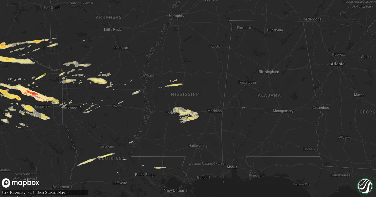
Hail Map in Mississippi on April 11, 2016
Get this storm
April 11 map
$229
one time, instant access
Download today. No call, no setup
Keep the $229
Bought the map and want the full workflow? Apply the entire $229 to a subscription within 7 days. None of it is wasted.
Every map, not just this one
This buys you this map. Subscription and you get every map we run, in the markets you choose from a few cities to whole states to nationwide. Plus real-time alerts the moment a storm fires.
Contact data
Name, contact info, occupancy, even credit band for addresses in the footprint. You go from where it hit to who to call.
Become the source they trust
Unlimited branding weather history reports on demand. You already have the documented answer ready for the property owner, and you are the one who showed up with it.
Property data and RoofTrace estimates
Pull up any address you have got, its value and the exact code rules for that jurisdiction, straight from One Click Code. Then RoofTrace estimates the squares, pitch, and roof value, priced the way you price.
Storm reports in Mississippi
Mississippi
| Date | Description |
|---|---|
| 04/11/20166:45 PM CDT | A local report indicates 65 MPH wind near N MERIDIAN STATION |
| 04/11/20166:45 PM CDT | A tree was blown down on highway 513. |
| 04/11/20166:43 PM CDT | Trees down on county road 16 east of louin as well as county road 31 area. |
| 04/11/20166:43 PM CDT | Trees were blown down along with power outages inside the city along highway 528. |
| 04/11/20166:30 PM CDT | Multiple trees down across multiple roads across the e half of lauderdale co. |
| 04/11/20166:30 PM CDT | Multiple trees down in the dalewood community near alice drive. |
| 04/11/20166:26 PM CDT | Trees down in meridian |
| 04/11/20166:25 PM CDT | Trees down along trickhambridge rd. Reported by emergency management. |
| 04/11/20166:22 PM CDT | Trees down in meridian |
| 04/11/20166:12 PM CDT | Public reported awning covering a picnic area relayed by media. |
| 04/11/20166:10 PM CDT | Several trees down along much of hwy 504 |
| 04/11/20166:05 PM CDT | Numerous trees down off hwy 35 and the n central part of the co. Power lines down as well. A lumber co had tin off a shed and a tin wall down. Possible tornado. |
| 04/11/20165:55 PM CDT | Showers of pea to dime sized hail with some quarter sized hail. Reported via social media. |
| 04/11/20165:50 PM CDT | Part of the roof was down at the lakeland clubhouse with a tree blown down. |
| 04/11/20165:50 PM CDT | At least 6 large trees down with a few snapped. Some fence damage as well. |
| 04/11/20165:50 PM CDT | Several trees down along hwy 13 and 538. |
| 04/11/20165:48 PM CDT | Trees down along mineral springs road. Reported by emergency management. |
| 04/11/20165:48 PM CDT | Trees down near tyler and shell oil road reported by emergency management |
| 04/11/20165:48 PM CDT | Trees down near highway 43 and interstate 20. Additional trees were down near mile marker 72 on interstate 20. |
| 04/11/20165:40 PM CDT | Several trees down in the sand hill community along lawrence...barker and sand hill roads. Reported by emergency management roughly between 1735 and 1750. |
| 04/11/20165:30 PM CDT | Public reported quarter sized hail around morton. |
| 04/11/20165:24 PM CDT | A tree was blown down at kay broadwater and boyd road. |
| 04/11/20165:20 PM CDT | Awning blown off a gas station near hugh ward and spillway road. Reported via social media. |
| 04/11/20165:20 PM CDT | Large tree fell through a house in the bay park subdivision. Reported by emergency manager. |
| 04/11/20165:15 PM CDT | Tree down on a home at n state and northside |
| 04/11/20165:12 PM CDT | Tree down in town |
| 04/11/20165:12 PM CDT | Public reported awning covering a picnic area relayed by media. |
| 04/11/20165:10 PM CDT | Tree down on hwy 16 w near madison co line. |
| 04/11/20165:09 PM CDT | A tree fell through a house |
| 04/11/20165:03 PM CDT | Trees down on joe coker road and joe coker circle reported by emergency management. |
| 04/11/20165:00 PM CDT | Tree down on pocohontas road reported by media. |
| 04/11/20164:47 PM CDT | A tree fell and damaged utility equipment off mcdaniel rd |
| 04/11/20164:40 PM CDT | Trees down on griffin spur rd |
| 04/11/20164:40 PM CDT | A utility pole was broken along us 51 |
| 04/11/20164:38 PM CDT | Windows were blown out of a mobile home and a shed was damaged |
| 04/11/20164:30 PM CDT | Trees down on mechanicsburg rd |
| 04/11/20164:30 PM CDT | A few trees down across hwy 433n and 432. |
| 04/11/20164:25 PM CDT | Multiple trees downed in vicksburg...including along briar ln... Lake hill dr... And bazinsky rd. |
| 04/11/20164:12 PM CDT | A utility pole was broken off us hwy 51 |
| 04/11/20163:53 PM CDT | Power poles down and roof damage to homes along hwy 7. |
| 04/11/20163:52 PM CDT | A barn was destroyed |
| 04/11/20163:50 PM CDT | A fire tower was blown over along us hwy 49 |
| 04/11/20163:43 PM CDT | Roof damage to a home on 16 section rd. |
| 04/11/20163:28 PM CDT | A local report indicates 1.00 inch wind near 1 N LEXINGTON |
Cities Impacted by Hail Map on April 11, 2016
- Waldo, AR
- Arcadia, LA
- Sulphur Springs, TX
- Milburn, OK
- Madill, OK
- Kenefic, OK
- Emerson, AR
- Magnolia, AR
- Mineola, TX
- Point, TX
- Emory, TX
- Edgewood, TX
- Alba, TX
- Karnack, TX
- Marshall, TX
- Plano, TX
- Richardson, TX
- Throckmorton, TX
- Kerens, TX
- Kingston, OK
- Lebanon, OK
- Lake Dallas, TX
- Denton, TX
- Allen, TX
- Wylie, TX
- Lavon, TX
- Princeton, TX
- Rockwall, TX
- Sachse, TX
- Temple, OK
- Athens, TX
- Bellevue, TX
- Henrietta, TX
- Trinidad, TX
- Malakoff, TX
- Ardmore, OK
- Tishomingo, OK
- Mill Creek, OK
- Mannsville, OK
- Quinlan, TX
- Wichita Falls, TX
- Windthorst, TX
- Scotland, TX
- Holliday, TX
- Raleigh, MS
- Morton, MS
- Overton, TX
- Marion, LA
- Farmersville, TX
- Caddo Mills, TX
- Knox City, TX
- Atoka, OK
- El Dorado, AR
- Canton, TX
- Eustace, TX
- Antlers, OK
- Caney, OK
- Lane, OK
- Caddo, OK
- Coleman, OK
- Lexington, MS
- Winnsboro, TX
- Leesburg, TX
- Pittsburg, TX
- Gilmer, TX
- Roanoke, TX
- Holden, LA
- Amite, LA
- Independence, LA
- Bluff City, AR
- Rosston, AR
- Prescott, AR
- Jacksboro, TX
- Sugartown, LA
- Merryville, LA
- Pitkin, LA
- Deridder, LA
- Texarkana, TX
- Texarkana, AR
- Nash, TX
- Tyler, TX
- Munday, TX
- Beckville, TX
- Carthage, TX
- Tatum, TX
- Henderson, TX
- Hamburg, AR
- Montrose, AR
- Ore City, TX
- Diana, TX
- Como, TX
- Pickton, TX
- Smithville, OK
- Bethel, OK
- Snow, OK
- Watson, OK
- Finley, OK
- Moyers, OK
- Rattan, OK
- Broken Bow, OK
- Brandon, MS
- Forest, MS
- Quitman, TX
- Mount Pleasant, TX
- Mount Holly, AR
- Smackover, AR
- Harleton, TX
- Graham, TX
- Weinert, TX
- Newcastle, TX
- Woodson, TX
- Haskell, TX
- Garland, TX
- Loveland, OK
- Walters, OK
- Chattanooga, OK
- Krum, TX
- Fouke, AR
- Alvord, TX
- Wickes, AR
- Grannis, AR
- Greenville, TX
- Winona, TX
- Van, TX
- Grand Saline, TX
- Soper, OK
- Boswell, OK
- Hugo, OK
- Bennington, OK
- Loranger, LA
- Chico, TX
- Bowie, TX
- Sunset, TX
- Forestburg, TX
- Talco, TX
- Emmet, AR
- Oak Grove, LA
- Fort Towson, OK
- Pelahatchie, MS
- Scroggins, TX
- Noble, OK
- Norman, OK
- Gibsland, LA
- Ponder, TX
- Royse City, TX
- Frisco, TX
- Argyle, TX
- Sanger, TX
- Mckinney, TX
- Fruitvale, TX
- Pilot Point, TX
- Decatur, TX
- Nevada, TX
- Aubrey, TX
- Prosper, TX
- The Colony, TX
- Lone Oak, TX
- Rowlett, TX
- Little Elm, TX
- Wills Point, TX
- Whitehouse, TX
- Lewisville, TX
- Carrollton, TX
- Lecompte, LA
- Jones, LA
- Muenster, TX
- Flowood, MS
- Yantis, TX
- Longview, TX
- Jefferson, TX
- Sawyer, OK
- Clarksville, TX
- Blossom, TX
- Calera, OK
- Bokchito, OK
- Durant, OK
- Bagwell, TX
- Grant, OK
- Telephone, TX
- Powderly, TX
- Detroit, TX
- Sumner, TX
- Arthur City, TX
- Paris, TX
- Mead, OK
- Cartwright, OK
- Colbert, OK
- Washington, AR
- Saratoga, AR
- Fulton, AR
- Jacksonville, TX
- Palestine, TX
- Monterey, LA
- Vidalia, LA
- Louise, MS
- Simmesport, LA
- Shreveport, LA
- Greenwood, LA
- Waskom, TX
- Dubach, LA
- Haslet, TX
- Justin, TX
- Cumby, TX
- Campbell, TX
- Collinston, LA
- Monroe, LA
- Oakdale, LA
- Cheneyville, LA
- Forest Hill, LA
- Glenmora, LA
- Lewisville, AR
- Garland City, AR
- Bridgeport, TX
- Doyline, LA
- Azle, TX
- Newark, TX
- Rhome, TX
- Saint Jo, TX
- Benton, LA
- Ringgold, TX
- Tchula, MS
- Durant, MS
- West, MS
- Belzoni, MS
- Lindale, TX
- Kilgore, TX
- Arp, TX
- Simsboro, LA
- Overbrook, OK
- Wilson, OK
- Hope, AR
- Pulaski, MS
- Jamestown, LA
- Lake, MS
- Pleasant Hill, LA
- Jackson, LA
- Slaughter, LA
- Opelousas, LA
- Hendrix, OK
- Ivanhoe, TX
- Troup, TX
- Mooringsport, LA
- Little Rock, AR
- Pine Grove, LA
- Marietta, OK
- Whitesboro, TX
- Healdton, OK
- Strong, AR
- Terrell, TX
- Commerce, TX
- Klondike, TX
- Bonnerdale, AR
- Pearcy, AR
- Frankston, TX
- Brashear, TX
- De Kalb, TX
- Bullard, TX
- Sibley, LA
- Ben Wheeler, TX
- Taylor, AR
- Ozan, AR
- Columbus, AR
- Cruger, MS
- Ringgold, LA
- Stamps, AR
- Doddridge, AR
- Walker, LA
- Dubberly, LA
- Bienville, LA
- Huttig, AR
- Ridgeland, MS
- Lawrence, MS
- Madison, MS
- Pearl, MS
- Jackson, MS
- Springer, OK
- Buckner, AR
- Chidester, AR
- Hatfield, AR
- Blue Ridge, TX
- Louin, MS
- Southlake, TX
- Flower Mound, TX
- Stephens, AR
- Avinger, TX
- Mendenhall, MS
- Magee, MS
- Mount Vernon, TX
- Dike, TX
- Minden, LA
- Ruston, LA
- Mabank, TX
- Wright City, OK
- Ringold, OK
- Valliant, OK
- Gladewater, TX
- Idabel, OK
- Braxton, MS
- Silver City, MS
- Fort Worth, TX
- Murchison, TX
- Queen City, TX
- Hampton, AR
- O'Brien, TX
- Seymour, TX
- Umpire, AR
- Tennessee Colony, TX
- Camden, AR
- Louann, AR
- Cove, AR
- Folsom, LA
- Bossier City, LA
- Chandler, TX
- Brownsboro, TX
- Sulphur Bluff, TX
- Ringling, OK
- Blanchard, OK
- Ashdown, AR
- San Augustine, TX
- Flint, TX
- Gallion, AL
- Dallas, TX
- Lone Grove, OK
- Washington, OK


