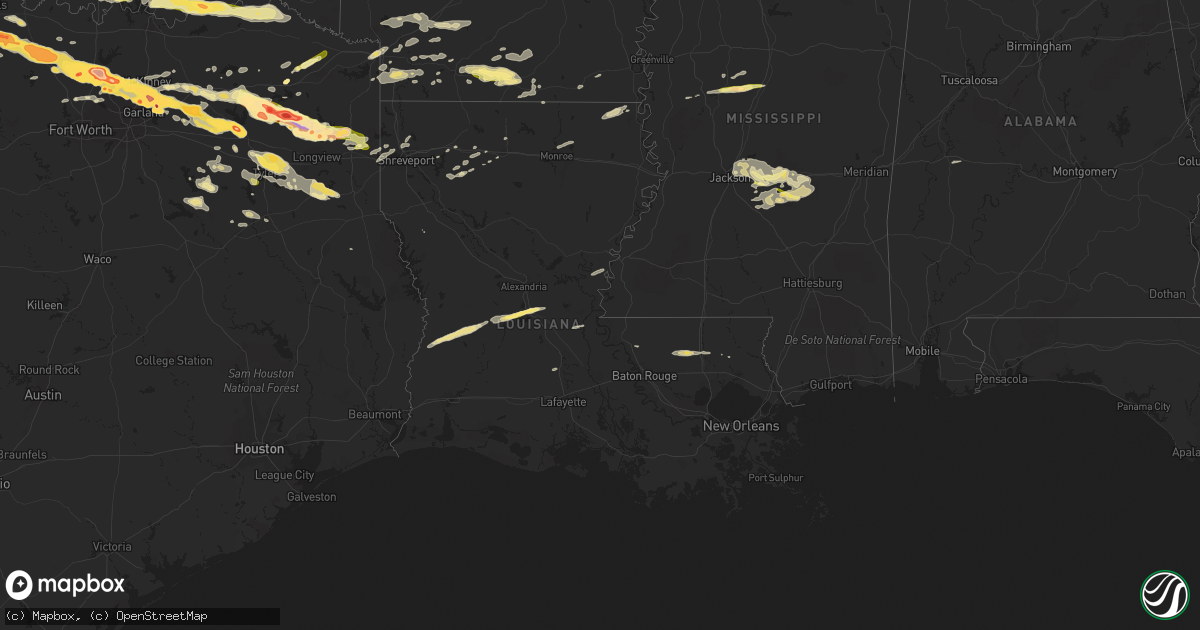
Hail Map in Louisiana on April 11, 2016
Get this storm
April 11 map
$229
one time, instant access
Download today. No call, no setup
Keep the $229
Bought the map and want the full workflow? Apply the entire $229 to a subscription within 7 days. None of it is wasted.
Every map, not just this one
This buys you this map. Subscription and you get every map we run, in the markets you choose from a few cities to whole states to nationwide. Plus real-time alerts the moment a storm fires.
Contact data
Name, contact info, occupancy, even credit band for addresses in the footprint. You go from where it hit to who to call.
Become the source they trust
Unlimited branding weather history reports on demand. You already have the documented answer ready for the property owner, and you are the one who showed up with it.
Property data and RoofTrace estimates
Pull up any address you have got, its value and the exact code rules for that jurisdiction, straight from One Click Code. Then RoofTrace estimates the squares, pitch, and roof value, priced the way you price.
Storm reports in Louisiana
Louisiana
| Date | Description |
|---|---|
| 04/11/20164:30 PM CDT | Trees snapped and uprooted |
| 04/11/20163:12 PM CDT | Several power poles blown down at the intersection of hwy 964 and hwy 955w. Time estimated by radar. |
Cities Impacted by Hail Map on April 11, 2016
- Waldo, AR
- Arcadia, LA
- Sulphur Springs, TX
- Milburn, OK
- Madill, OK
- Kenefic, OK
- Emerson, AR
- Magnolia, AR
- Mineola, TX
- Point, TX
- Emory, TX
- Edgewood, TX
- Alba, TX
- Karnack, TX
- Marshall, TX
- Plano, TX
- Richardson, TX
- Throckmorton, TX
- Kerens, TX
- Kingston, OK
- Lebanon, OK
- Lake Dallas, TX
- Denton, TX
- Allen, TX
- Wylie, TX
- Lavon, TX
- Princeton, TX
- Rockwall, TX
- Sachse, TX
- Temple, OK
- Athens, TX
- Bellevue, TX
- Henrietta, TX
- Trinidad, TX
- Malakoff, TX
- Ardmore, OK
- Tishomingo, OK
- Mill Creek, OK
- Mannsville, OK
- Quinlan, TX
- Wichita Falls, TX
- Windthorst, TX
- Scotland, TX
- Holliday, TX
- Raleigh, MS
- Morton, MS
- Overton, TX
- Marion, LA
- Farmersville, TX
- Caddo Mills, TX
- Knox City, TX
- Atoka, OK
- El Dorado, AR
- Canton, TX
- Eustace, TX
- Antlers, OK
- Caney, OK
- Lane, OK
- Caddo, OK
- Coleman, OK
- Lexington, MS
- Winnsboro, TX
- Leesburg, TX
- Pittsburg, TX
- Gilmer, TX
- Roanoke, TX
- Holden, LA
- Amite, LA
- Independence, LA
- Bluff City, AR
- Rosston, AR
- Prescott, AR
- Jacksboro, TX
- Sugartown, LA
- Merryville, LA
- Pitkin, LA
- Deridder, LA
- Texarkana, TX
- Texarkana, AR
- Nash, TX
- Tyler, TX
- Munday, TX
- Beckville, TX
- Carthage, TX
- Tatum, TX
- Henderson, TX
- Hamburg, AR
- Montrose, AR
- Ore City, TX
- Diana, TX
- Como, TX
- Pickton, TX
- Smithville, OK
- Bethel, OK
- Snow, OK
- Watson, OK
- Finley, OK
- Moyers, OK
- Rattan, OK
- Broken Bow, OK
- Brandon, MS
- Forest, MS
- Quitman, TX
- Mount Pleasant, TX
- Mount Holly, AR
- Smackover, AR
- Harleton, TX
- Graham, TX
- Weinert, TX
- Newcastle, TX
- Woodson, TX
- Haskell, TX
- Garland, TX
- Loveland, OK
- Walters, OK
- Chattanooga, OK
- Krum, TX
- Fouke, AR
- Alvord, TX
- Wickes, AR
- Grannis, AR
- Greenville, TX
- Winona, TX
- Van, TX
- Grand Saline, TX
- Soper, OK
- Boswell, OK
- Hugo, OK
- Bennington, OK
- Loranger, LA
- Chico, TX
- Bowie, TX
- Sunset, TX
- Forestburg, TX
- Talco, TX
- Emmet, AR
- Oak Grove, LA
- Fort Towson, OK
- Pelahatchie, MS
- Scroggins, TX
- Noble, OK
- Norman, OK
- Gibsland, LA
- Ponder, TX
- Royse City, TX
- Frisco, TX
- Argyle, TX
- Sanger, TX
- Mckinney, TX
- Fruitvale, TX
- Pilot Point, TX
- Decatur, TX
- Nevada, TX
- Aubrey, TX
- Prosper, TX
- The Colony, TX
- Lone Oak, TX
- Rowlett, TX
- Little Elm, TX
- Wills Point, TX
- Whitehouse, TX
- Lewisville, TX
- Carrollton, TX
- Lecompte, LA
- Jones, LA
- Muenster, TX
- Flowood, MS
- Yantis, TX
- Longview, TX
- Jefferson, TX
- Sawyer, OK
- Clarksville, TX
- Blossom, TX
- Calera, OK
- Bokchito, OK
- Durant, OK
- Bagwell, TX
- Grant, OK
- Telephone, TX
- Powderly, TX
- Detroit, TX
- Sumner, TX
- Arthur City, TX
- Paris, TX
- Mead, OK
- Cartwright, OK
- Colbert, OK
- Washington, AR
- Saratoga, AR
- Fulton, AR
- Jacksonville, TX
- Palestine, TX
- Monterey, LA
- Vidalia, LA
- Louise, MS
- Simmesport, LA
- Shreveport, LA
- Greenwood, LA
- Waskom, TX
- Dubach, LA
- Haslet, TX
- Justin, TX
- Cumby, TX
- Campbell, TX
- Collinston, LA
- Monroe, LA
- Oakdale, LA
- Cheneyville, LA
- Forest Hill, LA
- Glenmora, LA
- Lewisville, AR
- Garland City, AR
- Bridgeport, TX
- Doyline, LA
- Azle, TX
- Newark, TX
- Rhome, TX
- Saint Jo, TX
- Benton, LA
- Ringgold, TX
- Tchula, MS
- Durant, MS
- West, MS
- Belzoni, MS
- Lindale, TX
- Kilgore, TX
- Arp, TX
- Simsboro, LA
- Overbrook, OK
- Wilson, OK
- Hope, AR
- Pulaski, MS
- Jamestown, LA
- Lake, MS
- Pleasant Hill, LA
- Jackson, LA
- Slaughter, LA
- Opelousas, LA
- Hendrix, OK
- Ivanhoe, TX
- Troup, TX
- Mooringsport, LA
- Little Rock, AR
- Pine Grove, LA
- Marietta, OK
- Whitesboro, TX
- Healdton, OK
- Strong, AR
- Terrell, TX
- Commerce, TX
- Klondike, TX
- Bonnerdale, AR
- Pearcy, AR
- Frankston, TX
- Brashear, TX
- De Kalb, TX
- Bullard, TX
- Sibley, LA
- Ben Wheeler, TX
- Taylor, AR
- Ozan, AR
- Columbus, AR
- Cruger, MS
- Ringgold, LA
- Stamps, AR
- Doddridge, AR
- Walker, LA
- Dubberly, LA
- Bienville, LA
- Huttig, AR
- Ridgeland, MS
- Lawrence, MS
- Madison, MS
- Pearl, MS
- Jackson, MS
- Springer, OK
- Buckner, AR
- Chidester, AR
- Hatfield, AR
- Blue Ridge, TX
- Louin, MS
- Southlake, TX
- Flower Mound, TX
- Stephens, AR
- Avinger, TX
- Mendenhall, MS
- Magee, MS
- Mount Vernon, TX
- Dike, TX
- Minden, LA
- Ruston, LA
- Mabank, TX
- Wright City, OK
- Ringold, OK
- Valliant, OK
- Gladewater, TX
- Idabel, OK
- Braxton, MS
- Silver City, MS
- Fort Worth, TX
- Murchison, TX
- Queen City, TX
- Hampton, AR
- O'Brien, TX
- Seymour, TX
- Umpire, AR
- Tennessee Colony, TX
- Camden, AR
- Louann, AR
- Cove, AR
- Folsom, LA
- Bossier City, LA
- Chandler, TX
- Brownsboro, TX
- Sulphur Bluff, TX
- Ringling, OK
- Blanchard, OK
- Ashdown, AR
- San Augustine, TX
- Flint, TX
- Gallion, AL
- Dallas, TX
- Lone Grove, OK
- Washington, OK


