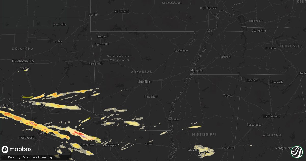
Hail Map in Arkansas on April 11, 2016
Get this storm
April 11 map
$229
one time, instant access
Download today. No call, no setup
Keep the $229
Bought the map and want the full workflow? Apply the entire $229 to a subscription within 7 days. None of it is wasted.
Every map, not just this one
This buys you this map. Subscription and you get every map we run, in the markets you choose from a few cities to whole states to nationwide. Plus real-time alerts the moment a storm fires.
Contact data
Name, contact info, occupancy, even credit band for addresses in the footprint. You go from where it hit to who to call.
Become the source they trust
Unlimited branding weather history reports on demand. You already have the documented answer ready for the property owner, and you are the one who showed up with it.
Property data and RoofTrace estimates
Pull up any address you have got, its value and the exact code rules for that jurisdiction, straight from One Click Code. Then RoofTrace estimates the squares, pitch, and roof value, priced the way you price.
Storm reports in Arkansas
Arkansas
| Date | Description |
|---|---|
| 04/11/20166:08 PM CDT | A local report indicates 1.00 inch wind near EMMET |
| 04/11/20166:05 PM CDT | Public post photo of one inch hail in hope on katv twitter page. |
| 04/11/20162:15 PM CDT | Trees and power lines down memorial park drive and highway 82 |
| 04/11/20161:58 PM CDT | El dorado coroner reports hail half dollar size in the city. |
| 04/11/20161:45 PM CDT | The city of texarkana has received lost of damage due to straight lines winds. Large tree limbs greater than 2 inches snapped off with nickel size hail some minor stree |
| 04/11/20161:15 PM CDT | Numerous trees and power lines down on the sau campus in magnolia. |
| 04/11/20161:10 PM CDT | Several trees and powerlines down across the easter part of the county. |
| 04/11/201612:58 PM CDT | Tree across highway 82 just inside the county line |
| 04/11/201612:45 PM CDT | Tree down on a house off of county road 18 south of lewisville. Trees and power lines were also downed across lafayette county. |
| 04/11/201612:45 PM CDT | The city of texarkana has received lots of damage due to straight lines winds. Large tree limbs greater than 2 inches snapped off with nickel size hail some minor stree |
| 04/11/201612:20 PM CDT | Trees and power lines down across county roads 216...217...and 43 just northwest of fouke. |
| 04/11/201612:15 PM CDT | Numerous trees and power lines down on old blackman ferry road near union road in southeast texarkana. A nws storm survey confirmed that this damage was consistent with |
| 04/11/201612:15 PM CDT | Several trees were downed on homes and vehicles at the shady acres mobile home park. |
| 04/11/201612:14 PM CDT | Large limb debris was reported on highway 270 west of white hall. |
| 04/11/201612:06 PM CDT | Reports of numerous limbs and trees down in redfield. There was also a report of a fence blown over on highway 365. |
| 04/11/201611:09 AM CDT | Large tree was reported down on highway 84. |
Cities Impacted by Hail Map on April 11, 2016
- Waldo, AR
- Arcadia, LA
- Sulphur Springs, TX
- Milburn, OK
- Madill, OK
- Kenefic, OK
- Emerson, AR
- Magnolia, AR
- Mineola, TX
- Point, TX
- Emory, TX
- Edgewood, TX
- Alba, TX
- Karnack, TX
- Marshall, TX
- Plano, TX
- Richardson, TX
- Throckmorton, TX
- Kerens, TX
- Kingston, OK
- Lebanon, OK
- Lake Dallas, TX
- Denton, TX
- Allen, TX
- Wylie, TX
- Lavon, TX
- Princeton, TX
- Rockwall, TX
- Sachse, TX
- Temple, OK
- Athens, TX
- Bellevue, TX
- Henrietta, TX
- Trinidad, TX
- Malakoff, TX
- Ardmore, OK
- Tishomingo, OK
- Mill Creek, OK
- Mannsville, OK
- Quinlan, TX
- Wichita Falls, TX
- Windthorst, TX
- Scotland, TX
- Holliday, TX
- Raleigh, MS
- Morton, MS
- Overton, TX
- Marion, LA
- Farmersville, TX
- Caddo Mills, TX
- Knox City, TX
- Atoka, OK
- El Dorado, AR
- Canton, TX
- Eustace, TX
- Antlers, OK
- Caney, OK
- Lane, OK
- Caddo, OK
- Coleman, OK
- Lexington, MS
- Winnsboro, TX
- Leesburg, TX
- Pittsburg, TX
- Gilmer, TX
- Roanoke, TX
- Holden, LA
- Amite, LA
- Independence, LA
- Bluff City, AR
- Rosston, AR
- Prescott, AR
- Jacksboro, TX
- Sugartown, LA
- Merryville, LA
- Pitkin, LA
- Deridder, LA
- Texarkana, TX
- Texarkana, AR
- Nash, TX
- Tyler, TX
- Munday, TX
- Beckville, TX
- Carthage, TX
- Tatum, TX
- Henderson, TX
- Hamburg, AR
- Montrose, AR
- Ore City, TX
- Diana, TX
- Como, TX
- Pickton, TX
- Smithville, OK
- Bethel, OK
- Snow, OK
- Watson, OK
- Finley, OK
- Moyers, OK
- Rattan, OK
- Broken Bow, OK
- Brandon, MS
- Forest, MS
- Quitman, TX
- Mount Pleasant, TX
- Mount Holly, AR
- Smackover, AR
- Harleton, TX
- Graham, TX
- Weinert, TX
- Newcastle, TX
- Woodson, TX
- Haskell, TX
- Garland, TX
- Loveland, OK
- Walters, OK
- Chattanooga, OK
- Krum, TX
- Fouke, AR
- Alvord, TX
- Wickes, AR
- Grannis, AR
- Greenville, TX
- Winona, TX
- Van, TX
- Grand Saline, TX
- Soper, OK
- Boswell, OK
- Hugo, OK
- Bennington, OK
- Loranger, LA
- Chico, TX
- Bowie, TX
- Sunset, TX
- Forestburg, TX
- Talco, TX
- Emmet, AR
- Oak Grove, LA
- Fort Towson, OK
- Pelahatchie, MS
- Scroggins, TX
- Noble, OK
- Norman, OK
- Gibsland, LA
- Ponder, TX
- Royse City, TX
- Frisco, TX
- Argyle, TX
- Sanger, TX
- Mckinney, TX
- Fruitvale, TX
- Pilot Point, TX
- Decatur, TX
- Nevada, TX
- Aubrey, TX
- Prosper, TX
- The Colony, TX
- Lone Oak, TX
- Rowlett, TX
- Little Elm, TX
- Wills Point, TX
- Whitehouse, TX
- Lewisville, TX
- Carrollton, TX
- Lecompte, LA
- Jones, LA
- Muenster, TX
- Flowood, MS
- Yantis, TX
- Longview, TX
- Jefferson, TX
- Sawyer, OK
- Clarksville, TX
- Blossom, TX
- Calera, OK
- Bokchito, OK
- Durant, OK
- Bagwell, TX
- Grant, OK
- Telephone, TX
- Powderly, TX
- Detroit, TX
- Sumner, TX
- Arthur City, TX
- Paris, TX
- Mead, OK
- Cartwright, OK
- Colbert, OK
- Washington, AR
- Saratoga, AR
- Fulton, AR
- Jacksonville, TX
- Palestine, TX
- Monterey, LA
- Vidalia, LA
- Louise, MS
- Simmesport, LA
- Shreveport, LA
- Greenwood, LA
- Waskom, TX
- Dubach, LA
- Haslet, TX
- Justin, TX
- Cumby, TX
- Campbell, TX
- Collinston, LA
- Monroe, LA
- Oakdale, LA
- Cheneyville, LA
- Forest Hill, LA
- Glenmora, LA
- Lewisville, AR
- Garland City, AR
- Bridgeport, TX
- Doyline, LA
- Azle, TX
- Newark, TX
- Rhome, TX
- Saint Jo, TX
- Benton, LA
- Ringgold, TX
- Tchula, MS
- Durant, MS
- West, MS
- Belzoni, MS
- Lindale, TX
- Kilgore, TX
- Arp, TX
- Simsboro, LA
- Overbrook, OK
- Wilson, OK
- Hope, AR
- Pulaski, MS
- Jamestown, LA
- Lake, MS
- Pleasant Hill, LA
- Jackson, LA
- Slaughter, LA
- Opelousas, LA
- Hendrix, OK
- Ivanhoe, TX
- Troup, TX
- Mooringsport, LA
- Little Rock, AR
- Pine Grove, LA
- Marietta, OK
- Whitesboro, TX
- Healdton, OK
- Strong, AR
- Terrell, TX
- Commerce, TX
- Klondike, TX
- Bonnerdale, AR
- Pearcy, AR
- Frankston, TX
- Brashear, TX
- De Kalb, TX
- Bullard, TX
- Sibley, LA
- Ben Wheeler, TX
- Taylor, AR
- Ozan, AR
- Columbus, AR
- Cruger, MS
- Ringgold, LA
- Stamps, AR
- Doddridge, AR
- Walker, LA
- Dubberly, LA
- Bienville, LA
- Huttig, AR
- Ridgeland, MS
- Lawrence, MS
- Madison, MS
- Pearl, MS
- Jackson, MS
- Springer, OK
- Buckner, AR
- Chidester, AR
- Hatfield, AR
- Blue Ridge, TX
- Louin, MS
- Southlake, TX
- Flower Mound, TX
- Stephens, AR
- Avinger, TX
- Mendenhall, MS
- Magee, MS
- Mount Vernon, TX
- Dike, TX
- Minden, LA
- Ruston, LA
- Mabank, TX
- Wright City, OK
- Ringold, OK
- Valliant, OK
- Gladewater, TX
- Idabel, OK
- Braxton, MS
- Silver City, MS
- Fort Worth, TX
- Murchison, TX
- Queen City, TX
- Hampton, AR
- O'Brien, TX
- Seymour, TX
- Umpire, AR
- Tennessee Colony, TX
- Camden, AR
- Louann, AR
- Cove, AR
- Folsom, LA
- Bossier City, LA
- Chandler, TX
- Brownsboro, TX
- Sulphur Bluff, TX
- Ringling, OK
- Blanchard, OK
- Ashdown, AR
- San Augustine, TX
- Flint, TX
- Gallion, AL
- Dallas, TX
- Lone Grove, OK
- Washington, OK


