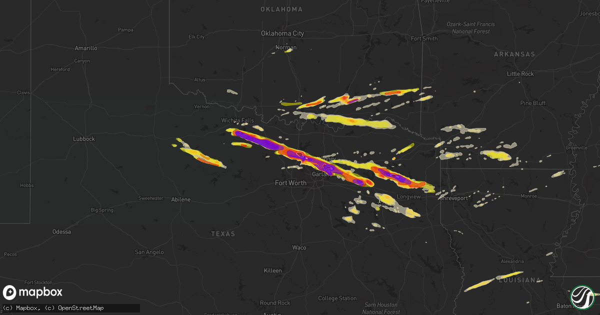
Hail Map on April 11, 2016
Get this storm
April 11 map
$229
one time, instant access
Download today. No call, no setup
Keep the $229
Bought the map and want the full workflow? Apply the entire $229 to a subscription within 7 days. None of it is wasted.
Every map, not just this one
This buys you this map. Subscription and you get every map we run, in the markets you choose from a few cities to whole states to nationwide. Plus real-time alerts the moment a storm fires.
Contact data
Name, contact info, occupancy, even credit band for addresses in the footprint. You go from where it hit to who to call.
Become the source they trust
Unlimited branding weather history reports on demand. You already have the documented answer ready for the property owner, and you are the one who showed up with it.
Property data and RoofTrace estimates
Pull up any address you have got, its value and the exact code rules for that jurisdiction, straight from One Click Code. Then RoofTrace estimates the squares, pitch, and roof value, priced the way you price.
Storm reports
Texas
| Date | Description |
|---|---|
| 04/11/20166:50 PM CDT | Public post photo of baseball size hail in east point community on kltv facebook. |
| 04/11/20166:49 PM CDT | Trees downalong fm2208 |
| 04/11/20166:48 PM CDT | Public post photo of ping pong size hail in scroggins community on kltv facebook page. |
| 04/11/20166:46 PM CDT | Quarter size hail in west tawakoni. |
| 04/11/20166:45 PM CDT | Baseball sized hail reported at union hill high school... |
| 04/11/20166:45 PM CDT | Quarter size hail in cash |
| 04/11/20166:44 PM CDT | Photo from kltv facebook page shows golfball size hail in diana community. |
| 04/11/20166:42 PM CDT | 60 mph wind gust 1 mile west of murray |
| 04/11/20166:42 PM CDT | Golfball size hail 1 mile west of murray |
| 04/11/20166:41 PM CDT | Golfball size hail near quinlan |
| 04/11/20166:40 PM CDT | Quarter size hail in quinlan. |
| 04/11/20166:40 PM CDT | Golfball size hail fell in the diana community. |
| 04/11/20166:36 PM CDT | 2 inch size hail in royce city |
| 04/11/20166:28 PM CDT | 1 inch hail covering the ground in throckmorton |
| 04/11/20166:25 PM CDT | 3 inch size hail in rockwall |
| 04/11/20166:24 PM CDT | A picture was posted to the kltv facebook page of large hail estimated to be the size of golfballs that fell in gilmer. |
| 04/11/20166:24 PM CDT | A large tree was blown down behind a home in gilmer. |
| 04/11/20166:19 PM CDT | Golfball sized hail near 205 and ralph hall parkway |
| 04/11/20166:17 PM CDT | Softball size hail reported in se wylie. |
| 04/11/20166:15 PM CDT | Delayed report...wind damage reported at tx-78 and w kirby st in wylie |
| 04/11/20166:15 PM CDT | Quarter size hail in rockwall |
| 04/11/20166:13 PM CDT | A picture was posted to the kltv facebook page of measured tennis ball size hail that fell near the bettie community in northern upshur county. |
| 04/11/20166:12 PM CDT | Baseball size hail in wylie reported by amateur radio |
| 04/11/20166:12 PM CDT | A local report indicates 1.00 inch wind near 2 NW THROCKMORTON |
| 04/11/20166:08 PM CDT | Delayed report...grapefruit size hail reported at eastshore rd in rockwall |
| 04/11/20166:07 PM CDT | Ping pong ball size hail in wylie. |
| 04/11/20166:05 PM CDT | A local report indicates 1.75 inch wind near MOUNT PLEASANT |
| 04/11/20166:03 PM CDT | A picture was posted to the kltv facebook page of large hail that was measured to be three and a half inches in diameter that fell in the simpsonville community in nort |
| 04/11/20166:03 PM CDT | Trained spotter reports half dollar sized hail... |
| 04/11/20166:03 PM CDT | On murphy road in parker texas |
| 04/11/20166:03 PM CDT | 2 inch hail in allan at the allan event center |
| 04/11/20166:03 PM CDT | Public post picture of golfball size hail in the grice community on kltv facebook page. |
| 04/11/20166:03 PM CDT | A local report indicates 1.75 inch wind near LUCAS |
| 04/11/20165:57 PM CDT | 2 inch size hail in plano |
| 04/11/20165:56 PM CDT | Hail size from ping pong to hen egg size fell for 8 mins. Occurred at intersection of malone and main in allen... Tx. |
| 04/11/20165:55 PM CDT | Half dollar size hail in south mckinney |
| 04/11/20165:54 PM CDT | Ping pong ball size hail in allen |
| 04/11/20165:53 PM CDT | In newsome golf ball size hail |
| 04/11/20165:53 PM CDT | Between two and three inch diameter size hail fell in the pineview community near the wood...camp...and upshur county line. |
| 04/11/20165:50 PM CDT | Public post photo of baseball size hail in east point community on kltv facebook. |
| 04/11/20165:50 PM CDT | Hail up to egg size near custer and hwy 121 in north plano |
| 04/11/20165:50 PM CDT | Public post photo of 2 inch hail in the stout community on kltv facebook. |
| 04/11/20165:48 PM CDT | Public post photo of ping pong size hail in scroggins community on kltv facebook page. |
| 04/11/20165:48 PM CDT | 2 inch hail reported in ne frisco |
| 04/11/20165:45 PM CDT | 70 mph wind gust 1 mile west of frisco. Tree branches down |
| 04/11/20165:45 PM CDT | Golball size hail in plano nw of independence and mcdermott |
| 04/11/20165:42 PM CDT | Quarter size hail in frisco |
| 04/11/20165:41 PM CDT | A picture was posted to the kltv facebook page of large hail estimated to be between 2 and 2 1/2 inches in diameter that fell in winnsboro. |
| 04/11/20165:40 PM CDT | Public post photo of golfball size hail near lake winnsboro on kltv facebook page. |
| 04/11/20165:37 PM CDT | Baseball size hail in little elm |
| 04/11/20165:36 PM CDT | Spotters report golball size hail in little elm. |
| 04/11/20165:35 PM CDT | Hail ranged from the size of peas to ping pong balls. |
| 04/11/20165:33 PM CDT | Asos at denton reports 66 mph wind gust |
| 04/11/20165:31 PM CDT | Quarter size hail reported in como |
| 04/11/20165:30 PM CDT | Ping pong ball size hail in frisco |
| 04/11/20165:30 PM CDT | Delayed report...baseball size hail reported 1 mile n of corinth |
| 04/11/20165:26 PM CDT | Quarter size hail reported 5 e of denton |
| 04/11/20165:25 PM CDT | Tennis ball size hail reported in denton. |
| 04/11/20165:23 PM CDT | Quarter size hail in corinth |
| 04/11/20165:22 PM CDT | Reports of quarter size hail 4 miles s of sulphur springs. |
| 04/11/20165:20 PM CDT | Delayed report...grapefruit size hail at audra lane and east mckinney st |
| 04/11/20165:20 PM CDT | Golfball size hail at the corner of parvin st and mccormick st |
| 04/11/20165:15 PM CDT | Quarter sized hail reported near highway 19 north and cr 3417 |
| 04/11/20165:15 PM CDT | Golfball size hail reported at locust dr and university st in denton |
| 04/11/20165:14 PM CDT | Golfball size hail in northeast denton |
| 04/11/20165:12 PM CDT | Tennis ball size hail 4 north of ponder |
| 04/11/20165:10 PM CDT | Golfball size hail in krum |
| 04/11/20165:07 PM CDT | Ping pong ball size hail 1 mile nne of plano |
| 04/11/20164:56 PM CDT | Report of quarter size hail 4 miles s of slidell |
| 04/11/20164:56 PM CDT | Measured 62 mph wind gust 4 miles s of slidell |
| 04/11/20164:53 PM CDT | Golfball size hail reported 3 miles west of slidell |
| 04/11/20164:36 PM CDT | Nearly covering the ground |
| 04/11/20164:33 PM CDT | Report of 1 mile north of alvord |
| 04/11/20164:30 PM CDT | Located along 287 between alvord and sunset near the county line |
| 04/11/20164:28 PM CDT | Tennis ball size hail reported in sunset |
| 04/11/20164:13 PM CDT | Em reports golfball size hail between bowie and sunset |
| 04/11/20164:11 PM CDT | Reports of one inch hail 2 north of sunset |
| 04/11/20164:09 PM CDT | Media reports 3 inch hail in bowie at 287 exit. |
| 04/11/20164:00 PM CDT | Quarter size hail in novice... Lamar county. |
| 04/11/20163:53 PM CDT | Quarter size hail 8-10 miles n of paris |
| 04/11/20163:50 PM CDT | A local report indicates 2.00 inch wind near BUFFALO SPRINGS |
| 04/11/20163:45 PM CDT | Relayed by kauz-tv. |
| 04/11/20163:45 PM CDT | A local report indicates 1.75 inch wind near VASHTI |
| 04/11/20163:37 PM CDT | A local report indicates 2.50 inch wind near JOY |
| 04/11/20163:30 PM CDT | A local report indicates 1.75 inch wind near 3 SSW BLUEGROVE |
| 04/11/20163:10 PM CDT | A local report indicates 1.50 inch wind near SCOTLAND |
| 04/11/20163:05 PM CDT | Relayed through texomas twitter account. |
| 04/11/201612:10 PM CDT | Numerous trees and power lines down in liberty-eylau. |
| 04/11/20167:05 AM CDT | Very large hail to hen egg size and very strong winds several miles ssw of the city of emory. |
| 04/10/20169:15 PM CDT | Tree down on fm 1798 in the pine hill community near the rusk/panola county line. |
| 04/10/20169:05 PM CDT | Tree down across the 10000 block of fm 2011 in northern rusk county. |
| 04/10/20168:15 PM CDT | A picture was posted to the kltv facebook page of quarter size hail that fell in noonday. |
| 04/10/20168:11 PM CDT | Public post photo of quarter size hail in flint/gresham area on kltv facebook page. |
| 04/10/20168:10 PM CDT | Public post photo on kltv facebook page of ping pong size hail in winona. |
| 04/10/20167:30 PM CDT | Golfball to baseball sized hail reported near fm 779 near the county line |
| 04/10/20167:30 PM CDT | A local report indicates 1.00 inch wind near 5 NE MARSHALL |
| 04/10/20167:26 PM CDT | Public post picture of quarter size hail near lake holbrook on kltv facebook page. |
| 04/10/20167:25 PM CDT | A picture was posted to kltv facebook page of half dollar size hail in the golden community. |
| 04/10/20167:20 PM CDT | A picture was posted to kltv facebook page of golfball size hail in alba. |
| 04/10/20167:10 PM CDT | Dime to quarter sized hail in emory |
| 04/10/20167:05 PM CDT | Hail to the size of hen eggs fell several miles ssw of the city of emory. |
| 04/10/20167:00 PM CDT | A local report indicates 1.00 inch wind near POINT |
| 04/10/20167:00 PM CDT | Reported near the lake tawakoni dam near the county line |
Alabama
| Date | Description |
|---|---|
| 04/11/20166:55 PM CDT | Two trees down across cr 13...2 miles north of hwy 80. Winds estimated around 40 mph based on radar. Time estimated from radar. |
| 04/11/20166:40 PM CDT | Tree down across cr 76 near the state line. Winds estimated at 40 mph based on radar. Time estimated from radar. |
| 04/10/201610:54 PM CDT | Tree down scross county road 65. Winds est at 40mph. |
Mississippi
| Date | Description |
|---|---|
| 04/11/20166:45 PM CDT | A local report indicates 65 MPH wind near N MERIDIAN STATION |
| 04/11/20166:45 PM CDT | A tree was blown down on highway 513. |
| 04/11/20166:43 PM CDT | Trees were blown down along with power outages inside the city along highway 528. |
| 04/11/20166:43 PM CDT | Trees down on county road 16 east of louin as well as county road 31 area. |
| 04/11/20166:30 PM CDT | Multiple trees down across multiple roads across the e half of lauderdale co. |
| 04/11/20166:30 PM CDT | Multiple trees down in the dalewood community near alice drive. |
| 04/11/20166:26 PM CDT | Trees down in meridian |
| 04/11/20166:25 PM CDT | Trees down along trickhambridge rd. Reported by emergency management. |
| 04/11/20166:22 PM CDT | Trees down in meridian |
| 04/11/20166:12 PM CDT | Public reported awning covering a picnic area relayed by media. |
| 04/11/20166:10 PM CDT | Several trees down along much of hwy 504 |
| 04/11/20166:05 PM CDT | Numerous trees down off hwy 35 and the n central part of the co. Power lines down as well. A lumber co had tin off a shed and a tin wall down. Possible tornado. |
| 04/11/20165:55 PM CDT | Showers of pea to dime sized hail with some quarter sized hail. Reported via social media. |
| 04/11/20165:50 PM CDT | Several trees down along hwy 13 and 538. |
| 04/11/20165:50 PM CDT | At least 6 large trees down with a few snapped. Some fence damage as well. |
| 04/11/20165:50 PM CDT | Part of the roof was down at the lakeland clubhouse with a tree blown down. |
| 04/11/20165:48 PM CDT | Trees down near tyler and shell oil road reported by emergency management |
| 04/11/20165:48 PM CDT | Trees down along mineral springs road. Reported by emergency management. |
| 04/11/20165:48 PM CDT | Trees down near highway 43 and interstate 20. Additional trees were down near mile marker 72 on interstate 20. |
| 04/11/20165:40 PM CDT | Several trees down in the sand hill community along lawrence...barker and sand hill roads. Reported by emergency management roughly between 1735 and 1750. |
| 04/11/20165:30 PM CDT | Public reported quarter sized hail around morton. |
| 04/11/20165:24 PM CDT | A tree was blown down at kay broadwater and boyd road. |
| 04/11/20165:20 PM CDT | Awning blown off a gas station near hugh ward and spillway road. Reported via social media. |
| 04/11/20165:20 PM CDT | Large tree fell through a house in the bay park subdivision. Reported by emergency manager. |
| 04/11/20165:15 PM CDT | Tree down on a home at n state and northside |
| 04/11/20165:12 PM CDT | Public reported awning covering a picnic area relayed by media. |
| 04/11/20165:12 PM CDT | Tree down in town |
| 04/11/20165:10 PM CDT | Tree down on hwy 16 w near madison co line. |
| 04/11/20165:09 PM CDT | A tree fell through a house |
| 04/11/20165:03 PM CDT | Trees down on joe coker road and joe coker circle reported by emergency management. |
| 04/11/20165:00 PM CDT | Tree down on pocohontas road reported by media. |
| 04/11/20164:47 PM CDT | A tree fell and damaged utility equipment off mcdaniel rd |
| 04/11/20164:40 PM CDT | Trees down on griffin spur rd |
| 04/11/20164:40 PM CDT | A utility pole was broken along us 51 |
| 04/11/20164:38 PM CDT | Windows were blown out of a mobile home and a shed was damaged |
| 04/11/20164:30 PM CDT | A few trees down across hwy 433n and 432. |
| 04/11/20164:30 PM CDT | Trees down on mechanicsburg rd |
| 04/11/20164:25 PM CDT | Multiple trees downed in vicksburg...including along briar ln... Lake hill dr... And bazinsky rd. |
| 04/11/20164:12 PM CDT | A utility pole was broken off us hwy 51 |
| 04/11/20163:53 PM CDT | Power poles down and roof damage to homes along hwy 7. |
| 04/11/20163:52 PM CDT | A barn was destroyed |
| 04/11/20163:50 PM CDT | A fire tower was blown over along us hwy 49 |
| 04/11/20163:43 PM CDT | Roof damage to a home on 16 section rd. |
| 04/11/20163:28 PM CDT | A local report indicates 1.00 inch wind near 1 N LEXINGTON |
Arkansas
| Date | Description |
|---|---|
| 04/11/20166:08 PM CDT | A local report indicates 1.00 inch wind near EMMET |
| 04/11/20166:05 PM CDT | Public post photo of one inch hail in hope on katv twitter page. |
| 04/11/20162:15 PM CDT | Trees and power lines down memorial park drive and highway 82 |
| 04/11/20161:58 PM CDT | El dorado coroner reports hail half dollar size in the city. |
| 04/11/20161:45 PM CDT | The city of texarkana has received lost of damage due to straight lines winds. Large tree limbs greater than 2 inches snapped off with nickel size hail some minor stree |
| 04/11/20161:15 PM CDT | Numerous trees and power lines down on the sau campus in magnolia. |
| 04/11/20161:10 PM CDT | Several trees and powerlines down across the easter part of the county. |
| 04/11/201612:58 PM CDT | Tree across highway 82 just inside the county line |
| 04/11/201612:45 PM CDT | Tree down on a house off of county road 18 south of lewisville. Trees and power lines were also downed across lafayette county. |
| 04/11/201612:45 PM CDT | The city of texarkana has received lots of damage due to straight lines winds. Large tree limbs greater than 2 inches snapped off with nickel size hail some minor stree |
| 04/11/201612:20 PM CDT | Trees and power lines down across county roads 216...217...and 43 just northwest of fouke. |
| 04/11/201612:15 PM CDT | Several trees were downed on homes and vehicles at the shady acres mobile home park. |
| 04/11/201612:15 PM CDT | Numerous trees and power lines down on old blackman ferry road near union road in southeast texarkana. A nws storm survey confirmed that this damage was consistent with |
| 04/11/201612:14 PM CDT | Large limb debris was reported on highway 270 west of white hall. |
| 04/11/201612:06 PM CDT | Reports of numerous limbs and trees down in redfield. There was also a report of a fence blown over on highway 365. |
| 04/11/201611:09 AM CDT | Large tree was reported down on highway 84. |
Oklahoma
| Date | Description |
|---|---|
| 04/11/20165:19 PM CDT | A local report indicates 1.00 inch wind near 1 N NOBLE |
| 04/11/20165:17 PM CDT | A local report indicates 1.00 inch wind near NOBLE |
| 04/11/20165:13 PM CDT | A local report indicates 1.00 inch wind near NOBLE |
| 04/11/20163:25 PM CDT | A local report indicates 1.75 inch wind near BATTIEST |
| 04/11/20163:24 PM CDT | A local report indicates 1.00 inch wind near 10 SSE BOSWELL |
| 04/11/20163:18 PM CDT | A local report indicates 1.00 inch wind near 10 SE NASHOBA |
| 04/11/20163:15 PM CDT | Golfball size hail occurred several miles north of telephone. |
| 04/11/20162:38 PM CDT | A local report indicates 1.00 inch wind near MOYERS |
| 04/11/20162:11 PM CDT | A local report indicates 1.00 inch wind near 5 N WILLIS |
| 04/11/20162:05 PM CDT | Relayed by atoka county sheriff department. |
| 04/11/20161:29 PM CDT | A local report indicates 1.75 inch wind near TISHOMINGO |
| 04/11/20161:15 PM CDT | Covering the ground |
| 04/11/20161:15 PM CDT | A local report indicates 1.75 inch wind near MANNSVILLE |
Louisiana
| Date | Description |
|---|---|
| 04/11/20164:30 PM CDT | Trees snapped and uprooted |
| 04/11/20163:12 PM CDT | Several power poles blown down at the intersection of hwy 964 and hwy 955w. Time estimated by radar. |
Cities Impacted by Hail Map on April 11, 2016
- Waldo, AR
- Arcadia, LA
- Sulphur Springs, TX
- Milburn, OK
- Madill, OK
- Kenefic, OK
- Emerson, AR
- Magnolia, AR
- Mineola, TX
- Point, TX
- Emory, TX
- Edgewood, TX
- Alba, TX
- Karnack, TX
- Marshall, TX
- Plano, TX
- Richardson, TX
- Throckmorton, TX
- Kerens, TX
- Kingston, OK
- Lebanon, OK
- Lake Dallas, TX
- Denton, TX
- Allen, TX
- Wylie, TX
- Lavon, TX
- Princeton, TX
- Rockwall, TX
- Sachse, TX
- Temple, OK
- Athens, TX
- Bellevue, TX
- Henrietta, TX
- Trinidad, TX
- Malakoff, TX
- Ardmore, OK
- Tishomingo, OK
- Mill Creek, OK
- Mannsville, OK
- Quinlan, TX
- Wichita Falls, TX
- Windthorst, TX
- Scotland, TX
- Holliday, TX
- Raleigh, MS
- Morton, MS
- Overton, TX
- Marion, LA
- Farmersville, TX
- Caddo Mills, TX
- Knox City, TX
- Atoka, OK
- El Dorado, AR
- Canton, TX
- Eustace, TX
- Antlers, OK
- Caney, OK
- Lane, OK
- Caddo, OK
- Coleman, OK
- Lexington, MS
- Winnsboro, TX
- Leesburg, TX
- Pittsburg, TX
- Gilmer, TX
- Roanoke, TX
- Holden, LA
- Amite, LA
- Independence, LA
- Bluff City, AR
- Rosston, AR
- Prescott, AR
- Jacksboro, TX
- Sugartown, LA
- Merryville, LA
- Pitkin, LA
- Deridder, LA
- Texarkana, TX
- Texarkana, AR
- Nash, TX
- Tyler, TX
- Munday, TX
- Beckville, TX
- Carthage, TX
- Tatum, TX
- Henderson, TX
- Hamburg, AR
- Montrose, AR
- Ore City, TX
- Diana, TX
- Como, TX
- Pickton, TX
- Smithville, OK
- Bethel, OK
- Snow, OK
- Watson, OK
- Finley, OK
- Moyers, OK
- Rattan, OK
- Broken Bow, OK
- Brandon, MS
- Forest, MS
- Quitman, TX
- Mount Pleasant, TX
- Mount Holly, AR
- Smackover, AR
- Harleton, TX
- Graham, TX
- Weinert, TX
- Newcastle, TX
- Woodson, TX
- Haskell, TX
- Garland, TX
- Loveland, OK
- Walters, OK
- Chattanooga, OK
- Krum, TX
- Fouke, AR
- Alvord, TX
- Wickes, AR
- Grannis, AR
- Greenville, TX
- Winona, TX
- Van, TX
- Grand Saline, TX
- Soper, OK
- Boswell, OK
- Hugo, OK
- Bennington, OK
- Loranger, LA
- Chico, TX
- Bowie, TX
- Sunset, TX
- Forestburg, TX
- Talco, TX
- Emmet, AR
- Oak Grove, LA
- Fort Towson, OK
- Pelahatchie, MS
- Scroggins, TX
- Noble, OK
- Norman, OK
- Gibsland, LA
- Ponder, TX
- Royse City, TX
- Frisco, TX
- Argyle, TX
- Sanger, TX
- Mckinney, TX
- Fruitvale, TX
- Pilot Point, TX
- Decatur, TX
- Nevada, TX
- Aubrey, TX
- Prosper, TX
- The Colony, TX
- Lone Oak, TX
- Rowlett, TX
- Little Elm, TX
- Wills Point, TX
- Whitehouse, TX
- Lewisville, TX
- Carrollton, TX
- Lecompte, LA
- Jones, LA
- Muenster, TX
- Flowood, MS
- Yantis, TX
- Longview, TX
- Jefferson, TX
- Sawyer, OK
- Clarksville, TX
- Blossom, TX
- Calera, OK
- Bokchito, OK
- Durant, OK
- Bagwell, TX
- Grant, OK
- Telephone, TX
- Powderly, TX
- Detroit, TX
- Sumner, TX
- Arthur City, TX
- Paris, TX
- Mead, OK
- Cartwright, OK
- Colbert, OK
- Washington, AR
- Saratoga, AR
- Fulton, AR
- Jacksonville, TX
- Palestine, TX
- Monterey, LA
- Vidalia, LA
- Louise, MS
- Simmesport, LA
- Shreveport, LA
- Greenwood, LA
- Waskom, TX
- Dubach, LA
- Haslet, TX
- Justin, TX
- Cumby, TX
- Campbell, TX
- Collinston, LA
- Monroe, LA
- Oakdale, LA
- Cheneyville, LA
- Forest Hill, LA
- Glenmora, LA
- Lewisville, AR
- Garland City, AR
- Bridgeport, TX
- Doyline, LA
- Azle, TX
- Newark, TX
- Rhome, TX
- Saint Jo, TX
- Benton, LA
- Ringgold, TX
- Tchula, MS
- Durant, MS
- West, MS
- Belzoni, MS
- Lindale, TX
- Kilgore, TX
- Arp, TX
- Simsboro, LA
- Overbrook, OK
- Wilson, OK
- Hope, AR
- Pulaski, MS
- Jamestown, LA
- Lake, MS
- Pleasant Hill, LA
- Jackson, LA
- Slaughter, LA
- Opelousas, LA
- Hendrix, OK
- Ivanhoe, TX
- Troup, TX
- Mooringsport, LA
- Little Rock, AR
- Pine Grove, LA
- Marietta, OK
- Whitesboro, TX
- Healdton, OK
- Strong, AR
- Terrell, TX
- Commerce, TX
- Klondike, TX
- Bonnerdale, AR
- Pearcy, AR
- Frankston, TX
- Brashear, TX
- De Kalb, TX
- Bullard, TX
- Sibley, LA
- Ben Wheeler, TX
- Taylor, AR
- Ozan, AR
- Columbus, AR
- Cruger, MS
- Ringgold, LA
- Stamps, AR
- Doddridge, AR
- Walker, LA
- Dubberly, LA
- Bienville, LA
- Huttig, AR
- Ridgeland, MS
- Lawrence, MS
- Madison, MS
- Pearl, MS
- Jackson, MS
- Springer, OK
- Buckner, AR
- Chidester, AR
- Hatfield, AR
- Blue Ridge, TX
- Louin, MS
- Southlake, TX
- Flower Mound, TX
- Stephens, AR
- Avinger, TX
- Mendenhall, MS
- Magee, MS
- Mount Vernon, TX
- Dike, TX
- Minden, LA
- Ruston, LA
- Mabank, TX
- Wright City, OK
- Ringold, OK
- Valliant, OK
- Gladewater, TX
- Idabel, OK
- Braxton, MS
- Silver City, MS
- Fort Worth, TX
- Murchison, TX
- Queen City, TX
- Hampton, AR
- O'Brien, TX
- Seymour, TX
- Umpire, AR
- Tennessee Colony, TX
- Camden, AR
- Louann, AR
- Cove, AR
- Folsom, LA
- Bossier City, LA
- Chandler, TX
- Brownsboro, TX
- Sulphur Bluff, TX
- Ringling, OK
- Blanchard, OK
- Ashdown, AR
- San Augustine, TX
- Flint, TX
- Gallion, AL
- Dallas, TX
- Lone Grove, OK
- Washington, OK