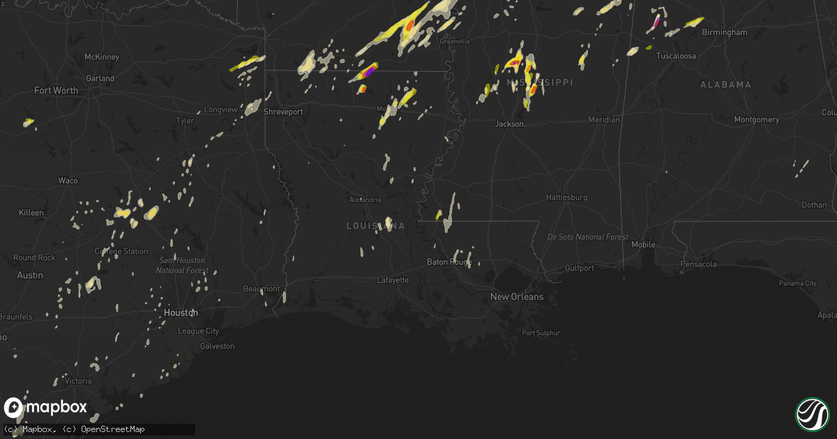
Hail Map in Louisiana on April 7, 2019
Get this storm
April 7 map
$229
one time, instant access
Download today. No call, no setup
Keep the $229
Bought the map and want the full workflow? Apply the entire $229 to a subscription within 7 days. None of it is wasted.
Every map, not just this one
This buys you this map. Subscription and you get every map we run, in the markets you choose from a few cities to whole states to nationwide. Plus real-time alerts the moment a storm fires.
Contact data
Name, contact info, occupancy, even credit band for addresses in the footprint. You go from where it hit to who to call.
Become the source they trust
Unlimited branding weather history reports on demand. You already have the documented answer ready for the property owner, and you are the one who showed up with it.
Property data and RoofTrace estimates
Pull up any address you have got, its value and the exact code rules for that jurisdiction, straight from One Click Code. Then RoofTrace estimates the squares, pitch, and roof value, priced the way you price.
Storm reports in Louisiana
Louisiana
| Date | Description |
|---|---|
| 04/07/20196:35 PM CDT | A small tree was blown down in mangham and partially blocked a road. |
| 04/07/20196:25 PM CDT | Some trees were blown down. |
| 04/07/20196:20 PM CDT | A tree was blown down on highway 909. Wind gust was likely subsevere at this time. |
| 04/07/20195:25 PM CDT | Multiple reports of damage in the southlake plantation community of youngsville. Tree down across fence as well as other fence damage and some minor roof and shingle da |
| 04/07/20195:18 PM CDT | Highway 71... North of hwy 158 trees down blocking roadway. |
| 04/07/20195:15 PM CDT | Multiple trees reported down across west part of the parish. |
| 04/07/20195:00 PM CDT | Home anemometer recorded 60mph wind gust. Relayed by broadcast media. Time estimated from radar. |
| 04/07/20194:50 PM CDT | Numerous trees down. |
| 04/07/20194:45 PM CDT | Several trees down. |
| 04/07/20194:30 PM CDT | Public reports and broadcast media video showing trees down in marksville. Power lines also reported down with some scattered reports of minor property damage. |
| 04/07/20194:15 PM CDT | Public post to social media of a tree blocking hwy 106 near bayou chicot. Time estimated from radar. |
| 04/07/20193:45 PM CDT | Public report hail via social media. |
| 04/07/20193:30 PM CDT | Several trees down in and around the community of oakland reported by the parish emergency manager. |
| 04/07/20193:15 PM CDT | Wind gust of 53kts reported at southland field airport asos - kuxl. |
| 04/07/20192:55 PM CDT | Multiple trees down around carlyss with several along dave dugas rd. |
| 04/07/20192:54 PM CDT | Powerlines and poles reported down on johnny benoit road in hackberry. |
| 04/07/20192:35 PM CDT | Corrects previous hail report from 11 ssw brownsville-bawcom. Public send video of hail in the luna community via ktve-tv facebook page. |
| 04/07/20192:31 PM CDT | Nws employee report of large tree down just north of train tracks along hwy 27 leading into dequincy. Time estimated by radar. |
| 04/07/20192:10 PM CDT | Corrects previous hail report from 11 ssw strong. Corrects previous hail report from 11 ssw strong. Public posts photo of hail covering the ground in the truxno communi |
| 04/07/20192:01 PM CDT | A local report indicates 1.00 inch wind near 5 SE MER ROUGE |
| 04/07/20191:50 PM CDT | Nickel to quarter size hail just north of oak ridge. |
| 04/07/20198:14 AM CDT | Eoc reported power poles leaning near river road in norco in st. Charles parish... La. |
| 04/07/20198:14 AM CDT | Eoc reported trees down in the montz area of st. Charles parish... La. |
| 04/07/20193:05 AM CDT | At 805 PM CDT, severe thunderstorms were located along a line extending from near Afton to 6 miles southwest of Yokena, moving northeast at 45 mph. HAZARD...60 mph wind gusts. SOURCE...Radar indicated. IMPACT...Expect damage to roofs, siding, and trees. Severe thunderstorms will be near... Tallulah and Yokena around 815 PM CDT. Vicksburg and Le Tourneau around 820 PM CDT. Mansford around 825 PM CDT. Omega around 830 PM CDT. Eagle Bend and Bovina around 835 PM CDT. Redwood and Flowers around 845 PM CDT. Valley Park and Oak Ridge around 850 PM CDT.Other locations impacted by these severe thunderstorms include Mound,Delta and Richmond. |
| 04/07/20192:49 AM CDT | At 749 PM CDT, severe thunderstorms were located along a line extending from near Darlington to near Montpelier to near French Settlement, moving northeast at 25 mph. HAZARD...70 mph wind gusts. SOURCE...Radar indicated. IMPACT...Expect considerable tree damage. Damage is likely to mobile homes, roofs, and outbuildings. Locations impacted include... Hammond, Liberty, Greensburg, Amite, Ponchatoula, Walker, Amite City, Magnolia, Kentwood, Livingston, Independence, Roseland, French Settlement, Albany, Port Vincent, Springfield, Osyka, Montpelier, Smithdale and Darlington. |
| 04/07/20192:42 AM CDT | At 741 PM CDT, severe thunderstorms were located along a line extending from near Convent to 8 miles west of Leeville, moving east at 40 mph. HAZARD...60 mph wind gusts. SOURCE...Radar indicated. IMPACT...Expect damage to roofs, siding, and trees. Locations impacted include... Reserve, Cut Off, Galliano, Avondale, Larose, Hahnville, Laplace, Metairie, Harahan, Gramercy, Lutcher, Lockport, Golden Meadow, Jean Lafitte, Sorrento, Springfield, Mathews, Montz, Luling and Garyville. |
| 04/07/20192:26 AM CDT | At 726 PM CDT, severe thunderstorms were located along a line extending from near Zachary to Watson to near Denham Springs, moving northeast at 30 mph. HAZARD...70 mph wind gusts. SOURCE...Radar indicated. IMPACT...Expect considerable tree damage. Damage is likely to mobile homes, roofs, and outbuildings. Locations impacted include... Zachary, Baker, Denham Springs, Clinton, Walker, Slaughter, Wilson, Norwood, Pride, Watson, Darlington and Greenwell Spring. |
| 04/07/20192:25 AM CDT | At 725 PM CDT, severe thunderstorms were located along a line extending from near Lake Bruin to Church Hill, moving north at 45 mph. HAZARD...60 mph wind gusts. SOURCE...Radar indicated. IMPACT...Expect damage to roofs, siding, and trees. Severe thunderstorms will be near... Lake Bruin around 730 PM CDT. Alcorn, Newellton and St. Joseph around 740 PM CDT. Somerset around 745 PM CDT. Yokena around 815 PM CDT. |
| 04/07/20192:10 AM CDT | At 709 PM CDT, a severe thunderstorm was located over Greenwell Spring, or near Denham Springs, moving north at 35 mph. HAZARD...Quarter size hail. SOURCE...Radar indicated. IMPACT...Damage to vehicles is expected. Locations impacted include... Clinton, Watson, Greenwell Spring and Pride. |
| 04/07/20191:09 AM CDT | At 609 PM CDT, a severe thunderstorm was located over Buckner, or 7 miles west of Mangham, moving northeast at 35 mph. HAZARD...60 mph wind gusts. SOURCE...Radar indicated. IMPACT...Expect damage to roofs, siding, and trees. Locations impacted include... Rayville, Mangham, Start, Delhi, Bakers, Warden, Holly Ridge, Archibald, Buckner, Crowville, Alto and Baskin. |
| 04/07/201912:37 AM CDT | At 536 PM CDT, a severe thunderstorm was located near Norwood, or 11 miles north of Jackson, moving north at 30 mph. HAZARD...60 mph wind gusts and quarter size hail. SOURCE...Radar indicated. IMPACT...Hail damage to vehicles is expected. Expect wind damage to roofs, siding, and trees. Locations impacted include... Centreville and Norwood. |
| 04/06/201911:56 PM CDT | At 455 PM CDT, severe thunderstorms were located along a line extending from 10 miles north of Montgomery to 8 miles north of Colfax, moving northeast at 15 mph. HAZARD...60 mph wind gusts and penny size hail. SOURCE...Radar indicated. IMPACT...Expect damage to roofs, siding, and trees. Locations impacted include... Winnfield, Calvin and Atlanta. |
| 04/06/201911:32 PM CDT | At 431 PM CDT, severe thunderstorms were located along a line extending from Turnertown to 9 miles north of Joaquin, moving north at 30 mph. HAZARD...60 mph wind gusts and penny size hail. SOURCE...Radar indicated. IMPACT...Expect damage to roofs, siding, and trees. Locations impacted include... Longview, Marshall, Kilgore, White Oak, Gladewater, Hallsville, Overton, Waskom, Tatum, New London, Clarksville City, Beckville, East Mountain, Deberry, Elysian Fields, Liberty City, Lakeport, Easton, Scottsville and Warren City. |
| 04/06/201911:28 PM CDT | At 428 PM CDT, severe thunderstorms were located along a line extending from 9 miles west of Lena to near Flatwoods to Otis, moving east at 30 mph. HAZARD...60 mph wind gusts. SOURCE...Radar indicated. IMPACT...Expect damage to roofs, siding, and trees. Locations impacted include... Alexandria, Colfax, Pollock, Dry Prong, Lake Iatt, Chopin, Aloha, Fishville, Williana and Bentley. |
| 04/06/201911:02 PM CDT | At 402 PM CDT, a severe thunderstorm was located near Cottonport, or 7 miles north of Morrow, moving north at 25 mph. HAZARD...60 mph wind gusts and penny size hail. SOURCE...Radar indicated. IMPACT...Expect damage to roofs, siding, and trees. Locations impacted include... Marksville, Moreauville, Bordelonville, Cottonport, Mansura, Hessmer, Evergreen, Plaucheville, Brouillette, Dupont, Lake Ophelia National Wildlife Refuge and Hamburg. |
| 04/06/201910:57 PM CDT | At 357 PM CDT, severe thunderstorms were located along a line extending from 12 miles south of Arcadia to 10 miles west of Coushatta, moving northwest at 40 mph. HAZARD...60 mph wind gusts and quarter size hail. SOURCE...Radar indicated. IMPACT...Hail damage to vehicles is expected. Expect wind damage to roofs, siding, and trees. Locations impacted include... Shreveport, Bossier City, Minden, Mansfield, Homer, Haughton, Greenwood, Arcadia, Blanchard, Haynesville, Benton, Stonewall, Ringgold, Sibley, Cotton Valley, Gibsland, Doyline, Dixie Inn, Dubberly and Heflin. |
| 04/06/201910:45 PM CDT | At 345 PM CDT, a severe thunderstorm was located over Monroe, moving north at 10 mph. HAZARD...60 mph wind gusts and quarter size hail. SOURCE...Radar indicated. IMPACT...Hail damage to vehicles is expected. Expect wind damage to roofs, siding, and trees. Locations impacted include... Monroe, West Monroe, Swartz, Brownsville-Bawcomville, Richwood, Fairbanks, Perryville, Guthrie and Millhaven. |
| 04/06/201910:44 PM CDT | At 344 PM CDT, severe thunderstorms were located along a line extending from near Kurthwood to near Fullerton to Dry Creek, moving northeast at 35 mph. HAZARD...60 mph wind gusts. SOURCE...Radar indicated. IMPACT...Expect damage to roofs, siding, and trees. Locations impacted include... Oakdale, Leesville, Oberlin, Boyce, Elizabeth, Reeves, Dry Creek, Sugartown, Slagle, Hineston, Lena, Pitkin, Mittie, Fort Polk, Grant, Hutton, Flatwoods, Otis, Elmer and Allen Parish Airport. |
| 04/06/201910:31 PM CDT | At 331 AM CDT, a severe thunderstorm was located just east of Doyline, or 4 miles southwest of Sibley, or 8 miles southwest of Minden, moving northeast at 40 mph. HAZARD...Half dollar size hail. SOURCE...Radar indicated. IMPACT...Damage to vehicles is expected. Locations impacted include... Minden, Sibley, Gibsland, Doyline, Dubberly, Dixie Inn, Heflin, Athens, Plum Orchard Landing, Aycock, Spring Lake, Noles Landing, Lake Bistineau North, Lake Clairborne, Ogden and Ada. |
| 04/06/201910:19 PM CDT | At 318 PM CDT, a severe thunderstorm was located near Bunkie, moving north at 25 mph. HAZARD...60 mph wind gusts and penny size hail. SOURCE...Radar indicated. IMPACT...Expect damage to roofs, siding, and trees. Locations impacted include... Marksville, Bunkie, Cheneyville, Effie, Hessmer, Echo, Poland, Centerpoint, Ruby and St. Landry. |
| 04/06/201910:19 PM CDT | At 319 PM CDT, a severe thunderstorm was located over Swartz, moving northeast at 20 mph. HAZARD...60 mph wind gusts and half dollar size hail. SOURCE...Radar indicated. IMPACT...Hail damage to vehicles is expected. Expect wind damage to roofs, siding, and trees. Locations impacted include... Monroe, Swartz, Perryville and Millhaven. |
| 04/06/201910:13 PM CDT | At 313 PM CDT, severe thunderstorms were located along a line extending from 7 miles west of Winnfield to near Natchitoches to 10 miles east of Many, moving northwest at 40 mph. HAZARD...60 mph wind gusts and quarter size hail. SOURCE...Radar indicated. IMPACT...Hail damage to vehicles is expected. Expect wind damage to roofs, siding, and trees. Locations impacted include... Natchitoches, Coushatta, Campti, Allen, Oak Grove, Pleasant Hill, Provencal, Martin, Clarence, Goldonna, Hall Summit, Saline, Lucky, Ashland, Castor, Calvin, Edgefield, Robeline, Powhatan and Carmel. |
| 04/06/20199:59 PM CDT | At 259 PM CDT, a severe thunderstorm was located 9 miles northeast of Cooley, or 13 miles east of Junction City, moving northeast at 25 mph. HAZARD...60 mph wind gusts and quarter size hail. SOURCE...Radar indicated. IMPACT...Hail damage to vehicles is expected. Expect wind damage to roofs, siding, and trees. Locations impacted include... Huttig, Strong, Lapile, Felsenthal, Spearsville, Lockhart, New London, Aurelle, Oakland and Taylorville. |
| 04/06/20199:56 PM CDT | At 256 PM CDT, severe thunderstorms were located along a line extending from near Ebenezer to near Bon Weir, moving northeast at 50 mph. HAZARD...60 mph wind gusts. SOURCE...Radar indicated. IMPACT...Expect damage to roofs, siding, and trees. Locations impacted include... Jasper, Leesville, Newton, Rosepine, Merryville, Anacoco, Rockland, Slagle, Toledo Bend Dam, Ebenezer, Burkeville, Fort Polk, Deridder, New Llano, Hornbeck, Browndell, Mayflower, Kurthwood, Harrisburg and Junction. |
| 04/06/20199:45 PM CDT | At 245 PM CDT, severe thunderstorms were located along a line extending from 7 miles southeast of Kennard to near Jamestown, moving north at 45 mph. HAZARD...60 mph wind gusts and quarter size hail. SOURCE...Radar indicated. IMPACT...Hail damage to vehicles is expected. Expect wind damage to roofs, siding, and trees. Locations impacted include... Lufkin, Nacogdoches, Diboll, Milam, Hudson, Huntington, San Augustine, Alto, Hemphill, Pineland, Wells, Morrill, Melrose, Woden, Pollok, Rosevine, Macune, Etoile, Forest and Douglass. |
| 04/06/20199:35 PM CDT | At 235 PM CDT, severe thunderstorms were located along a line extending from near Colfax to 11 miles north of Ball, moving north at 25 mph. HAZARD...60 mph wind gusts and quarter size hail. SOURCE...Radar indicated. IMPACT...Hail damage to vehicles is expected. Expect wind damage to roofs, siding, and trees. Locations impacted include... Winnfield, Dry Prong, Georgetown, Atlanta, Lake Iatt and Williana. |
| 04/06/20199:28 PM CDT | At 228 PM CDT, a severe thunderstorm was located near Bernice, or 11 miles south of Junction City, moving north at 10 mph. HAZARD...60 mph wind gusts and half dollar size hail. SOURCE...Radar indicated. IMPACT...Hail damage to vehicles is expected. Expect wind damage to roofs, siding, and trees. Locations impacted include... Bernice, Cooley, Junction City, Spearsville, Lillie and Taylorville. |
| 04/06/20199:24 PM CDT | At 224 PM CDT, a severe thunderstorm was located 7 miles southwest of Richwood, or 9 miles south of Brownsville-Bawcom, moving north at 10 mph. HAZARD...60 mph wind gusts and half dollar size hail. SOURCE...Radar indicated. IMPACT...Hail damage to vehicles is expected. Expect wind damage to roofs, siding, and trees. Locations impacted include... Monroe, Claiborne, West Monroe, Brownsville-Bawcomville, Brownsville-Bawcom, Swartz, Richwood, Fondale, Bosco, Pine Grove, Luna and Millhaven. |
| 04/06/20199:22 PM CDT | At 222 PM CDT, severe thunderstorms were located along a line extending from near Lena to near Hutton to Slagle, moving northwest at 30 mph. HAZARD...60 mph wind gusts. SOURCE...Radar indicated. IMPACT...Expect damage to roofs, siding, and trees. Locations impacted include... Natchitoches, Many, Colfax, Montgomery, Florien, Provencal, Natchez, Clarence, Fisher, Robeline, Kisatchie, Cloutierville, Melrose, Mount Carmel, Bellwood, Chopin, St. Maurice, Flora, Bermuda and Aloha. |
| 04/06/20199:10 PM CDT | At 210 PM CDT, severe thunderstorms were located along a line extending from near Wildwood to near Lumberton to 19 miles south of Sabine Pass, moving northeast at 50 mph. HAZARD...60 mph wind gusts and quarter size hail. SOURCE...Radar indicated. IMPACT...Hail damage to vehicles is expected. Expect wind damage to roofs, siding, and trees. Locations impacted include... Beaumont, Lake Charles, Port Arthur, Sulphur, Orange, Nederland, Groves, Port Neches, Lumberton, Vidor, Bridge City, Cameron, Silsbee, Westlake, West Orange, Vinton, Woodville, Kirbyville, Kountze and Colmesneil. |
| 04/06/20198:37 PM CDT | At 137 PM CDT, severe thunderstorms were located along a line extending from near Cleveland to Daisetta to 13 miles southeast of Gilchrist, moving northeast at 55 mph. HAZARD...60 mph wind gusts and quarter size hail. SOURCE...Radar indicated. IMPACT...Hail damage to vehicles is expected. Expect wind damage to roofs, siding, and trees. Locations impacted include... Beaumont, Port Arthur, Nederland, Groves, Port Neches, Lumberton, Vidor, Bridge City, Silsbee, Woodville, Kountze, Sour Lake, Nome, Central Gardens, Warren, Thicket, Saratoga, Hamshire, Fred and Wildwood. |
| 04/06/20198:22 PM CDT | Power lines damaged near hickory and dickory avenues. Time estimated by radar. |
| 04/06/20198:19 PM CDT | Newscast footage of wind damage on the west bank on helis drive. Nws survey of east bank damage starts near jefferon highway and andrea st in river ridge... With spotty |
| 04/06/20198:17 PM CDT | An emergency manager reported a tree down on a home in edgard in st. John the baptist parish. |
| 04/06/20198:14 PM CDT | Eoc reported trees down in the montz area of st. Charles parish... La. |
| 04/06/20198:14 PM CDT | Eoc reported power poles leaning near river road in norco in st. Charles parish... La. |
| 04/06/20198:01 PM CDT | Nws storm survey found broad area of wind damage along hwy la 441 just south of montpelier. Several trees were uprooted and power lines snapped. Roof damage noted to se |
| 04/06/20197:45 PM CDT | Emergency manager reported a tree down on winfield bridge and coteau road and at 228 tudor street in terrebonne parish. No damages reported. |
| 04/06/20197:44 PM CDT | Damage path about 50 yards wide... About 0.8 miles long in the rogers a-b-c roads area off highway 22. Several trees snapped or uprooted. Minor roof and exterior damage |
| 04/06/20197:40 PM CDT | Television media passed on public report of possible tornado that destroyed a trampoline and snapped trees in raceland neighborhood. |
| 04/06/20197:30 PM CDT | Multiple houses with major roof damage in st amant. Possible tornado. |
| 04/06/20197:30 PM CDT | It was reported that a tree fell on a house and powerlines are down near st. Amant... La near la22/route 937 along rodgers a... B... And c crossroads.no injuries report |
| 04/06/20197:30 PM CDT | Emergency manager reported several power poles and power lines down on bayou gardens boulevard in bayou cane. |
| 04/06/20197:00 PM CDT | Small tree limbs down less than 2 inches near intersection of perkins rd and bluebonnet rd. |
| 04/06/20197:00 PM CDT | Public reported a damaged patio cover in port allen in west baton rouge... La. |
All States Impacted by Hail Map on April 7, 2019
Cities Impacted by Hail Map on April 7, 2019
- Junction City, AR
- Lillie, LA
- Jefferson, TX
- Fountain Hill, AR
- Hamburg, AR
- Monticello, AR
- Amory, MS
- Aberdeen, MS
- Prairie, MS
- Okolona, MS
- Orange Grove, TX
- Sandia, TX
- Port Arthur, TX
- Alice, TX
- Delhi, LA
- Ledbetter, TX
- Carmine, TX
- Marshall, TX
- Beckville, TX
- Tatum, TX
- Strong, AR
- Huttig, AR
- Spearsville, LA
- Marion, LA
- Roma, TX
- Rio Grande City, TX
- Falkville, AL
- Lexington, MS
- Cruger, MS
- Durant, MS
- Pittsfield, IL
- New Canton, IL
- Pleasant Hill, IL
- Barry, IL
- Rockport, IL
- Biggsville, IL
- Burlington, IA
- Sperry, IA
- Gladstone, IL
- Oquawka, IL
- Holden, LA
- Walker, LA
- Somerville, TX
- Murrayville, IL
- Roodhouse, IL
- Atlanta, TX
- Queen City, TX
- Nebo, IL
- Pearl, IL
- Mosheim, TN
- Midway, TN
- Newport, TN
- Bybee, TN
- Mohawk, TN
- Smithville, TX
- Rosanky, TX
- Perry, MO
- El Dorado, AR
- Unionville, MO
- Gainesville, MO
- Goodman, MS
- Sallis, MS
- Canton, MS
- Pickens, MS
- West, MS
- Brandon, MS
- Camden, MS
- Lott, TX
- Newton, IA
- Colfax, IA
- Waelder, TX
- Birmingham, IA
- Valhermoso Springs, AL
- Decatur, AL
- Somerville, AL
- Hartselle, AL
- Hillview, IL
- Monroe, LA
- Bernice, LA
- Farmerville, LA
- Marquez, TX
- College Station, TX
- Benton, AR
- Danforth, IL
- Grapeland, TX
- Magnolia, AR
- Shongaloo, LA
- Emerson, AR
- Springhill, LA
- Taylor, AR
- Fayette, AL
- Bankston, AL
- Winfield, AL
- Ocoee, TN
- Old Fort, TN
- Bremond, TX
- Madisonville, TX
- Normangee, TX
- Leona, TX
- Centerville, TX
- Midway, TX
- Crockett, TX
- Bivins, TX
- Linden, TX
- Victoria, TX
- Pattonsburg, MO
- McFall, MO
- Douds, IA
- Newellton, LA
- Cleveland, TX
- Stephens, AR
- Nemo, TX
- Jonesville, LA
- Mansura, LA
- Evergreen, LA
- Bunkie, LA
- Cottonport, LA
- Scottsboro, AL
- Northport, AL
- Berry, AL
- Bryant, AR
- Rusk, TX
- Oak Ridge, LA
- Mer Rouge, LA
- Ferriday, LA
- Beeville, TX
- Paris, MO
- Macon, MS
- Bloomburg, TX
- Hughes Springs, TX
- Palestine, TX
- Franklin, TX
- North Zulch, TX
- Yazoo City, MS
- Bentonia, MS
- Washington, TX
- Houston, TX
- Katy, TX
- Cypress, TX
- Dumas, AR
- Hermitage, AR
- Warren, AR
- Pickens, AR
- Wilmar, AR
- Tillar, AR
- Greenwood Springs, MS
- Eva, AL
- Monroe City, MO
- New London, MO
- Bowling Green, MO
- Louisiana, MO
- Clarksville, MO
- Center, MO
- Frankford, MO
- Stoutsville, MO
- Bucklin, MO
- Brookfield, MO
- Waskom, TX
- Marlin, TX
- Reagan, TX
- Arkansas City, AR
- Rohwer, AR
- Dermott, AR
- Bryan, TX
- Hockley, TX
- Little Rock, AR
- Alexander, AR
- Paron, AR
- Duncan, MS
- Douglassville, TX
- Doddridge, AR
- Rayville, LA
- Huffman, TX
- Skidmore, TX
- Louisville, MS
- Starkville, MS
- Gloster, MS
- Greeneville, TN
- Macon, MO
- Bevier, MO
- New Cambria, MO
- Ethel, MO
- Callao, MO
- Sterlington, LA
- Ariton, AL
- Brazoria, TX
- Kennedy, AL
- Dubach, LA
- Watson, AR
- Beaumont, TX
- Chamois, MO
- Bonnots Mill, MO
- Parrish, AL
- Quinton, AL
- Oakman, AL
- Winchester, IL
- Granbury, TX
- Rainbow, TX
- Glen Rose, TX
- Carrollton, AL
- Waterloo, IL
- McGehee, AR
- Arley, AL
- Addison, AL
- Houston, AL
- Bay City, TX
- Corpus Christi, TX
- Mcminnville, TN
- Smithville, TN
- Columbia, LA
- West Monroe, LA
- Comanche, TX
- Thayer, IA
- Ellston, IA
- Zephyr, TX
- Tolar, TX
- Vaughan, MS
- Matagorda, TX
- Cameron, LA
- Kirkwood, IL
- Yarmouth, IA
- Hamilton, AL
- Liberty, TX
- Cascilla, MS
- Lacona, IA
- Knoxville, IA
- Melcher Dallas, IA
- Alexandria, LA
- Water Valley, MS
- Oxford, MS
- Cordova, AL
- Kosciusko, MS
- Carthage, MS
- Caledonia, MS
- Brookeland, TX
- Thorndale, TX
- Dayton, TX
- Saint Landry, LA
- Bastrop, LA
- Rock Island, TN
- Bauxite, AR
- Edna, TX
- Brooksville, MS
- Girard, IL
- Huntsville, TX
- Mathis, TX
- George West, TX
- White Hall, IL
- Harwood, TX
- Vinemont, AL
- Hearne, TX
- Kosse, TX
- Valmeyer, IL
- Fults, IL
- Gattman, MS
- Benoit, MS
- Hamilton, MS
- Palmyra, IL
- Shelbyville, TX
- Coila, MS
- Bastrop, TX
- Cushing, TX
- Montrose, AR
- Henderson, TX
- Clio, AL
- Dora, MO
- Grady, AR
- Woodville, MS
- Pennington, TX
- Kennard, TX
- Madison, AL
- Beulah, MS
- Winnfield, LA
- Pride, LA
- Greenwell Springs, LA
- Baton Rouge, LA
- Batavia, IA
- Libertyville, IA
- Giddings, TX
- La Grange, TX
- Grinnell, IA
- Saint Francisville, LA
- Wilson, LA
- Ethel, LA
- Crosby, MS
- Jackson, LA
- Norwood, LA
- Centreville, MS
- Roxie, MS
- Rosebud, TX
- Lake Jackson, TX
- Freeport, TX
- Banks, AL
- Satartia, MS
- Alto, TX
- Merryville, LA
- Angleton, TX
- Traskwood, AR
- Jarreau, LA
- Ventress, LA
- Mantee, MS
- Woodland, MS
- Montezuma, IA
- Searsboro, IA
- Eldon, IA
- Haynesville, LA
- Hampton, AR
- Jewett, TX
- Burlington, TX
- New Caney, TX
- Stockdale, TX
- Danville, AL
- Charleston, MS
- Boling, TX
- Needville, TX
- Coffey, MO
- Bethany, MO
- Saratoga, AR
- Marthaville, LA
- Richmond, TX
- Collinston, LA
- Harrison, TN
- Ooltewah, TN
- Ottumwa, IA
- Cleveland, TN
- Texarkana, TX
- Minden, LA
- Cotton Valley, LA
- Tomball, TX
- Paige, TX
- Floresville, TX
- Bonita, LA
- Mooringsport, LA
- Rosenberg, TX
- Sikes, LA
- Walling, TN
- Denham Springs, LA
- Livingston, LA
- Caldwell, TX
- Jasper, TX
- Kinderhook, IL
- Avinger, TX
- Karnack, TX
- Logan, AL
- Cullman, AL
- Clute, TX
- Ganado, TX
- Yoakum, TX
- Ville Platte, LA
- Eunice, LA
- Homer, LA
- Coldspring, TX
- Quitman, LA
- Minter City, MS
- Philipp, MS
- Kenedy, TX
- Malvern, AR
- Lonsdale, AR
- Jacksonville, TX
- Gonzales, TX
- Cleburne, TX
- Detroit, AL
- Tremont, MS
- Cedarbluff, MS
- West Point, MS
- Cameron, TX
- Goliad, TX
- Gunnison, MS
- Crossett, AR
- Snow Lake, AR
- Banks, AR
- Rosedale, MS
- Jersey, AR
- Sturgis, MS
- Louisville, AL
- Clayton, AL
- Channelview, TX
- Atlanta, MO
- La Plata, MO
- Mamou, LA
- Basile, LA
- Lincoln, TX
- Flatonia, TX
- Eagle Lake, TX
- El Campo, TX
- Garwood, TX
- Oakwood, TX
- Whatley, AL
- Pasadena, TX
- Mount Pleasant, IA
- Mount Union, IA
- Baxter, IA
- Jena, LA
- Olla, LA
- Trout, LA
- California, MO
- Centertown, MO
- Dandridge, TN
- Columbia, IL
- East Carondelet, IL
- Thrall, TX
- Seadrift, TX
- Greenwood, MS
- Holcomb, MS
- Round Top, TX
- Burton, TX
- Sugar Land, TX
- Gordo, AL
- Benton, MS
- Tinsley, MS
- Novelty, MO
- Sulphur, LA
- Gladbrook, IA
- Beaman, IA
- Jones, LA
- Brookshire, TX
- Mount Holly, AR
- Gladewater, TX
- Winona, TX
- Bloomfield, IA
- Buckholts, TX
- Sarepta, LA
- Leonard, MO
- Laceys Spring, AL
- Huntsville, AL
- New Waverly, TX
- Willis, TX
- Reform, AL
- Millport, AL
- Cat Spring, TX
- Sealy, TX
- Silver City, MS
- Tchula, MS
- Owens Cross Roads, AL
- Parrottsville, TN
- Mediapolis, IA
- Mayflower, AR


