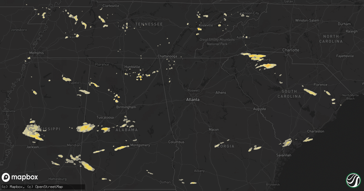
Hail Map in Tennessee on April 5, 2012
Get this storm
April 5 map
$229
one time, instant access
Download today. No call, no setup
Keep the $229
Bought the map and want the full workflow? Apply the entire $229 to a subscription within 7 days. None of it is wasted.
Every map, not just this one
This buys you this map. Subscription and you get every map we run, in the markets you choose from a few cities to whole states to nationwide. Plus real-time alerts the moment a storm fires.
Contact data
Name, contact info, occupancy, even credit band for addresses in the footprint. You go from where it hit to who to call.
Become the source they trust
Unlimited branding weather history reports on demand. You already have the documented answer ready for the property owner, and you are the one who showed up with it.
Property data and RoofTrace estimates
Pull up any address you have got, its value and the exact code rules for that jurisdiction, straight from One Click Code. Then RoofTrace estimates the squares, pitch, and roof value, priced the way you price.
Storm reports in Tennessee
Tennessee
| Date | Description |
|---|---|
| 04/05/20126:30 PM CDT | A local report indicates 1.50 inch wind near 3 S FARRAGUT |
| 04/05/20124:19 PM CDT | A local report indicates 1.00 inch wind near 2 NW UNICOI |
| 04/05/20123:49 PM CDT | Trees down on conklin rd. |
| 04/05/20123:18 PM CDT | A local report indicates 1.00 inch wind near 6 SE DUNLAP |
| 04/05/20123:10 PM CDT | Reported at mcewen post office |
| 04/05/20123:09 PM CDT | Hail reported along interstate 65 exit 73 in brentwood. |
| 04/05/20123:06 PM CDT | Powerlines down on horton highway. |
| 04/05/20123:00 PM CDT | Spotter reported quarter size hail near town square of centerville. |
| 04/05/20122:54 PM CDT | Trees down on welcome grove rd |
| 04/05/20121:40 PM CDT | Quarter sized hail on highway 22 bypass just north of huntingdon. |
| 04/05/20121:24 PM CDT | A local report indicates 1.00 inch wind near DEL RIO |
| 04/05/201212:57 PM CDT | A local report indicates 1.00 inch wind near 2 S LA FOLLETTE |
| 04/05/201212:10 PM CDT | A local report indicates 1.25 inch wind near LAKE CITY |
All States Impacted by Hail Map on April 5, 2012
Cities Impacted by Hail Map on April 5, 2012
- Brent, AL
- Murfreesboro, TN
- Portageville, MO
- Belden, MS
- Blue Springs, MS
- Ecru, MS
- Pontotoc, MS
- Tupelo, MS
- New Albany, MS
- Jasper, AL
- Empire, AL
- Sweet Water, AL
- Linden, AL
- Nauvoo, AL
- Brentwood, TN
- Pulaski, TN
- Aliceville, AL
- Huntingdon, TN
- Bruceton, TN
- Buena Vista, TN
- Canton, MS
- Chesnee, SC
- Spartanburg, SC
- Scottsboro, AL
- Hemingway, SC
- Cordova, AL
- Dora, AL
- Quinton, AL
- Briceville, TN
- Rocky Top, TN
- Andersonville, TN
- Clinton, TN
- Guntersville, AL
- Langston, AL
- Taylors, SC
- Campobello, SC
- Travelers Rest, SC
- Una, SC
- Marietta, SC
- Moore, SC
- Roebuck, SC
- Cowpens, SC
- Landrum, SC
- Startex, SC
- Wellford, SC
- Cleveland, SC
- Lyman, SC
- Duncan, SC
- Inman, SC
- Arcadia, SC
- Boiling Springs, SC
- Greer, SC
- Amory, MS
- Louisville, TN
- Soso, MS
- Laurel, MS
- Taylorsville, MS
- Nettleton, MS
- Benton, MS
- Waverly, TN
- McEwen, TN
- Martin, TN
- Jackson, TN
- Denmark, TN
- Orrville, AL
- Ridgeland, SC
- Hendersonville, NC
- Emelle, AL
- Fyffe, AL
- Gable, SC
- Olanta, SC
- Turbeville, SC
- Lake City, SC
- Mayesville, SC
- Lynchburg, SC
- Sumter, SC
- Section, AL
- Groveoak, AL
- Hamilton, AL
- Vina, AL
- Louin, MS
- Paulding, MS
- Bay Springs, MS
- Shubuta, MS
- Enoree, SC
- Union, SC
- Hackleburg, AL
- Haleyville, AL
- Bear Creek, AL
- Lyons, GA
- Seabrook, SC
- Hayti, MO
- Caruthersville, MO
- Charleston, MS
- Cascilla, MS
- Eutaw, AL
- Boligee, AL
- Kennett, MO
- Bragg City, MO
- Hayneville, AL
- Lowndesboro, AL
- Maynardville, TN
- Afton, TN
- Greeneville, TN
- Knoxville, TN
- Farragut, TN
- Lenoir City, TN
- Luray, TN
- Lexington, TN
- Huron, TN
- Beech Bluff, TN
- Henagar, AL
- Valley Head, AL
- Buffalo, SC
- Chester, SC
- Lockhart, SC
- Woodruff, SC
- Pauline, SC
- Jonesville, SC
- Sharon, SC
- Calera, AL
- Montevallo, AL
- Russellville, TN
- Whitesburg, TN
- Morristown, TN
- Westport, TN
- Greensboro, AL
- Moundville, AL
- Melvin, AL
- Quitman, MS
- Waynesboro, MS
- Gilbertown, AL
- Hawkinsville, GA
- Cochran, GA
- Sharon, TN
- Flora, MS
- Madison, MS
- Bentonia, MS
- Yazoo City, MS
- Brandon, MS
- Tinsley, MS
- Lexington, MS
- Sardis, AL
- Great Falls, SC
- Winnsboro, SC
- Blackstock, SC
- Holcomb, MO
- Rocky Face, GA
- Tunnel Hill, GA
- La Follette, TN
- Jacksboro, TN
- Vidalia, GA
- Somerville, AL
- Grant, AL
- Dresden, TN
- Thomaston, AL
- Greenback, TN
- Sevierville, TN
- Dandridge, TN
- Detroit, AL
- Sulligent, AL
- Claxton, GA
- Register, GA
- Cobbtown, GA
- Collins, GA
- Metter, GA
- Camilla, GA
- La Fayette, GA
- Newton, GA
- Pamplico, SC
- Johnsonville, SC
- Gresham, SC
- Decatur, AL
- Lake Cormorant, MS
- Hughes, AR
- Gleason, TN
- McKenzie, TN
- Powell, TN
- Rock Spring, GA
- Jonesborough, TN
- Unicoi, TN
- Greenwood Springs, MS
- Smithville, MS
- Union Grove, AL
- Randolph, AL
- Millry, AL
- Frankville, AL
- Jackson, AL
- Silas, AL
- Woodville, AL
- New Hope, AL
- Franklin, TN
- Oakdale, TN
- Harriman, TN
- Gideon, MO
- Aberdeen, MS
- Jemison, AL
- Albertville, AL
- Red Bay, AL
- Vossburg, MS
- Heidelberg, MS
- Lena, MS
- Selma, AL
- Tyler, AL
- Okatie, SC
- Beaufort, SC
- Hardeeville, SC
- Clanton, AL
- Nunnelly, TN
- Bon Aqua, TN
- Dickson, TN
- Edisto Island, SC
- Blakely, GA
- Mize, MS
- Oxford, MS
- Taylor, MS
- Chickamauga, GA
- Ringgold, GA
- Tchula, MS
- Swannanoa, NC
- Asheville, NC
- Shelby, AL
- Rembert, SC
- Camden, SC
- Dalzell, SC
- Arab, AL
- Greenfield, TN
- Alabaster, AL
- Old Fort, TN
- Cleveland, TN
- Bulls Gap, TN
- Damascus, GA
- Moulton, AL
- Rome, GA
- Fountain Inn, SC
- Gray Court, SC
- Carlisle, SC
- Columbia, TN
- Centreville, AL
- Vaughan, MS
- Newport, TN
- Scooba, MS
- Epes, AL
- Gainesville, AL
- Pickens, MS
- Pikeville, TN
- Murrells Inlet, SC
- Thompsons Station, TN
- College Grove, TN
- Huntsville, AL
- Owens Cross Roads, AL
- Johns Island, SC
- Myrtle, MS
- Dover, TN
- Cumberland City, TN
- Akron, AL
- Marion, AL
- Union City, TN
- Colquitt, GA
- Sylvania, AL
- Fort Payne, AL
- Prattville, AL
- Deatsville, AL
- Coffeeville, AL
- Saint Stephens, AL
- Uriah, AL
- Gruetli Laager, TN
- Trezevant, TN
- Atwood, TN
- Loudon, TN
- Ridgeland, MS
- Auburntown, TN
- Milton, TN
- Shuqualak, MS
- Macon, MS
- Rossville, GA
- Flintstone, GA
- Sledge, MS
- Cosby, TN
- Graysville, TN
- Sawyerville, AL
- Camden, MS
- Kosciusko, MS
- Campbell, MO
- Parrish, AL
- Glendale, SC
- Gaffney, SC
- Indian Mound, TN
- Estillfork, AL
- Rainsville, AL
- Cumberland Furnace, TN
- Vanleer, TN
- Dudley, GA
- Neelyville, MO
- Goodman, MS
- Holladay, TN
- Thorsby, AL
- Glenwood, AL
- Troy, AL
- Autaugaville, AL
- Tutwiler, MS
- Charlotte, TN
- Heiskell, TN
- Laceys Spring, AL
- Jack, AL
- Elba, AL
- New Brockton, AL
- Enterprise, AL
- Palmer, TN
- Limestone, TN
- Atmore, AL
- Farmerville, LA
- Knoxville, AL
- Weaverville, NC
- Paris, TN
- De Kalb, MS
- Preston, MS
- Blair, SC
- Bells, TN
- Humboldt, TN
- Telford, TN
- Plantersville, MS
- Bremen, AL
- Huntland, TN
- Medina, TN
- Milan, TN
- Springfield, GA
- Crandall, GA
- Chester, GA
- Magnolia, AL
- Fairview, TN
- Rives, TN


