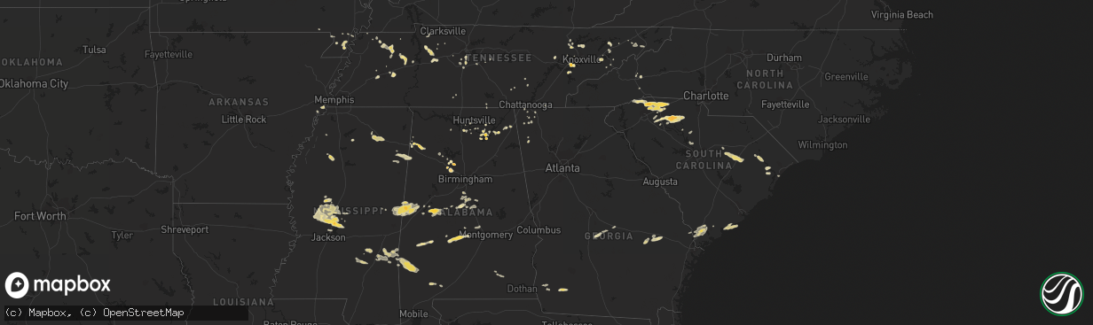
Hail Map in Mississippi on April 5, 2012
The weather event in Mississippi on April 5, 2012 includes Hail map. 9 states and 332 cities were impacted and suffered possible damage. The total estimated number of properties impacted is 0.
Want more than just the map?
Turn this storm into a full workflow.
- Owner + property data so you know who to knock
- OnDemand branded weather history reports to win the "did we even have hail?" argument
- RoofTrace estimate so reps stop guessing numbers at the door
Bought this map? Upgrade within 7 days and we'll credit the $230. (10-15 min setup call)
Hail
0
Estimated number of impacted properties by a 1.00" hail or larger0
Estimated number of impacted properties by a 1.75" hail or larger0
Estimated number of impacted properties by a 2.50" hail or largerStorm reports in Mississippi
Mississippi
| Date | Description |
|---|---|
| 04/05/20124:01 PM CDT | Quarter sized hail near the community of parham. |
| 04/05/20123:40 PM CDT | 3 trees down near shannon reported by wtva weather. |
| 04/05/20123:25 PM CDT | Couple of trees down in area around heidelberg. Also had reports of hail of unknown size. |
| 04/05/20123:00 PM CDT | Quarter sized hail near ecru. |
| 04/05/201211:20 AM CDT | Pea to penny sized hail...with a few quarter sized hailstones |
| 04/05/201210:27 AM CDT | A local report indicates 1.00 inch wind near 5 W QUITMAN |
| 04/05/201210:25 AM CDT | Couple of trees down in area around heidelberg. Also had reports of hail of unknown size. |
| 04/05/20127:49 AM CDT | 1 mile north of nissan blvd |
| 04/05/20127:45 AM CDT | Large hail falling on mdot traffic cam at nissan parkway |
| 04/05/20127:37 AM CDT | A local report indicates 1.00 inch wind near 6 WNW CANTON |
| 04/05/20127:27 AM CDT | A local report indicates 1.00 inch wind near BENTON |
| 04/05/20127:27 AM CDT | 1 mile north of nissan blvd |
| 04/05/20127:15 AM CDT | Hail covered the ground |
| 04/05/20127:15 AM CDT | Trees down on midway gin road |
| 04/05/20127:12 AM CDT | Tree down on a powerline at lakeshore drive |
All States Impacted by Hail Map on April 5, 2012
Cities Impacted by Hail Map on April 5, 2012
- Brent, AL
- Murfreesboro, TN
- Portageville, MO
- Belden, MS
- Blue Springs, MS
- Ecru, MS
- Pontotoc, MS
- Tupelo, MS
- New Albany, MS
- Jasper, AL
- Empire, AL
- Sweet Water, AL
- Linden, AL
- Nauvoo, AL
- Brentwood, TN
- Pulaski, TN
- Aliceville, AL
- Huntingdon, TN
- Bruceton, TN
- Buena Vista, TN
- Canton, MS
- Chesnee, SC
- Spartanburg, SC
- Scottsboro, AL
- Hemingway, SC
- Cordova, AL
- Dora, AL
- Quinton, AL
- Briceville, TN
- Rocky Top, TN
- Andersonville, TN
- Clinton, TN
- Guntersville, AL
- Langston, AL
- Taylors, SC
- Campobello, SC
- Travelers Rest, SC
- Una, SC
- Marietta, SC
- Moore, SC
- Roebuck, SC
- Cowpens, SC
- Landrum, SC
- Startex, SC
- Wellford, SC
- Cleveland, SC
- Lyman, SC
- Duncan, SC
- Inman, SC
- Arcadia, SC
- Boiling Springs, SC
- Greer, SC
- Amory, MS
- Louisville, TN
- Soso, MS
- Laurel, MS
- Taylorsville, MS
- Nettleton, MS
- Benton, MS
- Waverly, TN
- McEwen, TN
- Martin, TN
- Jackson, TN
- Denmark, TN
- Orrville, AL
- Ridgeland, SC
- Hendersonville, NC
- Emelle, AL
- Fyffe, AL
- Gable, SC
- Olanta, SC
- Turbeville, SC
- Lake City, SC
- Mayesville, SC
- Lynchburg, SC
- Sumter, SC
- Section, AL
- Groveoak, AL
- Hamilton, AL
- Vina, AL
- Louin, MS
- Paulding, MS
- Bay Springs, MS
- Shubuta, MS
- Enoree, SC
- Union, SC
- Hackleburg, AL
- Haleyville, AL
- Bear Creek, AL
- Lyons, GA
- Seabrook, SC
- Hayti, MO
- Caruthersville, MO
- Charleston, MS
- Cascilla, MS
- Eutaw, AL
- Boligee, AL
- Kennett, MO
- Bragg City, MO
- Hayneville, AL
- Lowndesboro, AL
- Maynardville, TN
- Afton, TN
- Greeneville, TN
- Knoxville, TN
- Farragut, TN
- Lenoir City, TN
- Luray, TN
- Lexington, TN
- Huron, TN
- Beech Bluff, TN
- Henagar, AL
- Valley Head, AL
- Buffalo, SC
- Chester, SC
- Lockhart, SC
- Woodruff, SC
- Pauline, SC
- Jonesville, SC
- Sharon, SC
- Calera, AL
- Montevallo, AL
- Russellville, TN
- Whitesburg, TN
- Morristown, TN
- Westport, TN
- Greensboro, AL
- Moundville, AL
- Melvin, AL
- Quitman, MS
- Waynesboro, MS
- Gilbertown, AL
- Hawkinsville, GA
- Cochran, GA
- Sharon, TN
- Flora, MS
- Madison, MS
- Bentonia, MS
- Yazoo City, MS
- Brandon, MS
- Tinsley, MS
- Lexington, MS
- Sardis, AL
- Great Falls, SC
- Winnsboro, SC
- Blackstock, SC
- Holcomb, MO
- Rocky Face, GA
- Tunnel Hill, GA
- La Follette, TN
- Jacksboro, TN
- Vidalia, GA
- Somerville, AL
- Grant, AL
- Dresden, TN
- Thomaston, AL
- Greenback, TN
- Sevierville, TN
- Dandridge, TN
- Detroit, AL
- Sulligent, AL
- Claxton, GA
- Register, GA
- Cobbtown, GA
- Collins, GA
- Metter, GA
- Camilla, GA
- La Fayette, GA
- Newton, GA
- Pamplico, SC
- Johnsonville, SC
- Gresham, SC
- Decatur, AL
- Lake Cormorant, MS
- Hughes, AR
- Gleason, TN
- McKenzie, TN
- Powell, TN
- Rock Spring, GA
- Jonesborough, TN
- Unicoi, TN
- Greenwood Springs, MS
- Smithville, MS
- Union Grove, AL
- Randolph, AL
- Millry, AL
- Frankville, AL
- Jackson, AL
- Silas, AL
- Woodville, AL
- New Hope, AL
- Franklin, TN
- Oakdale, TN
- Harriman, TN
- Gideon, MO
- Aberdeen, MS
- Jemison, AL
- Albertville, AL
- Red Bay, AL
- Vossburg, MS
- Heidelberg, MS
- Lena, MS
- Selma, AL
- Tyler, AL
- Okatie, SC
- Beaufort, SC
- Hardeeville, SC
- Clanton, AL
- Nunnelly, TN
- Bon Aqua, TN
- Dickson, TN
- Edisto Island, SC
- Blakely, GA
- Mize, MS
- Oxford, MS
- Taylor, MS
- Chickamauga, GA
- Ringgold, GA
- Tchula, MS
- Swannanoa, NC
- Asheville, NC
- Shelby, AL
- Rembert, SC
- Camden, SC
- Dalzell, SC
- Arab, AL
- Greenfield, TN
- Alabaster, AL
- Old Fort, TN
- Cleveland, TN
- Bulls Gap, TN
- Damascus, GA
- Moulton, AL
- Rome, GA
- Fountain Inn, SC
- Gray Court, SC
- Carlisle, SC
- Columbia, TN
- Centreville, AL
- Vaughan, MS
- Newport, TN
- Scooba, MS
- Epes, AL
- Gainesville, AL
- Pickens, MS
- Pikeville, TN
- Murrells Inlet, SC
- Thompsons Station, TN
- College Grove, TN
- Huntsville, AL
- Owens Cross Roads, AL
- Johns Island, SC
- Myrtle, MS
- Dover, TN
- Cumberland City, TN
- Akron, AL
- Marion, AL
- Union City, TN
- Colquitt, GA
- Sylvania, AL
- Fort Payne, AL
- Prattville, AL
- Deatsville, AL
- Coffeeville, AL
- Saint Stephens, AL
- Uriah, AL
- Gruetli Laager, TN
- Trezevant, TN
- Atwood, TN
- Loudon, TN
- Ridgeland, MS
- Auburntown, TN
- Milton, TN
- Shuqualak, MS
- Macon, MS
- Rossville, GA
- Flintstone, GA
- Sledge, MS
- Cosby, TN
- Graysville, TN
- Sawyerville, AL
- Camden, MS
- Kosciusko, MS
- Campbell, MO
- Parrish, AL
- Glendale, SC
- Gaffney, SC
- Indian Mound, TN
- Estillfork, AL
- Rainsville, AL
- Cumberland Furnace, TN
- Vanleer, TN
- Dudley, GA
- Neelyville, MO
- Goodman, MS
- Holladay, TN
- Thorsby, AL
- Glenwood, AL
- Troy, AL
- Autaugaville, AL
- Tutwiler, MS
- Charlotte, TN
- Heiskell, TN
- Laceys Spring, AL
- Jack, AL
- Elba, AL
- New Brockton, AL
- Enterprise, AL
- Palmer, TN
- Limestone, TN
- Atmore, AL
- Farmerville, LA
- Knoxville, AL
- Weaverville, NC
- Paris, TN
- De Kalb, MS
- Preston, MS
- Blair, SC
- Bells, TN
- Humboldt, TN
- Telford, TN
- Plantersville, MS
- Bremen, AL
- Huntland, TN
- Medina, TN
- Milan, TN
- Springfield, GA
- Crandall, GA
- Chester, GA
- Magnolia, AL
- Fairview, TN
- Rives, TN


