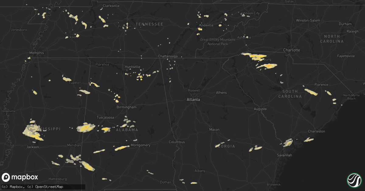
Hail Map in South Carolina on April 5, 2012
Get this storm
April 5 map
$229
one time, instant access
Download today. No call, no setup
Keep the $229
Bought the map and want the full workflow? Apply the entire $229 to a subscription within 7 days. None of it is wasted.
Every map, not just this one
This buys you this map. Subscription and you get every map we run, in the markets you choose from a few cities to whole states to nationwide. Plus real-time alerts the moment a storm fires.
Contact data
Name, contact info, occupancy, even credit band for addresses in the footprint. You go from where it hit to who to call.
Become the source they trust
Unlimited branding weather history reports on demand. You already have the documented answer ready for the property owner, and you are the one who showed up with it.
Property data and RoofTrace estimates
Pull up any address you have got, its value and the exact code rules for that jurisdiction, straight from One Click Code. Then RoofTrace estimates the squares, pitch, and roof value, priced the way you price.
Storm reports in South Carolina
South Carolina
| Date | Description |
|---|---|
| 04/05/20126:19 PM CDT | Multiple trees down in the green pond area. Time estimated from radar. |
| 04/05/20125:51 PM CDT | 3 to 4 tress down in the sheldon area. Time based on radar. |
| 04/05/20124:15 PM CDT | Tree down along carolina country club and pioneer fish camp rd. |
| 04/05/20124:12 PM CDT | A local report indicates 1.75 inch wind near UNION |
| 04/05/20124:07 PM CDT | Tree down along e pine and s main st...rptd by schp. |
| 04/05/20124:00 PM CDT | A local report indicates 1.00 inch wind near LOCKHART |
| 04/05/20123:58 PM CDT | A local report indicates 1.25 inch wind near DUNCAN |
| 04/05/20123:56 PM CDT | Up to 1 inch hail reported by spotter in duncan. |
| 04/05/20123:44 PM CDT | A local report indicates 1.00 inch wind near UNION |
| 04/05/20123:40 PM CDT | Observed at peach valley country club |
| 04/05/20123:36 PM CDT | Lake blalock park ranger observed quarter sized hail. Time determined by radar. |
| 04/05/20123:35 PM CDT | Power lines down...hanging rock rd and old furnace rd. |
| 04/05/20123:33 PM CDT | Up to 1 inch hail reported right next to greer high school. |
| 04/05/20123:32 PM CDT | Tree down along cherry hill rd and school drive. |
| 04/05/20123:32 PM CDT | Cherokee springs fd reported up to ping pong ball sized hail and some tree branches down. |
| 04/05/20123:30 PM CDT | Hail covered the ground at bonham fd |
| 04/05/20123:14 PM CDT | Boiling springs fd reported up to 1 inch hail at the station. |
| 04/05/20122:50 PM CDT | A local report indicates 1.25 inch wind near 3 W INMAN |
| 04/05/20122:36 PM CDT | Public reported trees down across i-95 near mile marker 135. |
| 04/05/20122:35 PM CDT | Public reported quarter size hail damaged their windshield near mile marker 135 on i-95. |
| 04/05/20122:30 PM CDT | Mainly nickel size with some quarter-size hailstones observed |
| 04/05/20122:28 PM CDT | A local report indicates 1.75 inch wind near 4 SSW GOWENSVILLE |
| 04/05/20122:27 PM CDT | Tree on residence along camp creek rd. |
| 04/05/20122:25 PM CDT | Cockrell rd |
| 04/05/20122:20 PM CDT | Clarendon county fire dept. Reported quarter size hail on southbound i-95 |
| 04/05/20122:18 PM CDT | A local report indicates 1.00 inch wind near 1 SE WOODRUFF |
| 04/05/20122:14 PM CDT | A local report indicates 1.00 inch wind near 2 E PAMPLICO |
| 04/05/20122:12 PM CDT | Public reported quarter size hail covering the ground and the hail damaged plants and garden. |
| 04/05/20121:30 PM CDT | Quarter sized hail almost covered the ground |
| 04/04/20127:13 PM CDT | One large tree down in taylor plantation. |
| 04/04/20127:11 PM CDT | Wind gust to 60 mph estimated by a trained spotter at the intersection of ladson and dorchester roads. |
All States Impacted by Hail Map on April 5, 2012
Cities Impacted by Hail Map on April 5, 2012
- Brent, AL
- Murfreesboro, TN
- Portageville, MO
- Belden, MS
- Blue Springs, MS
- Ecru, MS
- Pontotoc, MS
- Tupelo, MS
- New Albany, MS
- Jasper, AL
- Empire, AL
- Sweet Water, AL
- Linden, AL
- Nauvoo, AL
- Brentwood, TN
- Pulaski, TN
- Aliceville, AL
- Huntingdon, TN
- Bruceton, TN
- Buena Vista, TN
- Canton, MS
- Chesnee, SC
- Spartanburg, SC
- Scottsboro, AL
- Hemingway, SC
- Cordova, AL
- Dora, AL
- Quinton, AL
- Briceville, TN
- Rocky Top, TN
- Andersonville, TN
- Clinton, TN
- Guntersville, AL
- Langston, AL
- Taylors, SC
- Campobello, SC
- Travelers Rest, SC
- Una, SC
- Marietta, SC
- Moore, SC
- Roebuck, SC
- Cowpens, SC
- Landrum, SC
- Startex, SC
- Wellford, SC
- Cleveland, SC
- Lyman, SC
- Duncan, SC
- Inman, SC
- Arcadia, SC
- Boiling Springs, SC
- Greer, SC
- Amory, MS
- Louisville, TN
- Soso, MS
- Laurel, MS
- Taylorsville, MS
- Nettleton, MS
- Benton, MS
- Waverly, TN
- McEwen, TN
- Martin, TN
- Jackson, TN
- Denmark, TN
- Orrville, AL
- Ridgeland, SC
- Hendersonville, NC
- Emelle, AL
- Fyffe, AL
- Gable, SC
- Olanta, SC
- Turbeville, SC
- Lake City, SC
- Mayesville, SC
- Lynchburg, SC
- Sumter, SC
- Section, AL
- Groveoak, AL
- Hamilton, AL
- Vina, AL
- Louin, MS
- Paulding, MS
- Bay Springs, MS
- Shubuta, MS
- Enoree, SC
- Union, SC
- Hackleburg, AL
- Haleyville, AL
- Bear Creek, AL
- Lyons, GA
- Seabrook, SC
- Hayti, MO
- Caruthersville, MO
- Charleston, MS
- Cascilla, MS
- Eutaw, AL
- Boligee, AL
- Kennett, MO
- Bragg City, MO
- Hayneville, AL
- Lowndesboro, AL
- Maynardville, TN
- Afton, TN
- Greeneville, TN
- Knoxville, TN
- Farragut, TN
- Lenoir City, TN
- Luray, TN
- Lexington, TN
- Huron, TN
- Beech Bluff, TN
- Henagar, AL
- Valley Head, AL
- Buffalo, SC
- Chester, SC
- Lockhart, SC
- Woodruff, SC
- Pauline, SC
- Jonesville, SC
- Sharon, SC
- Calera, AL
- Montevallo, AL
- Russellville, TN
- Whitesburg, TN
- Morristown, TN
- Westport, TN
- Greensboro, AL
- Moundville, AL
- Melvin, AL
- Quitman, MS
- Waynesboro, MS
- Gilbertown, AL
- Hawkinsville, GA
- Cochran, GA
- Sharon, TN
- Flora, MS
- Madison, MS
- Bentonia, MS
- Yazoo City, MS
- Brandon, MS
- Tinsley, MS
- Lexington, MS
- Sardis, AL
- Great Falls, SC
- Winnsboro, SC
- Blackstock, SC
- Holcomb, MO
- Rocky Face, GA
- Tunnel Hill, GA
- La Follette, TN
- Jacksboro, TN
- Vidalia, GA
- Somerville, AL
- Grant, AL
- Dresden, TN
- Thomaston, AL
- Greenback, TN
- Sevierville, TN
- Dandridge, TN
- Detroit, AL
- Sulligent, AL
- Claxton, GA
- Register, GA
- Cobbtown, GA
- Collins, GA
- Metter, GA
- Camilla, GA
- La Fayette, GA
- Newton, GA
- Pamplico, SC
- Johnsonville, SC
- Gresham, SC
- Decatur, AL
- Lake Cormorant, MS
- Hughes, AR
- Gleason, TN
- McKenzie, TN
- Powell, TN
- Rock Spring, GA
- Jonesborough, TN
- Unicoi, TN
- Greenwood Springs, MS
- Smithville, MS
- Union Grove, AL
- Randolph, AL
- Millry, AL
- Frankville, AL
- Jackson, AL
- Silas, AL
- Woodville, AL
- New Hope, AL
- Franklin, TN
- Oakdale, TN
- Harriman, TN
- Gideon, MO
- Aberdeen, MS
- Jemison, AL
- Albertville, AL
- Red Bay, AL
- Vossburg, MS
- Heidelberg, MS
- Lena, MS
- Selma, AL
- Tyler, AL
- Okatie, SC
- Beaufort, SC
- Hardeeville, SC
- Clanton, AL
- Nunnelly, TN
- Bon Aqua, TN
- Dickson, TN
- Edisto Island, SC
- Blakely, GA
- Mize, MS
- Oxford, MS
- Taylor, MS
- Chickamauga, GA
- Ringgold, GA
- Tchula, MS
- Swannanoa, NC
- Asheville, NC
- Shelby, AL
- Rembert, SC
- Camden, SC
- Dalzell, SC
- Arab, AL
- Greenfield, TN
- Alabaster, AL
- Old Fort, TN
- Cleveland, TN
- Bulls Gap, TN
- Damascus, GA
- Moulton, AL
- Rome, GA
- Fountain Inn, SC
- Gray Court, SC
- Carlisle, SC
- Columbia, TN
- Centreville, AL
- Vaughan, MS
- Newport, TN
- Scooba, MS
- Epes, AL
- Gainesville, AL
- Pickens, MS
- Pikeville, TN
- Murrells Inlet, SC
- Thompsons Station, TN
- College Grove, TN
- Huntsville, AL
- Owens Cross Roads, AL
- Johns Island, SC
- Myrtle, MS
- Dover, TN
- Cumberland City, TN
- Akron, AL
- Marion, AL
- Union City, TN
- Colquitt, GA
- Sylvania, AL
- Fort Payne, AL
- Prattville, AL
- Deatsville, AL
- Coffeeville, AL
- Saint Stephens, AL
- Uriah, AL
- Gruetli Laager, TN
- Trezevant, TN
- Atwood, TN
- Loudon, TN
- Ridgeland, MS
- Auburntown, TN
- Milton, TN
- Shuqualak, MS
- Macon, MS
- Rossville, GA
- Flintstone, GA
- Sledge, MS
- Cosby, TN
- Graysville, TN
- Sawyerville, AL
- Camden, MS
- Kosciusko, MS
- Campbell, MO
- Parrish, AL
- Glendale, SC
- Gaffney, SC
- Indian Mound, TN
- Estillfork, AL
- Rainsville, AL
- Cumberland Furnace, TN
- Vanleer, TN
- Dudley, GA
- Neelyville, MO
- Goodman, MS
- Holladay, TN
- Thorsby, AL
- Glenwood, AL
- Troy, AL
- Autaugaville, AL
- Tutwiler, MS
- Charlotte, TN
- Heiskell, TN
- Laceys Spring, AL
- Jack, AL
- Elba, AL
- New Brockton, AL
- Enterprise, AL
- Palmer, TN
- Limestone, TN
- Atmore, AL
- Farmerville, LA
- Knoxville, AL
- Weaverville, NC
- Paris, TN
- De Kalb, MS
- Preston, MS
- Blair, SC
- Bells, TN
- Humboldt, TN
- Telford, TN
- Plantersville, MS
- Bremen, AL
- Huntland, TN
- Medina, TN
- Milan, TN
- Springfield, GA
- Crandall, GA
- Chester, GA
- Magnolia, AL
- Fairview, TN
- Rives, TN


