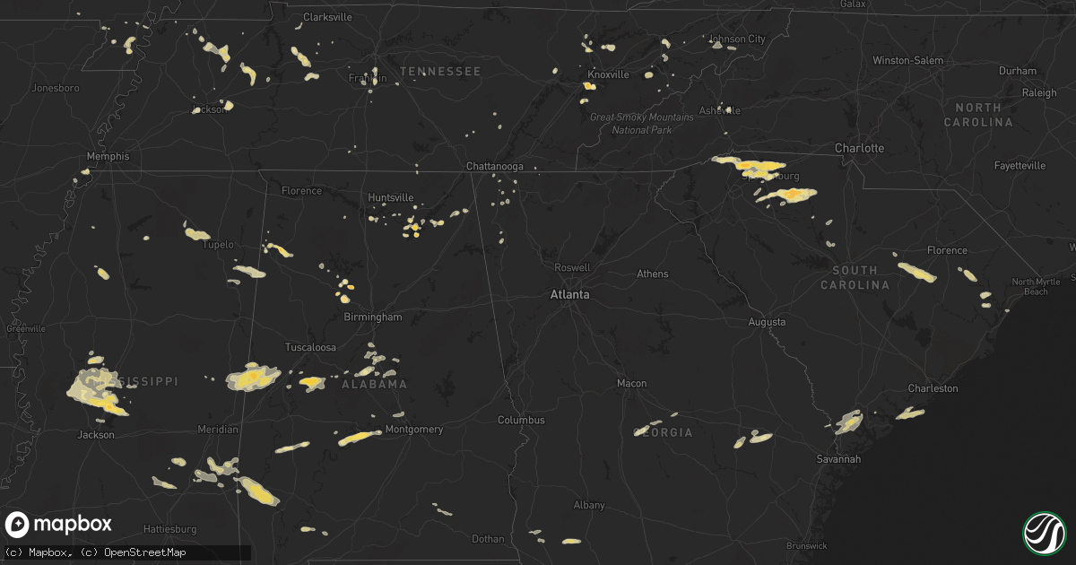
Hail Map in Alabama on April 5, 2012
Get this storm
April 5 map
$229
one time, instant access
Download today. No call, no setup
Keep the $229
Bought the map and want the full workflow? Apply the entire $229 to a subscription within 7 days. None of it is wasted.
Every map, not just this one
This buys you this map. Subscription and you get every map we run, in the markets you choose from a few cities to whole states to nationwide. Plus real-time alerts the moment a storm fires.
Contact data
Name, contact info, occupancy, even credit band for addresses in the footprint. You go from where it hit to who to call.
Become the source they trust
Unlimited branding weather history reports on demand. You already have the documented answer ready for the property owner, and you are the one who showed up with it.
Property data and RoofTrace estimates
Pull up any address you have got, its value and the exact code rules for that jurisdiction, straight from One Click Code. Then RoofTrace estimates the squares, pitch, and roof value, priced the way you price.
Storm reports in Alabama
Alabama
| Date | Description |
|---|---|
| 04/05/20126:59 PM CDT | Quarter hail in and around calera. |
| 04/05/20126:56 PM CDT | Quarter hail and winds estimated at 60 mph near interstate 65 at exit 219. |
| 04/05/20126:55 PM CDT | Atop red mountain |
| 04/05/20126:48 PM CDT | Quarter size hail at the nws office. |
| 04/05/20126:47 PM CDT | Half dollar size hail just west of jemison on county rd 42. |
| 04/05/20126:46 PM CDT | A local report indicates 1.00 inch wind near FULTONDALE |
| 04/05/20126:46 PM CDT | A local report indicates 1.00 inch wind near ALABASTER |
| 04/05/20126:43 PM CDT | Dime to quarter sized hail was reported on georgia mountain west of guntersville. |
| 04/05/20126:38 PM CDT | A few trees were blown down around gardendale. |
| 04/05/20126:32 PM CDT | Golf ball sized hail reported south of sardis |
| 04/05/20126:19 PM CDT | A few trees were blown down near adamsville. |
| 04/05/20125:49 PM CDT | Ping pong ball size hail reported just east of cordova. |
| 04/05/20125:46 PM CDT | Golf ball size hail in cordova. |
| 04/05/20125:37 PM CDT | Quarter size hail in poplar springs. |
| 04/05/20125:31 PM CDT | Picture sent in with hail covering the ground east of jasper. |
| 04/05/20125:07 PM CDT | Several trees and power lines were blown down in and around fayette. A few were blocking roadways. |
| 04/05/20124:54 PM CDT | Tree and power lines down on a house on 3rd avenue in guin. |
| 04/05/20124:43 PM CDT | Ping pong ball size hail 6 miles north of hamilton. |
| 04/05/20124:40 PM CDT | Two trees down in vernon. |
| 04/05/20124:34 PM CDT | Several trees were knocked down in vernon |
| 04/05/20124:28 PM CDT | Quarter size hail in the pine springs community. |
| 04/05/20124:25 PM CDT | Several trees were knocked down in and around sulligent. |
| 04/05/20123:51 PM CDT | One tree down in the southbound lane of us-431 just north of abbeville. |
| 04/05/20123:34 PM CDT | Trees down around midland city |
| 04/05/20123:29 PM CDT | Trees down around echo |
| 04/05/20123:29 PM CDT | Trees down around browns crossroads |
| 04/05/20123:25 PM CDT | A few trees reported down in eastern dale county. |
| 04/05/20123:16 PM CDT | Emergency manager reported a measured wind gust of 51 knots at 316 pm ct in ozark. |
| 04/05/20123:07 PM CDT | Trees down around marley hill |
| 04/05/20122:42 PM CDT | A couple of power poles knocked down between cr 87 and cr 167 in northern coffee county. Time estimated by radar. |
| 04/05/201212:05 PM CDT | Tree reported down near selma and pea sized hail reported by county deputies |
| 04/05/201211:37 AM CDT | Several trees reported down by perry county highway dept. Near the intersection of buster sealy road and highway 183 |
| 04/05/201210:58 AM CDT | Golf ball sized hail reported in havana. |
| 04/05/201210:12 AM CDT | Tree reported down on alabama highway 39 about 2 miles northeast of gainesville. |
| 04/05/201210:05 AM CDT | Ping pong ball sized hail reported in panola. |
| 04/04/20127:53 PM CDT | A local report indicates 1.00 inch wind near MENTONE |
| 04/04/20127:45 PM CDT | Small tree was reported down across mercer road. |
| 04/04/20127:39 PM CDT | A few trees were blown down near talladega. |
| 04/04/20127:25 PM CDT | Quarter hail in sylvania. |
| 04/04/20127:20 PM CDT | Golf ball and quarter size hail reported along hwy 431 just west of columbus city. |
| 04/04/20127:20 PM CDT | A few trees were blown down in the vicinity of vincent. |
| 04/04/20127:20 PM CDT | Numerous trees down in the wolf creek area. |
| 04/04/20127:14 PM CDT | Quarter hail and winds estimated at 60 mph near interstate 65 at exit 219. |
| 04/04/20127:10 PM CDT | Public call to wsfa tv in montgomery. |
All States Impacted by Hail Map on April 5, 2012
Cities Impacted by Hail Map on April 5, 2012
- Brent, AL
- Murfreesboro, TN
- Portageville, MO
- Belden, MS
- Blue Springs, MS
- Ecru, MS
- Pontotoc, MS
- Tupelo, MS
- New Albany, MS
- Jasper, AL
- Empire, AL
- Sweet Water, AL
- Linden, AL
- Nauvoo, AL
- Brentwood, TN
- Pulaski, TN
- Aliceville, AL
- Huntingdon, TN
- Bruceton, TN
- Buena Vista, TN
- Canton, MS
- Chesnee, SC
- Spartanburg, SC
- Scottsboro, AL
- Hemingway, SC
- Cordova, AL
- Dora, AL
- Quinton, AL
- Briceville, TN
- Rocky Top, TN
- Andersonville, TN
- Clinton, TN
- Guntersville, AL
- Langston, AL
- Taylors, SC
- Campobello, SC
- Travelers Rest, SC
- Una, SC
- Marietta, SC
- Moore, SC
- Roebuck, SC
- Cowpens, SC
- Landrum, SC
- Startex, SC
- Wellford, SC
- Cleveland, SC
- Lyman, SC
- Duncan, SC
- Inman, SC
- Arcadia, SC
- Boiling Springs, SC
- Greer, SC
- Amory, MS
- Louisville, TN
- Soso, MS
- Laurel, MS
- Taylorsville, MS
- Nettleton, MS
- Benton, MS
- Waverly, TN
- McEwen, TN
- Martin, TN
- Jackson, TN
- Denmark, TN
- Orrville, AL
- Ridgeland, SC
- Hendersonville, NC
- Emelle, AL
- Fyffe, AL
- Gable, SC
- Olanta, SC
- Turbeville, SC
- Lake City, SC
- Mayesville, SC
- Lynchburg, SC
- Sumter, SC
- Section, AL
- Groveoak, AL
- Hamilton, AL
- Vina, AL
- Louin, MS
- Paulding, MS
- Bay Springs, MS
- Shubuta, MS
- Enoree, SC
- Union, SC
- Hackleburg, AL
- Haleyville, AL
- Bear Creek, AL
- Lyons, GA
- Seabrook, SC
- Hayti, MO
- Caruthersville, MO
- Charleston, MS
- Cascilla, MS
- Eutaw, AL
- Boligee, AL
- Kennett, MO
- Bragg City, MO
- Hayneville, AL
- Lowndesboro, AL
- Maynardville, TN
- Afton, TN
- Greeneville, TN
- Knoxville, TN
- Farragut, TN
- Lenoir City, TN
- Luray, TN
- Lexington, TN
- Huron, TN
- Beech Bluff, TN
- Henagar, AL
- Valley Head, AL
- Buffalo, SC
- Chester, SC
- Lockhart, SC
- Woodruff, SC
- Pauline, SC
- Jonesville, SC
- Sharon, SC
- Calera, AL
- Montevallo, AL
- Russellville, TN
- Whitesburg, TN
- Morristown, TN
- Westport, TN
- Greensboro, AL
- Moundville, AL
- Melvin, AL
- Quitman, MS
- Waynesboro, MS
- Gilbertown, AL
- Hawkinsville, GA
- Cochran, GA
- Sharon, TN
- Flora, MS
- Madison, MS
- Bentonia, MS
- Yazoo City, MS
- Brandon, MS
- Tinsley, MS
- Lexington, MS
- Sardis, AL
- Great Falls, SC
- Winnsboro, SC
- Blackstock, SC
- Holcomb, MO
- Rocky Face, GA
- Tunnel Hill, GA
- La Follette, TN
- Jacksboro, TN
- Vidalia, GA
- Somerville, AL
- Grant, AL
- Dresden, TN
- Thomaston, AL
- Greenback, TN
- Sevierville, TN
- Dandridge, TN
- Detroit, AL
- Sulligent, AL
- Claxton, GA
- Register, GA
- Cobbtown, GA
- Collins, GA
- Metter, GA
- Camilla, GA
- La Fayette, GA
- Newton, GA
- Pamplico, SC
- Johnsonville, SC
- Gresham, SC
- Decatur, AL
- Lake Cormorant, MS
- Hughes, AR
- Gleason, TN
- McKenzie, TN
- Powell, TN
- Rock Spring, GA
- Jonesborough, TN
- Unicoi, TN
- Greenwood Springs, MS
- Smithville, MS
- Union Grove, AL
- Randolph, AL
- Millry, AL
- Frankville, AL
- Jackson, AL
- Silas, AL
- Woodville, AL
- New Hope, AL
- Franklin, TN
- Oakdale, TN
- Harriman, TN
- Gideon, MO
- Aberdeen, MS
- Jemison, AL
- Albertville, AL
- Red Bay, AL
- Vossburg, MS
- Heidelberg, MS
- Lena, MS
- Selma, AL
- Tyler, AL
- Okatie, SC
- Beaufort, SC
- Hardeeville, SC
- Clanton, AL
- Nunnelly, TN
- Bon Aqua, TN
- Dickson, TN
- Edisto Island, SC
- Blakely, GA
- Mize, MS
- Oxford, MS
- Taylor, MS
- Chickamauga, GA
- Ringgold, GA
- Tchula, MS
- Swannanoa, NC
- Asheville, NC
- Shelby, AL
- Rembert, SC
- Camden, SC
- Dalzell, SC
- Arab, AL
- Greenfield, TN
- Alabaster, AL
- Old Fort, TN
- Cleveland, TN
- Bulls Gap, TN
- Damascus, GA
- Moulton, AL
- Rome, GA
- Fountain Inn, SC
- Gray Court, SC
- Carlisle, SC
- Columbia, TN
- Centreville, AL
- Vaughan, MS
- Newport, TN
- Scooba, MS
- Epes, AL
- Gainesville, AL
- Pickens, MS
- Pikeville, TN
- Murrells Inlet, SC
- Thompsons Station, TN
- College Grove, TN
- Huntsville, AL
- Owens Cross Roads, AL
- Johns Island, SC
- Myrtle, MS
- Dover, TN
- Cumberland City, TN
- Akron, AL
- Marion, AL
- Union City, TN
- Colquitt, GA
- Sylvania, AL
- Fort Payne, AL
- Prattville, AL
- Deatsville, AL
- Coffeeville, AL
- Saint Stephens, AL
- Uriah, AL
- Gruetli Laager, TN
- Trezevant, TN
- Atwood, TN
- Loudon, TN
- Ridgeland, MS
- Auburntown, TN
- Milton, TN
- Shuqualak, MS
- Macon, MS
- Rossville, GA
- Flintstone, GA
- Sledge, MS
- Cosby, TN
- Graysville, TN
- Sawyerville, AL
- Camden, MS
- Kosciusko, MS
- Campbell, MO
- Parrish, AL
- Glendale, SC
- Gaffney, SC
- Indian Mound, TN
- Estillfork, AL
- Rainsville, AL
- Cumberland Furnace, TN
- Vanleer, TN
- Dudley, GA
- Neelyville, MO
- Goodman, MS
- Holladay, TN
- Thorsby, AL
- Glenwood, AL
- Troy, AL
- Autaugaville, AL
- Tutwiler, MS
- Charlotte, TN
- Heiskell, TN
- Laceys Spring, AL
- Jack, AL
- Elba, AL
- New Brockton, AL
- Enterprise, AL
- Palmer, TN
- Limestone, TN
- Atmore, AL
- Farmerville, LA
- Knoxville, AL
- Weaverville, NC
- Paris, TN
- De Kalb, MS
- Preston, MS
- Blair, SC
- Bells, TN
- Humboldt, TN
- Telford, TN
- Plantersville, MS
- Bremen, AL
- Huntland, TN
- Medina, TN
- Milan, TN
- Springfield, GA
- Crandall, GA
- Chester, GA
- Magnolia, AL
- Fairview, TN
- Rives, TN


