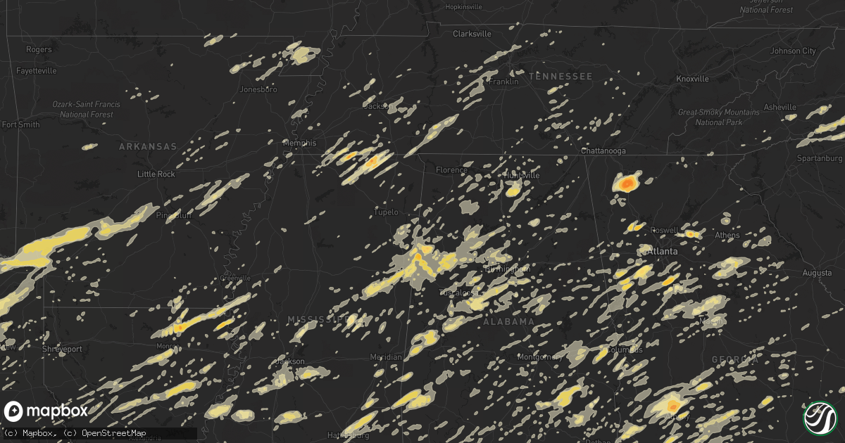
Hail Map in Mississippi on April 4, 2011
Get this storm
April 4 map
$229
one time, instant access
Download today. No call, no setup
Keep the $229
Bought the map and want the full workflow? Apply the entire $229 to a subscription within 7 days. None of it is wasted.
Every map, not just this one
This buys you this map. Subscription and you get every map we run, in the markets you choose from a few cities to whole states to nationwide. Plus real-time alerts the moment a storm fires.
Contact data
Name, contact info, occupancy, even credit band for addresses in the footprint. You go from where it hit to who to call.
Become the source they trust
Unlimited branding weather history reports on demand. You already have the documented answer ready for the property owner, and you are the one who showed up with it.
Property data and RoofTrace estimates
Pull up any address you have got, its value and the exact code rules for that jurisdiction, straight from One Click Code. Then RoofTrace estimates the squares, pitch, and roof value, priced the way you price.
Storm reports in Mississippi
Mississippi
| Date | Description |
|---|---|
| 04/04/20116:55 PM CDT | Trees were downed near monroe rd and i-59 |
| 04/04/20116:55 PM CDT | A power pole was downed and the eaves of an office building were damaged along us highway 98. |
| 04/04/20116:55 PM CDT | A large tree limb fell through the roof of a home along ray boone rd |
| 04/04/20116:49 PM CDT | Several trees down along hwy-49...were blocking highway but have now been cleared of to side. |
| 04/04/20116:49 PM CDT | Trees down |
| 04/04/20116:45 PM CDT | Trees down across eshee road |
| 04/04/20116:45 PM CDT | Large tree down across highway 49...blocking both southbound lanes |
| 04/04/20116:45 PM CDT | Multiple large trees reported down around sumrall |
| 04/04/20116:44 PM CDT | Several trees down across the southern part of the county |
| 04/04/20116:40 PM CDT | The roof was blown off of a shed along oloh rd in the oloh community |
| 04/04/20116:35 PM CDT | Trees down with roof off of one shed about 2 miles east of tylertown on hwy 48. Time estimated/corrected based on radar. |
| 04/04/20116:30 PM CDT | Trees down on a car and house in newton. Trees down across several strees and roads. |
| 04/04/20116:25 PM CDT | Numerous tree down across the southern part of the county |
| 04/04/20116:25 PM CDT | Tree down on a mobile home on river road. Exact location estimated |
| 04/04/20116:25 PM CDT | Two trees were downed in mize |
| 04/04/20116:23 PM CDT | Trees down across hwy 489 |
| 04/04/20116:23 PM CDT | Trees down across hwy 489 |
| 04/04/20116:21 PM CDT | Five trees were blown down around forest on highways 35 and 21. |
| 04/04/20116:20 PM CDT | Trees and power lines downed |
| 04/04/20116:12 PM CDT | Emergency manager reports trees down. |
| 04/04/20116:05 PM CDT | Numerous trees down across the county...damage near topeka included 2 mobile homes with trees on them...2 barns destroyed...2 houses with roof damage...another house wi |
| 04/04/20115:55 PM CDT | Lots of trees down in puckett and cato areas |
| 04/04/20115:51 PM CDT | Numerous trees down |
| 04/04/20115:50 PM CDT | Damage to ruth volunteer fire dept building. Can not get one truck out |
| 04/04/20115:50 PM CDT | Several trees down in area |
| 04/04/20115:50 PM CDT | Update...nws storm survey team determines an ef-1 tornado caused damage near ruth. Numerous trees down blocking roads and some trees down on mobile homes |
| 04/04/20115:48 PM CDT | Multiple houses damaged in the city of braxton. Trees down all across the city...with a few trees down onto houses. |
| 04/04/20115:40 PM CDT | Numerous trees down in the moaks creek area |
| 04/04/20115:38 PM CDT | Update...nws storm survey determined an ef1 tornado went through the city of braxton. Simpson county sherriff office reports numerous trees and power lines down with so |
| 04/04/20115:35 PM CDT | Tree was downed in the sunchase subdivision |
| 04/04/20115:30 PM CDT | Couple trees down near intersection of hwy 469 and williams road. |
| 04/04/20115:30 PM CDT | Nws storm survey team determined straight line winds caused a roof to be blown off a house...and down several trees near old pearl in far northwestern simpson county. |
| 04/04/20115:30 PM CDT | Roof blown off house in old pearl. |
| 04/04/20115:25 PM CDT | Some trees were blown down around louisville and just northwest of town on highway 15. |
| 04/04/20115:25 PM CDT | A tree fell on a house in the beechwood hills area of pearl |
| 04/04/20115:25 PM CDT | A large tree was downed across shady ln near richland. |
| 04/04/20115:25 PM CDT | Tree down across ruby road...and vehicle ran into it |
| 04/04/20115:25 PM CDT | Tree down across road 602 sw of arlington community |
| 04/04/20115:25 PM CDT | Tree downed along payne dr |
| 04/04/20115:25 PM CDT | Reported sw of arlington community |
| 04/04/20115:20 PM CDT | Several trees down |
| 04/04/20115:17 PM CDT | Several trees down |
| 04/04/20115:15 PM CDT | Several reports of hail up to size of quarters in the area near columbus |
| 04/04/20115:13 PM CDT | Numerous trees down...one on a house |
| 04/04/20115:10 PM CDT | Power lines were downed near i-55 and fortification st |
| 04/04/20115:10 PM CDT | A tree fell on a home near the intersection of hartfield st and oxford ave in the fondren district |
| 04/04/20115:10 PM CDT | Tree downed along robinhood rd between state st and manhattan rd |
| 04/04/20115:10 PM CDT | Trees were downed along old canton rd in ridgeland |
| 04/04/20115:08 PM CDT | Couple of trees down across highway 35 |
| 04/04/20115:05 PM CDT | Six trees were blown down in the southeast portion of the county along with quarter sized hail. |
| 04/04/20115:05 PM CDT | A tree was downed across school st near us highway 51. |
| 04/04/20115:00 PM CDT | Numerous trees down across roads across the county. One tree fell on a car |
| 04/04/20114:52 PM CDT | Several trees down along harriston rd just southwest of red lick..blocking road. |
| 04/04/20114:50 PM CDT | A large tree was downed along lakeview rd |
| 04/04/20114:50 PM CDT | Power lines were downed at northside elementary school |
| 04/04/20114:50 PM CDT | Numerous trees down all over western hinds county...including towns of edwards...bolton...and utica. |
| 04/04/20114:45 PM CDT | Trees down at intersection of highways 18 and 27 |
| 04/04/20114:45 PM CDT | Madison county sheriff dept reports numerous trees down across madison county |
| 04/04/20114:42 PM CDT | Ef-1 rated tornado with 95 mph winds...3.5 mile path length from 1.5 nnw utica to 4 ne utica and 0.25 mile path width...numerous pine trees snapped/uprooted and a numbe |
| 04/04/20114:41 PM CDT | Several trees down along stamply road north of town towards highway 61. |
| 04/04/20114:41 PM CDT | Quarter sized hail reported west of columbus |
| 04/04/20114:35 PM CDT | A small tree fell on a house along mullins rd. |
| 04/04/20114:32 PM CDT | A few trees were blown down off hwy 18. |
| 04/04/20114:32 PM CDT | Quarter sized hail reported west of columbus |
| 04/04/20114:25 PM CDT | Multiple trees downed around port gibson...three of which were blocking roads. |
| 04/04/20114:24 PM CDT | A local report indicates 70 MPH wind near 9 S VICKSBURG |
| 04/04/20114:20 PM CDT | Multiple trees were snapped or uprooted along i-20 near mile marker 7 |
| 04/04/20114:17 PM CDT | Power lines down on dunbarton rd and tree down on north palestine rd |
| 04/04/20114:15 PM CDT | Multiple trees downed...some blocking roads...near grand gulf |
| 04/04/20114:15 PM CDT | Trees down in the roseland forest area...minor damage to one residence |
| 04/04/20114:15 PM CDT | Nws storm survey determined an ef-1 tornado occurred in northern simpson county. Details to follow. |
| 04/04/20114:15 PM CDT | Roof damage to structures on fletchers chapel and myrleville roads |
| 04/04/20114:15 PM CDT | Roof damage to structures of fletchers and myrleville road |
| 04/04/20114:10 PM CDT | Trees down across the county. 3 power poles were snapped just east of vicksburg and a tree fell on a house just north of vicksburg |
| 04/04/20113:54 PM CDT | Tree uprooted with power lines down at wisteria st and laurel st...a school bus also trapped by power lines down awaiting assistance. |
| 04/04/20113:32 PM CDT | A few trees were blown down off hwy 18. |
| 04/04/20113:30 PM CDT | Several trees down along beasley-bayou road west of isola |
| 04/04/20112:58 PM CDT | Quarter sized hail reported |
| 04/04/20112:12 PM CDT | Tree down blocking hwy 25 just south of the town of belmont. |
| 04/04/20112:10 PM CDT | Trees and large branches town at the itawamba community college. Trees also down at other places in town...possible powerlines down. |
| 04/04/20112:05 PM CDT | Trees and powerlines down at various points in the town of tupelo...some trees landed on houses. |
| 04/04/20111:45 PM CDT | Tornado reported by a state trooper on the ground ms hwy 25 north near the tenn/tomm waterway. |
| 04/04/20111:45 PM CDT | Ms hwy 25 north near the tenn/tom waterway powerlines and trees down. |
| 04/04/20111:42 PM CDT | 18 wheeler turned over between guntown and tupelo. Trees reported down as well. |
| 04/04/20111:40 PM CDT | Small trailer was rolled over behind a truck on hwy 45 due to a strong wind gust. |
| 04/04/20111:35 PM CDT | Trees and powerlines down on carrollton road |
| 04/04/20111:25 PM CDT | Power lines and trees down along county road 1490...trees blocking county road 1390...and trees down along county road 3490. Relayed from prentiss county 911 by a ham r |
| 04/04/20111:15 PM CDT | Trees and powerlines down just west of new albany at the intersection of county road 86 and hwy 30. Winds are estimated at 60-70 mph. |
| 04/04/20111:00 PM CDT | Power lines down near wkrz tower on county road 611. Scattered trees down also reported in this part of the county. |
| 04/04/201112:51 PM CDT | Quarter size hail with a lot of nickel and dime hail. Tree limbs down near hwy 334 south of oxford |
| 04/04/201112:40 PM CDT | Several trees down across the county. |
| 04/04/201112:35 PM CDT | Shingles were blown off a home and several large limbs were downed. |
| 04/04/201112:32 PM CDT | Tree down on a car |
| 04/04/201112:30 PM CDT | A local report indicates 1.75 inch wind near MICHIGAN CITY |
| 04/04/201112:30 PM CDT | Several trees down across roads |
| 04/04/201112:25 PM CDT | Steeple blown off a church on bishop road |
| 04/04/201112:20 PM CDT | Reported along us highway 82 on the east side of greenville |
| 04/04/201112:15 PM CDT | Damage reported in the winterville community. Additional details to follow. |
| 04/04/201112:05 PM CDT | Trees down and lawn furniture thrown. 1 mile north of intersection of hwy 305 and hwy 4. |
| 04/04/201112:00 PM CDT | Multiple trees down in senatobia. |
| 04/04/201111:45 AM CDT | Part of roof torn off a house due to straight line winds...other houses had shingles torn off in the town of horn lake. |
| 04/04/201111:45 AM CDT | Also...wall cloud with some rotation near hwy 51 ne of hernando. |
| 04/04/201111:43 AM CDT | Powerlines down and trees uprooted in the town of robinsonville...winds estimated by caller at 70 mph. Near the intersection of hwy 61 and casino road. |
| 04/04/201111:36 AM CDT | Up to 40 power lines down or snapped along hwy 61 across the county. Lots of trees down and roofs damaged. The back wall of the north tunica fire department building wa |
| 04/04/201111:35 AM CDT | Farm building destroyed. Several trailers blown off the foundations. |
| 04/04/201110:50 AM CDT | Strong winds felt in town of tiplersville. |
| 04/04/201110:50 AM CDT | Hail fell in town of tiplersville. |
| 04/03/201110:05 PM CDT | Damage to 2 commercial buildings in fountainbleau. Additional damage to a few homes and several trees down. |
| 04/03/20118:45 PM CDT | Roofing peeled off of a couple metal commercial buildings in fountainbleau area.window blown out of two house. Large section of two fences blown down. Several medium tr |
| 04/03/20118:40 PM CDT | Damage to 2 commercial buildings in fountainbleau. Additional damage to a few homes and several trees down. Time corrected. |
| 04/03/20118:35 PM CDT | Trees down with roof off of one shed about 2 miles east of tylertown on hwy 48. Time estimated/corrected based on radar. |
| 04/03/20118:30 PM CDT | George county sheriff reported trees down along deer lane in plum bluff estates. Also numerous power outages in the area. |
| 04/03/20118:25 PM CDT | Roof off of businesses in northwood hills shopping center 12100 hwy 49. Trees down near orange grove rd. |
| 04/03/20118:08 PM CDT | Tree fell on power line on south st. Near clemont harbor. |
| 04/03/20117:58 PM CDT | A metal porch awning was destroyed in jonathan. |
| 04/03/20117:58 PM CDT | Near the town of old avera...ema reports a large stand of pine trees were broken completely in half. Ema adds that damage was more than a 100 yards wide...and that the |
| 04/03/20117:54 PM CDT | Tree down on rocky hill dedeaux rd. Just east of hwy. 603. |
| 04/03/20117:54 PM CDT | A tree down on inda road. |
| 04/03/20117:53 PM CDT | Large limbs downed along interstate 59 near mile marker 33. |
| 04/03/20117:52 PM CDT | Two trees down...one fell on truck at residence...the other across crazy horse drive west of highway 603. |
| 04/03/20117:49 PM CDT | At 830pm cdt...the county ema recieved information from local law enforcement of tornado damage including tree and powerline damage. Several car accidents may also be r |
| 04/03/20117:49 PM CDT | Local ema reports probable straight-line wind damage in avera. Path length estimated to be a couple hundred yards wide and a couple miles long. Damage time estimated fr |
| 04/03/20117:43 PM CDT | Multiple trees snapped a few soft woods and one hard wood. Two hardwoods uprooted. 40 percent of metal roof off house with a few roof beams broken off. Beams and metal |
| 04/03/20117:43 PM CDT | Moderate damage to a roof on connie hariel rd...roofing was blown about 50 to 100 yards downstream...large tree about 4 to 5 feet thick uprooted...and multpile trees sn |
| 04/03/20117:40 PM CDT | Trees down on mckenzie road. |
| 04/03/20117:40 PM CDT | Trees down on bucks creek road. |
| 04/03/20117:40 PM CDT | Trees down on hwy 15 just north of richton. |
| 04/03/20117:35 PM CDT | Roof torn off home on connie hairiel road. |
| 04/03/20117:23 PM CDT | Trees down with roof off of one shed about 2 miles east of tylertown on hwy 48. |
| 04/03/20117:23 PM CDT | Large limbs downed along interstate 59 near mile marker 33. Time estimated/corrected based on radar. |
| 04/03/20117:20 PM CDT | Numerous reports of trees over powerlines across central and southern portions of county. |
| 04/03/20117:15 PM CDT | Trees down on powerlines in southeast lauderdale county |
| 04/03/20117:08 PM CDT | Roof blown off a house |
| 04/03/20117:07 PM CDT | A tree fell on a mobile home severely damaging the home. |
| 04/03/20117:07 PM CDT | Damage to a mobile home |
| 04/03/20117:05 PM CDT | Power outages were reported all across the county from wind damage. Cities affected include rural portions of quitman...stonewall and enterprise. |
| 04/03/20117:05 PM CDT | Numerous trees down across the county. Two cars were blown off the road 2 miles north of petal |
| 04/03/20117:05 PM CDT | Trees down in the city. Power was out for a short time. |
| 04/03/20117:05 PM CDT | Significant damage to several structures in the hwy 590 area just west of ellisville |
| 04/03/20117:00 PM CDT | Tree fell on a house damaging the house. |
| 04/03/20117:00 PM CDT | Large tree limbs down across cr 16 |
| 04/03/20117:00 PM CDT | Wayne county sheriff reported numerous trees down between 7 pm and 810 pm. Widespread trees down across the county. |
| 04/03/20117:00 PM CDT | 1 house destroyed and roof off another. Exact location estimated |
All States Impacted by Hail Map on April 4, 2011
Cities Impacted by Hail Map on April 4, 2011
- Longview, TX
- Denmark, TN
- Medon, TN
- Crossville, TN
- Noble, LA
- Converse, LA
- Selmer, TN
- Boaz, AL
- Horton, AL
- Altoona, AL
- Jewell, GA
- Bloomington, IN
- Midland City, AL
- Ozark, AL
- Quitman, MS
- Meridian, MS
- Norman, IN
- Louisville, MS
- Weir, MS
- McCool, MS
- Clarendon, AR
- Casscoe, AR
- Almyra, AR
- Stuttgart, AR
- Crocketts Bluff, AR
- Delta, AL
- Woodville, TX
- Campti, LA
- Marietta, GA
- Eminence, MO
- Ethelsville, AL
- Ozan, AR
- Antoine, AR
- Okolona, AR
- Hooks, TX
- Blevins, AR
- Nashville, AR
- Alleene, AR
- Murfreesboro, AR
- De Kalb, TX
- Prescott, AR
- Delight, AR
- Ogden, AR
- Foreman, AR
- Saratoga, AR
- Texarkana, TX
- McCaskill, AR
- Ashdown, AR
- New Boston, TX
- Lockesburg, AR
- Avery, TX
- Columbus, AR
- Mineral Springs, AR
- Wilton, AR
- Evergreen, AL
- Fletcher, NC
- Buford, GA
- Hoschton, GA
- Flowery Branch, GA
- Auburn, GA
- Braselton, GA
- Mayo, FL
- Horseshoe Beach, FL
- Live Oak, FL
- Branford, FL
- Perry, FL
- Steinhatchee, FL
- Salem, FL
- Day, FL
- Old Town, FL
- Luverne, AL
- Goshen, AL
- Pine Bluff, AR
- Sherrill, AR
- Nashville, IN
- Ashland, AL
- Seneca, SC
- Ponce De Leon, FL
- Shreveport, LA
- Bradley, AR
- Taylor, AR
- Lafe, AR
- Rector, AR
- Marmaduke, AR
- Milam, TX
- Beallsville, OH
- Powhatan Point, OH
- Alledonia, OH
- Jacobsburg, OH
- Port Richey, FL
- New Port Richey, FL
- Hudson, FL
- Spring Hill, FL
- Lake Toxaway, NC
- Ponchatoula, LA
- Kane, PA
- Lewis Run, PA
- Warren, PA
- Tiona, PA
- Clarendon, PA
- Melville, LA
- Plaucheville, LA
- Palmetto, LA
- Milledgeville, TN
- Sardis, TN
- Bluffton, SC
- Lexington, GA
- Stephens, GA
- Bainbridge, GA
- Pontotoc, MS
- Centreville, AL
- Duncanville, AL
- Brent, AL
- West Blocton, AL
- Boligee, AL
- Livingston, AL
- Olivehill, TN
- Baileyton, AL
- Cullman, AL
- Huntsville, AL
- Union Grove, AL
- Somerville, AL
- Laceys Spring, AL
- Vinemont, AL
- New Hope, AL
- Eva, AL
- Canton, TX
- Leesburg, TX
- Mineola, TX
- Hughes Springs, TX
- Pittsburg, TX
- Quitman, TX
- Daingerfield, TX
- Hawkins, TX
- Naples, TX
- Como, TX
- Big Sandy, TX
- Gilmer, TX
- Omaha, TX
- Winnsboro, TX
- Atlanta, GA
- Shiloh, GA
- Hamilton, GA
- Cataula, GA
- Warm Springs, GA
- Jacksons Gap, AL
- Dadeville, AL
- Marion Junction, AL
- Uniontown, AL
- Wilsonville, AL
- Adger, AL
- Bessemer, AL
- Vance, AL
- Pelham, AL
- Knoxville, AL
- Alabaster, AL
- Brierfield, AL
- Fosters, AL
- Sterrett, AL
- Tuscaloosa, AL
- Birmingham, AL
- Harpersville, AL
- Moundville, AL
- Akron, AL
- Helena, AL
- Montevallo, AL
- Cottondale, AL
- Chelsea, AL
- Vincent, AL
- Columbiana, AL
- Brookwood, AL
- McCalla, AL
- Woodstock, AL
- Williams, IN
- Guntersville, AL
- Midland, GA
- Collierville, TN
- Williston, TN
- Somerville, TN
- Rossville, TN
- Moscow, TN
- Barlow, KY
- Greensboro, GA
- Madison, GA
- Dayton, OH
- Longs, SC
- Conway, SC
- Loris, SC
- Adamsville, AL
- Monroe, LA
- Ethel, MS
- Kosciusko, MS
- Trinity, AL
- Moulton, AL
- Hillsboro, AL
- Andalusia, AL
- Red Level, AL
- Gordo, AL
- Steens, MS
- Sulligent, AL
- Bankston, AL
- Oakman, AL
- Parrish, AL
- Crane Hill, AL
- Caledonia, MS
- Arley, AL
- Beaverton, AL
- Double Springs, AL
- Reform, AL
- Berry, AL
- Millport, AL
- Aberdeen, MS
- Hanceville, AL
- Nauvoo, AL
- Bremen, AL
- Jasper, AL
- Sturgis, MS
- Carbon Hill, AL
- Brooksville, MS
- Starkville, MS
- Houston, AL
- Kennedy, AL
- Greenwood Springs, MS
- Gattman, MS
- Carrollton, AL
- West Point, MS
- Detroit, AL
- Cordova, AL
- Hamilton, MS
- Fayette, AL
- Northport, AL
- Vernon, AL
- Columbus, MS
- Townley, AL
- Crawford, MS
- Robeline, LA
- Marthaville, LA
- Brickeys, AR
- Marianna, AR
- Tunica, MS
- Isola, MS
- Inverness, MS
- Leland, MS
- Greenville, MS
- Colfax, LA
- Dry Prong, LA
- Magnolia, AR
- McNeil, AR
- Petersburg, TN
- Bremen, GA
- Temple, GA
- Carrollton, GA
- Clay, KY
- Winfield, AL
- Eldridge, AL
- Shubuta, MS
- Marksville, LA
- Hessmer, LA
- Newnan, GA
- Palmetto, GA
- Fairburn, GA
- Sharpsburg, GA
- Chidester, AR
- Homerville, GA
- Thomaston, AL
- Bogata, TX
- De Kalb, MS
- Hawkinsville, GA
- Eastman, GA
- Coal Center, PA
- Daisytown, PA
- Clayton, AL
- Vale, NC
- Lincolnton, NC
- Florence, MS
- Bastrop, LA
- Hilliard, FL
- Humboldt, TN
- Trenton, TN
- De Berry, TX
- Bethany, LA
- Hackleburg, AL
- Hamilton, AL
- Union Springs, AL
- Troy, AL
- Grady, AL
- Wind Ridge, PA
- Cameron, WV
- Glen Easton, WV
- Hornbeck, LA
- Tutwiler, MS
- Thornton, TX
- Groesbeck, TX
- Fairfield, TX
- Teague, TX
- Donie, TX
- Franklin, GA
- Douglasville, GA
- Whitesburg, GA
- Roopville, GA
- San Augustine, TX
- Palmer, TN
- Milton, FL
- Holt, FL
- Millington, TN
- Childersburg, AL
- Alpine, AL
- Louisville, GA
- Stapleton, GA
- Ariton, AL
- Long Branch, TX
- Mount Enterprise, TX
- Tifton, GA
- Montville, OH
- Chardon, OH
- Faunsdale, AL
- Linden, AL
- Saint Albans, WV
- Tornado, WV
- Camilla, GA
- Ellisville, MS
- Ovett, MS
- Petal, MS
- Hattiesburg, MS
- Richton, MS
- Waynesboro, MS
- Moselle, MS
- Laurel, MS
- Hartford, AL
- Slocomb, AL
- Albany, GA
- Sylvester, GA
- Crofton, KY
- White Plains, KY
- Gadsden, AL
- Lawrenceville, GA
- Kennett, MO
- Mooresboro, NC
- Shelby, NC
- Gaffney, SC
- Lewisville, AR
- Hull, GA
- Nicholson, GA
- Commerce, GA
- Merom, IN
- Hutsonville, IL
- Sullivan, IN
- Fairbanks, IN
- Mayersville, MS
- Lake Providence, LA
- Lawndale, NC
- Cherryville, NC
- Acworth, GA
- Dallas, GA
- Graysville, AL
- Shelbyville, IN
- Fargo, GA
- Hogansville, GA
- Ash, NC
- Bolton, NC
- Mount Olive, AL
- Clarkson, KY
- Cub Run, KY
- Munfordville, KY
- Panama City, FL
- Lindale, TX
- Tyler, TX
- Winona, TX
- Morgantown, KY
- Belton, KY
- Dunmor, KY
- Lewisburg, KY
- Guthrie, KY
- Elkton, KY
- Branchland, WV
- Weogufka, AL
- Sylacauga, AL
- Hendersonville, TN
- Germantown, OH
- La Grange, TN
- Lamar, MS
- Michigan City, MS
- Byhalia, MS
- Red Banks, MS
- Holly Springs, MS
- Grand Junction, TN
- Blakely, GA
- Horse Cave, KY
- Cave City, KY
- Bowling Green, KY
- Cory, IN
- Clay City, IN
- Pimento, IN
- Lewis, IN
- Huntingdon, TN
- Hollow Rock, TN
- Bruceton, TN
- Griffin, GA
- Williamson, GA
- Opp, AL
- Kite, GA
- Adrian, GA
- Dover, AR
- Harrison, TN
- Soddy Daisy, TN
- Greer, SC
- Landrum, SC
- Taylors, SC
- Philadelphia, MS
- Gray, GA
- Haddock, GA
- Juliette, GA
- Hillsboro, GA
- Forsyth, GA
- Macon, GA
- Mocksville, NC
- Newellton, LA
- Tallulah, LA
- Leeds, AL
- Coal City, IN
- Freedom, IN
- Spencer, IN
- Gosport, IN
- Ellettsville, IN
- Worthington, IN
- Wadley, AL
- Natchez, MS
- Lecanto, FL
- Hernando, FL
- Inverness, FL
- Homosassa, FL
- Oneonta, AL
- Tiplersville, MS
- Transylvania, LA
- Cary, MS
- Sondheimer, LA
- Rolling Fork, MS
- Diana, TX
- Avinger, TX
- Ore City, TX
- Jefferson, TX
- Valhermoso Springs, AL
- Butler, AL
- Dacula, GA
- Austin, TX
- Leander, TX
- Cedar Park, TX
- Uvalda, GA
- Lyons, GA
- Thomasville, GA
- Hampton, GA
- Mcdonough, GA
- Locust Grove, GA
- Hazlehurst, GA
- West Green, GA
- Denton, GA
- Monticello, FL
- Dunlap, TN
- Natchitoches, LA
- Fayette, MS
- Ferriday, LA
- Fort Benning, GA
- Wing, AL
- Brantley, AL
- Rutledge, AL
- Nebo, NC
- Union Mills, NC
- Morganton, NC
- Valley Mills, TX
- Crawford, TX
- Vienna, GA
- Cordele, GA
- Miamisburg, OH
- Blountsville, AL
- Armuchee, GA
- Rome, GA
- Calhoun, GA
- McCrory, AR
- Augusta, AR
- Yazoo City, MS
- Yantis, TX
- Sulphur Springs, TX
- Opelika, AL
- Salem, AL
- Hatchechubbee, AL
- Seale, AL
- Hurtsboro, AL
- Phenix City, AL
- Honoraville, AL
- Terre Haute, IN
- Farmersburg, IN
- Bells, TN
- Jackson, TN
- Winnsboro, LA
- Fort Necessity, LA
- South Park, PA
- Clairton, PA
- Finleyville, PA
- Waverly Hall, GA
- Greenville, FL
- Makanda, IL
- Alto Pass, IL
- Carbondale, IL
- Cobden, IL
- Hayneville, AL
- Tyler, AL
- East Prairie, MO
- Matthews, MO
- Ellenboro, NC
- Rockdale, TX
- Thorndale, TX
- Town Creek, AL
- Sterlington, LA
- Farmerville, LA
- Waycross, GA
- Leesburg, GA
- Smithville, GA
- Bronwood, GA
- Dawson, GA
- Suwanee, GA
- Greensburg, IN
- Crossett, AR
- Hamburg, AR
- Gerton, NC
- Fairview, NC
- Hendersonville, NC
- Black Mountain, NC
- Sumner, GA
- Newport, AR
- Marietta, TX
- Palestine, TX
- Arp, TX
- Gladewater, TX
- Fruitvale, TX
- Grand Saline, TX
- Linden, TX
- Edgewood, TX
- Douglassville, TX
- Lone Star, TX
- Flint, TX
- Brownsboro, TX
- Alba, TX
- Athens, TX
- Whitehouse, TX
- Ben Wheeler, TX
- Chandler, TX
- Frankston, TX
- Wills Point, TX
- Larue, TX
- Tennessee Colony, TX
- Emory, TX
- Bullard, TX
- Van, TX
- Montalba, TX
- Scroggins, TX
- Carthage, MS
- Lumpkin, GA
- Cusseta, GA
- Richland, GA
- Talco, TX
- Mount Pleasant, TX
- Mount Vernon, TX
- Calera, AL
- Poulan, GA
- Indianapolis, IN
- Greenwood, IN
- Fairland, IN
- Needham, IN
- Boggstown, IN
- Georgetown, GA
- Athens, AL
- Elkmont, AL
- Middleton, TN
- Graceville, FL
- Waco, GA
- Deridder, LA
- New Castle, IN
- Whiteland, IN
- Eatonton, GA
- Buckhead, GA
- La Center, KY
- Kevil, KY
- Chatsworth, GA
- Dalton, GA
- Sugar Valley, GA
- Resaca, GA
- Ashland, MS
- Collinston, LA
- Mer Rouge, LA
- Crystal Springs, MS
- Hermanville, MS
- Utica, MS
- Hazlehurst, MS
- Scipio, IN
- Golconda, IL
- Fort Mitchell, AL
- Hickory Flat, MS
- Potts Camp, MS
- Granger, TX
- Taylor, TX
- Georgetown, TX
- Aquilla, TX
- China Spring, TX
- Whitney, TX
- Clifton, TX
- Ventress, LA
- Aliceville, AL
- Marion, KY
- Addison, AL
- Russellville, AL
- Danville, AL
- Haleyville, AL
- Belle Rose, LA
- Madison, FL
- Waldo, AR
- Forest, MS
- Raleigh, MS
- Silsbee, TX
- Marbury, AL
- Equality, AL
- Rockford, AL
- Titus, AL
- Deatsville, AL
- Kilgore, TX
- Sparkman, AR
- Clarksville, TX
- Annona, TX
- Eustace, TX
- Overton, TX
- Murchison, TX
- Haworth, OK
- White Oak, TX
- Maud, TX
- Dike, TX
- Prattsville, AR
- Jacksonville, TX
- Jewett, TX
- Saltillo, TX
- Queen City, TX
- Kaufman, TX
- Mexia, TX
- Horatio, AR
- Donaldson, AR
- Leola, AR
- Gurdon, AR
- Atlanta, TX
- Texarkana, AR
- Arkadelphia, AR
- Grapevine, AR
- Fulton, AR
- Pickton, TX
- Nash, TX
- Cookville, TX
- Sheridan, AR
- Hallsville, TX
- Carthage, AR
- Tallahassee, FL
- Phil Campbell, AL
- Gatewood, MO
- Woodbury, TN
- Many, LA
- Louisville, AL
- Letohatchee, AL
- Lowndesboro, AL
- Hope Hull, AL
- Coker, AL
- Buhl, AL
- Linesville, PA
- Vaughan, MS
- Lebanon, TN
- Goodlettsville, TN
- Fredonia, KY
- Tichnor, AR
- Jackson, GA
- Alberta, AL
- Catherine, AL
- Youngstown, FL
- Woodland, AL
- Muscadine, AL
- Tallapoosa, GA
- Buchanan, GA
- Madison, AL
- Nashville, TN
- Madison, TN
- Duck River, TN
- Centerville, TN
- Midway, FL
- Quincy, FL
- Havana, FL
- Dry Creek, LA
- Huron, TN
- Pinson, TN
- Henderson, TN
- Beech Bluff, TN
- Luray, TN
- Lexington, TN
- Ray City, GA
- Hilton Head Island, SC
- Pulaski, MS
- Tatum, TX
- Henderson, TX
- Dry Branch, GA
- Greensburg, LA
- Savannah, TN
- Lynn, AL
- Cartersville, GA
- Hemphill, TX
- Lake Park, GA
- Valdosta, GA
- Forest City, NC
- Bostic, NC
- Rutherfordton, NC
- Spindale, NC
- Belle Vernon, PA
- Waynesburg, PA
- Scenery Hill, PA
- Prosperity, PA
- Richeyville, PA
- Fredericktown, PA
- Dunlevy, PA
- Monessen, PA
- Beallsville, PA
- Amity, PA
- Marianna, PA
- Charleroi, PA
- Williamsville, MO
- Ludowici, GA
- Ashland City, TN
- Steele, AL
- Wedowee, AL
- Lineville, AL
- Cragford, AL
- Toxey, AL
- Gilbertown, AL
- Millry, AL
- Frankville, AL
- Sweet Water, AL
- Thomasville, AL
- Silas, AL
- Campbell, AL
- Coffeeville, AL
- Bogue Chitto, MS
- Doerun, GA
- Hartsfield, GA
- Omega, GA
- Ocilla, GA
- Norman Park, GA
- Chula, GA
- Fitzgerald, GA
- Funston, GA
- Moultrie, GA
- Meigs, GA
- Ty Ty, GA
- Grand Ridge, FL
- Marianna, FL
- Manchester, TN
- Tullahoma, TN
- Dora, AL
- Lake City, FL
- Ailey, GA
- Mount Vernon, GA
- Tarrytown, GA
- Vidalia, GA
- Eddyville, KY
- Shellman, GA
- Beebe, AR
- Brookhaven, MS
- Bronson, TX
- Bonifay, FL
- West Monroe, LA
- Estill Springs, TN
- Canonsburg, PA
- Washington, PA
- McEwen, TN
- Dickson, TN
- Hollandale, MS
- Rienzi, MS
- Corinth, MS
- Dixie, GA
- Earle, AR
- Sarepta, LA
- Oak Grove, LA
- Camden, MS
- Mendenhall, MS
- Pelahatchie, MS
- Brandon, MS
- Braxton, MS
- Rebecca, GA
- Sycamore, GA
- Odum, GA
- Kuttawa, KY
- Minter, AL
- Saulsbury, TN
- Walnut, MS
- Wiggins, MS
- Brooklyn, MS
- Lake Village, AR
- Lucedale, MS
- McLain, MS
- Peachtree City, GA
- Roanoke, AL
- Union City, GA
- Lanett, AL
- Lagrange, GA
- Cusseta, AL
- Lafayette, AL
- Tyrone, GA
- Five Points, AL
- Senoia, GA
- Grantville, GA
- Fayetteville, GA
- Moreland, GA
- Sandersville, GA
- Beatrice, AL
- Pine Apple, AL
- New Market, AL
- Graysville, TN
- Dayton, TN
- Pikeville, TN
- Sale Creek, TN
- Lake City, AR
- Buena Vista, GA
- Eudora, AR
- Liberty, SC
- Easley, SC
- Brookland, AR
- Paragould, AR
- Jonesboro, AR
- Chester, IL
- Ellis Grove, IL
- Saint Mary, MO
- Cuba, AL
- York, AL
- Naylor, GA
- Terry, MS
- Springfield, TN
- Orlinda, TN
- Bedford, IN
- Wetumpka, AL
- Eclectic, AL
- Mantee, MS
- Mathiston, MS
- Maben, MS
- Eupora, MS
- Annapolis, IL
- Palestine, IL
- Shelburn, IN
- Robinson, IL
- West York, IL
- Quitman, GA
- Chunchula, AL
- Citronelle, AL
- Stockbridge, GA
- Jonesboro, GA
- Rex, GA
- Laurel Hill, FL
- Florala, AL
- Scurry, TX
- Vidalia, LA
- Pollock, LA
- Trout, LA
- Counce, TN
- Andrews, SC
- Waynesboro, TN
- Clifton, TN
- Hohenwald, TN
- North Augusta, SC
- Jasper, TX
- Prattville, AL
- Jesup, GA
- Carthage, IN
- Knightstown, IN
- Morristown, IN
- Greenfield, IN
- Arlington, IN
- Dozier, AL
- Angie, LA
- Goodwater, AL
- Ararat, VA
- Meadows Of Dan, VA
- Laurel Fork, VA
- Hillsville, VA
- Reynolds, GA
- Doniphan, MO
- Watertown, TN
- Heth, AR
- Widener, AR
- Bunkie, LA
- Baconton, GA
- Newton, GA
- Booneville, MS
- Loranger, LA
- Folsom, LA
- Arlington, AL
- Pine Hill, AL
- Dixons Mills, AL
- Magnolia, AL
- Manor, TX
- Tabor City, NC
- Glenville, NC
- Cashiers, NC
- Milano, TX
- Cameron, TX
- Buckholts, TX
- Davilla, TX
- Clarington, OH
- Bragg City, MO
- Mitchell, GA
- Warrenton, GA
- Boston, GA
- Kings Mountain, NC
- Wisner, LA
- Glenwood, GA
- Alexandria, LA
- Woodworth, LA
- Lecompte, LA
- Westville, FL
- Clio, AL
- Jena, LA
- Grayson, LA
- Columbia, LA
- Pensacola, FL
- Robertsdale, AL
- Princeton, KY
- Freeport, FL
- Union, MS
- Dongola, IL
- Cuthbert, GA
- Coleman, GA
- Coolidge, GA
- Ochlocknee, GA
- Smithville, MS
- Fountain, FL
- Defuniak Springs, FL
- Amory, MS
- Nakina, NC
- Delco, NC
- Whiteville, NC
- Sweeden, KY
- Bee Spring, KY
- Mammoth Cave, KY
- Saint Stephen, SC
- Bonneau, SC
- Pocahontas, TN
- Ripley, MS
- Falkner, MS
- Tignall, GA
- Washington, GA
- Rayle, GA
- Campobello, SC
- Clarksville, FL
- Lisman, AL
- Columbia, MS
- Sandy Hook, MS
- Warner Robins, GA
- Altheimer, AR
- Wabbaseka, AR
- Hurricane, WV
- Hamlin, WV
- Dunbar, WV
- Griffithsville, WV
- Sod, WV
- Nitro, WV
- Alum Creek, WV
- Omaha, GA
- Griffithville, AR
- Covington, GA
- McDavid, FL
- Tanner, AL
- Donalsonville, GA
- Gordon, AL
- Jakin, GA
- Colquitt, GA
- Comer, GA
- Colbert, GA
- Danielsville, GA
- Monroe City, IN
- Hillsboro, TN
- Bartow, GA
- Highland Home, AL
- McClellandtown, PA
- Cotton Valley, LA
- Pitkin, LA
- Leesville, LA
- Elmer, LA
- Fort Polk, LA
- Glenmora, LA
- Hineston, LA
- Powder Springs, GA
- Lithia Springs, GA
- Mableton, GA
- Austell, GA
- Clarkdale, GA
- Mansfield, GA
- Bonnieville, KY
- Rockville, IN
- Montezuma, IN
- Crestview, FL
- Eglin Afb, FL
- Canton, MS
- Pine Mountain, GA
- Denham Springs, LA
- Walker, LA
- Vina, AL
- Hodges, AL
- Fordsville, KY
- Hartford, KY
- Washington, AR
- Sparta, TN
- Waverly, AL
- Auburn, AL
- Newton, NC
- Mooresville, NC
- Maiden, NC
- Crouse, NC
- Troutman, NC
- Columbus, NC
- Tryon, NC
- Statesville, NC
- Claremont, NC
- Mill Spring, NC
- Sherrills Ford, NC
- Terrell, NC
- Catawba, NC
- Westmoreland, TN
- Hartsville, TN
- Lafayette, TN
- Bethpage, TN
- Saluda, SC
- Edgefield, SC
- Shuqualak, MS
- Auburn, KY
- Jasper, FL
- Belton, SC
- Honea Path, SC
- Winston, GA
- Villa Rica, GA
- Epps, LA
- Pioneer, LA
- Plainville, GA
- Newville, AL
- Eros, LA
- Forkland, AL
- Bellamy, AL
- Epes, AL
- Butler, GA
- Roberta, GA
- Pittsview, AL
- Courtland, MS
- Oakland, MS
- Enid, MS
- Pope, MS
- Dardanelle, AR
- Danville, AR
- Belleville, AR
- Woodleaf, NC
- East Dublin, GA
- Dublin, GA
- Blairsville, GA
- Mason, IL
- Oblong, IL
- Jasonville, IN
- West Union, IL
- Willow Hill, IL
- Newton, IL
- Hymera, IN
- Yale, IL
- Coalmont, IN
- Wheeler, IL
- Dieterich, IL
- Lawrenceburg, TN
- Paris, IL
- Climax, GA
- Chatham, LA
- Jonesboro, LA
- Emelle, AL
- Bascom, FL
- Centerpoint, IN
- Poland, IN
- Eufaula, AL
- Banks, AL
- Memphis, TN
- Thomson, GA
- Pitts, GA
- Rochelle, GA
- Ashburn, GA
- Arabi, GA
- Central, SC
- Union Church, MS
- Roxie, MS
- Meadville, MS
- McCall Creek, MS
- Vienna, IL
- Washington, IN
- Portland, AR
- Montrose, AR
- Marlin, TX
- Doddridge, AR
- Cadiz, KY
- Sparta, GA
- Cobbtown, GA
- Pelham, TN
- Altamont, TN
- Inglis, FL
- Cedar Key, FL
- Chiefland, FL
- Rockfield, KY
- Tylertown, MS
- Mount Hermon, LA
- Franklinton, LA
- Weston, GA
- Coushatta, LA
- Pelican, LA
- Clinton, IN
- Clinton, MS
- Bolton, MS
- Jackson, MS
- Thorsby, AL
- Jemison, AL
- Clanton, AL
- Kimberly, AL
- Mulga, AL
- Fultondale, AL
- Gardendale, AL
- Quinton, AL
- Sumiton, AL
- Warrior, AL
- Empire, AL
- Trafford, AL
- Morris, AL
- Brookside, AL
- Hayden, AL
- Irvington, AL
- West Point, GA
- Hahira, GA
- Morven, GA
- Rushville, IN
- Cowan, TN
- Decherd, TN
- Bivins, TX
- Vivian, LA
- Mountain View, AR
- Fox, AR
- Clinton, AR
- Shirley, AR
- Nashville, GA
- Newton, AL
- Waskom, TX
- Mooringsport, LA
- Montgomery, IN
- Loogootee, IN
- Cannelburg, IN
- Petersburg, IN
- Mangham, LA
- Broxton, GA
- Cairo, GA
- Seminole, AL
- Elberta, AL
- Moody, AL
- Pell City, AL
- Damascus, GA
- Noxapater, MS
- Morgantown, IN
- Anderson, SC
- Wrightsville, GA
- Rayville, LA
- Whites Creek, TN
- Spruce Pine, AL
- Attapulgus, GA
- Troy, SC
- McCormick, SC
- Mount Carmel, IL
- Bone Gap, IL
- Toomsboro, GA
- Olla, LA
- Enterprise, LA
- Harrisonburg, LA
- Jerusalem, OH
- Graham, AL
- Jenkinsburg, GA
- Flovilla, GA
- Jasper, TN
- Bethlehem, GA
- Winder, GA
- Brewton, AL
- Bethesda, OH
- Belmont, OH
- Hickory Ridge, AR
- Wynne, AR
- Oran, MO
- Nacogdoches, TX
- Cottondale, FL
- Alford, FL
- Hope, AR
- Enville, TN
- Jacks Creek, TN
- Nineveh, IN
- Franklin, IN
- Trafalgar, IN
- Columbus, GA
- Sequatchie, TN
- Bentleyville, PA
- Eighty Four, PA
- Batesville, MS
- Oxford, MS
- Water Valley, MS
- Hornsby, TN
- Altha, FL
- Baxley, GA
- Stevenson, AL
- Livingston, TN
- Beech Grove, AR
- Delaplaine, AR
- Columbia, AL
- Holden, LA
- Sawyerville, AL
- Shorterville, AL
- Abbeville, AL
- Ider, AL
- Henagar, AL
- Morganfield, KY
- Thebes, IL
- McRae Helena, GA
- Singer, LA
- Hernando, MS
- Coldwater, MS
- Mount Carmel, SC
- Sylvania, GA
- Girard, GA
- Woolwine, VA
- Willis, VA
- Floyd, VA
- Fancy Gap, VA
- Evergreen, LA
- Washington, LA
- Morrow, LA
- Brockwell, AR
- Finger, TN
- Bethel Springs, TN
- Marion, AL
- Adel, GA
- Covington, LA
- Union Point, GA
- White Plains, GA
- Rutledge, GA
- Shady Dale, GA
- Monticello, GA
- Newborn, GA
- Bradley, SC
- Monroe, GA
- Hutto, TX
- Pflugerville, TX
- Roundhill, KY
- Port Saint Joe, FL
- Saint George, GA
- Dunnellon, FL
- Crystal River, FL
- Ocala, FL
- Toney, AL
- Buckner, AR
- Heflin, AL
- Fruithurst, AL
- Glenwood, IN
- Bristol, FL
- Couch, MO
- Greenville, AL
- Brevard, NC
- Surrency, GA
- La Fayette, GA
- Ranger, GA
- Summerville, GA
- Greenville, KY
- Rochester, KY
- Greensboro, AL
- Pearl, MS
- Cadwell, GA
- Searcy, AR
- Fountaintown, IN
- New Palestine, IN
- Marion, LA
- Lowgap, NC
- Mount Airy, NC
- Humnoke, AR
- Ulm, AR
- Carlisle, AR
- Cotton Plant, AR
- Walnut Ridge, AR
- Portia, AR
- Hoxie, AR
- Millerville, AL
- Arab, AL
- Merryville, LA
- Montgomery, AL
- Gibson, GA
- Pearson, GA
- Willacoochee, GA
- Henderson, KY
- Courtland, AL
- Centreville, MS
- Houston, MS
- Prairie, MS
- Brundidge, AL
- Marion, NC
- Lake Lure, NC
- Randolph, AL
- Brooks, GA
- Luthersville, GA
- Whitwell, TN
- Duluth, GA
- Guin, AL
- Delhi, LA
- Pavo, GA
- Farina, IL
- Twin City, GA
- Soperton, GA
- Swainsboro, GA
- Tuskegee, AL
- Jones, LA
- Glen Allan, MS
- Chatham, MS
- Bonita, LA
- Williamsport, TN
- Bon Aqua, TN
- Fairview, TN
- Primm Springs, TN
- Lyles, TN
- Santa Fe, TN
- Franklin, TN
- Kingston Springs, TN
- Nunnelly, TN
- Okolona, MS
- Sebree, KY
- Calhoun, KY
- Tickfaw, LA
- Hammond, LA
- Chauncey, GA
- White Springs, FL
- Qulin, MO
- Ashley, IL
- Woodlawn, IL
- Mount Vernon, IL
- Mount Hope, AL
- Rainbow City, AL
- Des Arc, AR
- Piedmont, AL
- Charleston, MO
- Carlton, GA
- Lamont, FL
- Ravenden Springs, AR
- Myrtle, MO
- Ravenden, AR
- Mammoth Spring, AR
- Pocahontas, AR
- Hardy, AR
- Valley Park, MS
- Cantonment, FL
- Eutaw, AL
- Blue Mountain, MS
- Ramer, TN
- Enterprise, MS
- Dearing, GA
- Charlottesville, IN
- Wilkinson, IN
- Shirley, IN
- De Valls Bluff, AR
- Roe, AR
- Liberty, IN
- Normandy, TN
- Wartrace, TN
- Raeford, NC
- Readyville, TN
- Liberty, TN
- Smithville, TN
- Duncan, SC
- Wellford, SC
- Fort Deposit, AL
- Loganville, GA
- Forest Home, AL
- Kingston, GA
- Taylorsville, GA
- Attalla, AL
- Gallant, AL
- Smithland, KY
- Burna, KY
- Musella, GA
- Knoxville, GA
- Glennville, GA
- Freetown, IN
- Shadyside, OH
- Wheeling, WV
- Valley Grove, WV
- Claysville, PA
- Glen Dale, WV
- Benwood, WV
- Triadelphia, WV
- Mcmechen, WV
- West Alexander, PA
- Safford, AL
- Longville, LA
- Hughes, AR
- Rogersville, AL
- Killen, AL
- Rocky Face, GA
- Leighton, AL
- Monticello, MS
- Sontag, MS
- Silver Creek, MS
- Prentiss, MS
- Jayess, MS
- Brownsville, IN
- Dixon, KY
- Claxton, GA
- Collins, GA
- Greenway, AR
- Piggott, AR
- Holcomb, MO
- Campbell, MO
- Gretna, FL
- Deer Park, AL
- McIntosh, AL
- Preston, MS
- Dundee, KY
- Fort Valley, GA
- Wrens, GA
- Rockmart, GA
- Barney, GA
- Emerson, AR
- Lakeland, GA
- Crawfordville, FL
- Box Springs, GA
- Ellerslie, GA
- Upatoi, GA
- Smiths Station, AL
- Tibbie, AL
- Paragon, IN
- Martinsville, IN
- Medina, TN
- Pisgah Forest, NC
- Rosman, NC
- Kelly, LA
- Montgomery, LA
- Georgetown, LA
- Natchez, LA
- Tullos, LA
- Atlanta, LA
- Cloutierville, LA
- Winnfield, LA
- Sicily Island, LA
- Gilbert, LA
- Fort Stewart, GA
- Pleasant Hill, LA
- Bargersville, IN
- Rusk, TX
- Pineview, GA
- Odenville, AL
- Elba, AL
- Falls Of Rough, KY
- Six Mile, SC
- Greenville, SC
- Pickens, SC
- Brownsville, KY
- Oakland, KY
- Park City, KY
- Smiths Grove, KY
- Fairborn, OH
- Indianola, MS
- Goldonna, LA
- Thayer, MO
- Hurricane Mills, TN
- Wellborn, FL
- Selma, AL
- Grandin, MO
- Satartia, MS
- Keithville, LA
- Byram, MS
- Centertown, KY
- Central City, KY
- Hollytree, AL
- Pattison, MS
- Greenwood, FL
- Hickory Valley, TN
- Caneyville, KY
- Leitchfield, KY
- Valley, AL
- Abita Springs, LA
- Bush, LA
- Pearl River, LA
- Paducah, KY
- Watson, AR
- Dumas, AR
- Stephens, AR
- Williston, FL
- Leslie, AR
- Marshall, TX
- Lloyd, FL
- Pinetta, FL
- Bonne Terre, MO
- Cushing, TX
- Mountain Rest, SC
- Fayetteville, TN
- Taft, TN
- Kirbyville, TX
- Edgewood, IL
- Louisville, IL
- Waldron, IN
- Saint Paul, IN
- Ohatchee, AL
- Ashville, AL
- Midville, GA
- Millen, GA
- Saint Clairsville, OH
- De Witt, AR
- Avera, GA
- Sneads, FL
- Dennard, AR
- Midway, AL
- Lonoke, AR
- Ramer, AL
- Lapine, AL
- Talladega, AL
- Reagan, TN
- Decaturville, TN
- Scotts Hill, TN
- Darden, TN
- Lizella, GA
- Morton, MS
- Pike Road, AL
- Hardaway, AL
- Fortson, GA
- Tuskegee Institute, AL
- Notasulga, AL
- Shorter, AL
- Tallassee, AL
- Oberlin, LA
- Oakdale, LA
- Bluffton, GA
- Arlington, GA
- Metropolis, IL
- Monroeville, AL
- Peterman, AL
- Jonesville, LA
- Pansey, AL
- Chattahoochee, FL
- Sparks, GA
- Hazel Green, AL
- Burnsville, MS
- Michie, TN
- Section, AL
- Dutton, AL
- Port Gibson, MS
- Adairville, KY
- Dexter, GA
- Rentz, GA
- Parsons, TN
- Crawfordville, GA
- Alapaha, GA
- Lock Haven, PA
- Cammal, PA
- Calvert, TX
- Lutts, TN
- Collinwood, TN
- Meridianville, AL
- Monterey, LA
- Karnack, TX
- Monteagle, TN
- Sewanee, TN
- Panama City Beach, FL
- Emerson, GA
- Harvest, AL
- Woodland, GA
- Beckville, TX
- Baker, FL
- Gadsden, TN
- Watkinsville, GA
- Athens, GA
- Pisgah, AL
- Sylvania, AL
- Rainsville, AL
- Lorman, MS
- Taylorsville, NC
- Lafitte, LA
- Marrero, LA
- Quincy, IN
- Cloverdale, IN
- Tracy City, TN
- Coalmont, TN
- Quaker City, OH
- Summerfield, OH
- Barnesville, OH
- Woodsfield, OH
- Ullin, IL
- Ardmore, TN
- Grand Rivers, KY
- Tiline, KY
- Call, TX
- Vernon, FL
- Russellville, KY
- Pollok, TX
- Collinsville, AL
- Gloster, MS
- Crosby, MS
- Buckatunna, MS
- Mart, TX
- Gantt, AL
- Atoka, TN
- McAlpin, FL
- Saline, LA
- Holly Grove, AR
- Langston, AL
- Albertville, AL
- Groveoak, AL
- Abbeville, GA
- Rhine, GA
- Milan, GA
- Ranburne, AL
- Bowdon, GA
- Fulton, MS
- Statenville, GA
- Jennings, FL
- Du Pont, GA
- Stockton, GA
- Moody Afb, GA
- Brilliant, AL
- Fitzpatrick, AL
- Mathews, AL
- Wardell, MO
- Steele, MO
- Hornersville, MO
- Hayti, MO
- Portageville, MO
- Senath, MO
- Glenwood, AL
- Edison, GA
- Startex, SC
- Spartanburg, SC
- Moore, SC
- Needham, AL
- Lauderdale, MS
- Daleville, MS
- Broaddus, TX
- Ridgeland, MS
- Frazeysburg, OH
- Collinsville, MS
- Antioch, TN
- Brentwood, TN
- Shoals, IN
- Dunnville, KY
- Castleberry, AL
- Grady, AR
- Centerville, GA
- Sardis, GA
- Stuart, VA
- Bentonia, MS
- Norcross, GA
- Alamo, GA
- Milroy, IN
- Tremont, MS
- Pegram, TN
- Jefferson, GA
- Ellijay, GA
- Zwolle, LA
- Saltillo, MS
- Marietta, MS
- New Site, MS
- Baldwyn, MS
- Niceville, FL
- Wewahitchka, FL
- Saint Joseph, LA
- Dunn Loring, VA
- Oakton, VA
- McLean, VA
- Vienna, VA
- Fairfax, VA
- Alexander City, AL
- Brownsville, PA
- Fayette City, PA
- Sycamore, PA
- Kinmundy, IL
- Barnesville, GA
- Yatesville, GA
- The Rock, GA
- Bloomfield, IN
- Adairsville, GA
- Greenville, GA
- Shelby, AL
- Cerulean, KY
- Chappells, SC
- Ninety Six, SC
- Chatom, AL
- State Line, MS
- Morganton, GA
- Hopkinsville, KY
- Warm Springs, AR
- Sulphur Bluff, TX
- Benton, MS
- Hampton, KY
- Elizabethtown, IL
- Rosiclare, IL
- West Paducah, KY
- Stonewall, MS
- Oxford, AL
- Munford, AL
- Schlater, MS
- Itta Bena, MS
- Decatur, AL
- Hartselle, AL
- Bay Minette, AL
- Fairhope, AL
- Loxley, AL
- Daphne, AL
- Abbott, TX
- Norwood, GA
- Du Bois, IL
- Red Bay, AL
- Golden, MS
- Poplarville, MS
- Lumberton, MS
- Grayson, GA
- Snellville, GA
- Lilburn, GA
- Trenton, KY
- Allensville, KY
- Olmstead, KY
- Lynchburg, TN
- Shelbyville, TN
- Whigham, GA
- Morrison, TN
- Mcminnville, TN
- Fruitdale, AL
- Baskin, LA
- Andover, OH
- Hayesville, NC
- Iron City, GA
- Vossburg, MS
- Heidelberg, MS
- Frisco City, AL
- Repton, AL
- Atmore, AL
- Provencal, LA
- Lena, LA
- Terrell, TX
- Rome, OH
- Dorset, OH
- Rock Creek, OH
- Jefferson, OH
- Crab Orchard, TN
- Enigma, GA
- Ellenton, GA
- Lenox, GA
- Byron, GA
- Crawfordsville, AR
- Marion, AR
- Nicholls, GA
- Black, AL
- Oxford, GA
- Thomaston, GA
- Ambrose, GA
- Douglas, GA
- Corning, AR
- Belden, MS
- Fort Bragg, NC
- Wagram, NC
- Lewisville, IN
- Cambridge City, IN
- Straughn, IN
- Bartlett, TX
- Sardis, AL
- Americus, GA
- Oakfield, GA
- Cobb, GA
- De Soto, GA
- Pinehurst, GA
- Morgan, GA
- Leslie, GA
- Unadilla, GA
- Parrott, GA
- Leary, GA
- Plains, GA
- Warwick, GA
- Toccoa, GA
- Martin, GA
- Hodgenville, KY
- Glendale, KY
- Elizabethtown, KY
- Sonora, KY
- Lee, FL
- Wesson, MS
- Martin, TN
- Docena, AL
- Woodville, MS
- Florien, LA
- Carson, MS
- Collins, MS
- Tillar, AR
- Belknap, IL
- Grantsburg, IL
- Remlap, AL
- Jay, FL
- Tucker, AR
- England, AR
- Elberton, GA
- Merigold, MS
- Mound Bayou, MS
- Friendship, TN
- Clinton, NC
- Turkey, NC
- Pelham, GA
- Eaton, OH
- Springville, AL
- Chatfield, TX
- Kemp, TX
- Rice, TX
- Warthen, GA
- Davisboro, GA
- Simpson, IL
- Sikes, LA
- Lufkin, TX
- Dripping Springs, TX
- Sunset, SC
- Salem, SC
- Gallion, AL
- Harleton, TX
- Martin, SC
- Wayne, WV
- Fort Gay, WV
- Genoa, WV
- East Lynn, WV
- Mauk, GA
- Junction City, GA
- Wilson, AR
- Joiner, AR
- Aubrey, AR
- Coosada, AL
- Elmore, AL
- Pendleton, SC
- Mooresville, IN
- Brooklyn, IN
- Statesboro, GA
- Pickens, MS
- Cana, VA
- McIntyre, GA
- Milledgeville, GA
- Saint Peter, IL
- Burns, TN
- White Bluff, TN
- Conesville, OH
- Dresden, OH
- Evensville, TN
- Spring City, TN
- Hagerstown, IN
- Dumas, MS
- Molino, FL
- Mount Vernon, AL
- Portland, TN
- Franklin, KY
- Raymond, MS
- Molena, GA
- Milner, GA
- Zebulon, GA
- Sanderson, FL
- Glen Saint Mary, FL
- Barnwell, SC
- Ulmer, SC
- Wagarville, AL
- Clinton, LA
- Belgrade, MO
- Georgiana, AL
- Jefferson, AR
- White Hall, AR
- Redfield, AR
- Demopolis, AL
- Ward, AR
- Centerville, IN
- Richmond, IN
- Camden, AL
- Alamo, TN
- Salem, KY
- Kinder, LA
- Mittie, LA
- Sharon Grove, KY
- Gurley, AL
- Irondale, MO
- Potosi, MO
- Gallatin, TN
- Baton Rouge, LA
- Centre, AL
- Brookport, IL
- Benton, MO
- Scott City, MO
- Forest Hill, LA
- Owens Cross Roads, AL
- Round Rock, TX
- O'Brien, FL
- Moundsville, WV
- New Eagle, PA
- Monongahela, PA
- Grayville, IL
- Robards, KY
- Windsor, KY
- Dodson, LA
- Bradyville, TN
- Beechgrove, TN
- Richland, MS
- Robinsonville, MS
- Sale City, GA
- Samson, AL
- Kinston, AL
- Hemingway, SC
- Georgetown, SC
- Lake Cormorant, MS
- Hazen, AR
- Chesnee, SC
- Grover, NC
- Inman, SC
- Nortonville, KY
- Fackler, AL
- Uriah, AL
- Little River, AL
- Franklin, TX
- Fouke, AR
- Ragley, LA
- Hosford, FL
- Cunningham, KY
- Madison, MS
- Oak Ridge, LA
- Lewisville, OH
- Crab Orchard, KY
- Eubank, KY
- Virgie, KY
- Olive Branch, MS
- Corydon, KY
- Fyffe, AL
- Alicia, AR
- Humphrey, AR
- Moro, AR
- Marvell, AR
- Guntown, MS
- Adah, PA
- Cardale, PA
- New Salem, PA
- Vanderbilt, PA
- Perryopolis, PA
- Grindstone, PA
- Republic, PA
- Merrittstown, PA
- Fairbank, PA
- Smock, PA
- La Vergne, TN
- Irwinton, GA
- Range, AL
- Ardmore, AL
- Coy, AL
- Spearsville, LA
- Lillie, LA
- Bellaire, OH
- Bridgeport, OH
- Clover, SC
- Blacksburg, SC
- Gastonia, NC
- Bloomburg, TX
- Westminster, SC
- Graysville, OH
- New Matamoras, OH
- Picayune, MS
- Big Creek, MS
- Theodore, AL
- Ebro, FL
- Carthage, TX
- Manilla, IN
- Homer, IN
- Macon, MS
- Scooba, MS
- Headland, AL
- Dothan, AL
- Fort Gaines, GA
- Marshall, AR
- Stockton, AL
- Mill Shoals, IL
- Burnt Prairie, IL
- Wilmar, AR
- Fountain Hill, AR
- Waterford, MS
- Eastaboga, AL
- Hampshire, TN
- Reeves, LA
- Vicksburg, MS
- Billingsley, AL
- Autaugaville, AL
- Jones, AL
- Purvis, MS
- Saint Francisville, LA
- Jackson, LA
- Mobile, AL
- Talbotton, GA
- O'Kean, AR
- Gainestown, AL
- Jackson, AL
- Drummonds, TN
- Wray, GA
- Osceola, AR
- Dyess, AR
- New Brockton, AL
- Falmouth, IN
- Connersville, IN
- Milton, IN
- Brownstown, IN
- Trussville, AL
- Joelton, TN
- Warsaw, NC
- Meansville, GA
- Jeffersonville, GA
- Culloden, GA
- Gordon, GA
- Timpson, TX
- Independence, LA
- Daleville, AL
- Peach Orchard, AR
- Westport, IN
- Myrtle Beach, SC
- Downsville, LA
- Scottsburg, VA
- Port Arthur, TX
- Jetson, KY
- Millbrook, AL
- Beechmont, KY
- Browder, KY
- Beech Creek, KY
- Skipperville, AL
- Clopton, AL
- Jack, AL
- Enterprise, AL
- Fort Rucker, AL
- Brinson, GA
- Charleston, WV
- Elkview, WV
- Island, KY
- Livermore, KY
- Higginson, AR
- Advance, MO
- Puxico, MO
- Brownwood, MO
- Sturdivant, MO
- Zalma, MO
- Lenox, AL
- Camp Hill, AL
- Rosston, AR
- Brookeland, TX
- Boaz, KY
- Bardwell, KY
- Melber, KY
- Ledbetter, KY
- Arlington, KY
- Hickory, KY
- Young Harris, GA
- Belvidere, TN
- Benoit, MS
- Shaw, MS
- Gideon, MO
- Fredericktown, OH
- Walhalla, SC
- Rison, AR
- Madisonville, KY
- Cochran, GA
- Carnesville, GA
- Halls, TN
- Woodland, MS
- Edinburgh, IN


