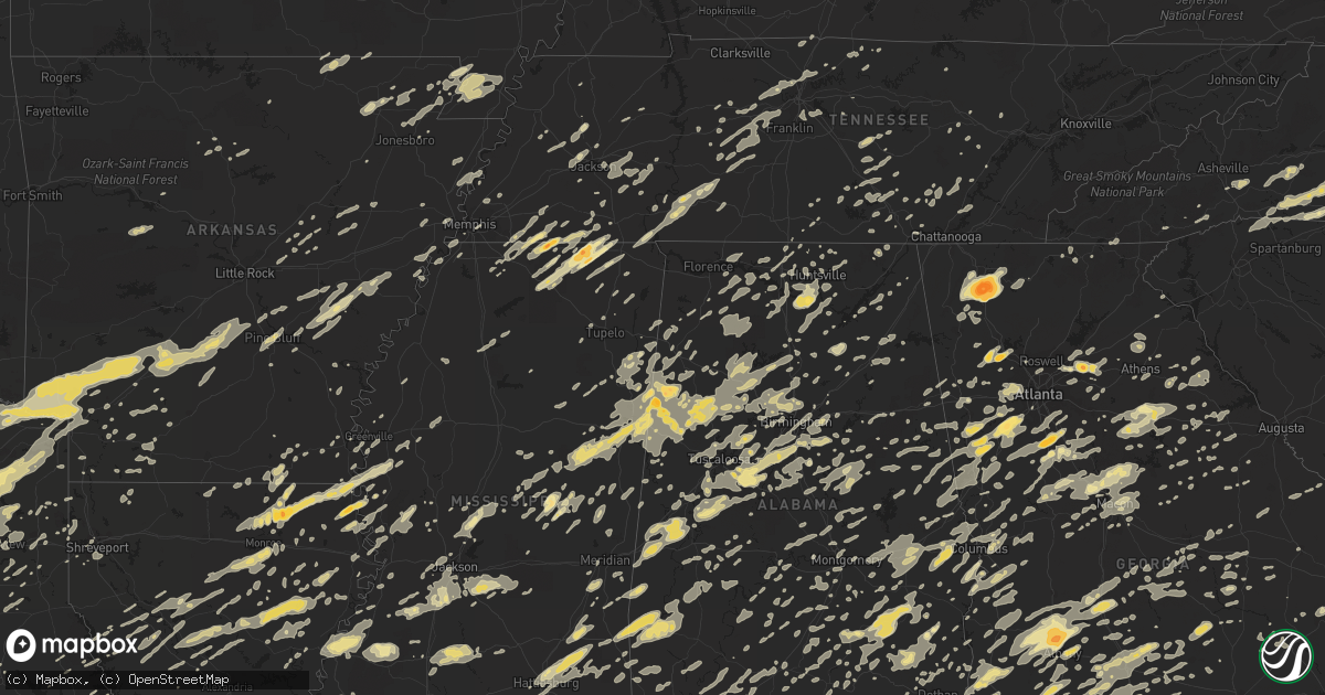
Hail Map in Alabama on April 4, 2011
Get this storm
April 4 map
$229
one time, instant access
Download today. No call, no setup
Keep the $229
Bought the map and want the full workflow? Apply the entire $229 to a subscription within 7 days. None of it is wasted.
Every map, not just this one
This buys you this map. Subscription and you get every map we run, in the markets you choose from a few cities to whole states to nationwide. Plus real-time alerts the moment a storm fires.
Contact data
Name, contact info, occupancy, even credit band for addresses in the footprint. You go from where it hit to who to call.
Become the source they trust
Unlimited branding weather history reports on demand. You already have the documented answer ready for the property owner, and you are the one who showed up with it.
Property data and RoofTrace estimates
Pull up any address you have got, its value and the exact code rules for that jurisdiction, straight from One Click Code. Then RoofTrace estimates the squares, pitch, and roof value, priced the way you price.
Storm reports in Alabama
Alabama
| Date | Description |
|---|---|
| 04/04/20116:53 PM CDT | Several tree limbs broken off trees. |
| 04/04/20116:51 PM CDT | A few trees were blown down near benevola in the southeastern part of the county. |
| 04/04/20116:38 PM CDT | Tree down on mocassin branch road |
| 04/04/20116:22 PM CDT | A few trees were blown down near curry. |
| 04/04/20116:20 PM CDT | A few trees were blown down around oakman. |
| 04/04/20116:20 PM CDT | Penny to quarter hail and winds estimated at 50 mph. |
| 04/04/20115:55 PM CDT | A gust of 60 mph was reported in the vinemont area at the auto auction one half of a mile from folsom field. |
| 04/04/20115:40 PM CDT | Public reported near golf ball size hail near valhermoso springs. Media relayed report. |
| 04/04/20115:36 PM CDT | A few trees were blown down across the northern part of the county. |
| 04/04/20115:25 PM CDT | A local report indicates 1.00 inch wind near 3 E VERNON |
| 04/04/20115:21 PM CDT | A local report indicates 1.50 inch wind near 4 W VERNON |
| 04/04/20115:21 PM CDT | A local report indicates 1.50 inch wind near STAR |
| 04/04/20115:02 PM CDT | A few trees were blown down in the national forest near grayson. |
| 04/04/20114:44 PM CDT | Box truck blown off sr17 just south of detroit |
| 04/04/20114:42 PM CDT | A local report indicates 1.00 inch wind near NW FAYETTE |
| 04/04/20114:33 PM CDT | A local report indicates 1.75 inch wind near VERNON |
| 04/04/20114:16 PM CDT | A local report indicates 1.50 inch wind near 4 W VERNON |
| 04/04/20114:15 PM CDT | A local report indicates 1.00 inch wind near DETROIT |
| 04/04/20114:15 PM CDT | A local report indicates 1.75 inch wind near 7 SW VERNON |
| 04/04/20114:15 PM CDT | A local report indicates 1.00 inch wind near 2 S DETROIT |
| 04/04/20114:15 PM CDT | Box truck blown off sr17 just south of detroit |
| 04/04/20114:15 PM CDT | Box truck blown off sr 17 just south of detroit |
| 04/04/20114:10 PM CDT | Hail ranging from 1/4 inch up to one inch in se huntsville. |
| 04/04/20114:10 PM CDT | 12 to 15 inch diameter tree blown down on mountain gap road. |
| 04/04/20114:04 PM CDT | Road signs along interstate 565 are blown down near research park. |
| 04/04/20113:53 PM CDT | Numerous trees and power lines down across downtown decatur. |
| 04/04/20113:40 PM CDT | Trees down on cr 358 in trinity. |
| 04/04/20113:37 PM CDT | A few trees were blown down along highway 19 near the franklin county line. |
| 04/04/20113:37 PM CDT | A few trees were blown down on highway 17 near the lamar county line. |
| 04/04/20113:30 PM CDT | Power pole and power lines down in downtown moulton. |
| 04/04/20113:27 PM CDT | Trees and power lines down at balch and gillespie roads in madison. |
| 04/04/20113:24 PM CDT | Trees down at the intersection of wall triana hwy and ready section road. |
| 04/04/20113:20 PM CDT | Trees down on west glenn valley road. |
| 04/04/20113:17 PM CDT | Several reports of roof damage and siding damage on benmark road |
| 04/04/20113:15 PM CDT | Several large trees between 8 and 20 inches in diameter blown down in st. Joseph. |
| 04/04/20113:07 PM CDT | A local report indicates 1.00 inch wind near TOWN CREEK |
| 04/04/20113:07 PM CDT | Power lines down on a tractor trailer |
| 04/04/20113:04 PM CDT | Two power poles blown down in town creek off hwy 101 south |
| 04/04/20113:00 PM CDT | Trees down at easter ferry at cabbage ridge road. |
| 04/04/20112:50 PM CDT | Multiple trees reported down along county road 93. Time estimated based on radar. |
| 04/04/20112:45 PM CDT | Two trees down 5 miles south of the lauderdale county line at the tennessee state line in western limestone county betweem salem and lester. |
| 04/04/20112:40 PM CDT | Spotter reports estimated 60 mph wind gust. Report relayed by amateur radio. |
| 04/04/20112:40 PM CDT | Multiple trees reported down along county road 93. Time estimated based on radar. |
| 04/04/20112:30 PM CDT | 52 knot gust measured at kmsl |
| 04/04/20111:57 PM CDT | Numerous trees blown down on the northern side of cherokee and the margerum areas. |
| 04/04/201112:15 AM CDT | Countywide trees and powerlines down. Trees falling on roofs. |
| 04/03/201111:58 PM CDT | *** 2 inj *** numerous trees down across the county. 10 structures damaged. 2 minor injuries from trees falling on homes. |
| 04/03/201111:52 PM CDT | *** 2 inj *** tree on a trailer. 2 minor injuries. Several reports of powerlines down in geneva |
| 04/03/201111:50 PM CDT | Several trees down on highway 431 |
| 04/03/201111:45 PM CDT | 10 to 15 trees reported down across the county. |
| 04/03/201111:40 PM CDT | Numerous trees down blocking roads throughout the county. Power outages also reported. |
| 04/03/201111:30 PM CDT | Numerous medium to large trees and power lines down. 1 home with structural damage. Northern part of town without power until this morning 04/05/11. |
| 04/03/201111:25 PM CDT | Tree fell on a home. |
| 04/03/201111:09 PM CDT | Several trees blown down in western barbour county. One landed on a home and caused considerable damage. |
| 04/03/201111:08 PM CDT | A tree was blown down in seale. |
| 04/03/201111:08 PM CDT | According to ema...multiple reports of trees and powerlines down near the town of florala. Time estimated from radar. |
| 04/03/201111:07 PM CDT | Several trees and powerlines down across the northern county. Time estimated by radar. |
| 04/03/201111:00 PM CDT | Power lines were blown down. |
| 04/03/201110:57 PM CDT | Several trees blown down in eastern pike county. |
| 04/03/201110:53 PM CDT | Several trees down across eastern pike county. Sr 93 has trees and limbs down on the roadway for a two mile stretch. |
| 04/03/201110:45 PM CDT | Some shingles and gutters blown off a home. Pine tree blown over. |
| 04/03/201110:40 PM CDT | Numerous trees and power lines down in troy. At least one tree fell on a house. |
| 04/03/201110:35 PM CDT | Several trees down in and around auburn. |
| 04/03/201110:15 PM CDT | A local report indicates 60 MPH wind near 3 SW TUSKEGEE |
| 04/03/201110:15 PM CDT | Escambia county 911 reported trees and power lines down near jacks bayou and muscogee road. One tree is reported on fire. |
| 04/03/201110:13 PM CDT | Nw of the town of gantt...ema reports several areas with fallen trees and powerlines. Time estimated from radar. |
| 04/03/201110:02 PM CDT | A local report indicates 1.00 inch wind near CORINTH |
| 04/03/201110:02 PM CDT | A local report indicates 1.00 inch wind near ROANOKE |
| 04/03/201110:02 PM CDT | A local report indicates 1.00 inch wind near WADLEY |
| 04/03/20119:56 PM CDT | Trees down on west bend rd. Time estimated from radar. |
| 04/03/20119:54 PM CDT | Ema reports several trees down at the intersection of hwy 97 and hwy 331. Time estimated from radar. |
| 04/03/20119:54 PM CDT | Power lines at hwy 331 and county road 66. Time estimated by radar. |
| 04/03/20119:52 PM CDT | Tree down on mobile home. Several trees down in central randolph county. |
| 04/03/20119:40 PM CDT | Estimated gusts near intersection of us 80 and us 231. |
| 04/03/20119:37 PM CDT | Tree fell on a trailer on wigwam way |
| 04/03/20119:33 PM CDT | Winds estimated |
| 04/03/20119:32 PM CDT | Several trees down in western randolph county. Some blocking roadways. |
| 04/03/20119:20 PM CDT | Mopd reports tree down on halls mill rd and mcvay dr...blocking traffic. Time estimated from radar. |
| 04/03/20119:19 PM CDT | A local report indicates 58 MPH wind near DEATSVILLE |
| 04/03/20119:16 PM CDT | Roof ripped off of a mobile home. Also widespread trees down around the county. |
| 04/03/20119:16 PM CDT | A few trees were blown down in southern lowndes county. One tree landed on a home. |
| 04/03/20119:06 PM CDT | Trees down |
| 04/03/20119:00 PM CDT | Top blown out of tree destroyed boat...major roof damage to mobile home. |
| 04/03/20119:00 PM CDT | Top blown out of tree destroyed boat...major roof damage to mobile home. |
| 04/03/20118:57 PM CDT | Numerous trees down around sylacauga including odenville and oak grove and tallasahatchie areas. |
| 04/03/20118:57 PM CDT | Trees and power lines were blown down along highway 41 in a few locations. A grass fire was caused by the downed power lines. |
| 04/03/20118:57 PM CDT | Tree down at shades crest and morgan road. |
| 04/03/20118:55 PM CDT | Tree on house blue spring rd |
| 04/03/20118:55 PM CDT | A local report indicates 61 MPH wind near SYLACAUGA |
| 04/03/20118:53 PM CDT | Trees down in clanton on highway 22 between 10th and 11th street. |
| 04/03/20118:53 PM CDT | Several trees down |
| 04/03/20118:52 PM CDT | Power lines down klien rd/sun valley |
| 04/03/20118:52 PM CDT | A tree was blown down near mt carmel church along highway 140. |
| 04/03/20118:50 PM CDT | Trees down in the jackson area on depot rd near elms st. |
| 04/03/20118:48 PM CDT | A tree was blown down along highway 22. |
| 04/03/20118:48 PM CDT | Ema reports several trees down near whatley. Time estimated from radar. |
| 04/03/20118:48 PM CDT | Ema reported tree down. Time estimated from radar. |
| 04/03/20118:45 PM CDT | Large tree limbs and branches down. Tree down on university south alabama campus in front of admin bldg. |
| 04/03/20118:45 PM CDT | Hwy 145/nine oaks drive tree down. |
| 04/03/20118:42 PM CDT | Tree on house blue spring rd |
| 04/03/20118:40 PM CDT | Tree down on hwy 43 in grove hill near chilton rd. Time estimated from radar. |
| 04/03/20118:37 PM CDT | Numerous trees down throughout the county |
| 04/03/20118:37 PM CDT | Trees and power lines down down on highway 28 and highway 61. |
| 04/03/20118:35 PM CDT | Ema reports near the community of liberty...halfway between thomasville and grove hill...a tree has fallen across old hwy 5. Time estimated from radar. |
| 04/03/20118:32 PM CDT | Tree down on ferry road and mt dixie road. |
| 04/03/20118:30 PM CDT | Hwy 12/carrington |
| 04/03/20118:28 PM CDT | Power lines down at ozley road and little rock road. |
| 04/03/20118:27 PM CDT | Ema reports tree and 3-phase power line damage. Time estimated from radar. |
| 04/03/20118:26 PM CDT | Trees down on mudd st |
| 04/03/20118:23 PM CDT | Tree down hwy 343/70 |
| 04/03/20118:17 PM CDT | Mccaig rd/hwy 77 trees down |
| 04/03/20118:13 PM CDT | A few trees were blown down in northern perry county. |
| 04/03/20118:09 PM CDT | Tree down at shades crest and morgan road. |
| 04/03/20118:07 PM CDT | Trees down on hwy 69 in salitpa...8 miles sse of coffeeville. Time estimated from radar. |
| 04/03/20118:07 PM CDT | Trees down on west bend rd. Time estimated from radar. |
| 04/03/20118:05 PM CDT | A few trees were blown down in southern marengo county. |
| 04/03/20118:05 PM CDT | A few trees were blown down in northern marengo county. |
| 04/03/20118:04 PM CDT | Tree down in the roadway near i-20 and shoal creek road. |
| 04/03/20118:00 PM CDT | A few trees were blown down along highway 61 between greensboro and newburn. |
| 04/03/20118:00 PM CDT | Tree down on south view drive |
| 04/03/20117:58 PM CDT | Trees down on highway 273 near yellow creek. |
| 04/03/20117:58 PM CDT | Trees and power lines down on altamont road. |
| 04/03/20117:50 PM CDT | Tree down on house on russell st. |
| 04/03/20117:45 PM CDT | Numerous trees down little wills creek campground |
| 04/03/20117:42 PM CDT | Tree down on fairview road. |
| 04/03/20117:41 PM CDT | Power outages. |
| 04/03/20117:40 PM CDT | Tree down on power pole with lines down at 6th ave east and stevens. |
| 04/03/20117:40 PM CDT | Trees and power lines down in the kilpatrick community along cr 386 |
| 04/03/20117:37 PM CDT | Tree down on a power line in ivalee community. Tree down on rocky hollow road. |
| 04/03/20117:35 PM CDT | Multiple trees reported down in the needham area. Reported by wtok. |
| 04/03/20117:33 PM CDT | Trees down on johns road and abernant ball park road. |
| 04/03/20117:33 PM CDT | Tree down on pine lake road/new river road. |
| 04/03/20117:28 PM CDT | Tree down on house |
| 04/03/20117:28 PM CDT | Trees down on cr 13 |
| 04/03/20117:26 PM CDT | Tree down in livingston. |
| 04/03/20117:25 PM CDT | Tree down on near cr 10 and cr 27 |
| 04/03/20117:25 PM CDT | Tree down on cr 42 |
| 04/03/20117:25 PM CDT | Tree down on near cr 10 and sr 17 |
| 04/03/20117:23 PM CDT | Tree down blocking the roadway in mountainboro. Another tree down on duck springs road. One tree down on sardis road. |
| 04/03/20117:23 PM CDT | Tree down in ballplay on gowens road and fords valley road. |
| 04/03/20117:22 PM CDT | Tree down on cr 19 |
| 04/03/20117:19 PM CDT | Tree debris acrs hwy 79 |
| 04/03/20117:15 PM CDT | Multiple trees down across oakman parrish road/4700. Trees down on pine street. |
| 04/03/20117:15 PM CDT | Material from a barn and part of its roof blown off along with a large tree uprooted. Time estimated from radar. |
| 04/03/20117:12 PM CDT | Choctaw county sheriff reported that numerous trees down between 712 pm and 810 pm. Widespread trees down across the county. Time estimated from radar when the three ce |
| 04/03/20117:10 PM CDT | Tree down on mocassin branch road |
| 04/03/20117:08 PM CDT | Tree down on mt olive road/cr 23. |
| 04/03/20117:04 PM CDT | Tree down on mt olive road/cr 23. |
All States Impacted by Hail Map on April 4, 2011
Cities Impacted by Hail Map on April 4, 2011
- Longview, TX
- Denmark, TN
- Medon, TN
- Crossville, TN
- Noble, LA
- Converse, LA
- Selmer, TN
- Boaz, AL
- Horton, AL
- Altoona, AL
- Jewell, GA
- Bloomington, IN
- Midland City, AL
- Ozark, AL
- Quitman, MS
- Meridian, MS
- Norman, IN
- Louisville, MS
- Weir, MS
- McCool, MS
- Clarendon, AR
- Casscoe, AR
- Almyra, AR
- Stuttgart, AR
- Crocketts Bluff, AR
- Delta, AL
- Woodville, TX
- Campti, LA
- Marietta, GA
- Eminence, MO
- Ethelsville, AL
- Ozan, AR
- Antoine, AR
- Okolona, AR
- Hooks, TX
- Blevins, AR
- Nashville, AR
- Alleene, AR
- Murfreesboro, AR
- De Kalb, TX
- Prescott, AR
- Delight, AR
- Ogden, AR
- Foreman, AR
- Saratoga, AR
- Texarkana, TX
- McCaskill, AR
- Ashdown, AR
- New Boston, TX
- Lockesburg, AR
- Avery, TX
- Columbus, AR
- Mineral Springs, AR
- Wilton, AR
- Evergreen, AL
- Fletcher, NC
- Buford, GA
- Hoschton, GA
- Flowery Branch, GA
- Auburn, GA
- Braselton, GA
- Mayo, FL
- Horseshoe Beach, FL
- Live Oak, FL
- Branford, FL
- Perry, FL
- Steinhatchee, FL
- Salem, FL
- Day, FL
- Old Town, FL
- Luverne, AL
- Goshen, AL
- Pine Bluff, AR
- Sherrill, AR
- Nashville, IN
- Ashland, AL
- Seneca, SC
- Ponce De Leon, FL
- Shreveport, LA
- Bradley, AR
- Taylor, AR
- Lafe, AR
- Rector, AR
- Marmaduke, AR
- Milam, TX
- Beallsville, OH
- Powhatan Point, OH
- Alledonia, OH
- Jacobsburg, OH
- Port Richey, FL
- New Port Richey, FL
- Hudson, FL
- Spring Hill, FL
- Lake Toxaway, NC
- Ponchatoula, LA
- Kane, PA
- Lewis Run, PA
- Warren, PA
- Tiona, PA
- Clarendon, PA
- Melville, LA
- Plaucheville, LA
- Palmetto, LA
- Milledgeville, TN
- Sardis, TN
- Bluffton, SC
- Lexington, GA
- Stephens, GA
- Bainbridge, GA
- Pontotoc, MS
- Centreville, AL
- Duncanville, AL
- Brent, AL
- West Blocton, AL
- Boligee, AL
- Livingston, AL
- Olivehill, TN
- Baileyton, AL
- Cullman, AL
- Huntsville, AL
- Union Grove, AL
- Somerville, AL
- Laceys Spring, AL
- Vinemont, AL
- New Hope, AL
- Eva, AL
- Canton, TX
- Leesburg, TX
- Mineola, TX
- Hughes Springs, TX
- Pittsburg, TX
- Quitman, TX
- Daingerfield, TX
- Hawkins, TX
- Naples, TX
- Como, TX
- Big Sandy, TX
- Gilmer, TX
- Omaha, TX
- Winnsboro, TX
- Atlanta, GA
- Shiloh, GA
- Hamilton, GA
- Cataula, GA
- Warm Springs, GA
- Jacksons Gap, AL
- Dadeville, AL
- Marion Junction, AL
- Uniontown, AL
- Wilsonville, AL
- Adger, AL
- Bessemer, AL
- Vance, AL
- Pelham, AL
- Knoxville, AL
- Alabaster, AL
- Brierfield, AL
- Fosters, AL
- Sterrett, AL
- Tuscaloosa, AL
- Birmingham, AL
- Harpersville, AL
- Moundville, AL
- Akron, AL
- Helena, AL
- Montevallo, AL
- Cottondale, AL
- Chelsea, AL
- Vincent, AL
- Columbiana, AL
- Brookwood, AL
- McCalla, AL
- Woodstock, AL
- Williams, IN
- Guntersville, AL
- Midland, GA
- Collierville, TN
- Williston, TN
- Somerville, TN
- Rossville, TN
- Moscow, TN
- Barlow, KY
- Greensboro, GA
- Madison, GA
- Dayton, OH
- Longs, SC
- Conway, SC
- Loris, SC
- Adamsville, AL
- Monroe, LA
- Ethel, MS
- Kosciusko, MS
- Trinity, AL
- Moulton, AL
- Hillsboro, AL
- Andalusia, AL
- Red Level, AL
- Gordo, AL
- Steens, MS
- Sulligent, AL
- Bankston, AL
- Oakman, AL
- Parrish, AL
- Crane Hill, AL
- Caledonia, MS
- Arley, AL
- Beaverton, AL
- Double Springs, AL
- Reform, AL
- Berry, AL
- Millport, AL
- Aberdeen, MS
- Hanceville, AL
- Nauvoo, AL
- Bremen, AL
- Jasper, AL
- Sturgis, MS
- Carbon Hill, AL
- Brooksville, MS
- Starkville, MS
- Houston, AL
- Kennedy, AL
- Greenwood Springs, MS
- Gattman, MS
- Carrollton, AL
- West Point, MS
- Detroit, AL
- Cordova, AL
- Hamilton, MS
- Fayette, AL
- Northport, AL
- Vernon, AL
- Columbus, MS
- Townley, AL
- Crawford, MS
- Robeline, LA
- Marthaville, LA
- Brickeys, AR
- Marianna, AR
- Tunica, MS
- Isola, MS
- Inverness, MS
- Leland, MS
- Greenville, MS
- Colfax, LA
- Dry Prong, LA
- Magnolia, AR
- McNeil, AR
- Petersburg, TN
- Bremen, GA
- Temple, GA
- Carrollton, GA
- Clay, KY
- Winfield, AL
- Eldridge, AL
- Shubuta, MS
- Marksville, LA
- Hessmer, LA
- Newnan, GA
- Palmetto, GA
- Fairburn, GA
- Sharpsburg, GA
- Chidester, AR
- Homerville, GA
- Thomaston, AL
- Bogata, TX
- De Kalb, MS
- Hawkinsville, GA
- Eastman, GA
- Coal Center, PA
- Daisytown, PA
- Clayton, AL
- Vale, NC
- Lincolnton, NC
- Florence, MS
- Bastrop, LA
- Hilliard, FL
- Humboldt, TN
- Trenton, TN
- De Berry, TX
- Bethany, LA
- Hackleburg, AL
- Hamilton, AL
- Union Springs, AL
- Troy, AL
- Grady, AL
- Wind Ridge, PA
- Cameron, WV
- Glen Easton, WV
- Hornbeck, LA
- Tutwiler, MS
- Thornton, TX
- Groesbeck, TX
- Fairfield, TX
- Teague, TX
- Donie, TX
- Franklin, GA
- Douglasville, GA
- Whitesburg, GA
- Roopville, GA
- San Augustine, TX
- Palmer, TN
- Milton, FL
- Holt, FL
- Millington, TN
- Childersburg, AL
- Alpine, AL
- Louisville, GA
- Stapleton, GA
- Ariton, AL
- Long Branch, TX
- Mount Enterprise, TX
- Tifton, GA
- Montville, OH
- Chardon, OH
- Faunsdale, AL
- Linden, AL
- Saint Albans, WV
- Tornado, WV
- Camilla, GA
- Ellisville, MS
- Ovett, MS
- Petal, MS
- Hattiesburg, MS
- Richton, MS
- Waynesboro, MS
- Moselle, MS
- Laurel, MS
- Hartford, AL
- Slocomb, AL
- Albany, GA
- Sylvester, GA
- Crofton, KY
- White Plains, KY
- Gadsden, AL
- Lawrenceville, GA
- Kennett, MO
- Mooresboro, NC
- Shelby, NC
- Gaffney, SC
- Lewisville, AR
- Hull, GA
- Nicholson, GA
- Commerce, GA
- Merom, IN
- Hutsonville, IL
- Sullivan, IN
- Fairbanks, IN
- Mayersville, MS
- Lake Providence, LA
- Lawndale, NC
- Cherryville, NC
- Acworth, GA
- Dallas, GA
- Graysville, AL
- Shelbyville, IN
- Fargo, GA
- Hogansville, GA
- Ash, NC
- Bolton, NC
- Mount Olive, AL
- Clarkson, KY
- Cub Run, KY
- Munfordville, KY
- Panama City, FL
- Lindale, TX
- Tyler, TX
- Winona, TX
- Morgantown, KY
- Belton, KY
- Dunmor, KY
- Lewisburg, KY
- Guthrie, KY
- Elkton, KY
- Branchland, WV
- Weogufka, AL
- Sylacauga, AL
- Hendersonville, TN
- Germantown, OH
- La Grange, TN
- Lamar, MS
- Michigan City, MS
- Byhalia, MS
- Red Banks, MS
- Holly Springs, MS
- Grand Junction, TN
- Blakely, GA
- Horse Cave, KY
- Cave City, KY
- Bowling Green, KY
- Cory, IN
- Clay City, IN
- Pimento, IN
- Lewis, IN
- Huntingdon, TN
- Hollow Rock, TN
- Bruceton, TN
- Griffin, GA
- Williamson, GA
- Opp, AL
- Kite, GA
- Adrian, GA
- Dover, AR
- Harrison, TN
- Soddy Daisy, TN
- Greer, SC
- Landrum, SC
- Taylors, SC
- Philadelphia, MS
- Gray, GA
- Haddock, GA
- Juliette, GA
- Hillsboro, GA
- Forsyth, GA
- Macon, GA
- Mocksville, NC
- Newellton, LA
- Tallulah, LA
- Leeds, AL
- Coal City, IN
- Freedom, IN
- Spencer, IN
- Gosport, IN
- Ellettsville, IN
- Worthington, IN
- Wadley, AL
- Natchez, MS
- Lecanto, FL
- Hernando, FL
- Inverness, FL
- Homosassa, FL
- Oneonta, AL
- Tiplersville, MS
- Transylvania, LA
- Cary, MS
- Sondheimer, LA
- Rolling Fork, MS
- Diana, TX
- Avinger, TX
- Ore City, TX
- Jefferson, TX
- Valhermoso Springs, AL
- Butler, AL
- Dacula, GA
- Austin, TX
- Leander, TX
- Cedar Park, TX
- Uvalda, GA
- Lyons, GA
- Thomasville, GA
- Hampton, GA
- Mcdonough, GA
- Locust Grove, GA
- Hazlehurst, GA
- West Green, GA
- Denton, GA
- Monticello, FL
- Dunlap, TN
- Natchitoches, LA
- Fayette, MS
- Ferriday, LA
- Fort Benning, GA
- Wing, AL
- Brantley, AL
- Rutledge, AL
- Nebo, NC
- Union Mills, NC
- Morganton, NC
- Valley Mills, TX
- Crawford, TX
- Vienna, GA
- Cordele, GA
- Miamisburg, OH
- Blountsville, AL
- Armuchee, GA
- Rome, GA
- Calhoun, GA
- McCrory, AR
- Augusta, AR
- Yazoo City, MS
- Yantis, TX
- Sulphur Springs, TX
- Opelika, AL
- Salem, AL
- Hatchechubbee, AL
- Seale, AL
- Hurtsboro, AL
- Phenix City, AL
- Honoraville, AL
- Terre Haute, IN
- Farmersburg, IN
- Bells, TN
- Jackson, TN
- Winnsboro, LA
- Fort Necessity, LA
- South Park, PA
- Clairton, PA
- Finleyville, PA
- Waverly Hall, GA
- Greenville, FL
- Makanda, IL
- Alto Pass, IL
- Carbondale, IL
- Cobden, IL
- Hayneville, AL
- Tyler, AL
- East Prairie, MO
- Matthews, MO
- Ellenboro, NC
- Rockdale, TX
- Thorndale, TX
- Town Creek, AL
- Sterlington, LA
- Farmerville, LA
- Waycross, GA
- Leesburg, GA
- Smithville, GA
- Bronwood, GA
- Dawson, GA
- Suwanee, GA
- Greensburg, IN
- Crossett, AR
- Hamburg, AR
- Gerton, NC
- Fairview, NC
- Hendersonville, NC
- Black Mountain, NC
- Sumner, GA
- Newport, AR
- Marietta, TX
- Palestine, TX
- Arp, TX
- Gladewater, TX
- Fruitvale, TX
- Grand Saline, TX
- Linden, TX
- Edgewood, TX
- Douglassville, TX
- Lone Star, TX
- Flint, TX
- Brownsboro, TX
- Alba, TX
- Athens, TX
- Whitehouse, TX
- Ben Wheeler, TX
- Chandler, TX
- Frankston, TX
- Wills Point, TX
- Larue, TX
- Tennessee Colony, TX
- Emory, TX
- Bullard, TX
- Van, TX
- Montalba, TX
- Scroggins, TX
- Carthage, MS
- Lumpkin, GA
- Cusseta, GA
- Richland, GA
- Talco, TX
- Mount Pleasant, TX
- Mount Vernon, TX
- Calera, AL
- Poulan, GA
- Indianapolis, IN
- Greenwood, IN
- Fairland, IN
- Needham, IN
- Boggstown, IN
- Georgetown, GA
- Athens, AL
- Elkmont, AL
- Middleton, TN
- Graceville, FL
- Waco, GA
- Deridder, LA
- New Castle, IN
- Whiteland, IN
- Eatonton, GA
- Buckhead, GA
- La Center, KY
- Kevil, KY
- Chatsworth, GA
- Dalton, GA
- Sugar Valley, GA
- Resaca, GA
- Ashland, MS
- Collinston, LA
- Mer Rouge, LA
- Crystal Springs, MS
- Hermanville, MS
- Utica, MS
- Hazlehurst, MS
- Scipio, IN
- Golconda, IL
- Fort Mitchell, AL
- Hickory Flat, MS
- Potts Camp, MS
- Granger, TX
- Taylor, TX
- Georgetown, TX
- Aquilla, TX
- China Spring, TX
- Whitney, TX
- Clifton, TX
- Ventress, LA
- Aliceville, AL
- Marion, KY
- Addison, AL
- Russellville, AL
- Danville, AL
- Haleyville, AL
- Belle Rose, LA
- Madison, FL
- Waldo, AR
- Forest, MS
- Raleigh, MS
- Silsbee, TX
- Marbury, AL
- Equality, AL
- Rockford, AL
- Titus, AL
- Deatsville, AL
- Kilgore, TX
- Sparkman, AR
- Clarksville, TX
- Annona, TX
- Eustace, TX
- Overton, TX
- Murchison, TX
- Haworth, OK
- White Oak, TX
- Maud, TX
- Dike, TX
- Prattsville, AR
- Jacksonville, TX
- Jewett, TX
- Saltillo, TX
- Queen City, TX
- Kaufman, TX
- Mexia, TX
- Horatio, AR
- Donaldson, AR
- Leola, AR
- Gurdon, AR
- Atlanta, TX
- Texarkana, AR
- Arkadelphia, AR
- Grapevine, AR
- Fulton, AR
- Pickton, TX
- Nash, TX
- Cookville, TX
- Sheridan, AR
- Hallsville, TX
- Carthage, AR
- Tallahassee, FL
- Phil Campbell, AL
- Gatewood, MO
- Woodbury, TN
- Many, LA
- Louisville, AL
- Letohatchee, AL
- Lowndesboro, AL
- Hope Hull, AL
- Coker, AL
- Buhl, AL
- Linesville, PA
- Vaughan, MS
- Lebanon, TN
- Goodlettsville, TN
- Fredonia, KY
- Tichnor, AR
- Jackson, GA
- Alberta, AL
- Catherine, AL
- Youngstown, FL
- Woodland, AL
- Muscadine, AL
- Tallapoosa, GA
- Buchanan, GA
- Madison, AL
- Nashville, TN
- Madison, TN
- Duck River, TN
- Centerville, TN
- Midway, FL
- Quincy, FL
- Havana, FL
- Dry Creek, LA
- Huron, TN
- Pinson, TN
- Henderson, TN
- Beech Bluff, TN
- Luray, TN
- Lexington, TN
- Ray City, GA
- Hilton Head Island, SC
- Pulaski, MS
- Tatum, TX
- Henderson, TX
- Dry Branch, GA
- Greensburg, LA
- Savannah, TN
- Lynn, AL
- Cartersville, GA
- Hemphill, TX
- Lake Park, GA
- Valdosta, GA
- Forest City, NC
- Bostic, NC
- Rutherfordton, NC
- Spindale, NC
- Belle Vernon, PA
- Waynesburg, PA
- Scenery Hill, PA
- Prosperity, PA
- Richeyville, PA
- Fredericktown, PA
- Dunlevy, PA
- Monessen, PA
- Beallsville, PA
- Amity, PA
- Marianna, PA
- Charleroi, PA
- Williamsville, MO
- Ludowici, GA
- Ashland City, TN
- Steele, AL
- Wedowee, AL
- Lineville, AL
- Cragford, AL
- Toxey, AL
- Gilbertown, AL
- Millry, AL
- Frankville, AL
- Sweet Water, AL
- Thomasville, AL
- Silas, AL
- Campbell, AL
- Coffeeville, AL
- Bogue Chitto, MS
- Doerun, GA
- Hartsfield, GA
- Omega, GA
- Ocilla, GA
- Norman Park, GA
- Chula, GA
- Fitzgerald, GA
- Funston, GA
- Moultrie, GA
- Meigs, GA
- Ty Ty, GA
- Grand Ridge, FL
- Marianna, FL
- Manchester, TN
- Tullahoma, TN
- Dora, AL
- Lake City, FL
- Ailey, GA
- Mount Vernon, GA
- Tarrytown, GA
- Vidalia, GA
- Eddyville, KY
- Shellman, GA
- Beebe, AR
- Brookhaven, MS
- Bronson, TX
- Bonifay, FL
- West Monroe, LA
- Estill Springs, TN
- Canonsburg, PA
- Washington, PA
- McEwen, TN
- Dickson, TN
- Hollandale, MS
- Rienzi, MS
- Corinth, MS
- Dixie, GA
- Earle, AR
- Sarepta, LA
- Oak Grove, LA
- Camden, MS
- Mendenhall, MS
- Pelahatchie, MS
- Brandon, MS
- Braxton, MS
- Rebecca, GA
- Sycamore, GA
- Odum, GA
- Kuttawa, KY
- Minter, AL
- Saulsbury, TN
- Walnut, MS
- Wiggins, MS
- Brooklyn, MS
- Lake Village, AR
- Lucedale, MS
- McLain, MS
- Peachtree City, GA
- Roanoke, AL
- Union City, GA
- Lanett, AL
- Lagrange, GA
- Cusseta, AL
- Lafayette, AL
- Tyrone, GA
- Five Points, AL
- Senoia, GA
- Grantville, GA
- Fayetteville, GA
- Moreland, GA
- Sandersville, GA
- Beatrice, AL
- Pine Apple, AL
- New Market, AL
- Graysville, TN
- Dayton, TN
- Pikeville, TN
- Sale Creek, TN
- Lake City, AR
- Buena Vista, GA
- Eudora, AR
- Liberty, SC
- Easley, SC
- Brookland, AR
- Paragould, AR
- Jonesboro, AR
- Chester, IL
- Ellis Grove, IL
- Saint Mary, MO
- Cuba, AL
- York, AL
- Naylor, GA
- Terry, MS
- Springfield, TN
- Orlinda, TN
- Bedford, IN
- Wetumpka, AL
- Eclectic, AL
- Mantee, MS
- Mathiston, MS
- Maben, MS
- Eupora, MS
- Annapolis, IL
- Palestine, IL
- Shelburn, IN
- Robinson, IL
- West York, IL
- Quitman, GA
- Chunchula, AL
- Citronelle, AL
- Stockbridge, GA
- Jonesboro, GA
- Rex, GA
- Laurel Hill, FL
- Florala, AL
- Scurry, TX
- Vidalia, LA
- Pollock, LA
- Trout, LA
- Counce, TN
- Andrews, SC
- Waynesboro, TN
- Clifton, TN
- Hohenwald, TN
- North Augusta, SC
- Jasper, TX
- Prattville, AL
- Jesup, GA
- Carthage, IN
- Knightstown, IN
- Morristown, IN
- Greenfield, IN
- Arlington, IN
- Dozier, AL
- Angie, LA
- Goodwater, AL
- Ararat, VA
- Meadows Of Dan, VA
- Laurel Fork, VA
- Hillsville, VA
- Reynolds, GA
- Doniphan, MO
- Watertown, TN
- Heth, AR
- Widener, AR
- Bunkie, LA
- Baconton, GA
- Newton, GA
- Booneville, MS
- Loranger, LA
- Folsom, LA
- Arlington, AL
- Pine Hill, AL
- Dixons Mills, AL
- Magnolia, AL
- Manor, TX
- Tabor City, NC
- Glenville, NC
- Cashiers, NC
- Milano, TX
- Cameron, TX
- Buckholts, TX
- Davilla, TX
- Clarington, OH
- Bragg City, MO
- Mitchell, GA
- Warrenton, GA
- Boston, GA
- Kings Mountain, NC
- Wisner, LA
- Glenwood, GA
- Alexandria, LA
- Woodworth, LA
- Lecompte, LA
- Westville, FL
- Clio, AL
- Jena, LA
- Grayson, LA
- Columbia, LA
- Pensacola, FL
- Robertsdale, AL
- Princeton, KY
- Freeport, FL
- Union, MS
- Dongola, IL
- Cuthbert, GA
- Coleman, GA
- Coolidge, GA
- Ochlocknee, GA
- Smithville, MS
- Fountain, FL
- Defuniak Springs, FL
- Amory, MS
- Nakina, NC
- Delco, NC
- Whiteville, NC
- Sweeden, KY
- Bee Spring, KY
- Mammoth Cave, KY
- Saint Stephen, SC
- Bonneau, SC
- Pocahontas, TN
- Ripley, MS
- Falkner, MS
- Tignall, GA
- Washington, GA
- Rayle, GA
- Campobello, SC
- Clarksville, FL
- Lisman, AL
- Columbia, MS
- Sandy Hook, MS
- Warner Robins, GA
- Altheimer, AR
- Wabbaseka, AR
- Hurricane, WV
- Hamlin, WV
- Dunbar, WV
- Griffithsville, WV
- Sod, WV
- Nitro, WV
- Alum Creek, WV
- Omaha, GA
- Griffithville, AR
- Covington, GA
- McDavid, FL
- Tanner, AL
- Donalsonville, GA
- Gordon, AL
- Jakin, GA
- Colquitt, GA
- Comer, GA
- Colbert, GA
- Danielsville, GA
- Monroe City, IN
- Hillsboro, TN
- Bartow, GA
- Highland Home, AL
- McClellandtown, PA
- Cotton Valley, LA
- Pitkin, LA
- Leesville, LA
- Elmer, LA
- Fort Polk, LA
- Glenmora, LA
- Hineston, LA
- Powder Springs, GA
- Lithia Springs, GA
- Mableton, GA
- Austell, GA
- Clarkdale, GA
- Mansfield, GA
- Bonnieville, KY
- Rockville, IN
- Montezuma, IN
- Crestview, FL
- Eglin Afb, FL
- Canton, MS
- Pine Mountain, GA
- Denham Springs, LA
- Walker, LA
- Vina, AL
- Hodges, AL
- Fordsville, KY
- Hartford, KY
- Washington, AR
- Sparta, TN
- Waverly, AL
- Auburn, AL
- Newton, NC
- Mooresville, NC
- Maiden, NC
- Crouse, NC
- Troutman, NC
- Columbus, NC
- Tryon, NC
- Statesville, NC
- Claremont, NC
- Mill Spring, NC
- Sherrills Ford, NC
- Terrell, NC
- Catawba, NC
- Westmoreland, TN
- Hartsville, TN
- Lafayette, TN
- Bethpage, TN
- Saluda, SC
- Edgefield, SC
- Shuqualak, MS
- Auburn, KY
- Jasper, FL
- Belton, SC
- Honea Path, SC
- Winston, GA
- Villa Rica, GA
- Epps, LA
- Pioneer, LA
- Plainville, GA
- Newville, AL
- Eros, LA
- Forkland, AL
- Bellamy, AL
- Epes, AL
- Butler, GA
- Roberta, GA
- Pittsview, AL
- Courtland, MS
- Oakland, MS
- Enid, MS
- Pope, MS
- Dardanelle, AR
- Danville, AR
- Belleville, AR
- Woodleaf, NC
- East Dublin, GA
- Dublin, GA
- Blairsville, GA
- Mason, IL
- Oblong, IL
- Jasonville, IN
- West Union, IL
- Willow Hill, IL
- Newton, IL
- Hymera, IN
- Yale, IL
- Coalmont, IN
- Wheeler, IL
- Dieterich, IL
- Lawrenceburg, TN
- Paris, IL
- Climax, GA
- Chatham, LA
- Jonesboro, LA
- Emelle, AL
- Bascom, FL
- Centerpoint, IN
- Poland, IN
- Eufaula, AL
- Banks, AL
- Memphis, TN
- Thomson, GA
- Pitts, GA
- Rochelle, GA
- Ashburn, GA
- Arabi, GA
- Central, SC
- Union Church, MS
- Roxie, MS
- Meadville, MS
- McCall Creek, MS
- Vienna, IL
- Washington, IN
- Portland, AR
- Montrose, AR
- Marlin, TX
- Doddridge, AR
- Cadiz, KY
- Sparta, GA
- Cobbtown, GA
- Pelham, TN
- Altamont, TN
- Inglis, FL
- Cedar Key, FL
- Chiefland, FL
- Rockfield, KY
- Tylertown, MS
- Mount Hermon, LA
- Franklinton, LA
- Weston, GA
- Coushatta, LA
- Pelican, LA
- Clinton, IN
- Clinton, MS
- Bolton, MS
- Jackson, MS
- Thorsby, AL
- Jemison, AL
- Clanton, AL
- Kimberly, AL
- Mulga, AL
- Fultondale, AL
- Gardendale, AL
- Quinton, AL
- Sumiton, AL
- Warrior, AL
- Empire, AL
- Trafford, AL
- Morris, AL
- Brookside, AL
- Hayden, AL
- Irvington, AL
- West Point, GA
- Hahira, GA
- Morven, GA
- Rushville, IN
- Cowan, TN
- Decherd, TN
- Bivins, TX
- Vivian, LA
- Mountain View, AR
- Fox, AR
- Clinton, AR
- Shirley, AR
- Nashville, GA
- Newton, AL
- Waskom, TX
- Mooringsport, LA
- Montgomery, IN
- Loogootee, IN
- Cannelburg, IN
- Petersburg, IN
- Mangham, LA
- Broxton, GA
- Cairo, GA
- Seminole, AL
- Elberta, AL
- Moody, AL
- Pell City, AL
- Damascus, GA
- Noxapater, MS
- Morgantown, IN
- Anderson, SC
- Wrightsville, GA
- Rayville, LA
- Whites Creek, TN
- Spruce Pine, AL
- Attapulgus, GA
- Troy, SC
- McCormick, SC
- Mount Carmel, IL
- Bone Gap, IL
- Toomsboro, GA
- Olla, LA
- Enterprise, LA
- Harrisonburg, LA
- Jerusalem, OH
- Graham, AL
- Jenkinsburg, GA
- Flovilla, GA
- Jasper, TN
- Bethlehem, GA
- Winder, GA
- Brewton, AL
- Bethesda, OH
- Belmont, OH
- Hickory Ridge, AR
- Wynne, AR
- Oran, MO
- Nacogdoches, TX
- Cottondale, FL
- Alford, FL
- Hope, AR
- Enville, TN
- Jacks Creek, TN
- Nineveh, IN
- Franklin, IN
- Trafalgar, IN
- Columbus, GA
- Sequatchie, TN
- Bentleyville, PA
- Eighty Four, PA
- Batesville, MS
- Oxford, MS
- Water Valley, MS
- Hornsby, TN
- Altha, FL
- Baxley, GA
- Stevenson, AL
- Livingston, TN
- Beech Grove, AR
- Delaplaine, AR
- Columbia, AL
- Holden, LA
- Sawyerville, AL
- Shorterville, AL
- Abbeville, AL
- Ider, AL
- Henagar, AL
- Morganfield, KY
- Thebes, IL
- McRae Helena, GA
- Singer, LA
- Hernando, MS
- Coldwater, MS
- Mount Carmel, SC
- Sylvania, GA
- Girard, GA
- Woolwine, VA
- Willis, VA
- Floyd, VA
- Fancy Gap, VA
- Evergreen, LA
- Washington, LA
- Morrow, LA
- Brockwell, AR
- Finger, TN
- Bethel Springs, TN
- Marion, AL
- Adel, GA
- Covington, LA
- Union Point, GA
- White Plains, GA
- Rutledge, GA
- Shady Dale, GA
- Monticello, GA
- Newborn, GA
- Bradley, SC
- Monroe, GA
- Hutto, TX
- Pflugerville, TX
- Roundhill, KY
- Port Saint Joe, FL
- Saint George, GA
- Dunnellon, FL
- Crystal River, FL
- Ocala, FL
- Toney, AL
- Buckner, AR
- Heflin, AL
- Fruithurst, AL
- Glenwood, IN
- Bristol, FL
- Couch, MO
- Greenville, AL
- Brevard, NC
- Surrency, GA
- La Fayette, GA
- Ranger, GA
- Summerville, GA
- Greenville, KY
- Rochester, KY
- Greensboro, AL
- Pearl, MS
- Cadwell, GA
- Searcy, AR
- Fountaintown, IN
- New Palestine, IN
- Marion, LA
- Lowgap, NC
- Mount Airy, NC
- Humnoke, AR
- Ulm, AR
- Carlisle, AR
- Cotton Plant, AR
- Walnut Ridge, AR
- Portia, AR
- Hoxie, AR
- Millerville, AL
- Arab, AL
- Merryville, LA
- Montgomery, AL
- Gibson, GA
- Pearson, GA
- Willacoochee, GA
- Henderson, KY
- Courtland, AL
- Centreville, MS
- Houston, MS
- Prairie, MS
- Brundidge, AL
- Marion, NC
- Lake Lure, NC
- Randolph, AL
- Brooks, GA
- Luthersville, GA
- Whitwell, TN
- Duluth, GA
- Guin, AL
- Delhi, LA
- Pavo, GA
- Farina, IL
- Twin City, GA
- Soperton, GA
- Swainsboro, GA
- Tuskegee, AL
- Jones, LA
- Glen Allan, MS
- Chatham, MS
- Bonita, LA
- Williamsport, TN
- Bon Aqua, TN
- Fairview, TN
- Primm Springs, TN
- Lyles, TN
- Santa Fe, TN
- Franklin, TN
- Kingston Springs, TN
- Nunnelly, TN
- Okolona, MS
- Sebree, KY
- Calhoun, KY
- Tickfaw, LA
- Hammond, LA
- Chauncey, GA
- White Springs, FL
- Qulin, MO
- Ashley, IL
- Woodlawn, IL
- Mount Vernon, IL
- Mount Hope, AL
- Rainbow City, AL
- Des Arc, AR
- Piedmont, AL
- Charleston, MO
- Carlton, GA
- Lamont, FL
- Ravenden Springs, AR
- Myrtle, MO
- Ravenden, AR
- Mammoth Spring, AR
- Pocahontas, AR
- Hardy, AR
- Valley Park, MS
- Cantonment, FL
- Eutaw, AL
- Blue Mountain, MS
- Ramer, TN
- Enterprise, MS
- Dearing, GA
- Charlottesville, IN
- Wilkinson, IN
- Shirley, IN
- De Valls Bluff, AR
- Roe, AR
- Liberty, IN
- Normandy, TN
- Wartrace, TN
- Raeford, NC
- Readyville, TN
- Liberty, TN
- Smithville, TN
- Duncan, SC
- Wellford, SC
- Fort Deposit, AL
- Loganville, GA
- Forest Home, AL
- Kingston, GA
- Taylorsville, GA
- Attalla, AL
- Gallant, AL
- Smithland, KY
- Burna, KY
- Musella, GA
- Knoxville, GA
- Glennville, GA
- Freetown, IN
- Shadyside, OH
- Wheeling, WV
- Valley Grove, WV
- Claysville, PA
- Glen Dale, WV
- Benwood, WV
- Triadelphia, WV
- Mcmechen, WV
- West Alexander, PA
- Safford, AL
- Longville, LA
- Hughes, AR
- Rogersville, AL
- Killen, AL
- Rocky Face, GA
- Leighton, AL
- Monticello, MS
- Sontag, MS
- Silver Creek, MS
- Prentiss, MS
- Jayess, MS
- Brownsville, IN
- Dixon, KY
- Claxton, GA
- Collins, GA
- Greenway, AR
- Piggott, AR
- Holcomb, MO
- Campbell, MO
- Gretna, FL
- Deer Park, AL
- McIntosh, AL
- Preston, MS
- Dundee, KY
- Fort Valley, GA
- Wrens, GA
- Rockmart, GA
- Barney, GA
- Emerson, AR
- Lakeland, GA
- Crawfordville, FL
- Box Springs, GA
- Ellerslie, GA
- Upatoi, GA
- Smiths Station, AL
- Tibbie, AL
- Paragon, IN
- Martinsville, IN
- Medina, TN
- Pisgah Forest, NC
- Rosman, NC
- Kelly, LA
- Montgomery, LA
- Georgetown, LA
- Natchez, LA
- Tullos, LA
- Atlanta, LA
- Cloutierville, LA
- Winnfield, LA
- Sicily Island, LA
- Gilbert, LA
- Fort Stewart, GA
- Pleasant Hill, LA
- Bargersville, IN
- Rusk, TX
- Pineview, GA
- Odenville, AL
- Elba, AL
- Falls Of Rough, KY
- Six Mile, SC
- Greenville, SC
- Pickens, SC
- Brownsville, KY
- Oakland, KY
- Park City, KY
- Smiths Grove, KY
- Fairborn, OH
- Indianola, MS
- Goldonna, LA
- Thayer, MO
- Hurricane Mills, TN
- Wellborn, FL
- Selma, AL
- Grandin, MO
- Satartia, MS
- Keithville, LA
- Byram, MS
- Centertown, KY
- Central City, KY
- Hollytree, AL
- Pattison, MS
- Greenwood, FL
- Hickory Valley, TN
- Caneyville, KY
- Leitchfield, KY
- Valley, AL
- Abita Springs, LA
- Bush, LA
- Pearl River, LA
- Paducah, KY
- Watson, AR
- Dumas, AR
- Stephens, AR
- Williston, FL
- Leslie, AR
- Marshall, TX
- Lloyd, FL
- Pinetta, FL
- Bonne Terre, MO
- Cushing, TX
- Mountain Rest, SC
- Fayetteville, TN
- Taft, TN
- Kirbyville, TX
- Edgewood, IL
- Louisville, IL
- Waldron, IN
- Saint Paul, IN
- Ohatchee, AL
- Ashville, AL
- Midville, GA
- Millen, GA
- Saint Clairsville, OH
- De Witt, AR
- Avera, GA
- Sneads, FL
- Dennard, AR
- Midway, AL
- Lonoke, AR
- Ramer, AL
- Lapine, AL
- Talladega, AL
- Reagan, TN
- Decaturville, TN
- Scotts Hill, TN
- Darden, TN
- Lizella, GA
- Morton, MS
- Pike Road, AL
- Hardaway, AL
- Fortson, GA
- Tuskegee Institute, AL
- Notasulga, AL
- Shorter, AL
- Tallassee, AL
- Oberlin, LA
- Oakdale, LA
- Bluffton, GA
- Arlington, GA
- Metropolis, IL
- Monroeville, AL
- Peterman, AL
- Jonesville, LA
- Pansey, AL
- Chattahoochee, FL
- Sparks, GA
- Hazel Green, AL
- Burnsville, MS
- Michie, TN
- Section, AL
- Dutton, AL
- Port Gibson, MS
- Adairville, KY
- Dexter, GA
- Rentz, GA
- Parsons, TN
- Crawfordville, GA
- Alapaha, GA
- Lock Haven, PA
- Cammal, PA
- Calvert, TX
- Lutts, TN
- Collinwood, TN
- Meridianville, AL
- Monterey, LA
- Karnack, TX
- Monteagle, TN
- Sewanee, TN
- Panama City Beach, FL
- Emerson, GA
- Harvest, AL
- Woodland, GA
- Beckville, TX
- Baker, FL
- Gadsden, TN
- Watkinsville, GA
- Athens, GA
- Pisgah, AL
- Sylvania, AL
- Rainsville, AL
- Lorman, MS
- Taylorsville, NC
- Lafitte, LA
- Marrero, LA
- Quincy, IN
- Cloverdale, IN
- Tracy City, TN
- Coalmont, TN
- Quaker City, OH
- Summerfield, OH
- Barnesville, OH
- Woodsfield, OH
- Ullin, IL
- Ardmore, TN
- Grand Rivers, KY
- Tiline, KY
- Call, TX
- Vernon, FL
- Russellville, KY
- Pollok, TX
- Collinsville, AL
- Gloster, MS
- Crosby, MS
- Buckatunna, MS
- Mart, TX
- Gantt, AL
- Atoka, TN
- McAlpin, FL
- Saline, LA
- Holly Grove, AR
- Langston, AL
- Albertville, AL
- Groveoak, AL
- Abbeville, GA
- Rhine, GA
- Milan, GA
- Ranburne, AL
- Bowdon, GA
- Fulton, MS
- Statenville, GA
- Jennings, FL
- Du Pont, GA
- Stockton, GA
- Moody Afb, GA
- Brilliant, AL
- Fitzpatrick, AL
- Mathews, AL
- Wardell, MO
- Steele, MO
- Hornersville, MO
- Hayti, MO
- Portageville, MO
- Senath, MO
- Glenwood, AL
- Edison, GA
- Startex, SC
- Spartanburg, SC
- Moore, SC
- Needham, AL
- Lauderdale, MS
- Daleville, MS
- Broaddus, TX
- Ridgeland, MS
- Frazeysburg, OH
- Collinsville, MS
- Antioch, TN
- Brentwood, TN
- Shoals, IN
- Dunnville, KY
- Castleberry, AL
- Grady, AR
- Centerville, GA
- Sardis, GA
- Stuart, VA
- Bentonia, MS
- Norcross, GA
- Alamo, GA
- Milroy, IN
- Tremont, MS
- Pegram, TN
- Jefferson, GA
- Ellijay, GA
- Zwolle, LA
- Saltillo, MS
- Marietta, MS
- New Site, MS
- Baldwyn, MS
- Niceville, FL
- Wewahitchka, FL
- Saint Joseph, LA
- Dunn Loring, VA
- Oakton, VA
- McLean, VA
- Vienna, VA
- Fairfax, VA
- Alexander City, AL
- Brownsville, PA
- Fayette City, PA
- Sycamore, PA
- Kinmundy, IL
- Barnesville, GA
- Yatesville, GA
- The Rock, GA
- Bloomfield, IN
- Adairsville, GA
- Greenville, GA
- Shelby, AL
- Cerulean, KY
- Chappells, SC
- Ninety Six, SC
- Chatom, AL
- State Line, MS
- Morganton, GA
- Hopkinsville, KY
- Warm Springs, AR
- Sulphur Bluff, TX
- Benton, MS
- Hampton, KY
- Elizabethtown, IL
- Rosiclare, IL
- West Paducah, KY
- Stonewall, MS
- Oxford, AL
- Munford, AL
- Schlater, MS
- Itta Bena, MS
- Decatur, AL
- Hartselle, AL
- Bay Minette, AL
- Fairhope, AL
- Loxley, AL
- Daphne, AL
- Abbott, TX
- Norwood, GA
- Du Bois, IL
- Red Bay, AL
- Golden, MS
- Poplarville, MS
- Lumberton, MS
- Grayson, GA
- Snellville, GA
- Lilburn, GA
- Trenton, KY
- Allensville, KY
- Olmstead, KY
- Lynchburg, TN
- Shelbyville, TN
- Whigham, GA
- Morrison, TN
- Mcminnville, TN
- Fruitdale, AL
- Baskin, LA
- Andover, OH
- Hayesville, NC
- Iron City, GA
- Vossburg, MS
- Heidelberg, MS
- Frisco City, AL
- Repton, AL
- Atmore, AL
- Provencal, LA
- Lena, LA
- Terrell, TX
- Rome, OH
- Dorset, OH
- Rock Creek, OH
- Jefferson, OH
- Crab Orchard, TN
- Enigma, GA
- Ellenton, GA
- Lenox, GA
- Byron, GA
- Crawfordsville, AR
- Marion, AR
- Nicholls, GA
- Black, AL
- Oxford, GA
- Thomaston, GA
- Ambrose, GA
- Douglas, GA
- Corning, AR
- Belden, MS
- Fort Bragg, NC
- Wagram, NC
- Lewisville, IN
- Cambridge City, IN
- Straughn, IN
- Bartlett, TX
- Sardis, AL
- Americus, GA
- Oakfield, GA
- Cobb, GA
- De Soto, GA
- Pinehurst, GA
- Morgan, GA
- Leslie, GA
- Unadilla, GA
- Parrott, GA
- Leary, GA
- Plains, GA
- Warwick, GA
- Toccoa, GA
- Martin, GA
- Hodgenville, KY
- Glendale, KY
- Elizabethtown, KY
- Sonora, KY
- Lee, FL
- Wesson, MS
- Martin, TN
- Docena, AL
- Woodville, MS
- Florien, LA
- Carson, MS
- Collins, MS
- Tillar, AR
- Belknap, IL
- Grantsburg, IL
- Remlap, AL
- Jay, FL
- Tucker, AR
- England, AR
- Elberton, GA
- Merigold, MS
- Mound Bayou, MS
- Friendship, TN
- Clinton, NC
- Turkey, NC
- Pelham, GA
- Eaton, OH
- Springville, AL
- Chatfield, TX
- Kemp, TX
- Rice, TX
- Warthen, GA
- Davisboro, GA
- Simpson, IL
- Sikes, LA
- Lufkin, TX
- Dripping Springs, TX
- Sunset, SC
- Salem, SC
- Gallion, AL
- Harleton, TX
- Martin, SC
- Wayne, WV
- Fort Gay, WV
- Genoa, WV
- East Lynn, WV
- Mauk, GA
- Junction City, GA
- Wilson, AR
- Joiner, AR
- Aubrey, AR
- Coosada, AL
- Elmore, AL
- Pendleton, SC
- Mooresville, IN
- Brooklyn, IN
- Statesboro, GA
- Pickens, MS
- Cana, VA
- McIntyre, GA
- Milledgeville, GA
- Saint Peter, IL
- Burns, TN
- White Bluff, TN
- Conesville, OH
- Dresden, OH
- Evensville, TN
- Spring City, TN
- Hagerstown, IN
- Dumas, MS
- Molino, FL
- Mount Vernon, AL
- Portland, TN
- Franklin, KY
- Raymond, MS
- Molena, GA
- Milner, GA
- Zebulon, GA
- Sanderson, FL
- Glen Saint Mary, FL
- Barnwell, SC
- Ulmer, SC
- Wagarville, AL
- Clinton, LA
- Belgrade, MO
- Georgiana, AL
- Jefferson, AR
- White Hall, AR
- Redfield, AR
- Demopolis, AL
- Ward, AR
- Centerville, IN
- Richmond, IN
- Camden, AL
- Alamo, TN
- Salem, KY
- Kinder, LA
- Mittie, LA
- Sharon Grove, KY
- Gurley, AL
- Irondale, MO
- Potosi, MO
- Gallatin, TN
- Baton Rouge, LA
- Centre, AL
- Brookport, IL
- Benton, MO
- Scott City, MO
- Forest Hill, LA
- Owens Cross Roads, AL
- Round Rock, TX
- O'Brien, FL
- Moundsville, WV
- New Eagle, PA
- Monongahela, PA
- Grayville, IL
- Robards, KY
- Windsor, KY
- Dodson, LA
- Bradyville, TN
- Beechgrove, TN
- Richland, MS
- Robinsonville, MS
- Sale City, GA
- Samson, AL
- Kinston, AL
- Hemingway, SC
- Georgetown, SC
- Lake Cormorant, MS
- Hazen, AR
- Chesnee, SC
- Grover, NC
- Inman, SC
- Nortonville, KY
- Fackler, AL
- Uriah, AL
- Little River, AL
- Franklin, TX
- Fouke, AR
- Ragley, LA
- Hosford, FL
- Cunningham, KY
- Madison, MS
- Oak Ridge, LA
- Lewisville, OH
- Crab Orchard, KY
- Eubank, KY
- Virgie, KY
- Olive Branch, MS
- Corydon, KY
- Fyffe, AL
- Alicia, AR
- Humphrey, AR
- Moro, AR
- Marvell, AR
- Guntown, MS
- Adah, PA
- Cardale, PA
- New Salem, PA
- Vanderbilt, PA
- Perryopolis, PA
- Grindstone, PA
- Republic, PA
- Merrittstown, PA
- Fairbank, PA
- Smock, PA
- La Vergne, TN
- Irwinton, GA
- Range, AL
- Ardmore, AL
- Coy, AL
- Spearsville, LA
- Lillie, LA
- Bellaire, OH
- Bridgeport, OH
- Clover, SC
- Blacksburg, SC
- Gastonia, NC
- Bloomburg, TX
- Westminster, SC
- Graysville, OH
- New Matamoras, OH
- Picayune, MS
- Big Creek, MS
- Theodore, AL
- Ebro, FL
- Carthage, TX
- Manilla, IN
- Homer, IN
- Macon, MS
- Scooba, MS
- Headland, AL
- Dothan, AL
- Fort Gaines, GA
- Marshall, AR
- Stockton, AL
- Mill Shoals, IL
- Burnt Prairie, IL
- Wilmar, AR
- Fountain Hill, AR
- Waterford, MS
- Eastaboga, AL
- Hampshire, TN
- Reeves, LA
- Vicksburg, MS
- Billingsley, AL
- Autaugaville, AL
- Jones, AL
- Purvis, MS
- Saint Francisville, LA
- Jackson, LA
- Mobile, AL
- Talbotton, GA
- O'Kean, AR
- Gainestown, AL
- Jackson, AL
- Drummonds, TN
- Wray, GA
- Osceola, AR
- Dyess, AR
- New Brockton, AL
- Falmouth, IN
- Connersville, IN
- Milton, IN
- Brownstown, IN
- Trussville, AL
- Joelton, TN
- Warsaw, NC
- Meansville, GA
- Jeffersonville, GA
- Culloden, GA
- Gordon, GA
- Timpson, TX
- Independence, LA
- Daleville, AL
- Peach Orchard, AR
- Westport, IN
- Myrtle Beach, SC
- Downsville, LA
- Scottsburg, VA
- Port Arthur, TX
- Jetson, KY
- Millbrook, AL
- Beechmont, KY
- Browder, KY
- Beech Creek, KY
- Skipperville, AL
- Clopton, AL
- Jack, AL
- Enterprise, AL
- Fort Rucker, AL
- Brinson, GA
- Charleston, WV
- Elkview, WV
- Island, KY
- Livermore, KY
- Higginson, AR
- Advance, MO
- Puxico, MO
- Brownwood, MO
- Sturdivant, MO
- Zalma, MO
- Lenox, AL
- Camp Hill, AL
- Rosston, AR
- Brookeland, TX
- Boaz, KY
- Bardwell, KY
- Melber, KY
- Ledbetter, KY
- Arlington, KY
- Hickory, KY
- Young Harris, GA
- Belvidere, TN
- Benoit, MS
- Shaw, MS
- Gideon, MO
- Fredericktown, OH
- Walhalla, SC
- Rison, AR
- Madisonville, KY
- Cochran, GA
- Carnesville, GA
- Halls, TN
- Woodland, MS
- Edinburgh, IN


