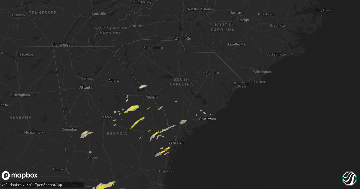
Hail Map in South Carolina on April 3, 2017
Get this storm
April 3 map
$229
one time, instant access
Download today. No call, no setup
Keep the $229
Bought the map and want the full workflow? Apply the entire $229 to a subscription within 7 days. None of it is wasted.
Every map, not just this one
This buys you this map. Subscription and you get every map we run, in the markets you choose from a few cities to whole states to nationwide. Plus real-time alerts the moment a storm fires.
Contact data
Name, contact info, occupancy, even credit band for addresses in the footprint. You go from where it hit to who to call.
Become the source they trust
Unlimited branding weather history reports on demand. You already have the documented answer ready for the property owner, and you are the one who showed up with it.
Property data and RoofTrace estimates
Pull up any address you have got, its value and the exact code rules for that jurisdiction, straight from One Click Code. Then RoofTrace estimates the squares, pitch, and roof value, priced the way you price.
Storm reports in South Carolina
South Carolina
| Date | Description |
|---|---|
| 04/03/20176:02 PM CDT | Schp reported a tree down at dairy ridge rd and croft state park rd |
| 04/03/20175:34 PM CDT | Tree reported down on sumter highway. Time based on radar. |
| 04/03/20175:16 PM CDT | The candb fire department reported several trees snapped or uprooted along farmington road near i-26. |
| 04/03/20175:12 PM CDT | A social media report of a tree down blocking boonehill road near tea farm road. |
| 04/03/20175:11 PM CDT | Several large trees blown down along portions of west meadow drive. Timed based on radar. |
| 04/03/20175:09 PM CDT | South carolina highway patrol reported a tree down on orangeburg road near the dorchester county department of social services building. |
| 04/03/20175:07 PM CDT | Highway patrol reported trees down across i-95 in the southbound lanes at mile marker 130. |
| 04/03/20175:07 PM CDT | South carolina highway patrol reported a tree down on whippoorwill drive near central avenue. |
| 04/03/20175:05 PM CDT | South carolina highway patrol reported a tree down on highway 17-a near highway 61. |
| 04/03/20175:00 PM CDT | Tree downed on i-95 at southbound exit 153 |
| 04/03/20175:00 PM CDT | South carolina highway patrol reported a tree down on highway17 between sandpit drive and clubhouse road. |
| 04/03/20174:55 PM CDT | Tree downed on raodway on stantons road |
| 04/03/20174:50 PM CDT | South carolina highway patrol reported a tree down on jacksonboro highway near round o road. |
| 04/03/20174:49 PM CDT | South carolina highway patrol reported a tree down on dodge lane near jacksonboro road. |
| 04/03/20174:42 PM CDT | South carolina highway patrol reported a tree down on charleston highway near bonnie doone road. |
| 04/03/20174:39 PM CDT | South carolina highway patrol reported a tree down in the 6000 block of green pond highway. |
| 04/03/20174:39 PM CDT | South carolina highway patrol reported a tree down in the 7500 block of green pond highway. |
| 04/03/20174:37 PM CDT | Tree in roadway |
| 04/03/20174:30 PM CDT | Trees in roadway |
| 04/03/20174:18 PM CDT | Deputy fire chief reports trees and power poles down along sikes... Rd and moorer rd near belleville... Rd. Two commercial structures in the area sustained major damage |
| 04/03/20174:18 PM CDT | Images from certified storm spotter shows multiple trees snapped or uprooted... Snapped and knocked over power poles and damage to a barn. Storm survey will be conducte |
| 04/03/20174:15 PM CDT | South carolina highway patrol reported a tree down on grays highway near the intersection with morgandollar road. |
| 04/03/20174:08 PM CDT | South carolina highway patrol reported a tree down on cayce road near willow swamp road. |
| 04/03/20174:06 PM CDT | South carolina highway patrol reported a tree down on calf pen bay road near pineland. |
| 04/03/20174:05 PM CDT | Trees down . |
| 04/03/20174:00 PM CDT | Richland county mesonet recorded a wind gust at williams brice stadium of 65 mph. . |
| 04/03/20173:58 PM CDT | South carolina highway patrol reported a tree down on gillison branch road near cypress branch road. |
| 04/03/20173:46 PM CDT | The hampton county warning point reported a tree down near hampton south carolina. |
| 04/03/20173:44 PM CDT | Multiple trees down on house and car near longs pond road. Images relayed via social media. |
| 04/03/20173:43 PM CDT | A nws storm survey team confired an ef0 tornado with winds near 80 mph touched down about 2.7 miles east of gifford then travelled about 0.28 miles to the east before l |
| 04/03/20173:43 PM CDT | Hampton county emergency manager reported around twenty trees down on thomas hamilton road. |
| 04/03/20173:43 PM CDT | Hampton fire and rescue reported trees down blocking the road in the 2600 block of hope well road. |
| 04/03/20173:42 PM CDT | The hampton county warning point reported a tree down thomas hamilton road. |
| 04/03/20173:38 PM CDT | The hampton county warning point reported a tree down on highway 363. |
| 04/03/20173:37 PM CDT | The hampton county warning point reported a tree down on highway 321. |
| 04/03/20173:33 PM CDT | Fence around properties blown over near juniper springs rd and tiger circle. Multiple trees snapped. Barn with cinder block walls blown out. Possible tornado... Storm s |
| 04/03/20173:32 PM CDT | Trees down near john everall road and john truesdale road. |
| 04/03/20173:30 PM CDT | Tree fell on house near pond branch rd south of gilbert... Sc. |
| 04/03/20173:30 PM CDT | Trees in roadway at old pardue road and zion road. Time estimated from radar. |
| 04/03/20173:14 PM CDT | A tornado touched down near old shoals road just south abney road where it snapped numerous pine trees. |
| 04/03/20173:13 PM CDT | Fire caused by downed power lines. . |
| 04/03/20173:08 PM CDT | Trees down on lee drive. |
| 04/03/20173:08 PM CDT | Trees in roadway near the intersection of hwy 39 and hwy 23. . |
| 04/03/20173:08 PM CDT | Several trees down in multiple directions along longwood drive indicates that a brief tornado occurred in the aiken estates subdivision. |
| 04/03/20173:05 PM CDT | Quarter size hail at two notch road and brandy road. . |
| 04/03/20173:05 PM CDT | Multiple trees down on homes on lynwood drive in aiken... Sc. Possible tornado. |
| 04/03/20172:51 PM CDT | Roof torn off of first citizens bank on church st. Time estimated from radar. |
| 04/03/20172:51 PM CDT | Numerous trees down in the town of chester. Time estimated from radar. |
| 04/03/20172:51 PM CDT | Metal roof peeled off of shop on beltline rd. Time estimated from radar. |
| 04/03/20172:49 PM CDT | Reported trees down in north augusta. |
| 04/03/20172:45 PM CDT | At least 2 trees down on calvary church road. |
| 04/03/20172:43 PM CDT | Few trees down scattered across the county. Time estimated from radar. |
| 04/03/20172:31 PM CDT | At least 2 trees down along beaty bridge road. Also a nearby fence blown down. |
| 04/03/20172:29 PM CDT | Brief touchdown with a few trees down with a convergent fall pattern. Tornado rated ef0 following storm survey. |
| 04/03/20172:25 PM CDT | Numerous trees down at the intersection of whitmire hwy and the tyger river. At least one tree fell on a car. Time estimated from radar. |
| 04/03/20172:23 PM CDT | *** 1 fatal *** mobile home flipped on eaves rd. Near the intersection of whitmire hwy and the tyger river. |
| 04/03/20172:05 PM CDT | Schp reported a tree down at old hills bridge rd and marshall tucker rd |
| 04/03/20172:04 PM CDT | Schp reported a tree down at dairy ridge rd and croft state park rd |
| 04/03/20171:53 PM CDT | Siding damage to building near campobello-gramling school. Time estimated from radar. |
| 04/03/20171:52 PM CDT | A few trees down and at least two trees leaning on a house on owens drive between the intersection with bramlett road and owens extension. |
| 04/03/20171:51 PM CDT | Tree down on mobile home at lakeview rd and owens dr just off hwy 14. Time estimated from radar. |
| 04/03/20171:51 PM CDT | Trees down in the town of central. Time estimated from radar. |
| 04/03/20171:43 PM CDT | About 30 trees down...some snapped...long farmer road. |
| 04/03/20171:42 PM CDT | Shingle and gutter damage to homes in the area of new cut rd and gowan rd. Time estimated from radar. |
| 04/03/20171:35 PM CDT | Trees down. Some large pecan and oak trees. Couple on houses on brockman road area. |
| 04/03/20171:33 PM CDT | Large tree down on car at woodruff rd and five forks rd. Time estimated from radar. |
| 04/03/20171:33 PM CDT | Tree down at berry rd and hwy 418. Time estimated from radar. |
| 04/03/20171:30 PM CDT | Trees down in 1100 block of pelham road. |
| 04/03/20171:25 PM CDT | Three trees down along with power lines down along tanyard road and cardinal drive. |
| 04/03/20171:25 PM CDT | Public reported trees snapped or uprooted on state park road. 14 trees some large... 1-2' diameter... 60-80' tall uprooted and/or snapped. Metal roof ripped off barn... |
| 04/03/20171:15 PM CDT | Trees down on cars and on a trailer along white horse rd. |
| 04/03/20171:07 PM CDT | Trees down in the town of starr. Time estimated from radar. |
| 04/03/201712:55 PM CDT | Around 10 trees down with one on a house. This house located on wood street and most of the rest of the trees down on marion street. |
| 04/03/201712:55 PM CDT | 6 large trees down just off fernway drive near the intersection with harvey road. |
| 04/03/201712:52 PM CDT | Trees and powerlines down on meredith st in central. Time estimated from radar. |
| 04/03/201712:51 PM CDT | Trees down in the town of central. Time estimated from radar. |
All States Impacted by Hail Map on April 3, 2017
Cities Impacted by Hail Map on April 3, 2017
- Buena Vista, GA
- Ellaville, GA
- Rupert, GA
- Mauk, GA
- Lucedale, MS
- Boston, GA
- Quitman, GA
- Dixie, GA
- Monticello, FL
- Valdosta, GA
- Perry, FL
- Arnett, OK
- Vici, OK
- Leedey, OK
- Camargo, OK
- Scott City, MO
- Thebes, IL
- Chaffee, MO
- McClure, IL
- Reydon, OK
- Midway, GA
- Fleming, GA
- Tamms, IL
- Ponte Vedra Beach, FL
- Sparta, GA
- Stratford, TX
- Mobile, AL
- Adrian, GA
- Kite, GA
- Canadian, TX
- Briscoe, TX
- Riceboro, GA
- Vidalia, GA
- Statesboro, GA
- Claxton, GA
- Register, GA
- Arapaho, OK
- Port Saint Joe, FL
- Wewahitchka, FL
- Eastpoint, FL
- Collins, GA
- Reidsville, GA
- Wilmer, AL
- Warthen, GA
- Semmes, AL
- Plum Branch, SC
- Lincolnton, GA
- Brooklet, GA
- Pembroke, GA
- Ellabell, GA
- Saint Augustine, FL
- Theodore, AL
- Grand Bay, AL
- Irvington, AL
- Moss Point, MS
- Bayou La Batre, AL
- Coden, AL
- Summerville, SC
- Jeffersonville, GA
- Ludowici, GA
- Mount Pleasant, SC
- Avera, GA
- Gibson, GA
- Davisboro, GA
- Louisville, GA
- Durham, OK
- Cheyenne, OK
- Girard, GA
- Tallahassee, FL
- Greenville, FL
- Thomasville, GA
- New Athens, IL
- Allenhurst, GA
- Hammon, OK
- Swainsboro, GA
- Wrightsville, GA
- East Dublin, GA
- Danville, GA
- Modoc, SC
- Stapleton, GA
- Sandersville, GA
- Mitchell, GA
- Midville, GA
- Yemassee, SC
- Early Branch, SC
- Hardin, KY
- Richmond Hill, GA
- Leesburg, GA
- Benton, KY
- Bamberg, SC
- Denmark, SC
- Preston, GA
- Oglethorpe, GA
- Ideal, GA
- Hazlehurst, GA
- Fort Stewart, GA
- Butler, OK
- Hinesville, GA
- Gruver, TX
- Springfield, GA
- Toomsboro, GA
- McIntyre, GA
- Braithwaite, LA
- Buras, LA
- Milledgeville, GA
- Ridgeville, SC
- Adams Run, SC
- Ladson, SC
- North Charleston, SC
- Goose Creek, SC
- Charleston, SC
- Hanahan, SC
- Vancleave, MS
- Martin, SC
- Haddock, GA
- Gordon, GA
- Pineland, SC
- Guyton, GA
- Garnett, SC
- Clyo, GA
- Tillman, SC
- Jesup, GA
- Johns Island, SC
- Cochran, GA
- Lamont, FL
- Perryton, TX
- Spearman, TX
- Crawfordville, GA
- Biloxi, MS
- Eight Mile, AL
- Rockledge, GA
- Wadley, GA
- Waynesboro, GA
- Keysville, GA
- Metter, GA
- Gilbertsville, KY
- Jacksonville, FL
- Green Cove Springs, FL


