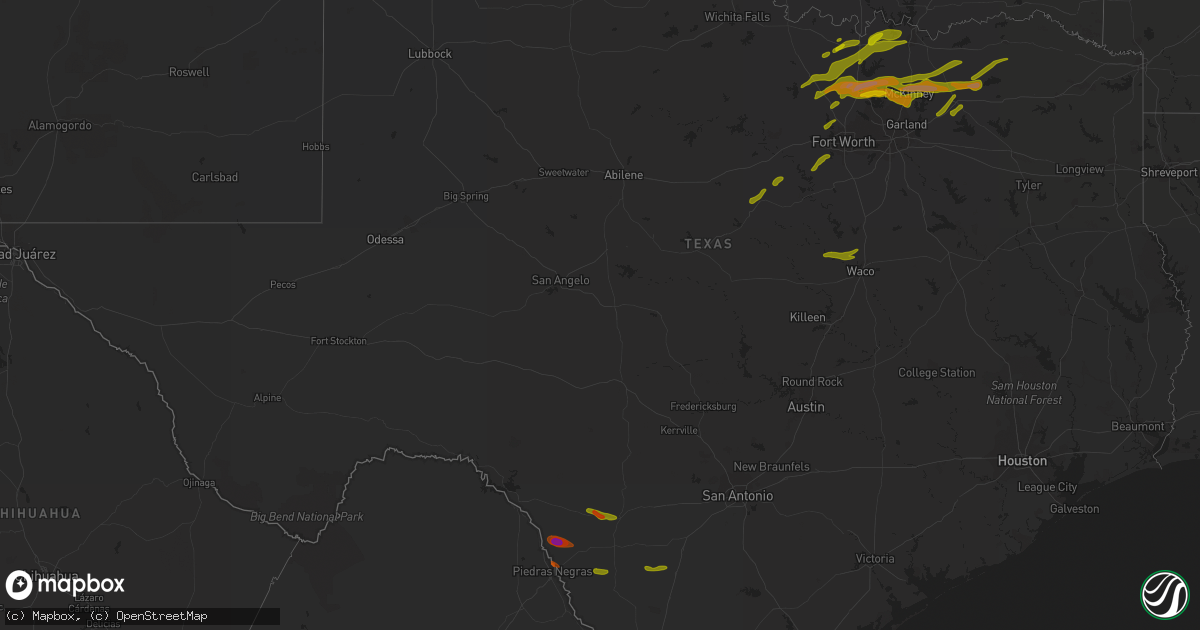
Hail Map in Texas on April 3, 2014
Get this storm
April 3 map
$229
one time, instant access
Download today. No call, no setup
Keep the $229
Bought the map and want the full workflow? Apply the entire $229 to a subscription within 7 days. None of it is wasted.
Every map, not just this one
This buys you this map. Subscription and you get every map we run, in the markets you choose from a few cities to whole states to nationwide. Plus real-time alerts the moment a storm fires.
Contact data
Name, contact info, occupancy, even credit band for addresses in the footprint. You go from where it hit to who to call.
Become the source they trust
Unlimited branding weather history reports on demand. You already have the documented answer ready for the property owner, and you are the one who showed up with it.
Property data and RoofTrace estimates
Pull up any address you have got, its value and the exact code rules for that jurisdiction, straight from One Click Code. Then RoofTrace estimates the squares, pitch, and roof value, priced the way you price.
Storm reports in Texas
Texas
| Date | Description |
|---|---|
| 04/03/20146:49 PM CDT | A local report indicates 1.50 inch wind near CELINA |
| 04/03/20146:48 PM CDT | A local report indicates 1.00 inch wind near PROSPER |
| 04/03/20146:45 PM CDT | A local report indicates 1.75 inch wind near 12 ENE ROCKSPRINGS |
| 04/03/20146:43 PM CDT | A local report indicates 1.00 inch wind near 5 SW BLUFF DALE |
| 04/03/20146:39 PM CDT | Quarter size hail 3 se of mustang |
| 04/03/20146:25 PM CDT | Golfball size hail reported |
| 04/03/20146:25 PM CDT | A local report indicates 1.00 inch wind near 16 NNE ROCKSPRINGS |
| 04/03/20146:24 PM CDT | Reports of up to baseball size hail just south of aubrey. Report relayed through fire dept. |
| 04/03/20146:21 PM CDT | Golfball size hail reported |
| 04/03/20146:16 PM CDT | Ping pong ball size hail reported just east of krum |
| 04/03/20146:12 PM CDT | Hen egg size hail |
| 04/03/20146:05 PM CDT | A local report indicates 60 MPH wind near DENTON |
| 04/03/20146:05 PM CDT | A local report indicates 1.00 inch wind near DENTON |
| 04/03/20146:04 PM CDT | Quarter size hail reported |
| 04/03/20146:04 PM CDT | A local report indicates 1.75 inch wind near DENTON |
| 04/03/20146:02 PM CDT | Kdto |
| 04/03/20146:00 PM CDT | Trees downed in krum |
| 04/03/20145:57 PM CDT | Reported just east of krum |
| 04/03/20145:49 PM CDT | Quarter size hail |
| 04/03/20145:30 PM CDT | New metal roof pelled back on outbuilding. Observer estimated wind speeds exceeding 60 mph. |
| 04/03/20145:20 PM CDT | Quarter size hail reported |
| 04/03/20145:10 PM CDT | Quarter size hail reported in stephenville |
| 04/03/20145:05 PM CDT | Quarter size hail 5 southwest of bluf dale |
| 04/03/20144:53 PM CDT | Quarter size hail in stephenville |
| 04/03/20144:53 PM CDT | Quarter size hail in anna |
| 04/03/20144:42 PM CDT | Softball size hail 1/8 mile west of twu campus in denton |
| 04/03/20143:51 PM CDT | Golfball size hail 4 north of denton |
| 04/03/20143:50 PM CDT | A local report indicates 1.75 inch wind near DENTON |
| 04/03/20143:48 PM CDT | Ping pong ball size hail at highway 288 2 north of denton |
| 04/03/20143:47 PM CDT | Golf ball to hen egg size hail 2 northeast of denton |
| 04/03/20143:46 PM CDT | 3.5 inch hail in denton |
| 04/03/20143:45 PM CDT | Baseball size hail |
| 04/03/20143:45 PM CDT | Ping pong to baseball size hail in denton |
| 04/03/20143:42 PM CDT | At 380 and i-35 |
| 04/03/20143:40 PM CDT | Golf ball size to hen egg size hail at interstate 35 and highway 288 |
| 04/03/20143:12 PM CDT | Ping pong ball size hail 9 southeast of decatur |
| 04/03/20142:56 PM CDT | Quarter size hail at highway 287 and cr 4421 |
| 04/03/20142:40 PM CDT | Quarter size hail 3 miles north of sanger |
| 04/03/20142:35 PM CDT | A local report indicates 1.00 inch wind near SANGER |
| 04/03/20142:22 PM CDT | Quarter size hail in slidell |
| 04/03/20141:59 PM CDT | Quarter size hail in central decatur |
| 04/03/20141:56 PM CDT | A local report indicates 1.25 inch wind near 2 S DECATUR |
| 04/03/201411:22 AM CDT | Nickel to quarter size hail near fm 2101 and 1570 |
| 04/03/20148:36 AM CDT | Era |
| 04/03/20148:18 AM CDT | Ping pong size hail in callisburg |
| 04/03/20147:24 AM CDT | Golfball hail 5 south of muenster |
| 04/03/20146:52 AM CDT | Spotter reported damage near the intersection of fm3073 and hwy 16. Travel trailers... Portable buildings... And trees were blown over. |
| 04/03/20146:00 AM CDT | Report from emergency manager of numerous trees and power lines down. |
| 04/03/20145:45 AM CDT | Report from emergency manager of trees snapped on wildwood golf course. |
| 04/03/20145:05 AM CDT | A local report indicates 1.00 inch wind near CALALLEN |
| 04/03/20145:05 AM CDT | A local report indicates 1.00 inch wind near ROBSTOWN |
| 04/03/20144:45 AM CDT | A section of the roof of a mobile home was blown off by high winds on sweet water road. |
| 04/03/20144:36 AM CDT | Golf ball sized hail through town of orange grove. The hail was wind driven and broke windows on some homes and damaged siding. Several trees knocked down. Also reports |
| 04/03/20144:35 AM CDT | A section of the roof of a mobile home was blown off by high winds on sweet water road. |
| 04/03/20144:27 AM CDT | Nws storm survey concluded that damaging straight line winds estimated at 65-70 mph impacted the town of orange grove. The damage path was 4.5 miles long and 3.2 miles |
| 04/03/20144:27 AM CDT | 25 feet by 30 feet shed anchored 3 feet into ground...totally ripped out and impalled into a fence and a roof of neighboring house |
| 04/03/20144:27 AM CDT | Golf ball sized hail through town of orange grove. The hail was wind driven and broke windows on some homes and damaged siding. Several trees knocked down. Also reports |
| 04/03/20144:22 AM CDT | Public report to sheriffs office of trees down on fm 1791. |
| 04/03/20141:10 AM CDT | Quarter and ping pong ball sized hail |
| 04/03/20141:10 AM CDT | Golfball hail report gathered via twitter. Time estimated via radar. |
| 04/03/201412:42 AM CDT | Numerous trees down...power lines down |
| 04/02/201411:55 PM CDT | Quarter to golfball size hail around the town of uvalde. Report gathered via twitter. |
| 04/02/201411:27 PM CDT | Media video depicted wind damage to trees... Powerlines... Roofs... And irrigation equipment in and near batesville. Time estimated from radar. |
| 04/02/201411:15 PM CDT | Golfball hail in elm creek. Time estimated via radar. Report gathered via twitter. |
| 04/02/201410:40 PM CDT | Trees down along fm1840 5 miles east of de kalb |
| 04/02/201410:34 PM CDT | A local report indicates 1.00 inch wind near DE KALB |
| 04/02/201410:05 PM CDT | Powerlines down along fm1001 5 miles north of mount pleasant |
| 04/02/20149:46 PM CDT | Barn moved off foundation and several trees down near white oak creek bottom |
| 04/02/20149:45 PM CDT | Tornado on the ground north of mount vernon along highway 37. |
| 04/02/20149:45 PM CDT | Numerous trees down |
| 04/02/20149:22 PM CDT | Brief tornado between cooper and cooper lake |
| 04/02/20149:20 PM CDT | Tornado 3 miles south of tira |
| 04/02/20149:20 PM CDT | Powerlines down along fm1001 5 miles north of mount pleasant |
| 04/02/20149:19 PM CDT | Possible tornado near tira/birthright. Intersection of hwy 19 and fm 71. Multiple homes and businesses damaged. Water tower blown over. Crews still investigating damage |
| 04/02/20149:14 PM CDT | Metal building damaged in tira |
| 04/02/20149:01 PM CDT | Golfball size hail in cooper |
| 04/02/20148:45 PM CDT | At texas a&m commerce campus. Fell for about 15 mintues |
| 04/02/20148:35 PM CDT | Ping pong to golfball size hail in the community of craig ranch |
| 04/02/20148:20 PM CDT | A local report indicates 1.50 inch wind near LUCAS |
| 04/02/20148:15 PM CDT | A local report indicates 1.00 inch wind near HIGHLAND VILLAGE |
| 04/02/20148:10 PM CDT | Trees snapped or uprooted. |
| 04/02/20148:09 PM CDT | Home significantly damaged on county road 1032 9 miles north of greenville |
| 04/02/20148:07 PM CDT | Home significantly damaged on county road 1081 15 miles northwest of greenville |
| 04/02/20148:07 PM CDT | Reported at legacy and jupiter |
| 04/02/20148:00 PM CDT | Half dollar hail reported in allen |
| 04/02/20148:00 PM CDT | Based on an nws damage survey...an ef1 tornado with a path length of approximately 1.8 miles occurred 3 miles east of merit. The time of occurrence is approximate. |
| 04/02/20148:00 PM CDT | Reported at hwy 380 and lake forest drive |
| 04/02/20147:50 PM CDT | Mcdermott and custer. |
| 04/02/20147:50 PM CDT | A local report indicates 2.00 inch wind near FRISCO |
| 04/02/20147:50 PM CDT | A local report indicates 68 MPH wind near FARMERSVILLE |
| 04/02/20147:50 PM CDT | Richmond drive in frisco |
| 04/02/20147:47 PM CDT | A local report indicates 1.75 inch wind near FRISCO |
| 04/02/20147:45 PM CDT | Golf ball hail damaged roof of home and took out two windows near legacy and sh121 |
| 04/02/20147:42 PM CDT | Fieldstone drive |
| 04/02/20147:40 PM CDT | Quarter hail reported in north fort worth off boat club road |
| 04/02/20147:40 PM CDT | A local report indicates 1.50 inch wind near FRISCO |
| 04/02/20147:38 PM CDT | 2.5 miles north of china springs |
| 04/02/20147:37 PM CDT | Quarter size hail in new hope |
| 04/02/20147:27 PM CDT | Hams reported that tornado crossed hwy 380 at north 6th street |
| 04/02/20147:22 PM CDT | A local report indicates 1.25 inch wind near 3 E DENTON |
| 04/02/20147:20 PM CDT | A local report indicates 1.00 inch wind near 4 S DENTON |
| 04/02/20147:16 PM CDT | Reported near tin top in southern parker county |
| 04/02/20147:15 PM CDT | Golfball size hail reported |
| 04/02/20147:15 PM CDT | Reported at sheriffs office at bloomdale road and us 75 |
All States Impacted by Hail Map on April 3, 2014
Cities Impacted by Hail Map on April 3, 2014
- Broken Arrow, OK
- Kansas, OK
- Rose, OK
- Peggs, OK
- Haskell, OK
- Bixby, OK
- Colcord, OK
- Porter, OK
- Twin Oaks, OK
- Coweta, OK
- Locust Grove, OK
- Wagoner, OK
- Chouteau, OK
- Mccurtain, OK
- Keota, OK
- Spiro, OK
- Checotah, OK
- Braggs, OK
- Cookson, OK
- Warner, OK
- Oktaha, OK
- Park Hill, OK
- Tahlequah, OK
- Welling, OK
- Council Hill, OK
- Muskogee, OK
- Bunch, OK
- Henryetta, OK
- Sallisaw, OK
- Gans, OK
- Muldrow, OK
- Roland, OK
- Van Buren, AR
- Stigler, OK
- Pryor, OK
- Inola, OK
- Taft, OK
- Boynton, OK
- Morris, OK
- Hulbert, OK
- Proctor, OK
- Okmulgee, OK
- Fort Gibson, OK
- Quapaw, OK
- Claremore, OK
- Westville, OK
- Summers, AR
- Siloam Springs, AR
- Fayetteville, AR
- McGee, MO
- Bell City, MO
- Williamsville, MO
- Benton, MO
- Wappapello, MO
- Zalma, MO
- Grandin, MO
- Doniphan, MO
- Harviell, MO
- Fairdealing, MO
- Bloomfield, MO
- Oran, MO
- Poplar Bluff, MO
- Scott City, MO
- Puxico, MO
- Chaffee, MO
- Thebes, IL
- Advance, MO
- Dowell, IL
- Elkville, IL
- Du Quoin, IL
- De Soto, IL
- Vergennes, IL
- Mulkeytown, IL
- Murphysboro, IL
- Grand Tower, IL
- Gorham, IL
- Jacob, IL
- Frohna, MO
- Altenburg, MO
- Newark, MO
- Novelty, MO
- New Franklin, MO
- Pilot Grove, MO
- Clark, MO
- Boonville, MO
- Moberly, MO
- Huntsville, MO
- Fayette, MO
- Franklin, MO
- Higbee, MO
- Richards, MO
- Moundville, MO
- Nevada, MO
- El Dorado Springs, MO
- Rockville, MO
- Edwards, MO
- Deepwater, MO
- Lincoln, MO
- Lowry City, MO
- Osceola, MO
- Clinton, MO
- Quincy, MO
- Stover, MO
- Warsaw, MO
- Gravois Mills, MO
- Schell City, MO
- Butler, MO
- Montrose, MO
- Excello, MO
- Blackwater, MO
- Armstrong, MO
- Marshall, MO
- Callao, MO
- Hughesville, MO
- Anabel, MO
- Salisbury, MO
- Clifton Hill, MO
- Macon, MO
- Sedalia, MO
- Nelson, MO
- Gilliam, MO
- Keytesville, MO
- Glasgow, MO
- La Monte, MO
- Slater, MO
- Houstonia, MO
- Bevier, MO
- Jasper, MO
- Oronogo, MO
- Columbus, KS
- Galena, KS
- Asbury, MO
- Weir, KS
- Pittsburg, KS
- Ava, MO
- Long Lane, MO
- Buffalo, MO
- Highlandville, MO
- Galena, MO
- Aurora, MO
- Ozark, MO
- Spokane, MO
- Ponce De Leon, MO
- Bolivar, MO
- Polk, MO
- Kissee Mills, MO
- Seymour, MO
- Oldfield, MO
- Lebanon, MO
- Eldridge, MO
- Windyville, MO
- Caneyville, KY
- Horse Branch, KY
- Morgantown, KY
- Leitchfield, KY
- Millwood, KY
- Henley, MO
- Saint Elizabeth, MO
- Westphalia, MO
- Meta, MO
- Jefferson City, MO
- Eldon, MO
- Tuscumbia, MO
- Eugene, MO
- Saint Thomas, MO
- Lake Ozark, MO
- Ballwin, MO
- Saint Louis, MO
- Brinktown, MO
- Vienna, MO
- Dixon, MO
- Iberia, MO
- Gray Summit, MO
- Union, MO
- Valley Park, MO
- Beaufort, MO
- Pacific, MO
- Eureka, MO
- Wildwood, MO
- Washington, MO
- Labadie, MO
- Villa Ridge, MO
- Saint James, MO
- Rolla, MO
- Leasburg, MO
- Cuba, MO
- Sullivan, MO
- Bourbon, MO
- Richwoods, MO
- Eagle Pass, TX
- Dilley, TX
- Crystal City, TX
- Uvalde, TX
- Quemado, TX
- Era, TX
- Sherman, TX
- Sadler, TX
- Sanger, TX
- Whitesboro, TX
- Pottsboro, TX
- Alvord, TX
- Rosston, TX
- Chico, TX
- Collinsville, TX
- Bridgeport, TX
- Valley View, TX
- Gainesville, TX
- Decatur, TX
- Muenster, TX
- Saint Jo, TX
- Forestburg, TX
- Greenville, TX
- Royse City, TX
- Caddo Mills, TX
- Lindsay, TX
- Bluff Dale, TX
- Tolar, TX
- Krum, TX
- Ponder, TX
- Aubrey, TX
- Pilot Point, TX
- Denton, TX
- Celina, TX
- Paris, TX
- Klondike, TX
- Ladonia, TX
- Roxton, TX
- Pecan Gap, TX
- Commerce, TX
- Cooper, TX
- Stephenville, TX
- Dublin, TX
- Melissa, TX
- Blue Ridge, TX
- Princeton, TX
- Celeste, TX
- Mckinney, TX
- Farmersville, TX
- Prosper, TX
- Little Elm, TX
- Argyle, TX
- Allen, TX
- Plano, TX
- Frisco, TX
- Wolfe City, TX
- Haslet, TX
- Fort Worth, TX
- Azle, TX
- Justin, TX
- Rhome, TX
- China Spring, TX
- Waco, TX
- Valley Mills, TX
- West, TX
- Cresson, TX
- Godley, TX
- Granbury, TX
- Weatherford, TX
- Trenton, TX
- Anna, TX
- Bonham, TX
- Leonard, TX
- Bailey, TX
- Windom, TX
- Mammoth Spring, AR
- Pineville, AR
- Oxford, AR
- Dolph, AR
- Hardy, AR
- Salem, AR
- Brockwell, AR
- Glencoe, AR
- Marshall, AR
- Wideman, AR
- Big Flat, AR
- Calico Rock, AR
- Leslie, AR
- Ash Flat, AR
- Harriet, AR
- Somerville, TN
- Moscow, TN
- Knob Noster, MO
- Marthasville, MO
- Foristell, MO
- Augusta, MO
- Defiance, MO
- Leslie, MO
- Saint Charles, MO
- Fenton, MO
- Chesterfield, MO
- Saint Albans, MO
- Humansville, MO
- Stockton, MO
- Flemington, MO
- Fair Play, MO
- Dunnegan, MO
- Dadeville, MO
- Weaubleau, MO
- Wheatland, MO
- Arcola, MO
- Greenfield, MO
- Rocky Mount, MO
- Loose Creek, MO
- Kaiser, MO
- Osage Beach, MO
- Linn, MO
- Sunrise Beach, MO
- Bonnots Mill, MO
- Jonesboro, IL
- Alto Pass, IL
- Cobden, IL
- Wolf Lake, IL
- Anna, IL
- Versailles, MO
- Cedar Hill, MO
- Catawissa, MO
- House Springs, MO
- Bardstown, KY
- Springfield, KY
- Crane, MO
- Watts, OK
- Watson, AR
- Weleetka, OK
- Eufaula, OK
- Vian, OK
- Coffeeville, MS
- Pearsall, TX
- Houston, MS
- Okolona, MS
- Grand Saline, TX
- Canton, TX
- Urbana, MO
- Salina, OK
- Cromwell, KY
- Clarkson, KY
- Chadwick, MO
- Wyandotte, OK
- Carlton, TX
- Hico, TX
- Goldthwaite, TX
- Mullin, TX
- Willow City, TX
- Llano, TX
- Fredericksburg, TX
- Round Mountain, TX
- Waynesville, MO
- Laquey, MO
- Richland, MO
- Hermitage, MO
- Preston, MO
- Cross Timbers, MO
- Macks Creek, MO
- Sturdivant, MO
- Quinlan, TX
- Richardson, TX
- Smithton, MO
- Fruitvale, TX
- Edgewood, TX
- Alba, TX
- Boston, KY
- New Haven, KY
- Ullin, IL
- Tamms, IL
- Garfield, AR
- Pea Ridge, AR
- Bella Vista, AR
- Bentonville, AR
- Seligman, MO
- De Kalb, TX
- New Boston, TX
- Rocksprings, TX
- Omaha, IL
- Ridgway, IL
- De Leon, TX
- Realitos, TX
- Hebbronville, TX
- Laredo, TX
- Walker, MO
- Cole Camp, MO
- Wiseman, AR
- Rich Hill, MO
- Appleton City, MO
- Morrison, MO
- Chamois, MO
- Hermann, MO
- Mount Sterling, MO
- Duke, MO
- Devils Elbow, MO
- Fort Leonard Wood, MO
- Saint Robert, MO
- Newburg, MO
- The Colony, TX
- Couch, MO
- Violet Hill, AR
- Ravenden, AR
- Pocahontas, AR
- Brownwood, MO
- Camp, AR
- Gatewood, MO
- Myrtle, MO
- Horseshoe Bend, AR
- Fisk, MO
- Onia, AR
- Adair, OK
- Quitman, TX
- Mineola, TX
- Talco, TX
- Bogata, TX
- Winnfield, LA
- Winslow, AR
- Elkins, AR
- Wilburton, OK
- Ozona, TX
- La Pryor, TX
- Zephyr, TX
- Early, TX
- Climax Springs, MO
- Harwood, MO
- Roach, MO
- Louisburg, MO
- Marquand, MO
- Denison, TX
- Bells, TX
- Beggs, OK
- Wiergate, TX
- Brookeland, TX
- Bronson, TX
- Broaddus, TX
- Mason, TX
- Doss, TX
- Big Wells, TX
- Asherton, TX
- Cotulla, TX
- Oak Ridge, MO
- Evant, TX
- Hamilton, TX
- Aledo, TX
- Green Ridge, MO
- Ionia, MO
- Windsor, MO
- Stringtown, OK
- Atoka, OK
- Calliham, TX
- Tilden, TX
- Comanche, TX
- Orange Grove, TX
- Leonard, MO
- Urich, MO
- Arnold, MO
- Imperial, MO
- Eucha, OK
- Bristow, IN
- Saint Meinrad, IN
- Coldwater, MS
- Hernando, MS
- Sarah, MS
- Senatobia, MS
- Simms, TX
- Avery, TX
- Huntsville, AR
- Wesley, AR
- Como, TX
- Yantis, TX
- Emory, TX
- Pickton, TX
- Winnsboro, TX
- Gustine, TX
- Van, TX
- Robeline, LA
- Leakey, TX
- Milltown, IN
- Marengo, IN
- Berryville, AR
- Elizabethtown, KY
- Snow, OK
- Nashoba, OK
- Savoy, TX
- Whitewright, TX
- Pleasanton, TX
- Jourdanton, TX
- Mountain Home, TX
- Junction, TX
- Harper, TX
- Bruni, TX
- Mirando City, TX
- Comfort, TX
- Waldo, AR
- Batesville, TX
- George West, TX
- Florence, MO
- Fortuna, MO
- Robstown, TX
- Lonedell, MO
- Tunas, MO
- Greenville, MO
- Sulphur Springs, AR
- Gravette, AR
- Rogers, AR
- Mounds, OK
- Tupelo, MS
- Flower Mound, TX
- Lake Dallas, TX
- Lewisville, TX
- Moore, TX
- Bigfoot, TX
- Campbellton, TX
- Jacksonville, MO
- Marble Hill, MO
- Jackson, MO
- Leopold, MO
- Cape Girardeau, MO
- Whitewater, MO
- Burfordville, MO
- Olive Branch, IL
- Pulaski, IL
- Garland, TX
- Sachse, TX
- Gillett, AR
- Syracuse, MO
- Oak Grove, LA
- Marthaville, LA
- Sandia, TX
- English, IN
- Half Way, MO
- Hartford, KY
- Fordsville, KY
- Theodosia, MO
- Thornfield, MO
- Wasola, MO
- Noble, MO
- Squires, MO
- Clayton, OK
- Jasper, AR
- Florien, LA
- Many, LA
- Terrell, TX
- Anderson, TX
- Mora, MO
- Rosebud, MO
- Owensville, MO
- Seneca, MO
- Otterville, MO
- Eldorado, IL
- Dry Prong, LA
- Bentley, LA
- Paradise, TX
- Lipan, TX
- Campbell, TX
- Natchitoches, LA
- Natchez, LA
- Oilton, TX
- Madison, MO
- Lockwood, MO
- Forney, TX
- Hattieville, AR
- Pollock, LA
- Montgomery City, MO
- Chetopa, KS
- Dike, TX
- Sulphur Springs, TX
- Van Alstyne, TX
- Centerville, TX
- Saline, LA
- Jonesboro, LA
- Lone Oak, TX
- Olean, MO
- Russellville, MO
- Bunceton, MO
- Bland, MO
- Gerald, MO
- Belle, MO
- Columbia, MO
- Fort Scott, KS
- Deerfield, MO
- Olaton, KY
- Falls Of Rough, KY
- Bronaugh, MO
- Willisburg, KY
- Carl Junction, MO
- Hartshorne, OK
- Neosho, MO
- Pontotoc, MS
- Bokchito, OK
- Blossom, TX
- Stuttgart, AR
- De Witt, AR
- Sunnyvale, TX
- Rockwall, TX
- Mesquite, TX
- Wylie, TX
- Corpus Christi, TX
- Emden, MO
- Shelbina, MO
- Hunnewell, MO
- Brackettville, TX
- Pittsburg, MO
- Camdenton, MO
- Loretto, KY
- Fulton, MS
- Hawesville, KY
- Eureka Springs, AR
- Cecilia, KY
- Eastview, KY
- Pineville, MO
- Centerton, AR
- Boyd, TX
- Ben Franklin, TX
- Cumby, TX
- Hendrix, OK
- Wills Point, TX
- Buffalo, TX
- Purmela, TX
- Jonesboro, TX
- Stamps, AR
- Lewisville, AR
- Glen Rose, TX
- Pineland, TX
- Ingram, TX
- Kerrville, TX
- Calhoun, MO
- Waterloo, IL
- New Haven, IL
- Equality, IL
- Millersville, MO
- Van Buren, MO
- Redbird, OK
- Cedarville, AR
- Buckner, AR
- Annona, TX
- Cookville, TX
- Omaha, TX
- Roanoke, TX
- Hemphill, TX
- Williamstown, KY
- Corinth, KY
- Berry, KY
- Falmouth, KY
- Holliday, MO
- Rocheport, MO
- Vichy, MO
- Lewisport, KY
- Uniontown, MO
- Irvine, KY
- Clay City, KY
- Ravenna, KY
- Hodgenville, KY
- Patton, MO
- Sparta, MO
- Springfield, MO
- Nixa, MO
- Bradley, AR
- Dallas, TX
- Point, TX
- Pittsboro, MS
- Lincoln, AR
- Clarence, MO
- Robertsville, MO
- Wentzville, MO
- O'Fallon, MO
- Fulton, MO
- Mokane, MO
- Steedman, MO
- Boonville, IN
- Campbell Hill, IL
- Rockwood, IL
- Hudson, KY
- McDaniels, KY
- Dundee, KY
- Big Clifty, KY
- Phillipsburg, MO
- Vienna, IL
- Cypress, IL
- Fair Grove, MO
- Walnut Shade, MO
- Chestnutridge, MO
- Spavinaw, OK
- Catoosa, OK
- Porum, OK
- Kingston, OK
- Hodgen, OK
- Heavener, OK
- Byhalia, MS
- Collierville, TN
- Nettleton, MS
- Plantersville, MS
- Coahoma, MS
- Dundee, MS
- Shannon, MS
- Vardaman, MS
- Calhoun City, MS
- Derma, MS
- Texarkana, AR
- Hugo, OK
- Camden, AR
- Tillar, AR
- Coppell, TX
- Cleburne, TX
- Oelwein, IA
- Hartsburg, MO
- Ashland, MO
- Foster, MO
- Ferdinand, IN
- Hillsboro, MO
- Dittmer, MO
- Liberal, MO
- Mill Spring, MO
- Silva, MO
- Huron, TN
- Luray, TN
- Beech Bluff, TN
- Henderson, TN
- Kinta, OK
- Red Oak, OK
- Bradleyville, MO
- Chelsea, OK
- Eads, TN
- Tunica, MS
- Big Creek, MS
- Crenshaw, MS
- Summerfield, LA
- Haynesville, LA
- Lillie, LA
- Mount Pleasant, TX
- North Richland Hills, TX
- Keller, TX
- Kaufman, TX
- Quitman, LA
- Olla, LA
- Tullos, LA
- Columbia, LA
- Goldonna, LA
- Bedias, TX
- Yancey, TX
- Columbia, IL
- Valmeyer, IL
- Junction, IL
- Shawneetown, IL
- Stoutland, MO
- Steelville, MO
- Conway, MO
- Niangua, MO
- McCune, KS
- Cherokee, KS
- Clever, MO
- Billings, MO
- Reeds Spring, MO
- Washburn, MO
- Powell, MO
- Canehill, AR
- Whiteville, TN
- Hampton, AR
- Harrell, AR
- Houlka, MS
- Garland City, AR
- Fouke, AR
- Doddridge, AR
- Nevada, TX
- Crowley, TX
- Sikes, LA
- Montgomery, LA
- Deville, LA
- Pineville, LA
- Clifton, TX
- Gatesville, TX
- Charlotte, TX
- Benton, IL
- Sesser, IL
- Clarksburg, MO
- Sturgeon, MO
- Harrisburg, MO
- Kingdom City, MO
- Williamsburg, MO
- Stanton, KY
- Sturgis, KY
- Morganfield, KY
- Sonora, KY
- White Mills, KY
- Beaver Dam, KY
- Mindenmines, MO
- Brookline, MO
- Republic, MO
- Marshfield, MO
- Elkland, MO
- Green Forest, AR
- Oak Grove, AR
- Oakland, TN
- Williston, TN
- Rossville, TN
- Louann, AR
- Charleston, AR
- Brashear, TX
- Haltom City, TX
- Naval Air Station Jrb, TX
- Gladewater, TX
- Kilgore, TX
- Zavalla, TX
- Bryan, TX
- San Diego, TX
- Cairo, MO
- Tipton, MO
- Barnett, MO
- Arcadia, KS
- Depauw, IN
- Ramsey, IN
- Grantsburg, IN
- Ava, IL
- Santa Claus, IN
- Lamar, IN
- Cannelton, IN
- Lamar, MO
- Jerico Springs, MO
- Golden City, MO
- Mount Vernon, IN
- Uniontown, KY
- Mount Pleasant, AR
- Sidney, AR
- Alton, MO
- Fremont, MO
- Hindsville, AR
- Alma, AR
- Webbers Falls, OK
- Bolivar, TN
- Hickory Valley, TN
- Coalgate, OK
- Pittsburg, OK
- Bennington, OK
- Gordonville, TX
- Calera, OK
- Pattonville, TX
- Colbert, OK
- Honey Grove, TX
- Howe, TX
- Sulphur Bluff, TX
- Deport, TX
- Lake Creek, TX
- Cartwright, OK
- Texarkana, TX
- Mineral Springs, AR
- Gunter, TX
- Detroit, TX
- Dodson, LA
- Gilmer, TX
- Del Rio, TX
- Comstock, TX
- High Ridge, MO
- Barnhart, MO
- Crocker, MO
- Waltonville, IL
- Newburgh, IN
- Lawson, MO
- Fairland, OK
- Goreville, IL
- Marion, IL
- Prairie Grove, AR
- Jefferson, TX
- Sheldon, MO
- Ethel, AR
- Banner, MS
- Booneville, AR
- Jay, OK
- Ravenna, TX
- Mer Rouge, LA
- Leesville, LA
- Pitkin, LA
- Deridder, LA
- Bethel, MO
- Brumley, MO
- Hardinsburg, KY
- Cave In Rock, IL
- Crab Orchard, KY
- Lodi, MO
- Clubb, MO
- Raymondville, MO
- Gipsy, MO
- Cherokee Village, AR
- Mount Judea, AR
- Witts Springs, AR
- Lowndes, MO
- McClure, IL
- Ridgedale, MO
- Hollister, MO
- Kirbyville, MO
- Cedarcreek, MO
- Omaha, AR
- Shell Knob, MO
- Big Cabin, OK
- Atkins, AR
- Morrilton, AR
- Solgohachia, AR
- Stonewall, OK
- Grady, AR
- Altheimer, AR
- Rattan, OK
- Cleveland, MS
- Merigold, MS
- Ivanhoe, TX
- Telephone, TX
- Madill, OK
- Stephens, AR
- Eupora, MS
- Tioga, TX
- Georgetown, LA
- Mathis, TX
- Rudy, AR
- Uniontown, AR
- Norfork, AR
- Grovespring, MO
- Melbourne, AR
- Mountain View, AR
- Saint Clair, MO
- Rumsey, KY
- Harrisburg, IL
- Raleigh, IL
- Buncombe, IL
- Makanda, IL
- Edgar Springs, MO
- Evanston, IN
- Tell City, IN
- Bluejacket, OK
- Miami, OK
- Welch, OK
- Pinson, TN
- Medon, TN
- Toone, TN
- Marvell, AR
- Holly Grove, AR
- Almyra, AR
- Grapevine, TX
- Colfax, LA
- Longview, TX
- College Station, TX
- Holts Summit, MO
- New Bloomfield, MO
- Tebbetts, MO
- Ulman, MO
- Milo, MO
- Rogersville, MO
- Vinita, OK
- Witter, AR
- Kingston, AR
- Gore, OK
- Dustin, OK
- West Fork, AR
- Natural Dam, AR
- Chester, AR
- Petty, TX
- Rosston, AR
- Maud, TX
- Hooks, TX
- Bastrop, LA
- Rayville, LA
- Brownwood, TX
- Pottsville, TX
- Priddy, TX
- Iola, TX
- Coulterville, IL
- Rhineland, MO
- Linn Creek, MO
- Portland, MO
- Stamping Ground, KY
- Owenton, KY
- Sadieville, KY
- Falcon, MO
- Jerome, MO
- Winona, MO
- Hiwasse, AR
- Decatur, AR
- Eagle Rock, MO
- Cassville, MO
- Parthenon, AR
- Powderly, TX
- Arthur City, TX
- Grant, OK
- Star City, AR
- Yorktown, AR
- Bernice, LA
- Holcomb, MS
- Grenada, MS
- Pittsburg, TX
- Leesburg, TX
- Bearden, AR
- Lindale, TX
- Provencal, LA
- Melrose, LA
- Cloutierville, LA
- Belmont, LA
- Campti, LA
- Chatham, LA
- Jewett, TX


