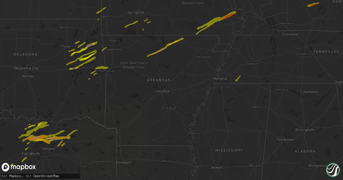
Hail Map in Arkansas on April 3, 2014
Get this storm
April 3 map
$229
one time, instant access
Download today. No call, no setup
Keep the $229
Bought the map and want the full workflow? Apply the entire $229 to a subscription within 7 days. None of it is wasted.
Every map, not just this one
This buys you this map. Subscription and you get every map we run, in the markets you choose from a few cities to whole states to nationwide. Plus real-time alerts the moment a storm fires.
Contact data
Name, contact info, occupancy, even credit band for addresses in the footprint. You go from where it hit to who to call.
Become the source they trust
Unlimited branding weather history reports on demand. You already have the documented answer ready for the property owner, and you are the one who showed up with it.
Property data and RoofTrace estimates
Pull up any address you have got, its value and the exact code rules for that jurisdiction, straight from One Click Code. Then RoofTrace estimates the squares, pitch, and roof value, priced the way you price.
Storm reports in Arkansas
Arkansas
| Date | Description |
|---|---|
| 04/03/20146:38 PM CDT | Social media report relayed by broadcast media with picture. |
| 04/03/20145:56 PM CDT | Damage to vehicles. |
| 04/03/20145:48 PM CDT | Northwest side of pea ridge |
| 04/03/20145:40 PM CDT | Report of 50 to 60 mph winds and pea size hail. |
| 04/03/20142:25 PM CDT | A local report indicates 1.00 inch wind near OZAN |
| 04/03/20149:45 AM CDT | Phone lines were reported down in cauthron. |
| 04/03/20142:55 AM CDT | Power lines down |
| 04/03/20142:00 AM CDT | Tree down on stevens rd |
| 04/03/20141:46 AM CDT | Trees and power lines downed along rose hill road |
| 04/03/20141:20 AM CDT | Lots of trees and powerlines are down across the county. |
| 04/03/20141:00 AM CDT | Many trees down in warren and around the county. |
| 04/03/20141:00 AM CDT | Trees and power lines down due to strong thunderstorm winds. |
| 04/03/201412:55 AM CDT | Trees blown down as severe thunderstorm moved through the area. |
| 04/03/201412:50 AM CDT | One chicken house collapsed and two more were damaged. Many hundreds of chickens were killed. Mumerous trees and power lines were blown donw. Houses and out buildings w |
| 04/03/201412:45 AM CDT | Numerous trees were blown down in an area from 3 ene to 5 ene of harrell. |
| 04/03/201412:45 AM CDT | Numerous trees down along highway 167 between fordyce and hampton. Traffic cant get through in many places. |
| 04/03/201412:45 AM CDT | Trees blown down as severe thunderstorm moved through the area. |
| 04/03/201412:40 AM CDT | Many trees and powerlines were downed around hampton. |
| 04/03/201412:40 AM CDT | Trees down on bunn mcgriff road at highway 167. |
| 04/03/201412:30 AM CDT | Spotters report numerous trees down from near carthage to a few miles north of carthage. A few vehicles were moved off highway 167 into the ditch. |
| 04/03/201412:30 AM CDT | Winds are estimated at 85 mph. Numerous trees and power lines down. Some houses were damaged when trees fell on them. Camden fairview high school had damage to the athl |
| 04/03/201412:29 AM CDT | Numerous trees were blown down from a bow echo. Several houses had roof damage and part of a roof was taken off a metal building. A house had its winds knocked out by a |
| 04/03/201412:28 AM CDT | A local report indicates 58 MPH wind near 9 W EL DORADO |
| 04/03/201412:27 AM CDT | Numerous trees were blown down. |
| 04/03/201412:25 AM CDT | Many trees are down. |
| 04/03/201412:22 AM CDT | Trees were blown down from a bow echo. A house had roof damage. Winds were estimated at 80 mph. |
| 04/03/201412:17 AM CDT | Trees down from a bow echo. A tree fell and crushed a vacant house. A couple of mobile homes had roof damage near manning. Winds were estimated at 80 mph. |
| 04/03/201412:15 AM CDT | Winds are estimated at 85 mph. Numerous trees and power lines down. Some houses were damaged when trees fell on them. Camden fairview high school had damage to the athl |
| 04/03/201412:12 AM CDT | Numerous trees down from a bow echo. Winds were estimated at 80 mph. |
| 04/03/201412:10 AM CDT | Tops of trees were broke off and large tree uprooted on helms road near highway 26. |
| 04/03/201412:10 AM CDT | Numerous trees down |
| 04/02/201411:56 PM CDT | State police estimated wind gust to 70 mph...numerous trees down...power lines down...quarter sized hail and heavy rain |
| 04/02/201411:50 PM CDT | All power out in the town |
| 04/02/201411:45 PM CDT | Tree reported down on a car. |
| 04/02/201411:45 PM CDT | Tree reported down on highway 270 west. |
| 04/02/201411:45 PM CDT | Several trees downed throughout the county including trees across 2 homes in prescott. |
| 04/02/201411:40 PM CDT | Numerous trees and powerlines down across the county |
| 04/02/201411:35 PM CDT | A local report indicates 1.00 inch wind near LEWISVILLE |
| 04/02/201411:35 PM CDT | Numerous trees down |
| 04/02/201411:35 PM CDT | Small limbs down |
| 04/02/201411:30 PM CDT | Trees and powerlines down across the county due to thunderstorms. |
| 04/02/201411:30 PM CDT | Six homes damaged and mulitple trees down in perrytown and trees down coutywide. |
| 04/02/201411:20 PM CDT | Numerous trees reported down on highway 70 east as well as powerlines down in the area. |
| 04/02/201411:10 PM CDT | Two homes sustained damage. Also a shed was completely blown away along with numerous trees down. |
| 04/02/201411:00 PM CDT | Trees down |
| 04/02/201410:53 PM CDT | Trees down across wilson rd |
| 04/02/201410:50 PM CDT | Numerous trees down accross the county |
| 04/02/201410:50 PM CDT | Large tree limbs down |
| 04/02/20149:23 PM CDT | Social media report relayed by media with picture |
| 04/02/20148:54 PM CDT | Nickel to quarter size hail was reported just east of agnos. |
| 04/02/20148:50 PM CDT | A local report indicates 1.75 inch wind near GLENCOE |
| 04/02/20148:35 PM CDT | A local report indicates 1.75 inch wind near CALICO ROCK |
| 04/02/20148:30 PM CDT | Spotty tree damage located around town as a result of isolated thunderstorm wind damage. |
| 04/02/20148:30 PM CDT | A local report indicates 2.50 inch wind near 3 N WIDEMAN |
| 04/02/20148:15 PM CDT | Hail was almost to the size of tennis balls at big flat. |
| 04/02/20148:00 PM CDT | A local report indicates 3.00 inch wind near MARSHALL |
| 04/02/20148:00 PM CDT | Quarter sized hail in marshall. |
All States Impacted by Hail Map on April 3, 2014
Cities Impacted by Hail Map on April 3, 2014
- Broken Arrow, OK
- Kansas, OK
- Rose, OK
- Peggs, OK
- Haskell, OK
- Bixby, OK
- Colcord, OK
- Porter, OK
- Twin Oaks, OK
- Coweta, OK
- Locust Grove, OK
- Wagoner, OK
- Chouteau, OK
- Mccurtain, OK
- Keota, OK
- Spiro, OK
- Checotah, OK
- Braggs, OK
- Cookson, OK
- Warner, OK
- Oktaha, OK
- Park Hill, OK
- Tahlequah, OK
- Welling, OK
- Council Hill, OK
- Muskogee, OK
- Bunch, OK
- Henryetta, OK
- Sallisaw, OK
- Gans, OK
- Muldrow, OK
- Roland, OK
- Van Buren, AR
- Stigler, OK
- Pryor, OK
- Inola, OK
- Taft, OK
- Boynton, OK
- Morris, OK
- Hulbert, OK
- Proctor, OK
- Okmulgee, OK
- Fort Gibson, OK
- Quapaw, OK
- Claremore, OK
- Westville, OK
- Summers, AR
- Siloam Springs, AR
- Fayetteville, AR
- McGee, MO
- Bell City, MO
- Williamsville, MO
- Benton, MO
- Wappapello, MO
- Zalma, MO
- Grandin, MO
- Doniphan, MO
- Harviell, MO
- Fairdealing, MO
- Bloomfield, MO
- Oran, MO
- Poplar Bluff, MO
- Scott City, MO
- Puxico, MO
- Chaffee, MO
- Thebes, IL
- Advance, MO
- Dowell, IL
- Elkville, IL
- Du Quoin, IL
- De Soto, IL
- Vergennes, IL
- Mulkeytown, IL
- Murphysboro, IL
- Grand Tower, IL
- Gorham, IL
- Jacob, IL
- Frohna, MO
- Altenburg, MO
- Newark, MO
- Novelty, MO
- New Franklin, MO
- Pilot Grove, MO
- Clark, MO
- Boonville, MO
- Moberly, MO
- Huntsville, MO
- Fayette, MO
- Franklin, MO
- Higbee, MO
- Richards, MO
- Moundville, MO
- Nevada, MO
- El Dorado Springs, MO
- Rockville, MO
- Edwards, MO
- Deepwater, MO
- Lincoln, MO
- Lowry City, MO
- Osceola, MO
- Clinton, MO
- Quincy, MO
- Stover, MO
- Warsaw, MO
- Gravois Mills, MO
- Schell City, MO
- Butler, MO
- Montrose, MO
- Excello, MO
- Blackwater, MO
- Armstrong, MO
- Marshall, MO
- Callao, MO
- Hughesville, MO
- Anabel, MO
- Salisbury, MO
- Clifton Hill, MO
- Macon, MO
- Sedalia, MO
- Nelson, MO
- Gilliam, MO
- Keytesville, MO
- Glasgow, MO
- La Monte, MO
- Slater, MO
- Houstonia, MO
- Bevier, MO
- Jasper, MO
- Oronogo, MO
- Columbus, KS
- Galena, KS
- Asbury, MO
- Weir, KS
- Pittsburg, KS
- Ava, MO
- Long Lane, MO
- Buffalo, MO
- Highlandville, MO
- Galena, MO
- Aurora, MO
- Ozark, MO
- Spokane, MO
- Ponce De Leon, MO
- Bolivar, MO
- Polk, MO
- Kissee Mills, MO
- Seymour, MO
- Oldfield, MO
- Lebanon, MO
- Eldridge, MO
- Windyville, MO
- Caneyville, KY
- Horse Branch, KY
- Morgantown, KY
- Leitchfield, KY
- Millwood, KY
- Henley, MO
- Saint Elizabeth, MO
- Westphalia, MO
- Meta, MO
- Jefferson City, MO
- Eldon, MO
- Tuscumbia, MO
- Eugene, MO
- Saint Thomas, MO
- Lake Ozark, MO
- Ballwin, MO
- Saint Louis, MO
- Brinktown, MO
- Vienna, MO
- Dixon, MO
- Iberia, MO
- Gray Summit, MO
- Union, MO
- Valley Park, MO
- Beaufort, MO
- Pacific, MO
- Eureka, MO
- Wildwood, MO
- Washington, MO
- Labadie, MO
- Villa Ridge, MO
- Saint James, MO
- Rolla, MO
- Leasburg, MO
- Cuba, MO
- Sullivan, MO
- Bourbon, MO
- Richwoods, MO
- Eagle Pass, TX
- Dilley, TX
- Crystal City, TX
- Uvalde, TX
- Quemado, TX
- Era, TX
- Sherman, TX
- Sadler, TX
- Sanger, TX
- Whitesboro, TX
- Pottsboro, TX
- Alvord, TX
- Rosston, TX
- Chico, TX
- Collinsville, TX
- Bridgeport, TX
- Valley View, TX
- Gainesville, TX
- Decatur, TX
- Muenster, TX
- Saint Jo, TX
- Forestburg, TX
- Greenville, TX
- Royse City, TX
- Caddo Mills, TX
- Lindsay, TX
- Bluff Dale, TX
- Tolar, TX
- Krum, TX
- Ponder, TX
- Aubrey, TX
- Pilot Point, TX
- Denton, TX
- Celina, TX
- Paris, TX
- Klondike, TX
- Ladonia, TX
- Roxton, TX
- Pecan Gap, TX
- Commerce, TX
- Cooper, TX
- Stephenville, TX
- Dublin, TX
- Melissa, TX
- Blue Ridge, TX
- Princeton, TX
- Celeste, TX
- Mckinney, TX
- Farmersville, TX
- Prosper, TX
- Little Elm, TX
- Argyle, TX
- Allen, TX
- Plano, TX
- Frisco, TX
- Wolfe City, TX
- Haslet, TX
- Fort Worth, TX
- Azle, TX
- Justin, TX
- Rhome, TX
- China Spring, TX
- Waco, TX
- Valley Mills, TX
- West, TX
- Cresson, TX
- Godley, TX
- Granbury, TX
- Weatherford, TX
- Trenton, TX
- Anna, TX
- Bonham, TX
- Leonard, TX
- Bailey, TX
- Windom, TX
- Mammoth Spring, AR
- Pineville, AR
- Oxford, AR
- Dolph, AR
- Hardy, AR
- Salem, AR
- Brockwell, AR
- Glencoe, AR
- Marshall, AR
- Wideman, AR
- Big Flat, AR
- Calico Rock, AR
- Leslie, AR
- Ash Flat, AR
- Harriet, AR
- Somerville, TN
- Moscow, TN
- Knob Noster, MO
- Marthasville, MO
- Foristell, MO
- Augusta, MO
- Defiance, MO
- Leslie, MO
- Saint Charles, MO
- Fenton, MO
- Chesterfield, MO
- Saint Albans, MO
- Humansville, MO
- Stockton, MO
- Flemington, MO
- Fair Play, MO
- Dunnegan, MO
- Dadeville, MO
- Weaubleau, MO
- Wheatland, MO
- Arcola, MO
- Greenfield, MO
- Rocky Mount, MO
- Loose Creek, MO
- Kaiser, MO
- Osage Beach, MO
- Linn, MO
- Sunrise Beach, MO
- Bonnots Mill, MO
- Jonesboro, IL
- Alto Pass, IL
- Cobden, IL
- Wolf Lake, IL
- Anna, IL
- Versailles, MO
- Cedar Hill, MO
- Catawissa, MO
- House Springs, MO
- Bardstown, KY
- Springfield, KY
- Crane, MO
- Watts, OK
- Watson, AR
- Weleetka, OK
- Eufaula, OK
- Vian, OK
- Coffeeville, MS
- Pearsall, TX
- Houston, MS
- Okolona, MS
- Grand Saline, TX
- Canton, TX
- Urbana, MO
- Salina, OK
- Cromwell, KY
- Clarkson, KY
- Chadwick, MO
- Wyandotte, OK
- Carlton, TX
- Hico, TX
- Goldthwaite, TX
- Mullin, TX
- Willow City, TX
- Llano, TX
- Fredericksburg, TX
- Round Mountain, TX
- Waynesville, MO
- Laquey, MO
- Richland, MO
- Hermitage, MO
- Preston, MO
- Cross Timbers, MO
- Macks Creek, MO
- Sturdivant, MO
- Quinlan, TX
- Richardson, TX
- Smithton, MO
- Fruitvale, TX
- Edgewood, TX
- Alba, TX
- Boston, KY
- New Haven, KY
- Ullin, IL
- Tamms, IL
- Garfield, AR
- Pea Ridge, AR
- Bella Vista, AR
- Bentonville, AR
- Seligman, MO
- De Kalb, TX
- New Boston, TX
- Rocksprings, TX
- Omaha, IL
- Ridgway, IL
- De Leon, TX
- Realitos, TX
- Hebbronville, TX
- Laredo, TX
- Walker, MO
- Cole Camp, MO
- Wiseman, AR
- Rich Hill, MO
- Appleton City, MO
- Morrison, MO
- Chamois, MO
- Hermann, MO
- Mount Sterling, MO
- Duke, MO
- Devils Elbow, MO
- Fort Leonard Wood, MO
- Saint Robert, MO
- Newburg, MO
- The Colony, TX
- Couch, MO
- Violet Hill, AR
- Ravenden, AR
- Pocahontas, AR
- Brownwood, MO
- Camp, AR
- Gatewood, MO
- Myrtle, MO
- Horseshoe Bend, AR
- Fisk, MO
- Onia, AR
- Adair, OK
- Quitman, TX
- Mineola, TX
- Talco, TX
- Bogata, TX
- Winnfield, LA
- Winslow, AR
- Elkins, AR
- Wilburton, OK
- Ozona, TX
- La Pryor, TX
- Zephyr, TX
- Early, TX
- Climax Springs, MO
- Harwood, MO
- Roach, MO
- Louisburg, MO
- Marquand, MO
- Denison, TX
- Bells, TX
- Beggs, OK
- Wiergate, TX
- Brookeland, TX
- Bronson, TX
- Broaddus, TX
- Mason, TX
- Doss, TX
- Big Wells, TX
- Asherton, TX
- Cotulla, TX
- Oak Ridge, MO
- Evant, TX
- Hamilton, TX
- Aledo, TX
- Green Ridge, MO
- Ionia, MO
- Windsor, MO
- Stringtown, OK
- Atoka, OK
- Calliham, TX
- Tilden, TX
- Comanche, TX
- Orange Grove, TX
- Leonard, MO
- Urich, MO
- Arnold, MO
- Imperial, MO
- Eucha, OK
- Bristow, IN
- Saint Meinrad, IN
- Coldwater, MS
- Hernando, MS
- Sarah, MS
- Senatobia, MS
- Simms, TX
- Avery, TX
- Huntsville, AR
- Wesley, AR
- Como, TX
- Yantis, TX
- Emory, TX
- Pickton, TX
- Winnsboro, TX
- Gustine, TX
- Van, TX
- Robeline, LA
- Leakey, TX
- Milltown, IN
- Marengo, IN
- Berryville, AR
- Elizabethtown, KY
- Snow, OK
- Nashoba, OK
- Savoy, TX
- Whitewright, TX
- Pleasanton, TX
- Jourdanton, TX
- Mountain Home, TX
- Junction, TX
- Harper, TX
- Bruni, TX
- Mirando City, TX
- Comfort, TX
- Waldo, AR
- Batesville, TX
- George West, TX
- Florence, MO
- Fortuna, MO
- Robstown, TX
- Lonedell, MO
- Tunas, MO
- Greenville, MO
- Sulphur Springs, AR
- Gravette, AR
- Rogers, AR
- Mounds, OK
- Tupelo, MS
- Flower Mound, TX
- Lake Dallas, TX
- Lewisville, TX
- Moore, TX
- Bigfoot, TX
- Campbellton, TX
- Jacksonville, MO
- Marble Hill, MO
- Jackson, MO
- Leopold, MO
- Cape Girardeau, MO
- Whitewater, MO
- Burfordville, MO
- Olive Branch, IL
- Pulaski, IL
- Garland, TX
- Sachse, TX
- Gillett, AR
- Syracuse, MO
- Oak Grove, LA
- Marthaville, LA
- Sandia, TX
- English, IN
- Half Way, MO
- Hartford, KY
- Fordsville, KY
- Theodosia, MO
- Thornfield, MO
- Wasola, MO
- Noble, MO
- Squires, MO
- Clayton, OK
- Jasper, AR
- Florien, LA
- Many, LA
- Terrell, TX
- Anderson, TX
- Mora, MO
- Rosebud, MO
- Owensville, MO
- Seneca, MO
- Otterville, MO
- Eldorado, IL
- Dry Prong, LA
- Bentley, LA
- Paradise, TX
- Lipan, TX
- Campbell, TX
- Natchitoches, LA
- Natchez, LA
- Oilton, TX
- Madison, MO
- Lockwood, MO
- Forney, TX
- Hattieville, AR
- Pollock, LA
- Montgomery City, MO
- Chetopa, KS
- Dike, TX
- Sulphur Springs, TX
- Van Alstyne, TX
- Centerville, TX
- Saline, LA
- Jonesboro, LA
- Lone Oak, TX
- Olean, MO
- Russellville, MO
- Bunceton, MO
- Bland, MO
- Gerald, MO
- Belle, MO
- Columbia, MO
- Fort Scott, KS
- Deerfield, MO
- Olaton, KY
- Falls Of Rough, KY
- Bronaugh, MO
- Willisburg, KY
- Carl Junction, MO
- Hartshorne, OK
- Neosho, MO
- Pontotoc, MS
- Bokchito, OK
- Blossom, TX
- Stuttgart, AR
- De Witt, AR
- Sunnyvale, TX
- Rockwall, TX
- Mesquite, TX
- Wylie, TX
- Corpus Christi, TX
- Emden, MO
- Shelbina, MO
- Hunnewell, MO
- Brackettville, TX
- Pittsburg, MO
- Camdenton, MO
- Loretto, KY
- Fulton, MS
- Hawesville, KY
- Eureka Springs, AR
- Cecilia, KY
- Eastview, KY
- Pineville, MO
- Centerton, AR
- Boyd, TX
- Ben Franklin, TX
- Cumby, TX
- Hendrix, OK
- Wills Point, TX
- Buffalo, TX
- Purmela, TX
- Jonesboro, TX
- Stamps, AR
- Lewisville, AR
- Glen Rose, TX
- Pineland, TX
- Ingram, TX
- Kerrville, TX
- Calhoun, MO
- Waterloo, IL
- New Haven, IL
- Equality, IL
- Millersville, MO
- Van Buren, MO
- Redbird, OK
- Cedarville, AR
- Buckner, AR
- Annona, TX
- Cookville, TX
- Omaha, TX
- Roanoke, TX
- Hemphill, TX
- Williamstown, KY
- Corinth, KY
- Berry, KY
- Falmouth, KY
- Holliday, MO
- Rocheport, MO
- Vichy, MO
- Lewisport, KY
- Uniontown, MO
- Irvine, KY
- Clay City, KY
- Ravenna, KY
- Hodgenville, KY
- Patton, MO
- Sparta, MO
- Springfield, MO
- Nixa, MO
- Bradley, AR
- Dallas, TX
- Point, TX
- Pittsboro, MS
- Lincoln, AR
- Clarence, MO
- Robertsville, MO
- Wentzville, MO
- O'Fallon, MO
- Fulton, MO
- Mokane, MO
- Steedman, MO
- Boonville, IN
- Campbell Hill, IL
- Rockwood, IL
- Hudson, KY
- McDaniels, KY
- Dundee, KY
- Big Clifty, KY
- Phillipsburg, MO
- Vienna, IL
- Cypress, IL
- Fair Grove, MO
- Walnut Shade, MO
- Chestnutridge, MO
- Spavinaw, OK
- Catoosa, OK
- Porum, OK
- Kingston, OK
- Hodgen, OK
- Heavener, OK
- Byhalia, MS
- Collierville, TN
- Nettleton, MS
- Plantersville, MS
- Coahoma, MS
- Dundee, MS
- Shannon, MS
- Vardaman, MS
- Calhoun City, MS
- Derma, MS
- Texarkana, AR
- Hugo, OK
- Camden, AR
- Tillar, AR
- Coppell, TX
- Cleburne, TX
- Oelwein, IA
- Hartsburg, MO
- Ashland, MO
- Foster, MO
- Ferdinand, IN
- Hillsboro, MO
- Dittmer, MO
- Liberal, MO
- Mill Spring, MO
- Silva, MO
- Huron, TN
- Luray, TN
- Beech Bluff, TN
- Henderson, TN
- Kinta, OK
- Red Oak, OK
- Bradleyville, MO
- Chelsea, OK
- Eads, TN
- Tunica, MS
- Big Creek, MS
- Crenshaw, MS
- Summerfield, LA
- Haynesville, LA
- Lillie, LA
- Mount Pleasant, TX
- North Richland Hills, TX
- Keller, TX
- Kaufman, TX
- Quitman, LA
- Olla, LA
- Tullos, LA
- Columbia, LA
- Goldonna, LA
- Bedias, TX
- Yancey, TX
- Columbia, IL
- Valmeyer, IL
- Junction, IL
- Shawneetown, IL
- Stoutland, MO
- Steelville, MO
- Conway, MO
- Niangua, MO
- McCune, KS
- Cherokee, KS
- Clever, MO
- Billings, MO
- Reeds Spring, MO
- Washburn, MO
- Powell, MO
- Canehill, AR
- Whiteville, TN
- Hampton, AR
- Harrell, AR
- Houlka, MS
- Garland City, AR
- Fouke, AR
- Doddridge, AR
- Nevada, TX
- Crowley, TX
- Sikes, LA
- Montgomery, LA
- Deville, LA
- Pineville, LA
- Clifton, TX
- Gatesville, TX
- Charlotte, TX
- Benton, IL
- Sesser, IL
- Clarksburg, MO
- Sturgeon, MO
- Harrisburg, MO
- Kingdom City, MO
- Williamsburg, MO
- Stanton, KY
- Sturgis, KY
- Morganfield, KY
- Sonora, KY
- White Mills, KY
- Beaver Dam, KY
- Mindenmines, MO
- Brookline, MO
- Republic, MO
- Marshfield, MO
- Elkland, MO
- Green Forest, AR
- Oak Grove, AR
- Oakland, TN
- Williston, TN
- Rossville, TN
- Louann, AR
- Charleston, AR
- Brashear, TX
- Haltom City, TX
- Naval Air Station Jrb, TX
- Gladewater, TX
- Kilgore, TX
- Zavalla, TX
- Bryan, TX
- San Diego, TX
- Cairo, MO
- Tipton, MO
- Barnett, MO
- Arcadia, KS
- Depauw, IN
- Ramsey, IN
- Grantsburg, IN
- Ava, IL
- Santa Claus, IN
- Lamar, IN
- Cannelton, IN
- Lamar, MO
- Jerico Springs, MO
- Golden City, MO
- Mount Vernon, IN
- Uniontown, KY
- Mount Pleasant, AR
- Sidney, AR
- Alton, MO
- Fremont, MO
- Hindsville, AR
- Alma, AR
- Webbers Falls, OK
- Bolivar, TN
- Hickory Valley, TN
- Coalgate, OK
- Pittsburg, OK
- Bennington, OK
- Gordonville, TX
- Calera, OK
- Pattonville, TX
- Colbert, OK
- Honey Grove, TX
- Howe, TX
- Sulphur Bluff, TX
- Deport, TX
- Lake Creek, TX
- Cartwright, OK
- Texarkana, TX
- Mineral Springs, AR
- Gunter, TX
- Detroit, TX
- Dodson, LA
- Gilmer, TX
- Del Rio, TX
- Comstock, TX
- High Ridge, MO
- Barnhart, MO
- Crocker, MO
- Waltonville, IL
- Newburgh, IN
- Lawson, MO
- Fairland, OK
- Goreville, IL
- Marion, IL
- Prairie Grove, AR
- Jefferson, TX
- Sheldon, MO
- Ethel, AR
- Banner, MS
- Booneville, AR
- Jay, OK
- Ravenna, TX
- Mer Rouge, LA
- Leesville, LA
- Pitkin, LA
- Deridder, LA
- Bethel, MO
- Brumley, MO
- Hardinsburg, KY
- Cave In Rock, IL
- Crab Orchard, KY
- Lodi, MO
- Clubb, MO
- Raymondville, MO
- Gipsy, MO
- Cherokee Village, AR
- Mount Judea, AR
- Witts Springs, AR
- Lowndes, MO
- McClure, IL
- Ridgedale, MO
- Hollister, MO
- Kirbyville, MO
- Cedarcreek, MO
- Omaha, AR
- Shell Knob, MO
- Big Cabin, OK
- Atkins, AR
- Morrilton, AR
- Solgohachia, AR
- Stonewall, OK
- Grady, AR
- Altheimer, AR
- Rattan, OK
- Cleveland, MS
- Merigold, MS
- Ivanhoe, TX
- Telephone, TX
- Madill, OK
- Stephens, AR
- Eupora, MS
- Tioga, TX
- Georgetown, LA
- Mathis, TX
- Rudy, AR
- Uniontown, AR
- Norfork, AR
- Grovespring, MO
- Melbourne, AR
- Mountain View, AR
- Saint Clair, MO
- Rumsey, KY
- Harrisburg, IL
- Raleigh, IL
- Buncombe, IL
- Makanda, IL
- Edgar Springs, MO
- Evanston, IN
- Tell City, IN
- Bluejacket, OK
- Miami, OK
- Welch, OK
- Pinson, TN
- Medon, TN
- Toone, TN
- Marvell, AR
- Holly Grove, AR
- Almyra, AR
- Grapevine, TX
- Colfax, LA
- Longview, TX
- College Station, TX
- Holts Summit, MO
- New Bloomfield, MO
- Tebbetts, MO
- Ulman, MO
- Milo, MO
- Rogersville, MO
- Vinita, OK
- Witter, AR
- Kingston, AR
- Gore, OK
- Dustin, OK
- West Fork, AR
- Natural Dam, AR
- Chester, AR
- Petty, TX
- Rosston, AR
- Maud, TX
- Hooks, TX
- Bastrop, LA
- Rayville, LA
- Brownwood, TX
- Pottsville, TX
- Priddy, TX
- Iola, TX
- Coulterville, IL
- Rhineland, MO
- Linn Creek, MO
- Portland, MO
- Stamping Ground, KY
- Owenton, KY
- Sadieville, KY
- Falcon, MO
- Jerome, MO
- Winona, MO
- Hiwasse, AR
- Decatur, AR
- Eagle Rock, MO
- Cassville, MO
- Parthenon, AR
- Powderly, TX
- Arthur City, TX
- Grant, OK
- Star City, AR
- Yorktown, AR
- Bernice, LA
- Holcomb, MS
- Grenada, MS
- Pittsburg, TX
- Leesburg, TX
- Bearden, AR
- Lindale, TX
- Provencal, LA
- Melrose, LA
- Cloutierville, LA
- Belmont, LA
- Campti, LA
- Chatham, LA
- Jewett, TX


