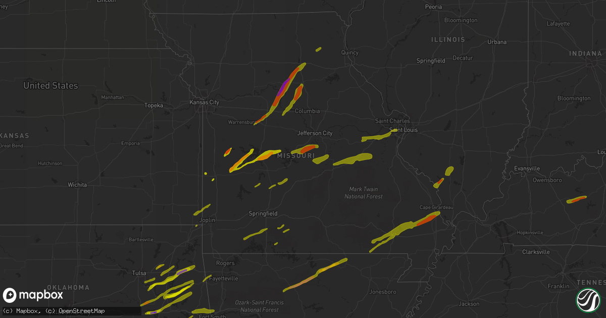
Hail Map in Missouri on April 3, 2014
Get this storm
April 3 map
$229
one time, instant access
Download today. No call, no setup
Keep the $229
Bought the map and want the full workflow? Apply the entire $229 to a subscription within 7 days. None of it is wasted.
Every map, not just this one
This buys you this map. Subscription and you get every map we run, in the markets you choose from a few cities to whole states to nationwide. Plus real-time alerts the moment a storm fires.
Contact data
Name, contact info, occupancy, even credit band for addresses in the footprint. You go from where it hit to who to call.
Become the source they trust
Unlimited branding weather history reports on demand. You already have the documented answer ready for the property owner, and you are the one who showed up with it.
Property data and RoofTrace estimates
Pull up any address you have got, its value and the exact code rules for that jurisdiction, straight from One Click Code. Then RoofTrace estimates the squares, pitch, and roof value, priced the way you price.
Storm reports in Missouri
Missouri
| Date | Description |
|---|---|
| 04/03/20146:48 PM CDT | Delayed report of a picture from social media showing a tree was blown down off evans road south of lake springfield. |
| 04/03/20146:25 PM CDT | A local report indicates 1.25 inch wind near 3 SE NOVELTY |
| 04/03/20146:20 PM CDT | Shingles blown off roof. |
| 04/03/20146:15 PM CDT | Large tree down across highway 133 just south of the van cleve area. |
| 04/03/20146:15 PM CDT | Trees blown down in van cleve. |
| 04/03/20146:15 PM CDT | Large tree down across highway 133 just south of the van cleve area. |
| 04/03/20146:02 PM CDT | Confirmed tornado spotted by missouri troop f |
| 04/03/20145:48 PM CDT | Multiple trees blown down...most trees were 18 to 20 inches in diameter |
| 04/03/20145:48 PM CDT | A local report indicates 1.00 inch wind near S MACON |
| 04/03/20145:45 PM CDT | Trees downed. Unknown size. |
| 04/03/20145:38 PM CDT | A local report indicates 1.75 inch wind near 2 NE THOMAS HILL RES |
| 04/03/20145:37 PM CDT | Tennis ball size hail in college mound |
| 04/03/20145:37 PM CDT | Tennis ball size hail in college mound |
| 04/03/20145:37 PM CDT | Tennis ball size hail in college mound |
| 04/03/20145:35 PM CDT | A local report indicates 1.00 inch wind near SMITHTON |
| 04/03/20145:31 PM CDT | A local report indicates 1.50 inch wind near 3 SE SEDALIA |
| 04/03/20145:30 PM CDT | Scattered trees down across miller county. |
| 04/03/20145:20 PM CDT | A local report indicates 1.00 inch wind near 3 NW MORA |
| 04/03/20145:20 PM CDT | Hail 2 to 2 1/2 inches in diamter. |
| 04/03/20145:19 PM CDT | A local report indicates 1.25 inch wind near SALISBURY |
| 04/03/20145:15 PM CDT | A local report indicates 1.75 inch wind near 1 W SALISBURY |
| 04/03/20145:15 PM CDT | A local report indicates 1.75 inch wind near SALISBURY |
| 04/03/20145:04 PM CDT | A local report indicates 2.50 inch wind near 9 NNW GLASGOW |
| 04/03/20145:00 PM CDT | Hail covering ground. |
| 04/03/20145:00 PM CDT | A local report indicates 1.00 inch wind near GLASGOW |
| 04/03/20144:50 PM CDT | Size estimated from photo |
| 04/03/20144:50 PM CDT | Delayed social media report from public estimated 60 mph wind gusts and minor tree damage to cedar trees and limbs blown down. |
| 04/03/20144:46 PM CDT | A local report indicates 1.25 inch wind near 8 NE EDWARDS |
| 04/03/20144:30 PM CDT | A local report indicates 1.75 inch wind near 1 N CROSS TIMBERS |
| 04/03/20144:29 PM CDT | A local report indicates 1.50 inch wind near LOWRY CITY |
| 04/03/20144:29 PM CDT | 1-2 foot tree limbs down. |
| 04/03/20144:28 PM CDT | A local report indicates 1.00 inch wind near 4 SW NELSON |
| 04/03/20144:22 PM CDT | Dime sized hail also reported. |
| 04/03/20144:22 PM CDT | A local report indicates 1.75 inch wind near 3 N CROSS TIMBERS |
| 04/03/20144:13 PM CDT | A local report indicates 1.50 inch wind near HUGHESVILLE |
| 04/03/20144:10 PM CDT | Reported at the end of highway mm at docs retreat by the lake. |
| 04/03/20144:00 PM CDT | A local report indicates 1.50 inch wind near 1 S LA MONTE |
| 04/03/20143:31 PM CDT | Tree limbs on road. |
| 04/03/20143:27 PM CDT | A local report indicates 1.00 inch wind near 1 S MOBERLY |
| 04/03/20143:23 PM CDT | A local report indicates 1.00 inch wind near ASBURY |
| 04/03/20143:22 PM CDT | A local report indicates 1.50 inch wind near MOBERLY |
| 04/03/20143:20 PM CDT | A local report indicates 1.25 inch wind near MOBERLY |
| 04/03/20143:17 PM CDT | A local report indicates 1.50 inch wind near HIGBEE |
| 04/03/20142:59 PM CDT | A local report indicates 1.75 inch wind near 4 ENE FAYETTE |
| 04/03/20142:29 PM CDT | A local report indicates 1.00 inch wind near BOONVILLE |
| 04/03/20142:00 PM CDT | Delayed report from social media of golf ball size hail just south of cole camp. Time was estimated by radar. |
| 04/03/20141:50 PM CDT | A local report indicates 1.00 inch wind near 3 NW CROSS TIMBERS |
| 04/03/20141:38 PM CDT | A local report indicates 1.50 inch wind near 3 NE AUGUSTA |
| 04/03/20141:37 PM CDT | Baseball sized hail produced holes in siding and damaged vinyl window sills and gutters. Also...1.3 inches of rain today. Delayed report...time estimated from radar. |
| 04/03/20141:31 PM CDT | Golf ball size hail 1 to 2 miles north of villa eidge |
| 04/03/201412:54 PM CDT | A local report indicates 1.75 inch wind near ROLLA |
| 04/03/201412:51 PM CDT | A local report indicates 1.00 inch wind near 3 E ROLLA |
| 04/03/201412:50 PM CDT | A local report indicates 1.00 inch wind near WAYNESVILLE |
| 04/03/201412:45 PM CDT | Delayed report of a picture of minor damage on social media showing fencing blown down and minor damage to a barn and out buildings with the roof peeled off. A few larg |
| 04/03/201412:35 PM CDT | Delayed report from social media of a picture of one inch hail. Time was estimated. |
| 04/03/201412:15 PM CDT | Delayed report from social media showing a picture of damage to a trampoline thrown into trees and damaged. Time was estimated by radar. |
| 04/03/201412:13 PM CDT | A local report indicates 1.00 inch wind near 2 E HUMANSVILLE |
| 04/03/201412:00 PM CDT | A local report indicates 1.00 inch wind near 2 N DUNNEGAN |
| 04/03/201411:57 AM CDT | A local report indicates 1.00 inch wind near 1 SSE BENNETT SPRINGS |
| 04/03/201411:45 AM CDT | A local report indicates 1.25 inch wind near 2 SW SPOKANE |
| 04/03/201411:15 AM CDT | A local report indicates 1.00 inch wind near 6 NNW DADEVILLE |
| 04/03/201410:33 AM CDT | A local report indicates 1.00 inch wind near 4 ESE HIGHLANDVILLE |
| 04/03/201410:29 AM CDT | A local report indicates 1.00 inch wind near HIGHLANDVILLE |
| 04/03/20148:45 AM CDT | A local report indicates 1.25 inch wind near 2 SW SPOKANE |
| 04/03/20148:20 AM CDT | A local report indicates 1.00 inch wind near 2 N DUNNEGAN |
| 04/02/201411:06 PM CDT | In the community of tilset a report of roof damage. |
| 04/02/201410:05 PM CDT | Trees and power lines down throughout the community. |
| 04/02/20149:44 PM CDT | Multiple trees down in the area. |
| 04/02/20149:40 PM CDT | Thousands of large oak and pine trees were snapped and uprooted. One small shed was destroyed and one larger metal building was de-roofed. Some power and communication |
| 04/02/20149:00 PM CDT | Trees and tree limbs down. One shed damaged. Damage track extended northeast for 8.5 miles to 4.5 miles southeast of puxico. Peak wind estimated at 90 mph. |
| 04/02/20148:53 PM CDT | Quarter inch hail reported. |
| 04/02/20148:23 PM CDT | A local report indicates 74 MPH wind near UNIVERSITY CITY |
| 04/02/20148:22 PM CDT | Relayed from spotter |
| 04/02/20148:21 PM CDT | A local report indicates 1.00 inch wind near WEBSTER GROVES |
| 04/02/20148:17 PM CDT | At big bend and hwy 141. Also at i270 and i44. |
| 04/02/20148:11 PM CDT | A local report indicates 1.00 inch wind near FRONTENAC |
| 04/02/20148:11 PM CDT | A local report indicates a tornado near 5 NE FAIRDEALING |
| 04/02/20148:07 PM CDT | A local report indicates a tornado near 5 NE DONIPHAN |
| 04/02/20148:05 PM CDT | Nickel to quarter size hail between ballwin and manchester |
| 04/02/20148:05 PM CDT | A local report indicates 1.00 inch wind near 1 N ROLLA |
| 04/02/20148:03 PM CDT | Also had 45 mph wind gusts. |
| 04/02/20147:56 PM CDT | A double wide mobile home had about half of its roof blown off. A couple trees and tree limbs were blown down. The tornado was just east of stringtown. |
| 04/02/20147:40 PM CDT | A local report indicates 1.00 inch wind near 5 S GRANDIN |
| 04/02/20147:37 PM CDT | Mix of hail...some stones to the size of quarters |
| 04/02/20147:35 PM CDT | Relayed by missouri troop c |
| 04/02/20147:31 PM CDT | Reported at emergency operations center. |
All States Impacted by Hail Map on April 3, 2014
Cities Impacted by Hail Map on April 3, 2014
- Broken Arrow, OK
- Kansas, OK
- Rose, OK
- Peggs, OK
- Haskell, OK
- Bixby, OK
- Colcord, OK
- Porter, OK
- Twin Oaks, OK
- Coweta, OK
- Locust Grove, OK
- Wagoner, OK
- Chouteau, OK
- Mccurtain, OK
- Keota, OK
- Spiro, OK
- Checotah, OK
- Braggs, OK
- Cookson, OK
- Warner, OK
- Oktaha, OK
- Park Hill, OK
- Tahlequah, OK
- Welling, OK
- Council Hill, OK
- Muskogee, OK
- Bunch, OK
- Henryetta, OK
- Sallisaw, OK
- Gans, OK
- Muldrow, OK
- Roland, OK
- Van Buren, AR
- Stigler, OK
- Pryor, OK
- Inola, OK
- Taft, OK
- Boynton, OK
- Morris, OK
- Hulbert, OK
- Proctor, OK
- Okmulgee, OK
- Fort Gibson, OK
- Quapaw, OK
- Claremore, OK
- Westville, OK
- Summers, AR
- Siloam Springs, AR
- Fayetteville, AR
- McGee, MO
- Bell City, MO
- Williamsville, MO
- Benton, MO
- Wappapello, MO
- Zalma, MO
- Grandin, MO
- Doniphan, MO
- Harviell, MO
- Fairdealing, MO
- Bloomfield, MO
- Oran, MO
- Poplar Bluff, MO
- Scott City, MO
- Puxico, MO
- Chaffee, MO
- Thebes, IL
- Advance, MO
- Dowell, IL
- Elkville, IL
- Du Quoin, IL
- De Soto, IL
- Vergennes, IL
- Mulkeytown, IL
- Murphysboro, IL
- Grand Tower, IL
- Gorham, IL
- Jacob, IL
- Frohna, MO
- Altenburg, MO
- Newark, MO
- Novelty, MO
- New Franklin, MO
- Pilot Grove, MO
- Clark, MO
- Boonville, MO
- Moberly, MO
- Huntsville, MO
- Fayette, MO
- Franklin, MO
- Higbee, MO
- Richards, MO
- Moundville, MO
- Nevada, MO
- El Dorado Springs, MO
- Rockville, MO
- Edwards, MO
- Deepwater, MO
- Lincoln, MO
- Lowry City, MO
- Osceola, MO
- Clinton, MO
- Quincy, MO
- Stover, MO
- Warsaw, MO
- Gravois Mills, MO
- Schell City, MO
- Butler, MO
- Montrose, MO
- Excello, MO
- Blackwater, MO
- Armstrong, MO
- Marshall, MO
- Callao, MO
- Hughesville, MO
- Anabel, MO
- Salisbury, MO
- Clifton Hill, MO
- Macon, MO
- Sedalia, MO
- Nelson, MO
- Gilliam, MO
- Keytesville, MO
- Glasgow, MO
- La Monte, MO
- Slater, MO
- Houstonia, MO
- Bevier, MO
- Jasper, MO
- Oronogo, MO
- Columbus, KS
- Galena, KS
- Asbury, MO
- Weir, KS
- Pittsburg, KS
- Ava, MO
- Long Lane, MO
- Buffalo, MO
- Highlandville, MO
- Galena, MO
- Aurora, MO
- Ozark, MO
- Spokane, MO
- Ponce De Leon, MO
- Bolivar, MO
- Polk, MO
- Kissee Mills, MO
- Seymour, MO
- Oldfield, MO
- Lebanon, MO
- Eldridge, MO
- Windyville, MO
- Caneyville, KY
- Horse Branch, KY
- Morgantown, KY
- Leitchfield, KY
- Millwood, KY
- Henley, MO
- Saint Elizabeth, MO
- Westphalia, MO
- Meta, MO
- Jefferson City, MO
- Eldon, MO
- Tuscumbia, MO
- Eugene, MO
- Saint Thomas, MO
- Lake Ozark, MO
- Ballwin, MO
- Saint Louis, MO
- Brinktown, MO
- Vienna, MO
- Dixon, MO
- Iberia, MO
- Gray Summit, MO
- Union, MO
- Valley Park, MO
- Beaufort, MO
- Pacific, MO
- Eureka, MO
- Wildwood, MO
- Washington, MO
- Labadie, MO
- Villa Ridge, MO
- Saint James, MO
- Rolla, MO
- Leasburg, MO
- Cuba, MO
- Sullivan, MO
- Bourbon, MO
- Richwoods, MO
- Eagle Pass, TX
- Dilley, TX
- Crystal City, TX
- Uvalde, TX
- Quemado, TX
- Era, TX
- Sherman, TX
- Sadler, TX
- Sanger, TX
- Whitesboro, TX
- Pottsboro, TX
- Alvord, TX
- Rosston, TX
- Chico, TX
- Collinsville, TX
- Bridgeport, TX
- Valley View, TX
- Gainesville, TX
- Decatur, TX
- Muenster, TX
- Saint Jo, TX
- Forestburg, TX
- Greenville, TX
- Royse City, TX
- Caddo Mills, TX
- Lindsay, TX
- Bluff Dale, TX
- Tolar, TX
- Krum, TX
- Ponder, TX
- Aubrey, TX
- Pilot Point, TX
- Denton, TX
- Celina, TX
- Paris, TX
- Klondike, TX
- Ladonia, TX
- Roxton, TX
- Pecan Gap, TX
- Commerce, TX
- Cooper, TX
- Stephenville, TX
- Dublin, TX
- Melissa, TX
- Blue Ridge, TX
- Princeton, TX
- Celeste, TX
- Mckinney, TX
- Farmersville, TX
- Prosper, TX
- Little Elm, TX
- Argyle, TX
- Allen, TX
- Plano, TX
- Frisco, TX
- Wolfe City, TX
- Haslet, TX
- Fort Worth, TX
- Azle, TX
- Justin, TX
- Rhome, TX
- China Spring, TX
- Waco, TX
- Valley Mills, TX
- West, TX
- Cresson, TX
- Godley, TX
- Granbury, TX
- Weatherford, TX
- Trenton, TX
- Anna, TX
- Bonham, TX
- Leonard, TX
- Bailey, TX
- Windom, TX
- Mammoth Spring, AR
- Pineville, AR
- Oxford, AR
- Dolph, AR
- Hardy, AR
- Salem, AR
- Brockwell, AR
- Glencoe, AR
- Marshall, AR
- Wideman, AR
- Big Flat, AR
- Calico Rock, AR
- Leslie, AR
- Ash Flat, AR
- Harriet, AR
- Somerville, TN
- Moscow, TN
- Knob Noster, MO
- Marthasville, MO
- Foristell, MO
- Augusta, MO
- Defiance, MO
- Leslie, MO
- Saint Charles, MO
- Fenton, MO
- Chesterfield, MO
- Saint Albans, MO
- Humansville, MO
- Stockton, MO
- Flemington, MO
- Fair Play, MO
- Dunnegan, MO
- Dadeville, MO
- Weaubleau, MO
- Wheatland, MO
- Arcola, MO
- Greenfield, MO
- Rocky Mount, MO
- Loose Creek, MO
- Kaiser, MO
- Osage Beach, MO
- Linn, MO
- Sunrise Beach, MO
- Bonnots Mill, MO
- Jonesboro, IL
- Alto Pass, IL
- Cobden, IL
- Wolf Lake, IL
- Anna, IL
- Versailles, MO
- Cedar Hill, MO
- Catawissa, MO
- House Springs, MO
- Bardstown, KY
- Springfield, KY
- Crane, MO
- Watts, OK
- Watson, AR
- Weleetka, OK
- Eufaula, OK
- Vian, OK
- Coffeeville, MS
- Pearsall, TX
- Houston, MS
- Okolona, MS
- Grand Saline, TX
- Canton, TX
- Urbana, MO
- Salina, OK
- Cromwell, KY
- Clarkson, KY
- Chadwick, MO
- Wyandotte, OK
- Carlton, TX
- Hico, TX
- Goldthwaite, TX
- Mullin, TX
- Willow City, TX
- Llano, TX
- Fredericksburg, TX
- Round Mountain, TX
- Waynesville, MO
- Laquey, MO
- Richland, MO
- Hermitage, MO
- Preston, MO
- Cross Timbers, MO
- Macks Creek, MO
- Sturdivant, MO
- Quinlan, TX
- Richardson, TX
- Smithton, MO
- Fruitvale, TX
- Edgewood, TX
- Alba, TX
- Boston, KY
- New Haven, KY
- Ullin, IL
- Tamms, IL
- Garfield, AR
- Pea Ridge, AR
- Bella Vista, AR
- Bentonville, AR
- Seligman, MO
- De Kalb, TX
- New Boston, TX
- Rocksprings, TX
- Omaha, IL
- Ridgway, IL
- De Leon, TX
- Realitos, TX
- Hebbronville, TX
- Laredo, TX
- Walker, MO
- Cole Camp, MO
- Wiseman, AR
- Rich Hill, MO
- Appleton City, MO
- Morrison, MO
- Chamois, MO
- Hermann, MO
- Mount Sterling, MO
- Duke, MO
- Devils Elbow, MO
- Fort Leonard Wood, MO
- Saint Robert, MO
- Newburg, MO
- The Colony, TX
- Couch, MO
- Violet Hill, AR
- Ravenden, AR
- Pocahontas, AR
- Brownwood, MO
- Camp, AR
- Gatewood, MO
- Myrtle, MO
- Horseshoe Bend, AR
- Fisk, MO
- Onia, AR
- Adair, OK
- Quitman, TX
- Mineola, TX
- Talco, TX
- Bogata, TX
- Winnfield, LA
- Winslow, AR
- Elkins, AR
- Wilburton, OK
- Ozona, TX
- La Pryor, TX
- Zephyr, TX
- Early, TX
- Climax Springs, MO
- Harwood, MO
- Roach, MO
- Louisburg, MO
- Marquand, MO
- Denison, TX
- Bells, TX
- Beggs, OK
- Wiergate, TX
- Brookeland, TX
- Bronson, TX
- Broaddus, TX
- Mason, TX
- Doss, TX
- Big Wells, TX
- Asherton, TX
- Cotulla, TX
- Oak Ridge, MO
- Evant, TX
- Hamilton, TX
- Aledo, TX
- Green Ridge, MO
- Ionia, MO
- Windsor, MO
- Stringtown, OK
- Atoka, OK
- Calliham, TX
- Tilden, TX
- Comanche, TX
- Orange Grove, TX
- Leonard, MO
- Urich, MO
- Arnold, MO
- Imperial, MO
- Eucha, OK
- Bristow, IN
- Saint Meinrad, IN
- Coldwater, MS
- Hernando, MS
- Sarah, MS
- Senatobia, MS
- Simms, TX
- Avery, TX
- Huntsville, AR
- Wesley, AR
- Como, TX
- Yantis, TX
- Emory, TX
- Pickton, TX
- Winnsboro, TX
- Gustine, TX
- Van, TX
- Robeline, LA
- Leakey, TX
- Milltown, IN
- Marengo, IN
- Berryville, AR
- Elizabethtown, KY
- Snow, OK
- Nashoba, OK
- Savoy, TX
- Whitewright, TX
- Pleasanton, TX
- Jourdanton, TX
- Mountain Home, TX
- Junction, TX
- Harper, TX
- Bruni, TX
- Mirando City, TX
- Comfort, TX
- Waldo, AR
- Batesville, TX
- George West, TX
- Florence, MO
- Fortuna, MO
- Robstown, TX
- Lonedell, MO
- Tunas, MO
- Greenville, MO
- Sulphur Springs, AR
- Gravette, AR
- Rogers, AR
- Mounds, OK
- Tupelo, MS
- Flower Mound, TX
- Lake Dallas, TX
- Lewisville, TX
- Moore, TX
- Bigfoot, TX
- Campbellton, TX
- Jacksonville, MO
- Marble Hill, MO
- Jackson, MO
- Leopold, MO
- Cape Girardeau, MO
- Whitewater, MO
- Burfordville, MO
- Olive Branch, IL
- Pulaski, IL
- Garland, TX
- Sachse, TX
- Gillett, AR
- Syracuse, MO
- Oak Grove, LA
- Marthaville, LA
- Sandia, TX
- English, IN
- Half Way, MO
- Hartford, KY
- Fordsville, KY
- Theodosia, MO
- Thornfield, MO
- Wasola, MO
- Noble, MO
- Squires, MO
- Clayton, OK
- Jasper, AR
- Florien, LA
- Many, LA
- Terrell, TX
- Anderson, TX
- Mora, MO
- Rosebud, MO
- Owensville, MO
- Seneca, MO
- Otterville, MO
- Eldorado, IL
- Dry Prong, LA
- Bentley, LA
- Paradise, TX
- Lipan, TX
- Campbell, TX
- Natchitoches, LA
- Natchez, LA
- Oilton, TX
- Madison, MO
- Lockwood, MO
- Forney, TX
- Hattieville, AR
- Pollock, LA
- Montgomery City, MO
- Chetopa, KS
- Dike, TX
- Sulphur Springs, TX
- Van Alstyne, TX
- Centerville, TX
- Saline, LA
- Jonesboro, LA
- Lone Oak, TX
- Olean, MO
- Russellville, MO
- Bunceton, MO
- Bland, MO
- Gerald, MO
- Belle, MO
- Columbia, MO
- Fort Scott, KS
- Deerfield, MO
- Olaton, KY
- Falls Of Rough, KY
- Bronaugh, MO
- Willisburg, KY
- Carl Junction, MO
- Hartshorne, OK
- Neosho, MO
- Pontotoc, MS
- Bokchito, OK
- Blossom, TX
- Stuttgart, AR
- De Witt, AR
- Sunnyvale, TX
- Rockwall, TX
- Mesquite, TX
- Wylie, TX
- Corpus Christi, TX
- Emden, MO
- Shelbina, MO
- Hunnewell, MO
- Brackettville, TX
- Pittsburg, MO
- Camdenton, MO
- Loretto, KY
- Fulton, MS
- Hawesville, KY
- Eureka Springs, AR
- Cecilia, KY
- Eastview, KY
- Pineville, MO
- Centerton, AR
- Boyd, TX
- Ben Franklin, TX
- Cumby, TX
- Hendrix, OK
- Wills Point, TX
- Buffalo, TX
- Purmela, TX
- Jonesboro, TX
- Stamps, AR
- Lewisville, AR
- Glen Rose, TX
- Pineland, TX
- Ingram, TX
- Kerrville, TX
- Calhoun, MO
- Waterloo, IL
- New Haven, IL
- Equality, IL
- Millersville, MO
- Van Buren, MO
- Redbird, OK
- Cedarville, AR
- Buckner, AR
- Annona, TX
- Cookville, TX
- Omaha, TX
- Roanoke, TX
- Hemphill, TX
- Williamstown, KY
- Corinth, KY
- Berry, KY
- Falmouth, KY
- Holliday, MO
- Rocheport, MO
- Vichy, MO
- Lewisport, KY
- Uniontown, MO
- Irvine, KY
- Clay City, KY
- Ravenna, KY
- Hodgenville, KY
- Patton, MO
- Sparta, MO
- Springfield, MO
- Nixa, MO
- Bradley, AR
- Dallas, TX
- Point, TX
- Pittsboro, MS
- Lincoln, AR
- Clarence, MO
- Robertsville, MO
- Wentzville, MO
- O'Fallon, MO
- Fulton, MO
- Mokane, MO
- Steedman, MO
- Boonville, IN
- Campbell Hill, IL
- Rockwood, IL
- Hudson, KY
- McDaniels, KY
- Dundee, KY
- Big Clifty, KY
- Phillipsburg, MO
- Vienna, IL
- Cypress, IL
- Fair Grove, MO
- Walnut Shade, MO
- Chestnutridge, MO
- Spavinaw, OK
- Catoosa, OK
- Porum, OK
- Kingston, OK
- Hodgen, OK
- Heavener, OK
- Byhalia, MS
- Collierville, TN
- Nettleton, MS
- Plantersville, MS
- Coahoma, MS
- Dundee, MS
- Shannon, MS
- Vardaman, MS
- Calhoun City, MS
- Derma, MS
- Texarkana, AR
- Hugo, OK
- Camden, AR
- Tillar, AR
- Coppell, TX
- Cleburne, TX
- Oelwein, IA
- Hartsburg, MO
- Ashland, MO
- Foster, MO
- Ferdinand, IN
- Hillsboro, MO
- Dittmer, MO
- Liberal, MO
- Mill Spring, MO
- Silva, MO
- Huron, TN
- Luray, TN
- Beech Bluff, TN
- Henderson, TN
- Kinta, OK
- Red Oak, OK
- Bradleyville, MO
- Chelsea, OK
- Eads, TN
- Tunica, MS
- Big Creek, MS
- Crenshaw, MS
- Summerfield, LA
- Haynesville, LA
- Lillie, LA
- Mount Pleasant, TX
- North Richland Hills, TX
- Keller, TX
- Kaufman, TX
- Quitman, LA
- Olla, LA
- Tullos, LA
- Columbia, LA
- Goldonna, LA
- Bedias, TX
- Yancey, TX
- Columbia, IL
- Valmeyer, IL
- Junction, IL
- Shawneetown, IL
- Stoutland, MO
- Steelville, MO
- Conway, MO
- Niangua, MO
- McCune, KS
- Cherokee, KS
- Clever, MO
- Billings, MO
- Reeds Spring, MO
- Washburn, MO
- Powell, MO
- Canehill, AR
- Whiteville, TN
- Hampton, AR
- Harrell, AR
- Houlka, MS
- Garland City, AR
- Fouke, AR
- Doddridge, AR
- Nevada, TX
- Crowley, TX
- Sikes, LA
- Montgomery, LA
- Deville, LA
- Pineville, LA
- Clifton, TX
- Gatesville, TX
- Charlotte, TX
- Benton, IL
- Sesser, IL
- Clarksburg, MO
- Sturgeon, MO
- Harrisburg, MO
- Kingdom City, MO
- Williamsburg, MO
- Stanton, KY
- Sturgis, KY
- Morganfield, KY
- Sonora, KY
- White Mills, KY
- Beaver Dam, KY
- Mindenmines, MO
- Brookline, MO
- Republic, MO
- Marshfield, MO
- Elkland, MO
- Green Forest, AR
- Oak Grove, AR
- Oakland, TN
- Williston, TN
- Rossville, TN
- Louann, AR
- Charleston, AR
- Brashear, TX
- Haltom City, TX
- Naval Air Station Jrb, TX
- Gladewater, TX
- Kilgore, TX
- Zavalla, TX
- Bryan, TX
- San Diego, TX
- Cairo, MO
- Tipton, MO
- Barnett, MO
- Arcadia, KS
- Depauw, IN
- Ramsey, IN
- Grantsburg, IN
- Ava, IL
- Santa Claus, IN
- Lamar, IN
- Cannelton, IN
- Lamar, MO
- Jerico Springs, MO
- Golden City, MO
- Mount Vernon, IN
- Uniontown, KY
- Mount Pleasant, AR
- Sidney, AR
- Alton, MO
- Fremont, MO
- Hindsville, AR
- Alma, AR
- Webbers Falls, OK
- Bolivar, TN
- Hickory Valley, TN
- Coalgate, OK
- Pittsburg, OK
- Bennington, OK
- Gordonville, TX
- Calera, OK
- Pattonville, TX
- Colbert, OK
- Honey Grove, TX
- Howe, TX
- Sulphur Bluff, TX
- Deport, TX
- Lake Creek, TX
- Cartwright, OK
- Texarkana, TX
- Mineral Springs, AR
- Gunter, TX
- Detroit, TX
- Dodson, LA
- Gilmer, TX
- Del Rio, TX
- Comstock, TX
- High Ridge, MO
- Barnhart, MO
- Crocker, MO
- Waltonville, IL
- Newburgh, IN
- Lawson, MO
- Fairland, OK
- Goreville, IL
- Marion, IL
- Prairie Grove, AR
- Jefferson, TX
- Sheldon, MO
- Ethel, AR
- Banner, MS
- Booneville, AR
- Jay, OK
- Ravenna, TX
- Mer Rouge, LA
- Leesville, LA
- Pitkin, LA
- Deridder, LA
- Bethel, MO
- Brumley, MO
- Hardinsburg, KY
- Cave In Rock, IL
- Crab Orchard, KY
- Lodi, MO
- Clubb, MO
- Raymondville, MO
- Gipsy, MO
- Cherokee Village, AR
- Mount Judea, AR
- Witts Springs, AR
- Lowndes, MO
- McClure, IL
- Ridgedale, MO
- Hollister, MO
- Kirbyville, MO
- Cedarcreek, MO
- Omaha, AR
- Shell Knob, MO
- Big Cabin, OK
- Atkins, AR
- Morrilton, AR
- Solgohachia, AR
- Stonewall, OK
- Grady, AR
- Altheimer, AR
- Rattan, OK
- Cleveland, MS
- Merigold, MS
- Ivanhoe, TX
- Telephone, TX
- Madill, OK
- Stephens, AR
- Eupora, MS
- Tioga, TX
- Georgetown, LA
- Mathis, TX
- Rudy, AR
- Uniontown, AR
- Norfork, AR
- Grovespring, MO
- Melbourne, AR
- Mountain View, AR
- Saint Clair, MO
- Rumsey, KY
- Harrisburg, IL
- Raleigh, IL
- Buncombe, IL
- Makanda, IL
- Edgar Springs, MO
- Evanston, IN
- Tell City, IN
- Bluejacket, OK
- Miami, OK
- Welch, OK
- Pinson, TN
- Medon, TN
- Toone, TN
- Marvell, AR
- Holly Grove, AR
- Almyra, AR
- Grapevine, TX
- Colfax, LA
- Longview, TX
- College Station, TX
- Holts Summit, MO
- New Bloomfield, MO
- Tebbetts, MO
- Ulman, MO
- Milo, MO
- Rogersville, MO
- Vinita, OK
- Witter, AR
- Kingston, AR
- Gore, OK
- Dustin, OK
- West Fork, AR
- Natural Dam, AR
- Chester, AR
- Petty, TX
- Rosston, AR
- Maud, TX
- Hooks, TX
- Bastrop, LA
- Rayville, LA
- Brownwood, TX
- Pottsville, TX
- Priddy, TX
- Iola, TX
- Coulterville, IL
- Rhineland, MO
- Linn Creek, MO
- Portland, MO
- Stamping Ground, KY
- Owenton, KY
- Sadieville, KY
- Falcon, MO
- Jerome, MO
- Winona, MO
- Hiwasse, AR
- Decatur, AR
- Eagle Rock, MO
- Cassville, MO
- Parthenon, AR
- Powderly, TX
- Arthur City, TX
- Grant, OK
- Star City, AR
- Yorktown, AR
- Bernice, LA
- Holcomb, MS
- Grenada, MS
- Pittsburg, TX
- Leesburg, TX
- Bearden, AR
- Lindale, TX
- Provencal, LA
- Melrose, LA
- Cloutierville, LA
- Belmont, LA
- Campti, LA
- Chatham, LA
- Jewett, TX


