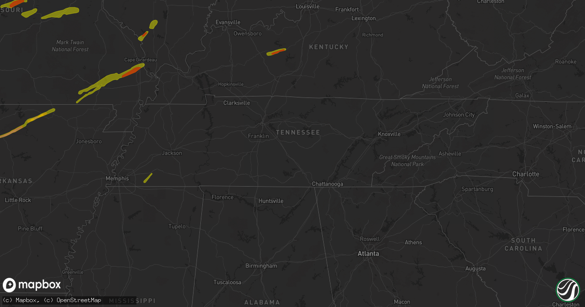
Hail Map in Tennessee on April 3, 2014
Get this storm
April 3 map
$229
one time, instant access
Download today. No call, no setup
Keep the $229
Bought the map and want the full workflow? Apply the entire $229 to a subscription within 7 days. None of it is wasted.
Every map, not just this one
This buys you this map. Subscription and you get every map we run, in the markets you choose from a few cities to whole states to nationwide. Plus real-time alerts the moment a storm fires.
Contact data
Name, contact info, occupancy, even credit band for addresses in the footprint. You go from where it hit to who to call.
Become the source they trust
Unlimited branding weather history reports on demand. You already have the documented answer ready for the property owner, and you are the one who showed up with it.
Property data and RoofTrace estimates
Pull up any address you have got, its value and the exact code rules for that jurisdiction, straight from One Click Code. Then RoofTrace estimates the squares, pitch, and roof value, priced the way you price.
Storm reports in Tennessee
Tennessee
| Date | Description |
|---|---|
| 04/03/20146:29 AM CDT | Trees down on roadway at granville hwy and sheperdsville hwy intersection |
| 04/03/20146:26 AM CDT | A tree was reported down on a van at the smith county bus garage. |
| 04/03/20146:26 AM CDT | Telephone poles snapped at the 1400 block of west jefferson pike in walterhill. |
| 04/03/20146:20 AM CDT | Spotter reported one uprooted tree and several snapped trees along with damaged carports at central valley rd and webb lane. |
| 04/03/20146:20 AM CDT | Large tree limb snapped in the town of christiana. |
| 04/03/20146:11 AM CDT | An nws storm survey team determined that the roof blown off a bp gas station and car wash in northern smyrna was caused by 80 mph straight line winds. |
| 04/03/20145:29 AM CDT | A tree down on a car at 865 bellevue apartments. |
| 04/03/20145:29 AM CDT | Several trees down at falcon creek subdivision in franklin |
| 04/03/20145:10 AM CDT | A semi truck was blown over on hwy 50 west at the centerville city limit. |
| 04/03/20145:05 AM CDT | A tree was reported down on hwy 100 west just outside of centerville. |
| 04/03/20144:56 AM CDT | Trees down on hwy 230 at piney river bridge road. |
| 04/03/20144:51 AM CDT | Trees were reported down on wades branch road about 8 miles west of centerville. |
| 04/03/20144:50 AM CDT | A roof was blown off a home in loretto. |
| 04/03/20144:41 AM CDT | A tree was reported down on hwy 412 near beasley road. The tree was completely blocking the roadway. |
| 04/03/20144:33 AM CDT | Two trees reported down on hwy 438 near paw paw road 3 miles nw of linden. |
| 04/03/20144:33 AM CDT | A tree was blocking bethel road off highway 13 outside of linden. |
| 04/03/20144:20 AM CDT | County em reports a tree through a house and about 5 barns completely destroyed |
| 04/03/20143:58 AM CDT | A local report indicates 1.00 inch wind near JACKSON |
| 04/03/20143:45 AM CDT | A few trees fell on power lines and one barn destroyed. |
| 04/03/20143:10 AM CDT | Nickel to quarter size hail reported in fayette county |
All States Impacted by Hail Map on April 3, 2014
Cities Impacted by Hail Map on April 3, 2014
- Broken Arrow, OK
- Kansas, OK
- Rose, OK
- Peggs, OK
- Haskell, OK
- Bixby, OK
- Colcord, OK
- Porter, OK
- Twin Oaks, OK
- Coweta, OK
- Locust Grove, OK
- Wagoner, OK
- Chouteau, OK
- Mccurtain, OK
- Keota, OK
- Spiro, OK
- Checotah, OK
- Braggs, OK
- Cookson, OK
- Warner, OK
- Oktaha, OK
- Park Hill, OK
- Tahlequah, OK
- Welling, OK
- Council Hill, OK
- Muskogee, OK
- Bunch, OK
- Henryetta, OK
- Sallisaw, OK
- Gans, OK
- Muldrow, OK
- Roland, OK
- Van Buren, AR
- Stigler, OK
- Pryor, OK
- Inola, OK
- Taft, OK
- Boynton, OK
- Morris, OK
- Hulbert, OK
- Proctor, OK
- Okmulgee, OK
- Fort Gibson, OK
- Quapaw, OK
- Claremore, OK
- Westville, OK
- Summers, AR
- Siloam Springs, AR
- Fayetteville, AR
- McGee, MO
- Bell City, MO
- Williamsville, MO
- Benton, MO
- Wappapello, MO
- Zalma, MO
- Grandin, MO
- Doniphan, MO
- Harviell, MO
- Fairdealing, MO
- Bloomfield, MO
- Oran, MO
- Poplar Bluff, MO
- Scott City, MO
- Puxico, MO
- Chaffee, MO
- Thebes, IL
- Advance, MO
- Dowell, IL
- Elkville, IL
- Du Quoin, IL
- De Soto, IL
- Vergennes, IL
- Mulkeytown, IL
- Murphysboro, IL
- Grand Tower, IL
- Gorham, IL
- Jacob, IL
- Frohna, MO
- Altenburg, MO
- Newark, MO
- Novelty, MO
- New Franklin, MO
- Pilot Grove, MO
- Clark, MO
- Boonville, MO
- Moberly, MO
- Huntsville, MO
- Fayette, MO
- Franklin, MO
- Higbee, MO
- Richards, MO
- Moundville, MO
- Nevada, MO
- El Dorado Springs, MO
- Rockville, MO
- Edwards, MO
- Deepwater, MO
- Lincoln, MO
- Lowry City, MO
- Osceola, MO
- Clinton, MO
- Quincy, MO
- Stover, MO
- Warsaw, MO
- Gravois Mills, MO
- Schell City, MO
- Butler, MO
- Montrose, MO
- Excello, MO
- Blackwater, MO
- Armstrong, MO
- Marshall, MO
- Callao, MO
- Hughesville, MO
- Anabel, MO
- Salisbury, MO
- Clifton Hill, MO
- Macon, MO
- Sedalia, MO
- Nelson, MO
- Gilliam, MO
- Keytesville, MO
- Glasgow, MO
- La Monte, MO
- Slater, MO
- Houstonia, MO
- Bevier, MO
- Jasper, MO
- Oronogo, MO
- Columbus, KS
- Galena, KS
- Asbury, MO
- Weir, KS
- Pittsburg, KS
- Ava, MO
- Long Lane, MO
- Buffalo, MO
- Highlandville, MO
- Galena, MO
- Aurora, MO
- Ozark, MO
- Spokane, MO
- Ponce De Leon, MO
- Bolivar, MO
- Polk, MO
- Kissee Mills, MO
- Seymour, MO
- Oldfield, MO
- Lebanon, MO
- Eldridge, MO
- Windyville, MO
- Caneyville, KY
- Horse Branch, KY
- Morgantown, KY
- Leitchfield, KY
- Millwood, KY
- Henley, MO
- Saint Elizabeth, MO
- Westphalia, MO
- Meta, MO
- Jefferson City, MO
- Eldon, MO
- Tuscumbia, MO
- Eugene, MO
- Saint Thomas, MO
- Lake Ozark, MO
- Ballwin, MO
- Saint Louis, MO
- Brinktown, MO
- Vienna, MO
- Dixon, MO
- Iberia, MO
- Gray Summit, MO
- Union, MO
- Valley Park, MO
- Beaufort, MO
- Pacific, MO
- Eureka, MO
- Wildwood, MO
- Washington, MO
- Labadie, MO
- Villa Ridge, MO
- Saint James, MO
- Rolla, MO
- Leasburg, MO
- Cuba, MO
- Sullivan, MO
- Bourbon, MO
- Richwoods, MO
- Eagle Pass, TX
- Dilley, TX
- Crystal City, TX
- Uvalde, TX
- Quemado, TX
- Era, TX
- Sherman, TX
- Sadler, TX
- Sanger, TX
- Whitesboro, TX
- Pottsboro, TX
- Alvord, TX
- Rosston, TX
- Chico, TX
- Collinsville, TX
- Bridgeport, TX
- Valley View, TX
- Gainesville, TX
- Decatur, TX
- Muenster, TX
- Saint Jo, TX
- Forestburg, TX
- Greenville, TX
- Royse City, TX
- Caddo Mills, TX
- Lindsay, TX
- Bluff Dale, TX
- Tolar, TX
- Krum, TX
- Ponder, TX
- Aubrey, TX
- Pilot Point, TX
- Denton, TX
- Celina, TX
- Paris, TX
- Klondike, TX
- Ladonia, TX
- Roxton, TX
- Pecan Gap, TX
- Commerce, TX
- Cooper, TX
- Stephenville, TX
- Dublin, TX
- Melissa, TX
- Blue Ridge, TX
- Princeton, TX
- Celeste, TX
- Mckinney, TX
- Farmersville, TX
- Prosper, TX
- Little Elm, TX
- Argyle, TX
- Allen, TX
- Plano, TX
- Frisco, TX
- Wolfe City, TX
- Haslet, TX
- Fort Worth, TX
- Azle, TX
- Justin, TX
- Rhome, TX
- China Spring, TX
- Waco, TX
- Valley Mills, TX
- West, TX
- Cresson, TX
- Godley, TX
- Granbury, TX
- Weatherford, TX
- Trenton, TX
- Anna, TX
- Bonham, TX
- Leonard, TX
- Bailey, TX
- Windom, TX
- Mammoth Spring, AR
- Pineville, AR
- Oxford, AR
- Dolph, AR
- Hardy, AR
- Salem, AR
- Brockwell, AR
- Glencoe, AR
- Marshall, AR
- Wideman, AR
- Big Flat, AR
- Calico Rock, AR
- Leslie, AR
- Ash Flat, AR
- Harriet, AR
- Somerville, TN
- Moscow, TN
- Knob Noster, MO
- Marthasville, MO
- Foristell, MO
- Augusta, MO
- Defiance, MO
- Leslie, MO
- Saint Charles, MO
- Fenton, MO
- Chesterfield, MO
- Saint Albans, MO
- Humansville, MO
- Stockton, MO
- Flemington, MO
- Fair Play, MO
- Dunnegan, MO
- Dadeville, MO
- Weaubleau, MO
- Wheatland, MO
- Arcola, MO
- Greenfield, MO
- Rocky Mount, MO
- Loose Creek, MO
- Kaiser, MO
- Osage Beach, MO
- Linn, MO
- Sunrise Beach, MO
- Bonnots Mill, MO
- Jonesboro, IL
- Alto Pass, IL
- Cobden, IL
- Wolf Lake, IL
- Anna, IL
- Versailles, MO
- Cedar Hill, MO
- Catawissa, MO
- House Springs, MO
- Bardstown, KY
- Springfield, KY
- Crane, MO
- Watts, OK
- Watson, AR
- Weleetka, OK
- Eufaula, OK
- Vian, OK
- Coffeeville, MS
- Pearsall, TX
- Houston, MS
- Okolona, MS
- Grand Saline, TX
- Canton, TX
- Urbana, MO
- Salina, OK
- Cromwell, KY
- Clarkson, KY
- Chadwick, MO
- Wyandotte, OK
- Carlton, TX
- Hico, TX
- Goldthwaite, TX
- Mullin, TX
- Willow City, TX
- Llano, TX
- Fredericksburg, TX
- Round Mountain, TX
- Waynesville, MO
- Laquey, MO
- Richland, MO
- Hermitage, MO
- Preston, MO
- Cross Timbers, MO
- Macks Creek, MO
- Sturdivant, MO
- Quinlan, TX
- Richardson, TX
- Smithton, MO
- Fruitvale, TX
- Edgewood, TX
- Alba, TX
- Boston, KY
- New Haven, KY
- Ullin, IL
- Tamms, IL
- Garfield, AR
- Pea Ridge, AR
- Bella Vista, AR
- Bentonville, AR
- Seligman, MO
- De Kalb, TX
- New Boston, TX
- Rocksprings, TX
- Omaha, IL
- Ridgway, IL
- De Leon, TX
- Realitos, TX
- Hebbronville, TX
- Laredo, TX
- Walker, MO
- Cole Camp, MO
- Wiseman, AR
- Rich Hill, MO
- Appleton City, MO
- Morrison, MO
- Chamois, MO
- Hermann, MO
- Mount Sterling, MO
- Duke, MO
- Devils Elbow, MO
- Fort Leonard Wood, MO
- Saint Robert, MO
- Newburg, MO
- The Colony, TX
- Couch, MO
- Violet Hill, AR
- Ravenden, AR
- Pocahontas, AR
- Brownwood, MO
- Camp, AR
- Gatewood, MO
- Myrtle, MO
- Horseshoe Bend, AR
- Fisk, MO
- Onia, AR
- Adair, OK
- Quitman, TX
- Mineola, TX
- Talco, TX
- Bogata, TX
- Winnfield, LA
- Winslow, AR
- Elkins, AR
- Wilburton, OK
- Ozona, TX
- La Pryor, TX
- Zephyr, TX
- Early, TX
- Climax Springs, MO
- Harwood, MO
- Roach, MO
- Louisburg, MO
- Marquand, MO
- Denison, TX
- Bells, TX
- Beggs, OK
- Wiergate, TX
- Brookeland, TX
- Bronson, TX
- Broaddus, TX
- Mason, TX
- Doss, TX
- Big Wells, TX
- Asherton, TX
- Cotulla, TX
- Oak Ridge, MO
- Evant, TX
- Hamilton, TX
- Aledo, TX
- Green Ridge, MO
- Ionia, MO
- Windsor, MO
- Stringtown, OK
- Atoka, OK
- Calliham, TX
- Tilden, TX
- Comanche, TX
- Orange Grove, TX
- Leonard, MO
- Urich, MO
- Arnold, MO
- Imperial, MO
- Eucha, OK
- Bristow, IN
- Saint Meinrad, IN
- Coldwater, MS
- Hernando, MS
- Sarah, MS
- Senatobia, MS
- Simms, TX
- Avery, TX
- Huntsville, AR
- Wesley, AR
- Como, TX
- Yantis, TX
- Emory, TX
- Pickton, TX
- Winnsboro, TX
- Gustine, TX
- Van, TX
- Robeline, LA
- Leakey, TX
- Milltown, IN
- Marengo, IN
- Berryville, AR
- Elizabethtown, KY
- Snow, OK
- Nashoba, OK
- Savoy, TX
- Whitewright, TX
- Pleasanton, TX
- Jourdanton, TX
- Mountain Home, TX
- Junction, TX
- Harper, TX
- Bruni, TX
- Mirando City, TX
- Comfort, TX
- Waldo, AR
- Batesville, TX
- George West, TX
- Florence, MO
- Fortuna, MO
- Robstown, TX
- Lonedell, MO
- Tunas, MO
- Greenville, MO
- Sulphur Springs, AR
- Gravette, AR
- Rogers, AR
- Mounds, OK
- Tupelo, MS
- Flower Mound, TX
- Lake Dallas, TX
- Lewisville, TX
- Moore, TX
- Bigfoot, TX
- Campbellton, TX
- Jacksonville, MO
- Marble Hill, MO
- Jackson, MO
- Leopold, MO
- Cape Girardeau, MO
- Whitewater, MO
- Burfordville, MO
- Olive Branch, IL
- Pulaski, IL
- Garland, TX
- Sachse, TX
- Gillett, AR
- Syracuse, MO
- Oak Grove, LA
- Marthaville, LA
- Sandia, TX
- English, IN
- Half Way, MO
- Hartford, KY
- Fordsville, KY
- Theodosia, MO
- Thornfield, MO
- Wasola, MO
- Noble, MO
- Squires, MO
- Clayton, OK
- Jasper, AR
- Florien, LA
- Many, LA
- Terrell, TX
- Anderson, TX
- Mora, MO
- Rosebud, MO
- Owensville, MO
- Seneca, MO
- Otterville, MO
- Eldorado, IL
- Dry Prong, LA
- Bentley, LA
- Paradise, TX
- Lipan, TX
- Campbell, TX
- Natchitoches, LA
- Natchez, LA
- Oilton, TX
- Madison, MO
- Lockwood, MO
- Forney, TX
- Hattieville, AR
- Pollock, LA
- Montgomery City, MO
- Chetopa, KS
- Dike, TX
- Sulphur Springs, TX
- Van Alstyne, TX
- Centerville, TX
- Saline, LA
- Jonesboro, LA
- Lone Oak, TX
- Olean, MO
- Russellville, MO
- Bunceton, MO
- Bland, MO
- Gerald, MO
- Belle, MO
- Columbia, MO
- Fort Scott, KS
- Deerfield, MO
- Olaton, KY
- Falls Of Rough, KY
- Bronaugh, MO
- Willisburg, KY
- Carl Junction, MO
- Hartshorne, OK
- Neosho, MO
- Pontotoc, MS
- Bokchito, OK
- Blossom, TX
- Stuttgart, AR
- De Witt, AR
- Sunnyvale, TX
- Rockwall, TX
- Mesquite, TX
- Wylie, TX
- Corpus Christi, TX
- Emden, MO
- Shelbina, MO
- Hunnewell, MO
- Brackettville, TX
- Pittsburg, MO
- Camdenton, MO
- Loretto, KY
- Fulton, MS
- Hawesville, KY
- Eureka Springs, AR
- Cecilia, KY
- Eastview, KY
- Pineville, MO
- Centerton, AR
- Boyd, TX
- Ben Franklin, TX
- Cumby, TX
- Hendrix, OK
- Wills Point, TX
- Buffalo, TX
- Purmela, TX
- Jonesboro, TX
- Stamps, AR
- Lewisville, AR
- Glen Rose, TX
- Pineland, TX
- Ingram, TX
- Kerrville, TX
- Calhoun, MO
- Waterloo, IL
- New Haven, IL
- Equality, IL
- Millersville, MO
- Van Buren, MO
- Redbird, OK
- Cedarville, AR
- Buckner, AR
- Annona, TX
- Cookville, TX
- Omaha, TX
- Roanoke, TX
- Hemphill, TX
- Williamstown, KY
- Corinth, KY
- Berry, KY
- Falmouth, KY
- Holliday, MO
- Rocheport, MO
- Vichy, MO
- Lewisport, KY
- Uniontown, MO
- Irvine, KY
- Clay City, KY
- Ravenna, KY
- Hodgenville, KY
- Patton, MO
- Sparta, MO
- Springfield, MO
- Nixa, MO
- Bradley, AR
- Dallas, TX
- Point, TX
- Pittsboro, MS
- Lincoln, AR
- Clarence, MO
- Robertsville, MO
- Wentzville, MO
- O'Fallon, MO
- Fulton, MO
- Mokane, MO
- Steedman, MO
- Boonville, IN
- Campbell Hill, IL
- Rockwood, IL
- Hudson, KY
- McDaniels, KY
- Dundee, KY
- Big Clifty, KY
- Phillipsburg, MO
- Vienna, IL
- Cypress, IL
- Fair Grove, MO
- Walnut Shade, MO
- Chestnutridge, MO
- Spavinaw, OK
- Catoosa, OK
- Porum, OK
- Kingston, OK
- Hodgen, OK
- Heavener, OK
- Byhalia, MS
- Collierville, TN
- Nettleton, MS
- Plantersville, MS
- Coahoma, MS
- Dundee, MS
- Shannon, MS
- Vardaman, MS
- Calhoun City, MS
- Derma, MS
- Texarkana, AR
- Hugo, OK
- Camden, AR
- Tillar, AR
- Coppell, TX
- Cleburne, TX
- Oelwein, IA
- Hartsburg, MO
- Ashland, MO
- Foster, MO
- Ferdinand, IN
- Hillsboro, MO
- Dittmer, MO
- Liberal, MO
- Mill Spring, MO
- Silva, MO
- Huron, TN
- Luray, TN
- Beech Bluff, TN
- Henderson, TN
- Kinta, OK
- Red Oak, OK
- Bradleyville, MO
- Chelsea, OK
- Eads, TN
- Tunica, MS
- Big Creek, MS
- Crenshaw, MS
- Summerfield, LA
- Haynesville, LA
- Lillie, LA
- Mount Pleasant, TX
- North Richland Hills, TX
- Keller, TX
- Kaufman, TX
- Quitman, LA
- Olla, LA
- Tullos, LA
- Columbia, LA
- Goldonna, LA
- Bedias, TX
- Yancey, TX
- Columbia, IL
- Valmeyer, IL
- Junction, IL
- Shawneetown, IL
- Stoutland, MO
- Steelville, MO
- Conway, MO
- Niangua, MO
- McCune, KS
- Cherokee, KS
- Clever, MO
- Billings, MO
- Reeds Spring, MO
- Washburn, MO
- Powell, MO
- Canehill, AR
- Whiteville, TN
- Hampton, AR
- Harrell, AR
- Houlka, MS
- Garland City, AR
- Fouke, AR
- Doddridge, AR
- Nevada, TX
- Crowley, TX
- Sikes, LA
- Montgomery, LA
- Deville, LA
- Pineville, LA
- Clifton, TX
- Gatesville, TX
- Charlotte, TX
- Benton, IL
- Sesser, IL
- Clarksburg, MO
- Sturgeon, MO
- Harrisburg, MO
- Kingdom City, MO
- Williamsburg, MO
- Stanton, KY
- Sturgis, KY
- Morganfield, KY
- Sonora, KY
- White Mills, KY
- Beaver Dam, KY
- Mindenmines, MO
- Brookline, MO
- Republic, MO
- Marshfield, MO
- Elkland, MO
- Green Forest, AR
- Oak Grove, AR
- Oakland, TN
- Williston, TN
- Rossville, TN
- Louann, AR
- Charleston, AR
- Brashear, TX
- Haltom City, TX
- Naval Air Station Jrb, TX
- Gladewater, TX
- Kilgore, TX
- Zavalla, TX
- Bryan, TX
- San Diego, TX
- Cairo, MO
- Tipton, MO
- Barnett, MO
- Arcadia, KS
- Depauw, IN
- Ramsey, IN
- Grantsburg, IN
- Ava, IL
- Santa Claus, IN
- Lamar, IN
- Cannelton, IN
- Lamar, MO
- Jerico Springs, MO
- Golden City, MO
- Mount Vernon, IN
- Uniontown, KY
- Mount Pleasant, AR
- Sidney, AR
- Alton, MO
- Fremont, MO
- Hindsville, AR
- Alma, AR
- Webbers Falls, OK
- Bolivar, TN
- Hickory Valley, TN
- Coalgate, OK
- Pittsburg, OK
- Bennington, OK
- Gordonville, TX
- Calera, OK
- Pattonville, TX
- Colbert, OK
- Honey Grove, TX
- Howe, TX
- Sulphur Bluff, TX
- Deport, TX
- Lake Creek, TX
- Cartwright, OK
- Texarkana, TX
- Mineral Springs, AR
- Gunter, TX
- Detroit, TX
- Dodson, LA
- Gilmer, TX
- Del Rio, TX
- Comstock, TX
- High Ridge, MO
- Barnhart, MO
- Crocker, MO
- Waltonville, IL
- Newburgh, IN
- Lawson, MO
- Fairland, OK
- Goreville, IL
- Marion, IL
- Prairie Grove, AR
- Jefferson, TX
- Sheldon, MO
- Ethel, AR
- Banner, MS
- Booneville, AR
- Jay, OK
- Ravenna, TX
- Mer Rouge, LA
- Leesville, LA
- Pitkin, LA
- Deridder, LA
- Bethel, MO
- Brumley, MO
- Hardinsburg, KY
- Cave In Rock, IL
- Crab Orchard, KY
- Lodi, MO
- Clubb, MO
- Raymondville, MO
- Gipsy, MO
- Cherokee Village, AR
- Mount Judea, AR
- Witts Springs, AR
- Lowndes, MO
- McClure, IL
- Ridgedale, MO
- Hollister, MO
- Kirbyville, MO
- Cedarcreek, MO
- Omaha, AR
- Shell Knob, MO
- Big Cabin, OK
- Atkins, AR
- Morrilton, AR
- Solgohachia, AR
- Stonewall, OK
- Grady, AR
- Altheimer, AR
- Rattan, OK
- Cleveland, MS
- Merigold, MS
- Ivanhoe, TX
- Telephone, TX
- Madill, OK
- Stephens, AR
- Eupora, MS
- Tioga, TX
- Georgetown, LA
- Mathis, TX
- Rudy, AR
- Uniontown, AR
- Norfork, AR
- Grovespring, MO
- Melbourne, AR
- Mountain View, AR
- Saint Clair, MO
- Rumsey, KY
- Harrisburg, IL
- Raleigh, IL
- Buncombe, IL
- Makanda, IL
- Edgar Springs, MO
- Evanston, IN
- Tell City, IN
- Bluejacket, OK
- Miami, OK
- Welch, OK
- Pinson, TN
- Medon, TN
- Toone, TN
- Marvell, AR
- Holly Grove, AR
- Almyra, AR
- Grapevine, TX
- Colfax, LA
- Longview, TX
- College Station, TX
- Holts Summit, MO
- New Bloomfield, MO
- Tebbetts, MO
- Ulman, MO
- Milo, MO
- Rogersville, MO
- Vinita, OK
- Witter, AR
- Kingston, AR
- Gore, OK
- Dustin, OK
- West Fork, AR
- Natural Dam, AR
- Chester, AR
- Petty, TX
- Rosston, AR
- Maud, TX
- Hooks, TX
- Bastrop, LA
- Rayville, LA
- Brownwood, TX
- Pottsville, TX
- Priddy, TX
- Iola, TX
- Coulterville, IL
- Rhineland, MO
- Linn Creek, MO
- Portland, MO
- Stamping Ground, KY
- Owenton, KY
- Sadieville, KY
- Falcon, MO
- Jerome, MO
- Winona, MO
- Hiwasse, AR
- Decatur, AR
- Eagle Rock, MO
- Cassville, MO
- Parthenon, AR
- Powderly, TX
- Arthur City, TX
- Grant, OK
- Star City, AR
- Yorktown, AR
- Bernice, LA
- Holcomb, MS
- Grenada, MS
- Pittsburg, TX
- Leesburg, TX
- Bearden, AR
- Lindale, TX
- Provencal, LA
- Melrose, LA
- Cloutierville, LA
- Belmont, LA
- Campti, LA
- Chatham, LA
- Jewett, TX


