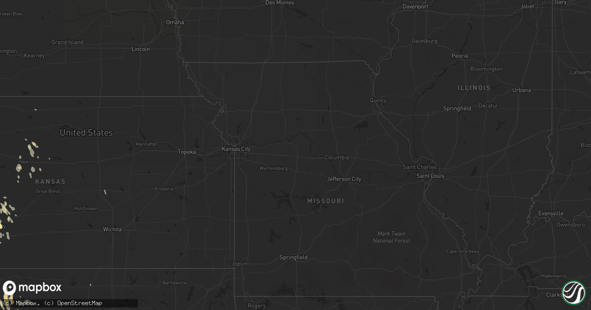
Hail Map in Kansas on April 2, 2012
Get this storm
April 2 map
$229
one time, instant access
Download today. No call, no setup
Keep the $229
Bought the map and want the full workflow? Apply the entire $229 to a subscription within 7 days. None of it is wasted.
Every map, not just this one
This buys you this map. Subscription and you get every map we run, in the markets you choose from a few cities to whole states to nationwide. Plus real-time alerts the moment a storm fires.
Contact data
Name, contact info, occupancy, even credit band for addresses in the footprint. You go from where it hit to who to call.
Become the source they trust
Unlimited branding weather history reports on demand. You already have the documented answer ready for the property owner, and you are the one who showed up with it.
Property data and RoofTrace estimates
Pull up any address you have got, its value and the exact code rules for that jurisdiction, straight from One Click Code. Then RoofTrace estimates the squares, pitch, and roof value, priced the way you price.
Storm reports in Kansas
Kansas
| Date | Description |
|---|---|
| 04/02/20126:55 PM CDT | A local report indicates 1.00 inch wind near 4 SW ANTONINO |
| 04/02/20126:46 PM CDT | A local report indicates 1.75 inch wind near 8 S MONTEZUMA |
| 04/02/20126:45 PM CDT | Hail estimated pea to quarter sized. |
| 04/02/20126:41 PM CDT | A local report indicates 1.75 inch wind near 9 S MONTEZUMA |
| 04/02/20126:41 PM CDT | A local report indicates 1.75 inch wind near 9 SSW MONTEZUMA |
| 04/02/20126:18 PM CDT | A local report indicates 1.75 inch wind near 4 W FOWLER |
| 04/02/20126:08 PM CDT | A local report indicates 1.75 inch wind near 6 NNE MEADE |
| 04/02/20125:55 PM CDT | Report was relayed by media. Ping pong size hail in ditch near garnett road and us highway 283. Time based on radar. |
| 04/02/20125:48 PM CDT | Hail ranged from pea sized to quarter sized. |
| 04/02/20125:47 PM CDT | A local report indicates 1.75 inch wind near 3 SW WRIGHT |
| 04/02/201212:15 AM CDT | The metal roof of the coldwater laundry building was torn off. |
| 04/01/20128:40 PM CDT | A local report indicates 1.00 inch wind near 5 WSW GRAY |
| 04/01/20128:30 PM CDT | A local report indicates 1.00 inch wind near 4 SW HANSTON |
All States Impacted by Hail Map on April 2, 2012
Cities Impacted by Hail Map on April 2, 2012
- Sulphur Springs, TX
- Ragley, LA
- West Monroe, LA
- Eros, LA
- Columbia, LA
- Robeline, LA
- Marthaville, LA
- Henderson, TX
- Frederick, OK
- Baton Rouge, LA
- Bassfield, MS
- Sumrall, MS
- Plains, KS
- Texarkana, AR
- Lewisville, AR
- Fouke, AR
- Garland City, AR
- Harrold, TX
- Tipton, OK
- Zachary, LA
- Burkesville, KY
- Magnolia, AR
- Stephens, AR
- Jackson, AL
- Gainestown, AL
- Uriah, AL
- Plainville, KS
- Natoma, KS
- Pampa, TX
- Bee Spring, KY
- Sweeden, KY
- Schriever, LA
- Deridder, LA
- Reeves, LA
- Dry Creek, LA
- Haworth, OK
- Forgan, OK
- Meade, KS
- Haughton, LA
- Plain Dealing, LA
- Cotton Valley, LA
- Benton, LA
- Princeton, LA
- Woodworth, LA
- Oakdale, LA
- Forest Hill, LA
- Ville Platte, LA
- Elmer, LA
- Hineston, LA
- Glenmora, LA
- Richton, MS
- State Line, MS
- Batchelor, LA
- Lettsworth, LA
- Longview, TX
- Tatum, TX
- Lagrange, IN
- Spring Valley, WI
- Canadian, TX
- Higgins, TX
- Briscoe, TX
- Kinder, LA
- Atlanta, LA
- Wewoka, OK
- Sasakwa, OK
- Ruth, MS
- Bogue Chitto, MS
- McDavid, FL
- Atmore, AL
- Jamestown, ND
- Jud, ND
- Arnett, OK
- Pineville, LA
- Alexandria, LA
- Beldenville, WI
- River Falls, WI
- Cleveland, TX
- Camden, MS
- Wishek, ND
- Pearl River, LA
- Montezuma, KS
- Fowler, KS
- Shamrock, TX
- Wellington, TX
- Seymour, TX
- Munday, TX
- Benjamin, TX
- Oklaunion, TX
- Crowell, TX
- Electra, TX
- Vernon, TX
- Haynesville, LA
- Jackson, MS
- Ridgeland, MS
- Benton, MS
- Chickasha, OK
- Cement, OK
- Knoxville, TN
- Erath, LA
- Barataria, LA
- Quitman, LA
- Jonesboro, LA
- White Pigeon, MI
- Grandfield, OK
- Wills Point, TX
- Fruitvale, TX
- Edgewood, TX
- Beckville, TX
- Lawton, OK
- Temple, OK
- Randlett, OK
- Walters, OK
- Wichita Falls, TX
- Woodward, OK
- Saint Paul, MN
- Silver Creek, MS
- Deville, LA
- Jeanerette, LA
- Coushatta, LA
- Grand Saline, TX
- Osyka, MS
- Wheeler, TX
- Dodson, TX
- Roosevelt, OK
- Brandon, MS
- Flowood, MS
- Pearl, MS
- New Caney, TX
- Dayton, TX
- Splendora, TX
- Lecompte, LA
- San Angelo, TX
- Sarepta, LA
- Cordell, OK
- Gotebo, OK
- Hobart, OK
- Colony, OK
- Gage, OK
- Shattuck, OK
- Newellton, LA
- Center Point, LA
- Livingston, TX
- Gackle, ND
- Ingalls, KS
- Brookhaven, MS
- Crawford, OK
- Cheyenne, OK
- McCall Creek, MS
- Jefferson, TX
- New Iberia, LA
- Delcambre, LA
- Goodrich, TX
- Wannaska, MN
- Green Isle, MN
- Henderson, MN
- Belle Plaine, MN
- Liberty, TX
- Carthage, TX
- Hallsville, TX
- Linden, TX
- Harleton, TX
- Avinger, TX
- Marshall, TX
- Diana, TX
- Mountain View, OK
- Mount Pleasant, TX
- Talco, TX
- Cookville, TX
- Price, TX
- Quanah, TX
- Pitkin, LA
- Burnsville, MN
- Prior Lake, MN
- Savage, MN
- Saltillo, TX
- Headrick, OK
- Elmer, OK
- Snyder, OK
- Altus, OK
- Altus Afb, OK
- Carson, MS
- Annona, TX
- Zavalla, TX
- Rayne, LA
- Kaplan, LA
- Olustee, OK
- Mountain Park, OK
- Hooker, OK
- Hardesty, OK
- Guymon, OK
- Throckmorton, TX
- Fort Supply, OK
- Sontag, MS
- Natchez, MS
- Alto, TX
- Wells, TX
- Kennard, TX
- Abbeville, LA
- Ida, LA
- New Richmond, WI
- Roberts, WI
- Sublette, KS
- Madill, OK
- Gate, OK
- Rosston, OK
- Waurika, OK
- Ryan, OK
- Petrolia, TX
- Byers, TX
- Winfield, TX
- Pittsburg, TX
- Leesburg, TX
- Scroggins, TX
- Mount Vernon, TX
- Minneola, KS
- Arcadia, LA
- Ferriday, LA
- Buna, TX
- Commerce, TX
- Bivins, TX
- Atlanta, TX
- Bernice, LA
- Wellston, OK
- Ballinger, TX
- Rowena, TX
- Coleman, TX
- Miles, TX
- Norton, TX
- Talpa, TX
- Canton, KS
- Galva, KS
- Grayson, LA
- Jonesville, LA
- Canton, MS
- Madison, MS
- Russell, KS
- Silsbee, TX
- May, OK
- Sharon, OK
- Fargo, OK
- Newhebron, MS
- Prentiss, MS
- Mooreland, OK
- Kerens, TX
- Wright, KS
- Timpson, TX
- Edwards, MS
- Hudson, WI
- Converse, LA
- Conroe, TX
- Gloster, MS
- Junction City, AR
- Dodge City, KS
- Satanta, KS
- Wolfe City, TX
- Bayport, MN
- Stillwater, MN
- Houston, TX
- Humble, TX
- Porter, TX
- Kingwood, TX
- Napoleonville, LA
- Shakopee, MN
- Eden Prairie, MN
- Minneapolis, MN
- Overton, TX
- Tylertown, MS
- Montpelier, ND
- Petal, MS
- Tallulah, LA
- Ruston, LA
- Dubach, LA
- Homer, LA
- Pelahatchie, MS
- Channelview, TX
- Lehr, ND
- Mangum, OK
- Duke, OK
- Laverne, OK
- Newton, TX
- Cooper, TX
- Granite, OK
- Willow, OK
- Chatham, LA
- Choudrant, LA
- Ford, KS
- Crystal Springs, MS
- Florence, MS
- Harrisville, MS
- Hazlehurst, MS
- Terry, MS
- Georgetown, MS
- Leitchfield, KY
- Brownsville, KY
- Colfax, WI
- Buckatunna, MS
- Wesson, MS
- Beaumont, TX
- Hattiesburg, MS
- Jetmore, KS
- Spearville, KS
- Hanston, KS
- Kinsley, KS
- Chilton, WI
- Pfeifer, KS
- Victoria, KS
- Chireno, TX
- Hollis, OK
- Vinson, OK
- Davidson, OK
- Childress, TX
- Chillicothe, TX
- Gould, OK
- Eldorado, OK
- Bolton, MS
- Clinton, MS
- Haskell, TX
- Olla, LA
- Spring, TX
- Magnolia, TX
- Tenaha, TX
- Center, TX
- Sikes, LA
- Vaughan, MS
- Mobile, AL
- Broaddus, TX
- Galena Park, TX
- Pollock, LA
- Mccomb, MS
- Lakeville, MN
- Jayess, MS
- Hull, TX
- Fletcher, OK
- Jasper, TX
- Lumberton, MS
- Poplarville, MS
- Mendenhall, MS
- Pinola, MS
- Gulf Breeze, FL
- Shreveport, LA
- Mooringsport, LA
- El Dorado, AR
- Summit, MS
- Saint Amant, LA
- Perryton, TX
- Hastings, MN
- Farmington, MN
- Vermillion, MN
- Hampton, MN
- Rosemount, MN
- Menomonie, WI
- Pickens, MS
- Elko New Market, MN
- La Crosse, KS
- McCracken, KS
- Morton, MS
- Duncan, OK
- Kismet, KS
- Indiahoma, OK
- Chattanooga, OK
- Cache, OK
- Loveland, OK
- Jordan, MN
- Inver Grove Heights, MN
- Saint Paul Park, MN
- Glenwood City, WI
- Knapp, WI
- Downing, WI
- Wilson, WI
- Pickton, TX
- Copeland, KS
- Ensign, KS
- Cimarron, KS
- Crowley, LA
- Estherwood, LA
- Newhope, AR
- Langley, AR
- Dierks, AR
- Umpire, AR
- Hemphill, TX
- South Saint Paul, MN
- Silas, AL
- Waynesboro, MS
- Millry, AL
- Apple Springs, TX
- Franklin, LA
- Warren, TX
- Medford, OK
- Colmesneil, TX
- Delhi, LA
- Rayville, LA
- Kountze, TX
- Wilmot, AR
- Fredonia, ND
- Rusk, TX
- Jacksonville, TX
- Corunna, IN
- Wolcottville, IN
- Hudson, IN
- Kendallville, IN
- Hammon, OK
- Sayre, OK
- Collins, MS
- Vicksburg, MS
- Hockley, TX
- Newcastle, TX
- Long Branch, TX
- Gary, TX
- Nacogdoches, TX
- Garrison, TX
- Mount Enterprise, TX
- Smithdale, MS
- Liberty, MS
- Meadville, MS
- Clinton, LA
- Corrigan, TX
- Ethel, LA
- Jackson, LA
- Norwood, LA
- Groveton, TX
- Trinity, TX
- Baytown, TX
- Alba, TX
- Mineola, TX
- Shongaloo, LA
- Emerson, AR
- Braithwaite, LA
- Boyd, WI
- Stanley, WI
- Hays, KS
- Kokomo, MS
- Sweetwater, OK
- Liberal, KS
- Hugoton, KS
- Lake Charles, LA
- Mount Olive, MS
- Pine Grove, LA
- Ada, OK
- Lone Wolf, OK
- Waldo, AR
- Cyril, OK
- Ninnekah, OK
- Erick, OK
- Baldwin, WI
- Woodville, WI
- Saint Francisville, LA
- Fayette, MS
- Sandy Hook, MS
- Foxworth, MS
- Magnolia, MS
- Mansfield, LA
- Slidell, LA
- Milladore, WI
- Seminary, MS
- Mclean, TX
- Miami, TX
- Rodessa, LA
- Doddridge, AR
- Mena, AR
- Braxton, MS
- Elgin, OK
- Brookshire, TX
- Pleasant Hill, LA
- Pelican, LA
- Burkburnett, TX
- Devol, OK
- Geismar, LA
- Donaldsonville, LA
- Arlington, MN
- Foreman, AR
- Vinegar Bend, AL
- Leedey, OK
- New Augusta, MS
- Leroy, AL
- Henrietta, TX
- Ladonia, TX
- Jena, LA
- Beaumont, MS
- Fort Sill, OK
- Elk Mound, WI
- Tom Bean, TX
- Sherman, TX
- Whitewright, TX
- Joaquin, TX
- Keithville, LA
- Keatchie, LA
- Port Allen, LA
- Rush Springs, OK
- Faxon, OK
- Marksville, LA
- De Kalb, TX
- Goodman, MS
- Oak Vale, MS
- Simsboro, LA
- Bogalusa, LA
- Angie, LA
- Catharine, KS
- Gorham, KS
- Reydon, OK
- Lake Arthur, LA
- Jennings, LA
- Fairfield, TX
- Moselle, MS
- Blair, OK
- Magee, MS
- Gaylord, MN
- Plum City, WI
- Berwick, LA
- Morgan City, LA
- Theriot, LA
- Gibson, LA
- Butler, OK
- Spearman, TX
- Leakesville, MS
- South Haven, MI
- Palmetto, LA
- Melville, LA
- Newport, MN
- Marlow, OK
- Cadott, WI
- Monticello, MS
- Queen City, TX
- Biloxi, MS
- Kenner, LA
- Westwego, LA
- Ellsworth, WI
- Lena, MS
- Clinton, OK
- Foss, OK
- Shelbyville, TX
- Mize, MS
- Ball, LA
- Grand Cane, LA
- Topeka, IN
- Heavener, OK
- Utica, MS
- Purvis, MS
- Booker, TX
- Logansport, LA
- Eau Claire, WI
- Holliday, TX
- Apache, OK
- Crosby, TX
- Winnsboro, TX
- Como, TX
- Clarksville, TX
- Dodson, LA
- Offerle, KS
- Chippewa Falls, WI
- Kirbyville, TX
- Carver, MN
- Norwood Young America, MN
- Cologne, MN
- Bunker Hill, KS
- Waupaca, WI
- Prescott, WI
- Troup, TX
- Weinert, TX
- Grove Hill, AL
- Lillie, LA
- San Augustine, TX
- Tyler, TX
- Denham Springs, LA
- Greenwell Springs, LA
- Gueydan, LA
- Dermott, AR
- Talmoon, MN
- Deer River, MN
- Patterson, LA
- Hollister, OK
- Chaska, MN
- Iowa Park, TX
- Morgantown, KY
- Diberville, MS
- Blanchard, OK
- Amber, OK
- Corn, OK
- Vivian, LA
- Bay Minette, AL
- Summerfield, LA
- Bentonia, MS
- Amite, LA
- Gonzales, LA
- Prairieville, LA
- Oak Grove, LA
- De Queen, AR
- Livingston, LA
- Walker, LA
- Riverton, NE
- Lafitte, LA
- Winnfield, LA
- Emory, TX
- Afton, MN
- Merkel, TX
- Elton, LA
- Lockport, LA
- Milam, TX
- Bronson, TX
- Hawkins, TX
- Lake Elmo, MN
- Centreville, MS
- Bucklin, KS
- Naponee, NE
- Bison, KS
- Church Point, LA
- Brookeland, TX
- Bogata, TX
- Avery, TX
- Buckner, AR
- Kelly, LA
- Roseland, LA
- Lisbon, LA
- Columbia, MS
- Pennington, TX
- Montgomery, LA
- Stamps, AR
- Slaughter, LA
- Wilson, LA
- Dry Prong, LA
- Noble, LA
- Kensington, KS
- Brashear, TX
- Kilgore, TX
- Boyceville, WI
- Simmesport, LA
- Plaucheville, LA
- Holland, MI
- Gulfport, MS
- Downsville, LA
- Calhoun, LA
- Ypsilanti, ND
- Great Falls, SC
- Fort Lawn, SC
- Monterey, LA
- Des Allemands, LA
- Saint Gabriel, LA
- Sunshine, LA
- Winters, TX
- Balko, OK


