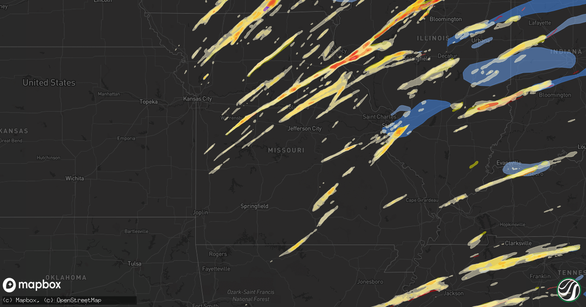
Hail Map in Missouri on March 31, 2023
Get this storm
March 31 map
$229
one time, instant access
Download today. No call, no setup
Keep the $229
Bought the map and want the full workflow? Apply the entire $229 to a subscription within 7 days. None of it is wasted.
Every map, not just this one
This buys you this map. Subscription and you get every map we run, in the markets you choose from a few cities to whole states to nationwide. Plus real-time alerts the moment a storm fires.
Contact data
Name, contact info, occupancy, even credit band for addresses in the footprint. You go from where it hit to who to call.
Become the source they trust
Unlimited branding weather history reports on demand. You already have the documented answer ready for the property owner, and you are the one who showed up with it.
Property data and RoofTrace estimates
Pull up any address you have got, its value and the exact code rules for that jurisdiction, straight from One Click Code. Then RoofTrace estimates the squares, pitch, and roof value, priced the way you price.
Storm reports in Missouri
Missouri
| Date | Description |
|---|---|
| 03/31/20236:59 PM CDT | Tree snapped at base that caused power lines down. |
| 03/31/20236:32 PM CDT | Delayed report. |
| 03/31/20236:31 PM CDT | A local report indicates 1.00 inch wind near 2 ESE HEMATITE |
| 03/31/20236:27 PM CDT | Spotter was south of exit 175 off of i-55 and estimated winds approached 60 mph. |
| 03/31/20236:20 PM CDT | A local report indicates 1.00 inch wind near 2 ESE DE SOTO |
| 03/31/20236:19 PM CDT | Delayed report. |
| 03/31/20236:19 PM CDT | Delayed report... Time estimated from radar. |
| 03/31/20236:18 PM CDT | A local report indicates 1.75 inch wind near LADDONIA |
| 03/31/20236:18 PM CDT | Report from mping: golf ball |
| 03/31/20236:10 PM CDT | Delayed report... Time estimated from radar. |
| 03/31/20235:25 PM CDT | A local report indicates 1.00 inch wind near TROY |
| 03/31/20235:24 PM CDT | Mtn view pd howell co reports wind damage... Trees down... Structural damage. |
| 03/31/20235:20 PM CDT | Light damage to buildings... Signs blown down... And 3-8 inch tree limbs down. Estimate near 70-80 mph winds. |
| 03/31/20235:16 PM CDT | Also reported rotating wall cloud. |
| 03/31/20235:15 PM CDT | Spotter called back with an update out of sullivan. Largest hail the spotter observed was slightly larger than a quarter. Time estimated by radar. |
| 03/31/20235:10 PM CDT | Delayed report via social media. |
| 03/31/20235:05 PM CDT | Delayed report received via social media. |
| 03/31/20234:55 PM CDT | Delayed report of a couple of trees down on county road 1050 in northern phelps county with the thunderstorm. |
| 03/31/20234:55 PM CDT | Delayed report: a mixture of dime and quarter size hail in northern phelps county. Time estimated via radar. |
| 03/31/20234:48 PM CDT | Initially pea sized hail at 4:15. Quarter size at 4:48 pm. Final time estimated from radar. |
| 03/31/20234:45 PM CDT | Delayed report. |
| 03/31/20234:30 PM CDT | A local report indicates 1.50 inch wind near VANDALIA |
| 03/31/20234:25 PM CDT | Mping report... Time estimated from radar. |
| 03/31/20234:21 PM CDT | A local report indicates 1.25 inch wind near 1 E LADDONIA |
| 03/31/20234:20 PM CDT | Report from mping: golf ball |
| 03/31/20234:19 PM CDT | Time estimated from radar. |
| 03/31/20234:17 PM CDT | Reported by county dispatch. |
| 03/31/20234:16 PM CDT | Report from mping: ping pong ball |
| 03/31/20234:15 PM CDT | Delayed report. |
| 03/31/20234:15 PM CDT | A local report indicates 2.00 inch wind near 1 SW HANNIBAL |
| 03/31/20234:13 PM CDT | A local report indicates 1.00 inch wind near 3 WSW BENTON CITY |
| 03/31/20234:11 PM CDT | Up to golf ball sized hail... Ended at the time of the call. Very heavy rain falling now. |
| 03/31/20234:10 PM CDT | Delayed report. |
| 03/31/20234:09 PM CDT | A local report indicates 2.00 inch wind near 2 SW HANNIBAL |
| 03/31/20234:08 PM CDT | A local report indicates 1.75 inch wind near 2 SW RUSH HILL |
| 03/31/20234:08 PM CDT | A local report indicates 1.50 inch wind near 2 ENE VANDIVER |
| 03/31/20234:07 PM CDT | A local report indicates 1.25 inch wind near 2 SSE HANNIBAL |
| 03/31/20234:06 PM CDT | A local report indicates 1.25 inch wind near 1 S HANNIBAL |
| 03/31/20234:06 PM CDT | Report from mping: quarter |
| 03/31/20234:06 PM CDT | A local report indicates 1.75 inch wind near HANNIBAL |
| 03/31/20234:05 PM CDT | A local report indicates 1.50 inch wind near 3 W AUXVASSE |
| 03/31/20234:05 PM CDT | Hail getting bigger. |
| 03/31/20234:05 PM CDT | A local report indicates 1.75 inch wind near 1 WNW MEXICO |
| 03/31/20234:05 PM CDT | A local report indicates 1.00 inch wind near 1 WSW MEXICO |
| 03/31/20234:05 PM CDT | A local report indicates 2.50 inch wind near HANNIBAL |
| 03/31/20234:05 PM CDT | A local report indicates 1.75 inch wind near 1 E HANNIBAL |
| 03/31/20234:04 PM CDT | A local report indicates 1.75 inch wind near 5 NW NEW HARTFORD |
| 03/31/20234:04 PM CDT | A local report indicates 1.25 inch wind near HANNIBAL |
| 03/31/20234:03 PM CDT | A local report indicates 1.00 inch wind near 1 WSW MEXICO |
| 03/31/20234:03 PM CDT | A local report indicates 1.00 inch wind near HANNIBAL |
| 03/31/20234:03 PM CDT | A local report indicates 1.50 inch wind near HANNIBAL |
| 03/31/20234:02 PM CDT | Report from mping: quarter |
| 03/31/20234:02 PM CDT | Report from mping: quarter |
| 03/31/20234:01 PM CDT | A local report indicates 1.75 inch wind near HANNIBAL |
| 03/31/20234:01 PM CDT | Report from mping: golf ball |
| 03/31/20234:00 PM CDT | Time estimated from radar. |
| 03/31/20234:00 PM CDT | A local report indicates 1.00 inch wind near 1 NW MEXICO |
| 03/31/20234:00 PM CDT | A local report indicates 1.50 inch wind near 2 ESE HANNIBAL |
| 03/31/20233:59 PM CDT | House was being heavily damaged by baseball size hail. |
| 03/31/20233:59 PM CDT | Report from mping: ping pong ball |
| 03/31/20233:58 PM CDT | Report from mping: quarter |
| 03/31/20233:57 PM CDT | Tree down. Report via 911 center. |
| 03/31/20233:48 PM CDT | Report from south columbia. |
| 03/31/20233:46 PM CDT | Report from mping: half dollar |
| 03/31/20233:45 PM CDT | A local report indicates 1.75 inch wind near 4 NE MURRY |
| 03/31/20233:45 PM CDT | A local report indicates 1.00 inch wind near 3 N THE LANDING |
| 03/31/20233:45 PM CDT | A local report indicates 1.25 inch wind near 2 ENE COLUMBIA |
| 03/31/20233:41 PM CDT | A local report indicates 1.00 inch wind near 4 ENE COLUMBIA |
| 03/31/20233:40 PM CDT | A local report indicates 1.50 inch wind near 2 ESE COLUMBIA |
| 03/31/20233:40 PM CDT | A local report indicates 1.00 inch wind near 3 SSE COLUMBIA |
| 03/31/20233:38 PM CDT | A local report indicates 1.00 inch wind near 2 W UNIONVILLE |
| 03/31/20233:38 PM CDT | A local report indicates 2.00 inch wind near 3 SSE COLUMBIA |
| 03/31/20233:36 PM CDT | A local report indicates 1.00 inch wind near 2 SE COLUMBIA |
| 03/31/20233:35 PM CDT | A local report indicates 1.75 inch wind near 4 S COLUMBIA |
| 03/31/20233:35 PM CDT | A local report indicates 2.00 inch wind near 3 SSE COLUMBIA |
| 03/31/20233:35 PM CDT | Delayed report. |
| 03/31/20233:33 PM CDT | A local report indicates 1.00 inch wind near 2 NW MILAN |
| 03/31/20233:33 PM CDT | A local report indicates 1.75 inch wind near MCBAINE |
| 03/31/20233:33 PM CDT | Trained spotter called to report golf ball size hail was falling. Hail is resulting in broken windows at the residence. |
| 03/31/20233:20 PM CDT | A local report indicates 1.75 inch wind near 2 SE KIRKSVILLE |
| 03/31/20233:20 PM CDT | Delayed report. Mitchell ia 4325 9264 nickel to quarter size hail. |
| 03/31/20233:20 PM CDT | Delayed report. |
| 03/31/20233:10 PM CDT | Report relayed by emergency management. Time estimated by radar. |
| 03/31/20232:57 PM CDT | A local report indicates 1.50 inch wind near CLARK |
| 03/31/20232:57 PM CDT | A local report indicates 2.00 inch wind near CLARK |
| 03/31/20232:53 PM CDT | 320 |
| 03/31/20232:53 PM CDT | A local report indicates 1.00 inch wind near 6 N SAINT CATHERINE |
| 03/31/20232:51 PM CDT | Tree and power-lines down. |
| 03/31/20232:50 PM CDT | A local report indicates 1.50 inch wind near BROOKFIELD |
| 03/31/20232:47 PM CDT | Report time matched to radar. |
| 03/31/20232:46 PM CDT | Metal lean-to knocked over. |
| 03/31/20232:40 PM CDT | A local report indicates 1.75 inch wind near FAYETTE |
| 03/31/20232:40 PM CDT | A local report indicates 1.00 inch wind near BROOKFIELD |
| 03/31/20232:34 PM CDT | A local report indicates 1.75 inch wind near 8 NW TRENTON |
| 03/31/20232:32 PM CDT | A local report indicates 1.00 inch wind near 7 W TRENTON |
| 03/31/20232:31 PM CDT | A local report indicates 1.75 inch wind near SUMNER |
| 03/31/20232:30 PM CDT | Corrects previous hail report from 4 s lincoln. Dispatcher reported nickle to quarter sized hail. |
| 03/31/20232:27 PM CDT | A local report indicates 1.50 inch wind near 5 NE LUCERNE |
| 03/31/20232:20 PM CDT | Dispatcher reported nickle to quarter sized hail. |
| 03/31/20232:17 PM CDT | A local report indicates 1.00 inch wind near NELSON |
| 03/31/20232:15 PM CDT | A local report indicates 1.25 inch wind near NELSON |
| 03/31/20232:14 PM CDT | A local report indicates 1.25 inch wind near BLACKWATER |
| 03/31/20232:06 PM CDT | A local report indicates 1.75 inch wind near 4 NW SPICKARD |
| 03/31/20232:02 PM CDT | A local report indicates 1.00 inch wind near PRINCETON |
| 03/31/20232:00 PM CDT | A local report indicates 1.00 inch wind near PRINCETON |
| 03/31/20232:00 PM CDT | A local report indicates 1.00 inch wind near PRINCETON |
| 03/31/20232:00 PM CDT | A local report indicates 1.50 inch wind near PRINCETON |
| 03/31/20231:48 PM CDT | A local report indicates 1.75 inch wind near 1 WNW WHITEMAN AIR FORC |
| 03/31/20231:43 PM CDT | Tree down over highway 81. Public report relayed by law enforcement. |
| 03/31/20231:43 PM CDT | A local report indicates 1.25 inch wind near WHITEMAN AIR FORCE BASE |
| 03/31/20231:42 PM CDT | A local report indicates 1.75 inch wind near 1 SE KNOB NOSTER |
| 03/31/20231:42 PM CDT | A local report indicates 1.25 inch wind near GILMAN CITY |
| 03/31/20231:40 PM CDT | A local report indicates 1.00 inch wind near 5 S GILMAN CITY |
| 03/31/20231:40 PM CDT | A local report indicates 1.75 inch wind near 2 WNW LATHROP |
| 03/31/20231:40 PM CDT | Delayed report: social media report and picture of at least quarter size hail between nevada and el dorado springs. Time estimated via radar. |
| 03/31/20231:30 PM CDT | A local report indicates 1.00 inch wind near LEETON |
| 03/31/20231:30 PM CDT | A local report indicates 1.00 inch wind near 4 N WINSTON |
| 03/31/20231:08 PM CDT | Public business in jadwin. |
| 03/31/20231:00 PM CDT | A local report indicates 1.00 inch wind near 1 SW HANNIBAL |
| 03/31/20231:00 PM CDT | A local report indicates 1.00 inch wind near HANNIBAL |
| 03/31/202312:59 PM CDT | Public report relayed by media. |
| 03/31/202312:56 PM CDT | Law enforcement relayed reports of hail ranging from pea to golf ball size. |
| 03/31/202312:55 PM CDT | A local report indicates 1.00 inch wind near 1 N HANNIBAL |
| 03/31/202312:54 PM CDT | Report from mping: quarter |
| 03/31/202312:50 PM CDT | Report from mping: quarter |
| 03/31/202312:50 PM CDT | A local report indicates 1.75 inch wind near 1 S HANNIBAL |
| 03/31/202312:48 PM CDT | A local report indicates 1.25 inch wind near 4 ENE SPAULDING |
| 03/31/202312:47 PM CDT | Report from mping: quarter |
| 03/31/202312:45 PM CDT | Delayed report. |
| 03/31/202312:10 PM CDT | 1.5 inch hail reported just south of the missouri state line on ar-highway 201. |
| 03/31/202312:07 PM CDT | A local report indicates 1.00 inch wind near SALISBURY |
| 03/31/202312:03 PM CDT | A local report indicates 1.25 inch wind near KEYTESVILLE |
| 03/31/202311:42 AM CDT | A local report indicates 1.25 inch wind near 3 E MALTA BEND |
| 03/31/202311:38 AM CDT | A local report indicates 1.00 inch wind near MALTA BEND |
| 03/30/20237:45 PM CDT | Delayed report. Time estimated from radar. Large tree down across road. |
| 03/30/20237:32 PM CDT | A few large trees uprooted... Causing power line damage. Picture submitted via facebook. |
| 03/30/20237:32 PM CDT | Report via facebook of tree snapped and damaging a car... Time estimated via radar. |
| 03/30/20237:30 PM CDT | Large tree branch over 8 inches in diameter broken off tree. |
All States Impacted by Hail Map on March 31, 2023
Cities Impacted by Hail Map on March 31, 2023
- Iola, KS
- Colony, KS
- Welda, KS
- Concordia, MO
- Corder, MO
- Alma, MO
- Blackburn, MO
- Malta Bend, MO
- Miami, MO
- Marshall, MO
- Slater, MO
- Dalton, MO
- Brunswick, MO
- Salisbury, MO
- Clifton Hill, MO
- Mountain Home, AR
- Clarkridge, AR
- Gainesville, MO
- Udall, MO
- Tecumseh, MO
- Bakersfield, MO
- Caulfield, MO
- Worth, MO
- Grant City, MO
- Mount Ayr, IA
- Redding, IA
- Keytesville, MO
- Glasgow, MO
- Huntsville, MO
- Elk Creek, MO
- Yukon, MO
- Houston, MO
- Eunice, MO
- Summersville, MO
- Hartshorn, MO
- Raymondville, MO
- Salem, MO
- Butler, MO
- Jadwin, MO
- Kellerton, IA
- Lamoni, IA
- Grand River, IA
- Perry, MO
- Center, MO
- Monroe City, MO
- Hannibal, MO
- New London, MO
- Osceola, IA
- New Virginia, IA
- Hull, IL
- Plainville, IL
- Payson, IL
- Liberty, IL
- Cosby, MO
- Helena, MO
- Union Star, MO
- Clarksdale, MO
- Amity, MO
- Clayton, IL
- Camp Point, IL
- Pottersville, MO
- West Plains, MO
- Maysville, MO
- Pattonsburg, MO
- Weatherby, MO
- Kincaid, KS
- Everton, AR
- Hatfield, MO
- Parker, KS
- Centerville, KS
- Fontana, KS
- Kirby, AR
- Langley, AR
- Fayette, MO
- Windsor, MO
- Oregon, MO
- Holden, MO
- Centerview, MO
- Odessa, MO
- Stoutsville, MO
- Higbee, MO
- Fillmore, MO
- Excello, MO
- Jacksonville, MO
- Ravenwood, MO
- Sheridan, MO
- Conception Junction, MO
- Stanberry, MO
- Clyde, MO
- Caddo Gap, AR
- Glenwood, AR
- Midway, AR
- Stewartsville, MO
- Coffey, MO
- Moberly, MO
- Garnett, KS
- Piqua, KS
- Neosho Falls, KS
- Lakeview, AR
- Gilliam, MO
- Higginsville, MO
- Yellville, AR
- Flippin, AR
- Bull Shoals, AR
- Perryville, AR
- Blairstown, MO
- Clinton, MO
- Chilhowee, MO
- Leeton, MO
- Timewell, IL
- Pearcy, AR
- Hot Springs National Park, AR
- Royal, AR
- Osborn, MO
- Cameron, MO
- Winston, MO
- Altamont, MO
- Gallatin, MO
- Jameson, MO
- Woodburn, IA
- Knob Noster, MO
- Warrensburg, MO
- La Monte, MO
- Whiteman Air Force Base, MO
- Williamstown, MO
- Saint Patrick, MO
- Kahoka, MO
- Monticello, MO
- Montrose, MO
- Osceola, MO
- Alexandria, MO
- Deepwater, MO
- Rushville, IL
- Astoria, IL
- Vermont, IL
- Hughesville, MO
- Sedalia, MO
- Lorimor, IA
- Macksburg, IA
- Winterset, IA
- Afton, IA
- Thayer, IA
- Lonsdale, AR
- Murray, IA
- Benton, AR
- Lucas, IA
- Lacona, IA
- Milo, IA
- Pleasantville, IA
- Sumner, TX
- Paris, TX
- Houstonia, MO
- Powderly, TX
- Blossom, TX
- Truro, IA
- Ipava, IL
- Lewistown, IL
- Nelson, MO
- Van Wert, IA
- Cuba, IL
- Canton, IL
- Bryant, IL
- Blackwater, MO
- Weldon, IA
- Greenbrier, AR
- Quitman, AR
- Bosworth, MO
- Bogard, MO
- Hale, MO
- Saint David, IL
- Calhoun, MO
- Jamesport, MO
- Gilman City, MO
- Alexander, AR
- Lincoln, MO
- Little Rock, AR
- Spickard, MO
- Trenton, MO
- Princeton, MO
- Lucerne, MO
- Powersville, MO
- Kemp, TX
- Ennis, TX
- Monroe, IA
- Chatfield, TX
- Mabank, TX
- Detroit, TX
- North Little Rock, AR
- Franklin, MO
- New Franklin, MO
- Knoxville, IA
- Tremont, IL
- Swan, IA
- Otley, IA
- Reasnor, IA
- Newton, IA
- Sherwood, AR
- Chariton, IA
- Eustace, TX
- Granger, IA
- Polk City, IA
- Slater, IA
- Sheldahl, IA
- Madrid, IA
- Kelley, IA
- Ames, IA
- Sumner, MO
- Jacksonville, AR
- Trivoli, IL
- Hanna City, IL
- Glasford, IL
- Brookfield, MO
- Mapleton, IL
- Laclede, MO
- Kellogg, IA
- Peoria, IL
- Manito, IL
- Chillicothe, MO
- Kingston Mines, IL
- Unionville, MO
- Seymour, IA
- Centerville, IA
- Mystic, IA
- Morton, IL
- Mackinaw, IL
- Deer Creek, IL
- Broken Bow, OK
- Otterville, MO
- Bunceton, MO
- Bethel, OK
- Mercer, MO
- Corydon, IA
- Gilbert, IA
- Boone, IA
- Cole Camp, MO
- Story City, IA
- Stover, MO
- Florence, MO
- Gilman, IA
- Versailles, MO
- Fortuna, MO
- Syracuse, MO
- Tipton, MO
- Melcher Dallas, IA
- Harrisburg, MO
- Clark, MO
- East Peoria, IL
- Creve Coeur, IL
- Cabot, AR
- Washington, IL
- Peoria Heights, IL
- Edwards, IL
- Austin, AR
- Ward, AR
- Chillicothe, IL
- Mossville, IL
- Cincinnati, IA
- Metamora, IL
- Bucklin, MO
- Moravia, IA
- Roland, IA
- Ethel, MO
- Jewell, IA
- Randall, IA
- Boonville, MO
- Blakesburg, IA
- Unionville, IA
- Wooldridge, MO
- Rocheport, MO
- Albia, IA
- Centralia, MO
- Madison, MO
- Eureka, IL
- Roanoke, IL
- Paris, MO
- La Plata, MO
- Elmer, MO
- Kirksville, MO
- Benson, IL
- Columbia, MO
- Ellsworth, IA
- Radcliffe, IA
- Jamestown, MO
- Prairie Home, MO
- Alden, IA
- Williams, IA
- Ottumwa, IA
- Montour, IA
- Marshalltown, IA
- California, MO
- Toledo, IA
- Tama, IA
- Garwin, IA
- Pella, IA
- Sully, IA
- Lynnville, IA
- Mora, MO
- Minonk, IL
- Gibbs, MO
- Brashear, MO
- Mount Vernon, TX
- Mount Pleasant, TX
- Talco, TX
- Cookville, TX
- Udell, IA
- Mineral Springs, AR
- Saratoga, AR
- Columbus, AR
- Ozan, AR
- Nashville, AR
- Hedrick, IA
- Streator, IL
- Flanagan, IL
- Long Point, IL
- Dana, IL
- Kerens, TX
- Malakoff, TX
- Pontiac, IL
- Graymont, IL
- Cornell, IL
- Wortham, TX
- Richland, TX
- Streetman, TX
- Grinnell, IA
- Searsboro, IA
- Trinidad, TX
- Athens, TX
- Montezuma, IA
- Larue, TX
- Carlisle, AR
- Rio, IL
- Galesburg, IL
- Des Arc, AR
- Kamrar, IA
- Holliday, MO
- Hazen, AR
- Oneida, IL
- Lu Verne, IA
- Algona, IA
- Corwith, IA
- Wesley, IA
- Wyoming, IL
- Speer, IL
- Toulon, IL
- Bradford, IL
- Buda, IL
- Tiskilwa, IL
- Hallsville, MO
- Ollie, IA
- Sigourney, IA
- Auxvasse, MO
- Martinsburg, IA
- Princeton, IL
- Thompson, MO
- Mexico, MO
- McCaskill, AR
- Britt, IA
- Malcom, IA
- Frankston, TX
- Palmyra, MO
- Brooklyn, IA
- Wellsville, MO
- Montgomery City, MO
- Middletown, MO
- Coolidge, TX
- Vandalia, MO
- Mexia, TX
- Bowling Green, MO
- Curryville, MO
- Fairfield, TX
- Harper, IA
- Rush Hill, MO
- Ionia, IA
- New Hampton, IA
- Alta Vista, IA
- Laddonia, MO
- Elma, IA
- Teague, TX
- Benton City, MO
- Martinsburg, MO
- Blackstone, IL
- Charles City, IA
- Colwell, IA
- Wenona, IL
- Rutland, IL
- Orchard, IA
- Osage, IA
- Ancona, IL
- Ransom, IL
- Kinsman, IL
- Dwight, IL
- Garner, IA
- Verona, IL
- Gardner, IL
- Mazon, IL
- Braceville, IL
- Coal City, IL
- Odell, IL
- Louisiana, MO
- Frankford, MO
- Farber, MO
- Barry, IL
- Kinderhook, IL
- Malden, IL
- Milan, MO
- Altona, IL
- Woodhull, IL
- Cambridge, IL
- Bishop Hill, IL
- Galva, IL
- Kewanee, IL
- Annawan, IL
- Sheffield, IL
- Mineral, IL
- Chelsea, IA
- Neponset, IL
- Wyanet, IL
- Manlius, IL
- Walnut, IL
- Keota, IA
- Wellman, IA
- Parnell, IA
- Erie, IL
- Lyndon, IL
- Morrison, IL
- Fenton, IL
- Sterling, IL
- Tinley Park, IL
- Matteson, IL
- Frankfort, IL
- Richton Park, IL
- Bullard, TX
- Flint, TX
- Beecher, IL
- Cedar Lake, IN
- Wynne, AR
- Grant Park, IL
- Lowell, IN
- Crown Point, IN
- Merrillville, IN
- Dyer, IN
- Saint John, IN
- Crete, IL
- Colt, AR
- Arkadelphia, AR
- Kalona, IA
- Oxford, IA
- Donaldson, AR
- Malvern, AR
- Leola, AR
- Spring Valley, IL
- Arlington, IL
- La Moille, IL
- Harvey, IA
- Tracy, IA
- Bussey, IA
- Leighton, IA
- Mendota, IL
- Earlville, IL
- Triumph, IL
- New Sharon, IA
- Leland, IL
- Baylis, IL
- South English, IA
- North English, IA
- Versailles, IL
- Mount Sterling, IL
- Solo, MO
- Tennessee Colony, TX
- Rolla, MO
- Parkin, AR
- Saint James, MO
- Iowa City, IA
- Cuba, MO
- Licking, MO
- Coralville, IA
- Solon, IA
- North Liberty, IA
- Beardstown, IL
- Blairstown, IA
- Luzerne, IA
- Keystone, IA
- Van Horne, IA
- Hebron, IN
- Earle, AR
- Schererville, IN
- Valparaiso, IN
- Hobart, IN
- Wanatah, IN
- Union Mills, IN
- Hanna, IN
- Garrison, IA
- Dysart, IA
- Vinton, IA
- Boone Grove, IN
- Kouts, IN
- West Branch, IA
- Hamlet, IN
- Westville, IN
- Kingsford Heights, IN
- La Porte, IN
- Portage, IN
- Walkerton, IN
- Sheridan, AR
- Prattsville, AR
- Park Forest, IL
- Olympia Fields, IL
- Country Club Hills, IL
- Chicago Heights, IL
- Flossmoor, IL
- Hazel Crest, IL
- Glenwood, IL
- Homewood, IL
- Ohio, IL
- Sublette, IL
- Van Orin, IL
- West Brooklyn, IL
- Compton, IL
- Sullivan, MO
- Frederick, IL
- Virginia, IL
- Arenzville, IL
- Pittsfield, IL
- Griggsville, IL
- Winchester, IL
- Bluffs, IL
- Jacksonville, IL
- Chapin, IL
- Tipton, IA
- Genoa, WI
- Bennett, IA
- Viroqua, WI
- Chaseburg, WI
- Stoddard, WI
- Eureka, MO
- Nebo, IL
- House Springs, MO
- Chesterfield, MO
- Osceola, AR
- Augusta, IL
- La Prairie, IL
- Lomax, IL
- Fisk, MO
- High Ridge, MO
- Muscatine, IA
- Foley, MO
- Saint Charles, MO
- Letts, IA
- Wapello, IA
- Saint Peters, MO
- Hillsboro, MO
- Hamburg, IL
- Sperry, IA
- La Harpe, IL
- Dudley, MO
- Mediapolis, IA
- Marquand, MO
- Wappapello, MO
- West Liberty, IA
- Greenville, MO
- Blytheville, AR
- Valles Mines, MO
- Ballwin, MO
- Plymouth, IL
- Columbus Junction, IA
- Batchtown, IL
- Gladstone, IL
- McGee, MO
- De Soto, MO
- Drummonds, TN
- Kennett, MO
- Lowndes, MO
- New Salem, IL
- Barnhart, MO
- Campbell, MO
- Brussels, IL
- Bonne Terre, MO
- O'Fallon, MO
- Puxico, MO
- Farmington, MO
- Fredericktown, MO
- Piggott, AR
- Hornersville, MO
- Festus, MO
- Broseley, MO
- Golden, IL
- Carthage, IL
- Nichols, IA
- Golden Eagle, IL
- Dallas City, IL
- Burlington, IA
- Carman, IL
- White Hall, AR
- Jefferson, AR
- Sherrill, AR
- Lakeville, IN
- North Liberty, IN
- Plymouth, IN
- Bremen, IN
- South Bend, IN
- Potosi, MO
- Steelville, MO
- Wheatland, IA
- Bourbon, MO
- Clarence, IA
- Lowden, IA
- Wakarusa, IN
- Mishawaka, IN
- Richwoods, MO
- Elkhart, IN
- Texarkana, TX
- Texarkana, AR
- Elberon, IA
- San Pierre, IN
- North Judson, IN
- Calamus, IA
- Knox, IN
- Garland City, AR
- Grovertown, IN
- Munford, TN
- Brighton, TN
- Paw Paw, IL
- Steward, IL
- Ladora, IA
- Hartwick, IA
- Victor, IA
- Belle Plaine, IA
- Marengo, IA
- Covington, TN
- Goshen, IN
- Middle Amana, IA
- Walford, IA
- Norway, IA
- Amana, IA
- Swisher, IA
- Ely, IA
- Fairfax, IA
- Cedar Rapids, IA
- South Amana, IA
- Watkins, IA
- Mount Vernon, IA
- Atkins, IA
- Lisbon, IA
- Newhall, IA
- Marion, IA
- Monticello, IA
- Anamosa, IA
- Toddville, IA
- Hiawatha, IA
- Langworthy, IA
- Shellsburg, IA
- Springville, IA
- Central City, IA
- Palo, IA
- Robins, IA
- Alburnett, IA
- Martelle, IA
- Humphrey, AR
- Wabbaseka, AR
- De Witt, IA
- Delmar, IA
- Charlotte, IA
- Manchester, IA
- Winthrop, IA
- Vining, IA
- Urbana, IA
- Delhi, IA
- Ryan, IA
- Center Point, IA
- Masonville, IA
- Prairieburg, IA
- Hopkinton, IA
- Walker, IA
- Coggon, IA
- La Crosse, WI
- Coon Valley, WI
- Pleasant Plains, IL
- Stuttgart, AR
- Brownsville, TN
- Ripley, TN
- Preston, IA
- Bryant, IA
- Davenport, IA
- Bettendorf, IA
- Pleasant Valley, IA
- Mount Pleasant, IA
- Salem, IA
- West Point, IA
- West Burlington, IA
- Wever, IA
- Danville, IA
- New London, IA
- Middletown, IA
- Turrell, AR
- Stronghurst, IL
- Yarmouth, IA
- Biggsville, IL
- Oquawka, IL
- Gerlaw, IL
- Morning Sun, IA
- Monmouth, IL
- Keithsburg, IL
- Little York, IL
- Mount Union, IA
- Seaton, IL
- New Windsor, IL
- North Henderson, IL
- Aledo, IL
- Oakville, IA
- Alexis, IL
- Nappanee, IN
- New Boston, IL
- Joy, IL
- Lynn Center, IL
- Viola, IL
- Andover, IL
- Alpha, IL
- Ophiem, IL
- Moline, IL
- Winfield, IA
- Geneseo, IL
- Osco, IL
- Taylor Ridge, IL
- Matherville, IL
- Reynolds, IL
- East Moline, IL
- Sherrard, IL
- Colona, IL
- Silvis, IL
- Orion, IL
- Carbon Cliff, IL
- Milan, IL
- Coal Valley, IL
- Illinois City, IL
- Rock Island, IL
- Andalusia, IL
- Blue Grass, IA
- Fruitland, IA
- Buffalo, IA
- Grandview, IA
- Sherman, IL
- Casscoe, AR
- Roe, AR
- Clarendon, AR
- Holly Grove, AR
- Williamsville, IL
- Delaware, IA
- Worthington, IA
- Farley, IA
- Cascade, IA
- Earlville, IA
- Dubuque, IA
- Dyersville, IA
- Durango, IA
- Epworth, IA
- New Vienna, IA
- Sherrill, IA
- Holy Cross, IA
- Cassville, WI
- North Buena Vista, IA
- Luxemburg, IA
- Guttenberg, IA
- Potosi, WI
- Mauston, WI
- Wisconsin Dells, WI
- Adams, WI
- Friendship, WI
- Riverton, IL
- Arkdale, WI
- Saint Anthony, IA
- Clemons, IA
- New Providence, IA
- Union, IA
- Geneva, IA
- Thornton, IA
- Clear Lake, IA
- Meservey, IA
- State Center, IA
- Hamilton, IL
- Gilson, IL
- Columbia, IA
- Ackley, IA
- Iowa Falls, IA
- Nashua, IA
- Dows, IA
- Buckingham, IA
- Traer, IA
- Manhattan, IL
- Collins, IA
- Eddyville, IA
- Grimes, IA
- Dallas Center, IA
- King City, MO
- Albany, MO
- Darlington, MO
- La Belle, MO
- Lewistown, MO
- Clarence, MO
- Mark, IL
- Hennepin, IL
- Granville, IL
- Wells, MN
- New Richland, MN
- Tampico, IL
- Prophetstown, IL
- Wilmington, IL
- Woden, IA
- Titonka, IA
- Buffalo Center, IA
- Sheffield, IA
- Latimer, IA
- Alexander, IA
- Clubb, MO
- Marble Hill, MO
- Glenallen, MO
- Millersville, MO
- Greene, IA
- Indianola, IA
- Warsaw, MO
- Murfreesboro, AR
- Delight, AR
- Lockesburg, AR
- Hampton, IL
- Port Byron, IL
- Le Claire, IA
- Rapids City, IL
- Hillsdale, IL
- Naples, TX
- Rhodes, IA
- Hermann, MO
- Anabel, MO
- Eolia, MO
- Silex, MO
- Novinger, MO
- New Boston, MO
- Green Castle, MO
- Green City, MO
- Humphreys, MO
- Knox City, MO
- Newark, MO
- Steamboat Rock, IA
- Liberty, MO
- Lowpoint, IL
- Holt, MO
- Plattsburg, MO
- Lathrop, MO
- Cainsville, MO
- Lancaster, MO
- Bloomfield, IA
- Atlanta, MO
- Peotone, IL
- Monee, IL
- University Park, IL
- Janesville, IA
- Waverly, IA
- Garland, TX
- Rowlett, TX
- Melrose, IA
- Lovilia, IA
- Vallonia, IN
- Campbellsburg, IN
- Salem, IN
- Scottsburg, IN
- Washburn, IL
- Toluca, IL
- Baxter, IA
- Carrollton, MO
- Quincy, IL
- Royse City, TX
- Rockwall, TX
- Reddick, IL
- Essex, IL
- Gower, MO
- Bremond, TX
- Reagan, TX
- Kosse, TX
- Marlin, TX
- Pekin, IL
- Laredo, MO
- Shannon City, IA
- Harwood, MO
- Nevada, MO
- El Dorado Springs, MO
- Walker, MO
- Rich Hill, MO
- Tyler, TX
- Arp, TX
- Philadelphia, MO
- Emden, MO
- Eddy, TX
- Media, IL
- Kirkwood, IL
- Tatum, TX
- Henderson, TX
- Beckville, TX
- Hamilton, IA
- Gassville, AR
- Atkinson, IL
- Wataga, IL
- Beaufort, MO
- Saint Clair, MO
- Momence, IL
- Faucett, MO
- Dearborn, MO
- Steedman, MO
- Williamsburg, MO
- Portland, MO
- Fulton, MO
- Ackworth, IA
- Galt, MO
- Moulton, IA
- Plano, IA
- Bland, MO
- Belle, MO
- Edina, MO
- Easton, MO
- Appleton City, MO
- Rockville, MO
- Green Ridge, MO
- Johnsonville, IL
- Xenia, IL
- Johnston, IA
- Urbandale, IA
- Clive, IA
- Waukee, IA
- Smithville, OK
- Rattan, OK
- Hatfield, AR
- Watson, OK
- Cove, AR
- Chatsworth, IL
- Cullom, IL
- Novelty, MO
- Marshall, TX
- Murchison, TX
- Flora, IL
- Rinard, IL
- Iuka, IL
- Pickton, TX
- Derby, IA
- Troy, TX
- Moody, TX
- Knoxville, IL
- Exline, IA
- Bethel, MO
- Shelbyville, MO
- Leonard, MO
- Jessieville, AR
- Fouke, AR
- Queen City, TX
- New Blaine, AR
- Chebanse, IL
- Herscher, IL
- Dawson, TX
- Montalba, TX
- Purdon, TX
- Dahinda, IL
- Laura, IL
- Cherry, IL
- Williamsfield, IL
- Troy Grove, IL
- Corsicana, TX
- Powell, TX
- Pollock, MO
- De Kalb, TX
- Lonoke, AR
- Willow Springs, MO
- Cabool, MO
- Blevins, AR
- Prescott, AR
- Rockport, IL
- Durham, MO
- Canton, MO
- Taylor, MO
- Maywood, MO
- Ewing, MO
- La Grange, MO
- Mountain View, MO
- Pomona, MO
- Sweet Springs, MO
- Bellflower, MO
- Tyronza, AR
- Gilmore, AR
- McCrory, AR
- Augusta, AR
- Cherry Valley, AR
- Frenchmans Bayou, AR
- Burlison, TN
- Bassett, AR
- Joiner, AR
- Bonnerdale, AR
- Brookston, TX
- Hurdland, MO
- Baring, MO
- Troup, TX
- Reklaw, TX
- Jacksonville, TX
- Laneville, TX
- Tingley, IA
- Union, MO
- Eminence, MO
- Birch Tree, MO
- Ashdown, AR
- Bethany, MO
- Italy, TX
- Milford, TX
- Maxwell, IA
- Little Rock Air Force Base, AR
- Kankakee, IL
- Wilton, AR
- Okolona, AR
- Antoine, AR
- Friendship, AR
- Amity, AR
- Kingdom City, MO
- Pleasant Hill, IL
- Clarksburg, MO
- New Canton, IL
- Carthage, AR
- Davisville, MO
- Viburnum, MO
- Batavia, IA
- Packwood, IA
- Brashear, TX
- Emory, TX
- Point, TX
- El Paso, IL
- Clifton, IL
- Piper City, IL
- Kempton, IL
- Schell City, MO
- Hayesville, IA
- Richland, IA
- Ridgeway, MO
- Newtown, MO
- Harris, MO
- Promise City, IA
- Kearney, MO
- Louisville, IL
- Clutier, IA
- Leon, IA
- Decatur, IA
- Denver, MO
- Killduff, IA
- Ellston, IA
- Barry, TX
- Frost, TX
- Blooming Grove, TX
- Palestine, TX
- Diagonal, IA
- Saint Joseph, MO
- Tularosa, NM
- Morris, IL
- Sulphur Springs, TX
- Como, TX
- Braidwood, IL
- Smithfield, IL
- Camden, IL
- Urich, MO
- Littleton, IL
- Secor, IL
- Melbourne, IA
- Kilgore, TX
- Chandler, TX
- Brownsboro, TX
- Overton, TX
- Groveland, IL
- Pilot Grove, MO
- Sturgeon, MO
- Smithshire, IL
- Grapevine, AR
- Alamogordo, NM
- Dierks, AR
- Simms, TX
- Saltillo, TX
- New Boston, TX
- Omaha, TX
- Putnam, IL
- Chandlerville, IL
- Concord, IL
- Ashland, IL
- Middlebury, IN
- Bristol, IN
- Almyra, AR
- Marvell, AR
- Valmeyer, IL
- Marianna, AR
- Poplar Grove, AR
- Aubrey, AR
- Waterloo, IL
- Shipshewana, IN
- Howe, IN
- Columbia, IL
- Sturgis, MI
- Lexa, AR
- Belleville, IL
- Millstadt, IL
- O'Fallon, IL
- Fairview Heights, IL
- East Saint Louis, IL
- Gary, TX
- Tenaha, TX
- Joaquin, TX
- Burr Oak, MI
- Bronson, MI
- Hooppole, IL
- Deer Grove, IL
- Harmon, IL
- New Bedford, IL
- Amboy, IL
- Rock Falls, IL
- Milledgeville, IL
- Dixon, IL
- Woosung, IL
- Eldena, IL
- Mount Morris, IL
- Oregon, IL
- Polo, IL
- Watervliet, MI
- Benton Harbor, MI
- Hartford, MI
- Decatur, MI
- Lawrence, MI
- Paw Paw, MI
- Bangor, MI
- Gobles, MI
- Shannon, IL
- Baileyville, IL
- Angola, IN
- Fremont, IN
- Montgomery, MI
- Coldwater, MI
- Reading, MI
- Camden, MI
- Hillsdale, MI
- Pittsford, MI
- Hudson, MI
- Osseo, MI
- Tunica, MS
- Dundee, MS
- Montpelier, IA
- Cordova, IL
- Albany, IL
- Fulton, IL
- Timpson, TX
- Riverside, IA
- Hills, IA
- Bells, TN
- Franklin Grove, IL
- Ashton, IL
- Rochelle, IL
- Chana, IL
- Brickeys, AR
- Platteville, WI
- Lancaster, WI
- Rewey, WI
- Crockett, TX
- Clinton, IL
- Maroa, IL
- Weldon, IL
- Lane, IL
- Dewitt, IL
- Farmer City, IL
- De Land, IL
- Lee, IL
- Mansfield, IL
- Mahomet, IL
- Quincy, MI
- Bellflower, IL
- Fisher, IL
- Litchfield, MI
- Allen, MI
- Kennard, TX
- Dewey, IL
- Thomasboro, IL
- Champaign, IL
- Rantoul, IL
- Mattawan, MI
- Apple Springs, TX
- Robinsonville, MS
- Foosland, IL
- Paxton, IL
- Ludlow, IL
- Rockford, IL
- Byron, IL
- Davis Junction, IL
- Stillman Valley, IL
- Miles, IA
- Saint Louis, MO
- Venice, IL
- Granite City, IL
- Lovejoy, IL
- Madison, IL
- East Carondelet, IL
- Dupo, IL
- Caseyville, IL
- Glen Carbon, IL
- Maryville, IL
- Collinsville, IL
- Holcomb, IL
- Lindenwood, IL
- Cherry Valley, IL
- Roscoe, IL
- Machesney Park, IL
- Monroe Center, IL
- Loves Park, IL
- Caledonia, IL
- Morrisonville, IL
- Palmer, IL
- Taylorville, IL
- Durand, IL
- Leaf River, IL
- German Valley, IL
- Freeport, IL
- Pecatonica, IL
- Forreston, IL
- Winnebago, IL
- Rockton, IL
- Ridott, IL
- Lanark, IL
- Mount Carroll, IL
- Chadwick, IL
- Thomson, IL
- Assumption, IL
- Stonington, IL
- Moweaqua, IL
- Savanna, IL
- Princeton, IA
- Camanche, IA
- Clinton, IA
- Blue Mound, IL
- Macon, IL
- Walcott, IA
- Long Grove, IA
- Eldridge, IA
- Esmond, IL
- Moro, IL
- Bethalto, IL
- Cottage Hills, IL
- East Alton, IL
- Wood River, IL
- Shabbona, IL
- Malta, IL
- Ottawa, IL
- Sheridan, IL
- Waterman, IL
- Serena, IL
- Clare, IL
- Kirkland, IL
- Belvidere, IL
- Dekalb, IL
- Clayton, MI
- Edwardsville, IL
- Hanover, MI
- Jonesville, MI
- Alhambra, IL
- Worden, IL
- Troy, IL
- Hamel, IL
- Dorsey, IL
- New Douglas, IL
- Staunton, IL
- Horton, MI
- Jackson, MI
- Marine, IL
- Lebanon, IL
- Saint Jacob, IL
- Sharon, WI
- Capron, IL
- South Beloit, IL
- Harvard, IL
- Genoa, IL
- Sycamore, IL
- Somonauk, IL
- Garden Prairie, IL
- Poplar Grove, IL
- Kingston, IL
- Hinckley, IL
- Hampshire, IL
- Maple Park, IL
- Marengo, IL
- Sandwich, IL
- Cortland, IL
- Dalton City, IL
- Elburn, IL
- Big Rock, IL
- Sugar Grove, IL
- Plano, IL
- Elgin, IL
- Burlington, IL
- Saint Charles, IL
- Clinton, WI
- Union, IL
- Lake In The Hills, IL
- Woodstock, IL
- Huntley, IL
- Crystal Lake, IL
- Gilberts, IL
- Hernando, MS
- Hillsboro, IL
- Sorento, IL
- Pocahontas, IL
- Panama, IL
- Donnellson, IL
- Highland, IL
- Greenville, IL
- Lake Cormorant, MS
- Freeburg, IL
- Mascoutah, IL
- Scott Air Force Base, IL
- Nesbit, MS
- Horn Lake, MS
- Dundee, IL
- Wonder Lake, IL
- Walworth, WI
- Hebron, IL
- Fontana, WI
- Lake Geneva, WI
- Rankin, IL
- Gifford, IL
- Penfield, IL
- Stockton, IL
- Warren, IL
- Elizabeth, IL
- Cissna Park, IL
- Hoopeston, IL
- Lena, IL
- Nora, IL
- Monroe, WI
- Juda, WI
- McConnell, IL
- Orangeville, IL
- Dakota, IL
- Winslow, IL
- South Wayne, WI
- Browntown, WI
- Brodhead, WI
- Orfordville, WI
- Evansville, WI
- Janesville, WI
- Albany, WI
- Trenton, IL
- Summerfield, IL
- Fillmore, IL
- Coffeen, IL
- Mulberry Grove, IL
- Wellington, IL
- Smithboro, IL
- Kalamazoo, MI
- Delavan, WI
- Elkhorn, WI
- Olive Branch, MS
- Byhalia, MS
- Millington, IL
- Seneca, IL
- Newark, IL
- Yorkville, IL
- Millbrook, IL
- Peru, IL
- Seatonville, IL
- Dalzell, IL
- Ladd, IL
- Utica, IL
- Dover, IL
- La Salle, IL
- Collierville, TN
- Marseilles, IL
- Wedron, IL
- Rossville, TN
- Darien, WI
- Beloit, WI
- Channahon, IL
- Minooka, IL
- Montgomery, IL
- Joliet, IL
- Oswego, IL
- Crest Hill, IL
- Elwood, IL
- Shorewood, IL
- Plainfield, IL
- Lockport, IL
- New Lenox, IL
- Bristol, IL
- Aurora, IL
- Keyesport, IL
- Ramsey, IL
- Breese, IL
- Lemont, IL
- Bolingbrook, IL
- Woodridge, IL
- Naperville, IL
- North Aurora, IL
- Romeoville, IL
- Orland Park, IL
- Mokena, IL
- Batavia, IL
- Palos Park, IL
- Homer Glen, IL
- Hickory Hills, IL
- Cary, IL
- Des Plaines, IL
- Wasco, IL
- Algonquin, IL
- Willowbrook, IL
- Bensenville, IL
- Carpentersville, IL
- La Grange, IL
- Clarendon Hills, IL
- Whitewater, WI
- Mooseheart, IL
- Lyons, IL
- Broadview, IL
- Justice, IL
- Riverside, IL
- Hoffman Estates, IL
- Addison, IL
- La Grange Park, IL
- Warrenville, IL
- Wood Dale, IL
- Maywood, IL
- Wheaton, IL
- Western Springs, IL
- Hanover Park, IL
- Rolling Meadows, IL
- Glendale Heights, IL
- Darien, IL
- Lisle, IL
- Fox River Grove, IL
- Berkeley, IL
- Hillside, IL
- Geneva, IL
- Carol Stream, IL
- Mount Prospect, IL
- Oak Brook, IL
- Melrose Park, IL
- Palos Hills, IL
- River Grove, IL
- Downers Grove, IL
- Park Ridge, IL
- Bellwood, IL
- Avalon, WI
- Forest Park, IL
- Schiller Park, IL
- Medinah, IL
- Stone Park, IL
- Arlington Heights, IL
- Schaumburg, IL
- River Forest, IL
- Itasca, IL
- Elk Grove Village, IL
- Winfield, IL
- Prospect Heights, IL
- Hinsdale, IL
- Villa Park, IL
- Palatine, IL
- Bloomingdale, IL
- West Chicago, IL
- Roselle, IL
- Glenview, IL
- Williams Bay, WI
- Wayne, IL
- Summit Argo, IL
- Lombard, IL
- Westmont, IL
- Brookfield, IL
- Chicago, IL
- Hines, IL
- Bartlett, IL
- South Elgin, IL
- Willow Springs, IL
- Franklin Park, IL
- Glen Ellyn, IL
- Streamwood, IL
- Barrington, IL
- Elmhurst, IL
- Westchester, IL
- Wauconda, IL
- Vernon Hills, IL
- Wheeling, IL
- Lincolnshire, IL
- Grayslake, IL
- Round Lake, IL
- Buffalo Grove, IL
- Ringwood, IL
- Libertyville, IL
- Lake Forest, IL
- Island Lake, IL
- Mundelein, IL
- Lake Zurich, IL
- Fox Lake, IL
- Ingleside, IL
- Mchenry, IL
- Northbrook, IL
- Deerfield, IL
- Twin Lakes, WI
- Gurnee, IL
- Antioch, IL
- Genoa City, WI
- East Troy, WI
- Richmond, IL
- Zion, IL
- Waukegan, IL
- Palmyra, WI
- Bristol, WI
- Trevor, WI
- Spring Grove, IL
- Lake Villa, IL
- Eagle, WI
- Wadsworth, IL
- Springfield, WI
- Rochester, WI
- Salem, WI
- Big Bend, WI
- Burlington, WI
- Muskego, WI
- Silver Lake, WI
- Waukesha, WI
- Franksville, WI
- Mukwonago, WI
- Kansasville, WI
- Pleasant Prairie, WI
- Union Grove, WI
- Waterford, WI
- Wilmot, WI
- Kenosha, WI
- Aviston, IL
- Carlyle, IL
- Milford, IL
- Shobonier, IL
- Vandalia, IL
- Brownstown, IL
- Battle Creek, MI
- Bellevue, MI
- Red Banks, MS
- Bridgeview, IL
- Lake Bluff, IL
- Elmwood Park, IL
- Harwood Heights, IL
- Niles, IL
- North Chicago, IL
- Holly Springs, MS
- Lamar, MS
- Moscow, TN
- Great Lakes, IL
- Highland Park, IL
- Skokie, IL
- Golf, IL
- Winnetka, IL
- Wilmette, IL
- Morton Grove, IL
- Highwood, IL
- Glencoe, IL
- Calumet City, IL
- Hometown, IL
- Chicago Ridge, IL
- South Holland, IL
- Hammond, IN
- Whiting, IN
- Evanston, IL
- Berwyn, IL
- Alsip, IL
- Worth, IL
- Harvey, IL
- Midlothian, IL
- Dolton, IL
- Markham, IL
- Burbank, IL
- Blue Island, IL
- Robbins, IL
- Posen, IL
- Cicero, IL
- Oak Forest, IL
- Evergreen Park, IL
- Oak Lawn, IL
- Palos Heights, IL
- Riverdale, IL
- Kenilworth, IL
- Lincolnwood, IL
- Oak Park, IL
- Crestwood, IL
- Ambia, IN
- Earl Park, IN
- Fowler, IN
- Dieterich, IL
- Saint Elmo, IL
- Eldorado, IL
- Norris City, IL
- Broughton, IL
- Omaha, IL
- Boswell, IN
- Remington, IN
- Goodland, IN
- Oxford, IN
- Brookston, IN
- Carmi, IL
- Otterbein, IN
- Tolono, IL
- Ivesdale, IL
- Savoy, IL
- Philo, IL
- Sadorus, IL
- Urbana, IL
- Mt Zion, IL
- Decatur, IL
- Saint Joseph, IL
- Ogden, IL
- Michigan City, MS
- Winthrop Harbor, IL
- Sturtevant, WI
- Ingraham, IL
- Wheeler, IL
- Newton, IL
- Thornton, IL
- Steger, IL
- East Chicago, IN
- Lansing, IL
- Watson, IL
- Farina, IL
- Mason, IL
- Edgewood, IL
- Altamont, IL
- Saint Peter, IL
- Williamsburg, IA
- Cedar, IA
- Fremont, IA
- Oskaloosa, IA
- Willow Hill, IL
- Gary, IN
- Highland, IN
- Munster, IN
- Griffith, IN
- Lake Station, IN
- Wolcott, IN
- West Liberty, IL
- Oblong, IL
- Chesterton, IN
- Saulsbury, TN
- Chrisman, IL
- Ridge Farm, IL
- Dana, IN
- Cayuga, IN
- Middleton, TN
- Kingman, IN
- Perrysville, IN
- Bolivar, TN
- Southaven, MS
- Robinson, IL
- Stoy, IL
- Hutsonville, IL
- Sullivan, IN
- Palestine, IL
- Merom, IN
- Gates, TN
- Halls, TN
- Alamo, TN
- Friendship, TN
- Shelburn, IN
- Covington, IN
- Crawfordsville, IN
- Veedersburg, IN
- Waynetown, IN
- Hillsboro, IN
- Humboldt, TN
- Manteno, IL
- Bourbonnais, IL
- Michigan City, IN
- New Buffalo, MI
- La Crosse, IN
- Beverly Shores, IN
- Farmersburg, IN
- Lewis, IN
- Hymera, IN
- Jasonville, IN
- Coalmont, IN
- Culver, IN
- New Carlisle, IN
- Rolling Prairie, IN
- Three Oaks, MI
- Mill Creek, IN
- Chalmers, IN
- Reynolds, IN
- Monticello, IN
- Idaville, IN
- Burnettsville, IN
- Delphi, IN
- West Lafayette, IN
- Yeoman, IN
- Logansport, IN
- Walton, IN
- Royal Center, IN
- Monon, IN
- Camden, IN
- New Waverly, IN
- Peru, IN
- Wabash, IN
- Onward, IN
- Mexico, IN
- Twelve Mile, IN
- Corydon, KY
- Clay City, IN
- New Richmond, IN
- Clarks Hill, IN
- Colfax, IN
- Linden, IN
- Darlington, IN
- Lucerne, IN
- Denver, IN
- Perry, OH
- Madison, OH
- Geneva, OH
- Lagro, IN
- Urbana, IN
- Andrews, IN
- Frankfort, IN
- Poland, IN
- Spencer, IN
- Argos, IN
- Bourbon, IN
- Morganfield, KY
- Sturgis, KY
- Evansville, IN
- Henderson, KY
- Robards, KY
- Murray, KY
- Newburgh, IN
- Spottsville, KY
- Reed, KY
- Boonville, IN
- Richland, IN
- Rockport, IN
- Owensboro, KY
- Maceo, KY
- Lewisport, KY
- Grandview, IN
- Gosport, IN
- Ellettsville, IN
- Freedom, IN
- Coal City, IN
- Bowling Green, IN
- Patricksburg, IN
- Huntington, IN
- Paragon, IN
- Stinesville, IN
- Martinsville, IN
- Bloomington, IN
- Paris, TN
- New Paris, IN
- Etna Green, IN
- Milford, IN
- Tippecanoe, IN
- South Whitley, IN
- Warsaw, IN
- Columbia City, IN
- Larwill, IN
- Atwood, IN
- Avilla, IN
- Syracuse, IN
- Kimmell, IN
- Ligonier, IN
- Cromwell, IN
- Winona Lake, IN
- Claypool, IN
- Churubusco, IN
- Mentone, IN
- Kendallville, IN
- Laotto, IN
- North Webster, IN
- Pierceton, IN
- Leesburg, IN
- Wawaka, IN
- Millersburg, IN
- Albion, IN
- Arcola, IN
- Roanoke, IN
- Huntertown, IN
- Fort Wayne, IN
- Auburn, IN
- Garrett, IN
- Leo, IN
- Hawesville, KY
- Tell City, IN
- Cannelton, IN
- Somerville, TN
- Woodburn, IN
- Monroeville, IN
- Hoagland, IN
- New Haven, IN
- Payne, OH
- Spencerville, IN
- Grabill, IN
- Yoder, IN
- Michigantown, IN
- Forest, IN
- Williston, TN
- Thorntown, IN
- Russiaville, IN
- Kokomo, IN
- Sharpsville, IN
- Kempton, IN
- Greentown, IN
- Windfall, IN
- Swayzee, IN
- Converse, IN
- Fairmount, IN
- Jonesboro, IN
- Marion, IN
- Logansport, LA
- Hickory Valley, TN
- Sweetser, IN
- Gas City, IN
- Harlan, IN
- Bruceton, TN
- Camden, TN
- Cecil, OH
- Hicksville, OH
- Sherwood, OH
- Mark Center, OH
- Antwerp, OH
- Defiance, OH
- Paulding, OH
- Hornsby, TN
- New Johnsonville, TN
- Eva, TN
- Waverly, TN
- Philpot, KY
- Rome, IN
- Derby, IN
- Morgantown, IN
- Trafalgar, IN
- Bargersville, IN
- Franklin, IN
- Shelbyville, IN
- Greencastle, IN
- North Salem, IN
- Bainbridge, IN
- Coatesville, IN
- Fillmore, IN
- Ladoga, IN
- Danville, IN
- Roachdale, IN
- Lizton, IN
- Bienville, LA
- Quitman, LA
- Indianapolis, IN
- Pittsboro, IN
- Brownsburg, IN
- Zionsville, IN
- Avon, IN
- Plainfield, IN
- Clayton, IN
- Camby, IN
- Mooresville, IN
- Amo, IN
- West Newton, IN
- Beech Grove, IN
- Greenwood, IN
- Simsboro, LA
- Ruston, LA
- Corunna, IN
- Rome City, IN
- Markle, IN
- Zanesville, IN
- Latty, OH
- Ossian, IN
- McEwen, TN
- Liberty Center, IN
- Van Buren, IN
- Warren, IN
- Bluffton, IN
- Montpelier, IN
- Poneto, IN
- Keystone, IN
- Hartford City, IN
- Decatur, IN
- Craigville, IN
- Castor, LA
- Jamestown, LA
- Chatham, LA
- Choudrant, LA
- Oakwood, OH
- Berne, IN
- Geneva, IN
- Monroe, IN
- Muncie, IN
- Yorktown, IN
- Daleville, IN
- Albany, IN
- Dunkirk, IN
- Eaton, IN
- Bethel Springs, TN
- Henderson, TN
- Ridgeville, IN
- Redkey, IN
- Parker City, IN
- Selma, IN
- Farmland, IN
- Portland, IN
- Winchester, IN
- Needham, IN
- Boggstown, IN
- Eros, LA
- Fairland, IN
- Fountaintown, IN
- Morristown, IN
- Manilla, IN
- Calhoun, LA
- West Monroe, LA
- Erin, TN
- Continental, OH
- Convoy, OH
- Ohio City, OH
- Van Wert, OH
- Selmer, TN
- Wren, OH
- Willshire, OH
- Dickson, TN
- Vanleer, TN
- Salamonia, IN
- Union City, IN
- Fort Recovery, OH
- Adamsville, TN
- Morris Chapel, TN
- Charlotte, TN
- Cumberland Furnace, TN
- Goodell, IA
- Liscomb, IA
- Harmony, MN
- Saint Ansgar, IA
- Niles, MI
- Lime Springs, IA
- Cresco, IA
- Hickory Corners, MI
- Dowling, MI
- Delton, MI
- Topeka, IN
- Fort Atkinson, IA
- West Union, IA
- Springfield, IL
- Cantrall, IL
- Tripoli, IA
- Richland, MI
- Waldorf, MN
- Grand Mound, IA
- Floyd, IA
- Fairfield, IA
- Wayland, IA
- Lockridge, IA
- Saint Olaf, IA
- Elkader, IA
- Maquoketa, IA
- La Porte City, IA
- Albion, IA
- Owaneco, IL
- Pana, IL
- McIntire, IA
- Riceville, IA
- Jesup, IA
- Nashville, MI
- Ferryville, WI
- De Soto, WI
- Walls, MS
- Waterloo, IA
- Dunkerton, IA
- Gilbertville, IA
- Evansdale, IA
- Forest City, IL
- Havana, IL
- Topeka, IL
- Dixon, IA
- Washington, IA
- Saint Joseph, MI
- Revere, MO
- Farmington, IA
- Donnellson, IA
- Argyle, IA
- Rutledge, MO
- Montrose, IA
- Fort Madison, IA
- Wyaconda, MO
- Wayland, MO
- Gorin, MO
- White Pigeon, MI
- Constantine, MI
- Frierson, LA
- Shreveport, LA
- Elm Grove, LA
- Ringgold, LA
- Fairview, IL
- Whitehouse, TX
- Dundas, IL
- Pevely, MO
- Aredale, IA
- Hampton, IA
- Bristow, IA
- Dumont, IA
- Lerna, IL
- Mount Pulaski, IL
- Rosamond, IL
- Stacyville, IA
- Little Cedar, IA
- Cumberland City, TN
- Lagrange, IN
- Arnold, MO
- Carlinville, IL
- Litchfield, IL
- Troy, MO
- Huntingdon, TN
- Hollow Rock, TN
- McKenzie, TN
- Worthington, IN
- Groveton, TX
- Dittmer, MO
- Belknap, IL
- Grand Chain, IL
- Villa Ridge, IL
- Karnak, IL
- Golconda, IL
- Metropolis, IL
- La Center, KY
- Grantsburg, IL
- Olmsted, IL
- Kevil, KY
- Imperial, MO
- Lewisville, AR
- Bethany, IL
- Shelbyville, IL
- Sainte Marie, IL
- Sumner, IL
- Cotter, AR
- Madisonville, TX
- Normangee, TX
- Altheimer, AR
- West Helena, AR
- Chambersburg, IL
- Lone Tree, IA
- Franklin, IL
- Alexander, IL
- New Berlin, IL
- Lonedell, MO
- Fenton, MO
- Cadet, MO
- Lakota, IA
- Oxford Junction, IA
- Ashmore, IL
- Kansas, IL
- Gadsden, TN
- Orland, IN
- Hudson, IN
- Heflin, LA
- Gillespie, IL
- Leona, TX
- Mansfield, TN
- Bureau, IL
- Cherryville, MO
- England, AR
- Lentner, MO
- Charleston, IL
- Stephens, AR
- Camden, AR
- Lost Nation, IA
- Rosebud, TX
- Marquez, TX
- Franklin, TX
- Calvert, TX
- Burlington, TX
- Annapolis, IL
- West York, IL
- Cave In Rock, IL
- Elizabethtown, IL
- Waverly, KY
- Puryear, TN
- Almo, KY
- Hazel, KY
- Rossville, IL
- Potomac, IL
- Pine Village, IN
- Armstrong, IL
- Atalissa, IA
- Dubberly, LA
- Gibsland, LA
- Palmyra, IL
- Girard, IL
- Iola, TX
- Bedias, TX
- Center, TX
- Tiffin, IA
- Wilson, AR
- Henning, TN
- Cotton Plant, AR
- Jackson, TN
- Trenton, TN
- Henderson, IL
- Jewett, TX
- Centerville, TX
- Mount Olive, IL
- Benld, IL
- Elsberry, MO
- Winfield, MO
- Star City, AR
- Rison, AR
- Crystal City, MO
- Milan, TN
- Neoga, IL
- Trilla, IL
- Casey, IL
- Westfield, IL
- Toledo, IL
- Tallula, IL
- Blackwell, MO
- Cedar Hill, MO
- Mineral Point, MO
- Herculaneum, MO
- Buffalo, TX
- Hearne, TX
- Carthage, TX
- Long Branch, TX
- Brighton, IA
- West Chester, IA
- Delavan, IL
- Green Valley, IL
- Newman, IL
- Georgetown, IL
- Hindsboro, IL
- Metcalf, IL
- Bloomingdale, IN
- Hume, IL
- Oakland, IL
- Brocton, IL
- Lenox, MO
- Donahue, IA
- Douds, IA
- Floris, IA
- Mount Enterprise, TX
- Lufkin, TX
- Atwood, TN
- Trezevant, TN
- Big Sandy, TN
- Chidester, AR
- Selma, IA
- Birmingham, IA
- Bonfield, IL
- Kingsland, AR
- New Edinburg, AR
- Rusk, TX
- Fredericksburg, IA
- Sumner, IA
- Gould, AR
- Paris, IL
- Forsyth, IL
- Raymond, IL
- Waggoner, IL
- Pawnee, IL
- La Place, IL
- Harvel, IL
- Nilwood, IL
- Lovington, IL
- Hammond, IL
- Chesterfield, IL
- Farmersville, IL
- Mansfield, LA
- Keosauqua, IA
- Gibson City, IL
- Humboldt, IL
- Arcola, IL
- Mattoon, IL
- Trinity, TX
- Corrigan, TX
- Cushing, TX
- Garrison, TX
- Grand Junction, TN
- La Grange, TN
- Memphis, TN
- Mount Auburn, IA
- Farmington, IL
- Buffalo, IL
- Milton, IL
- Pearl, IL
- Petersburg, IL
- Luebbering, MO
- Grubville, MO
- Oakland, TN
- Seymour, IL
- Clarksville, MO
- Mokane, MO
- Athens, IL
- Bath, IL
- Maumelle, AR
- Preston, MN
- Warrenton, MO
- Kinmundy, IL
- Madison, IN
- Versailles, IN
- Holton, IN
- Dillsboro, IN
- Milan, IN
- Cross Plains, IN
- Canaan, IN
- Moores Hill, IN
- Saltillo, TN
- Bath Springs, TN
- Scotts Hill, TN
- Sardis, TN
- Savannah, TN
- Clifton, TN
- Enid, MS
- Charleston, MS
- Lambert, MS
- Tutwiler, MS
- Waynesboro, TN
- Ashland City, TN
- Chapmansboro, TN
- Joelton, TN
- Whites Creek, TN
- Goodlettsville, TN
- Pleasant Hill, OH
- Covington, OH
- Troy, OH
- Hohenwald, TN
- Nashville, TN
- Bethpage, TN
- Hartsville, TN
- Castalian Springs, TN
- Gallatin, TN
- Hampshire, TN
- Madison, TN
- Hendersonville, TN
- Lafayette, TN
- Dixon Springs, TN
- Smithton, IL
- Pleasant Shade, TN
- Guntown, MS
- Blue Springs, MS
- Baldwyn, MS
- Summertown, TN
- Mount Pleasant, TN
- Ottawa, OH
- Leipsic, OH
- Findlay, OH
- McComb, OH
- Mount Cory, OH
- Pontotoc, MS
- Uniopolis, OH
- Lima, OH
- Waynesfield, OH
- Wapakoneta, OH
- Harrod, OH
- Randolph, MS
- Houlka, MS
- Tupelo, MS
- Augusta, KY
- Brooksville, KY
- Germantown, KY
- Dover, KY
- Maysville, KY
- Spring Hill, TN
- Columbia, TN
- Chapel Hill, TN
- Stony Ridge, OH
- Fremont, OH
- Gibsonburg, OH
- Pemberville, OH
- Genoa, OH
- Woodville, OH
- Millbury, OH
- Oak Harbor, OH
- Walbridge, OH
- Luckey, OH
- Martin, OH
- Clay Center, OH
- Burgoon, OH
- Graytown, OH
- Bowling Green, OH
- Lindsey, OH
- Perrysburg, OH
- Elmore, OH
- Bradner, OH
- Rocky Ridge, OH
- Curtice, OH
- Helena, OH
- Port Clinton, OH
- Lacarne, OH
- Clyde, OH
- Bellevue, OH
- Castalia, OH
- Sandusky, OH
- Vickery, OH
- Huron, OH
- Green Springs, OH
- Lakeside Marblehead, OH
- Monroeville, OH
- Milan, OH
- Vermilion, OH
- Berlin Heights, OH
- Collins, OH
- Norwalk, OH
- Wakeman, OH
- College Grove, TN
- Eagleville, TN
- Rockvale, TN
- Plantersville, MS
- Christiana, TN
- Lorain, OH
- Elyria, OH
- Amherst, OH
- Oberlin, OH
- Fulton, MS
- Belmont, MS
- Golden, MS
- North Ridgeville, OH
- Brookpark, OH
- Avon, OH
- Sheffield Lake, OH
- Olmsted Falls, OH
- Berea, OH
- Cleveland, OH
- North Olmsted, OH
- Grafton, OH
- Westlake, OH
- Rocky River, OH
- Bay Village, OH
- Avon Lake, OH
- Beachwood, OH
- Lakewood, OH
- Independence, OH
- Euclid, OH
- Gates Mills, OH
- Willoughby, OH
- Eastlake, OH
- Wickliffe, OH
- Mentor, OH
- Grand River, OH
- Painesville, OH
- Murfreesboro, TN
- Readyville, TN
- Stearns, KY
- Monticello, KY
- Morrison, TN
- Mcminnville, TN
- Altamont, TN
- Rock Island, TN
- Woodbury, TN
- Liberty, TN
- Smithville, TN
- Dowelltown, TN
- Beersheba Springs, TN
- Spencer, TN
- Dunlap, TN
- Pikeville, TN
- Sparta, TN
- Hackleburg, AL
- Bear Creek, AL
- Haleyville, AL
- Hazel Green, AL
- Fayetteville, TN
- Flintville, TN
- Elora, TN
- Mason City, IA
- Huntsville, AL
- Madison, AL
- Brownsboro, AL
- Gurley, AL
- Owens Cross Roads, AL
- Trenton, AL
- Paint Rock, AL
- Hollytree, AL
- Woodville, AL
- New Hope, AL
- Scottsboro, AL
- Adams, MN
- Clinton, IN
- Hillsdale, IN
- Rockville, IN
- Montezuma, IN
- Marshall, IN
- Ashtabula, OH
- Dermott, AR
- Osceola, IN
- Mechanicsburg, IL
- Lawrenceburg, TN
- Ethridge, TN
- Minter City, MS
- Macon, MO
- Morgantown, KY
- Bowling Green, KY
- Arkansas City, AR
- Rohwer, AR
- McGehee, AR
- Unionville, TN
- Tallulah, LA
- Rayville, LA
- Monroe, LA
- Baskin, LA
- Winnsboro, LA
- Mangham, LA
- Delhi, LA
- Oak Ridge, LA
- Roundhill, KY
- Brownsville, KY
- Marietta, MS
- Lewisburg, TN
- Westmoreland, TN
- Drew, MS
- Lewisburg, KY
- Sardis, MS
- Crenshaw, MS
- Como, MS
- Sledge, MS
- Doddsville, MS
- Shaw, MS
- Bell Buckle, TN
- Shelbyville, TN
- Lobelville, TN
- Linden, TN
- Stewart, TN
- Tennessee Ridge, TN
- Belden, MS
- Columbia, LA
- Clarksdale, MS
- Schlater, MS
- Greenwood, MS
- Philipp, MS
- Marks, MS
- Lyon, MS
- Cedar Grove, TN
- Cross Plains, TN
- Lebanon, TN
- Mount Juliet, TN
- Lavinia, TN
- Buena Vista, TN
- White Bluff, TN
- White House, TN
- Pleasant View, TN
- Cunningham, TN
- Southside, TN
- Old Hickory, TN
- Springfield, TN
- Greenbrier, TN
- Portland, TN
- Cottontown, TN
- Olivehill, TN
- Nokomis, IL
- Smithfield, KY
- Shelbyville, KY
- Eminence, KY
- Wartrace, TN
- Beechgrove, TN
- Batesville, MS
- Courtland, MS
- Oxford, MS
- University, MS
- Taylor, MS
- Crump, TN
- Finger, TN
- Milledgeville, TN
- Dover, TN
- Indian Mound, TN
- Woodlawn, TN
- Martinsville, IL
- New Albany, MS
- Whiteville, TN
- Germantown, TN
- Toone, TN
- Pocahontas, TN
- Stantonville, TN
- Ruleville, MS
- Boyle, MS
- Battletown, KY
- Elizabeth, IN
- Central, IN
- Union Star, KY
- Payneville, KY
- Laconia, IN
- New Middletown, IN
- Corydon, IN
- Mauckport, IN
- Rhodelia, KY
- Myrtle, MS
- Sebree, KY
- Kincaid, IL
- What Cheer, IA
- Keswick, IA
- Barnes City, IA
- Gibson, IA
- Deep River, IA
- Webster, IA
- Stevenson, AL
- Bridgeport, AL
- Flat Rock, AL
- Trenton, GA
- Bryant, AL
- Harrison, TN
- Soddy Daisy, TN
- Hixson, TN
- Ooltewah, TN
- McDonald, TN
- Cleveland, TN
- Georgetown, TN
- Charleston, TN
- Boaz, AL
- Huntland, TN
- Thaxton, MS
- Etta, MS
- Culleoka, TN
- Elkmont, AL
- Toney, AL
- Vicksburg, MS
- Moulton, AL
- Danville, AL
- Hartselle, AL
- Houston, MS
- Vardaman, MS
- Shelbina, MO
- Bentonia, MS
- Saltillo, MS
- Westport, TN
- Manchester, TN
- Bremen, AL
- Pelahatchie, MS
- Brandon, MS
- Houston, AL
- Addison, AL
- Double Springs, AL
- Arley, AL
- Santa Fe, MO
- Caledonia, MS
- Hamilton, MS
- Mound Bayou, MS
- Casstown, OH
- Whiteland, IN
- Agency, IA
- Chillicothe, IA
- Drakesville, IA
- Woodstock, GA
- Mansfield, OH
- Hayesville, OH
- Ashland, OH
- Perrysville, OH
- Jeromesville, OH
- Jamestown, IN
- New Ross, IN
- Waveland, IN
- New Market, IN
- Russellville, IN
- Stilesville, IN
- Reelsville, IN
- Terre Haute, IN
- Mecca, IN
- Bridgeton, IN
- Carbon, IN
- Brazil, IN
- Rosedale, IN
- Lebanon, IN
- Gays, IL
- Windsor, IL
- Sullivan, IL
- Camargo, IL
- Arthur, IL
- Tuscola, IL
- Redmon, IL
- Greenup, IL
- Marshall, IL
- Vermilion, IL
- West Terre Haute, IN
- New Goshen, IN
- Dennison, IL
- Universal, IN
- Bradley, IL
- Fowler, IL
- Mendon, IL


