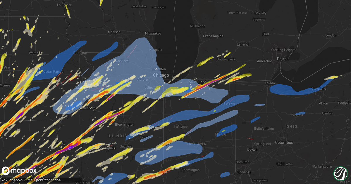
Hail Map on March 31, 2023
Get this storm
March 31 map
$229
one time, instant access
Download today. No call, no setup
Keep the $229
Bought the map and want the full workflow? Apply the entire $229 to a subscription within 7 days. None of it is wasted.
Every map, not just this one
This buys you this map. Subscription and you get every map we run, in the markets you choose from a few cities to whole states to nationwide. Plus real-time alerts the moment a storm fires.
Contact data
Name, contact info, occupancy, even credit band for addresses in the footprint. You go from where it hit to who to call.
Become the source they trust
Unlimited branding weather history reports on demand. You already have the documented answer ready for the property owner, and you are the one who showed up with it.
Property data and RoofTrace estimates
Pull up any address you have got, its value and the exact code rules for that jurisdiction, straight from One Click Code. Then RoofTrace estimates the squares, pitch, and roof value, priced the way you price.
States Impacted by Hail Map on March 31, 2023
Storm reports
Wisconsin
| Date | Description |
|---|---|
| 03/31/20236:56 PM CDT | A local report indicates 60 MPH wind near CUBA CITY |
| 03/31/20236:50 PM CDT | Reports of multiple trees down. |
| 03/31/20236:45 PM CDT | Reports of a farm shed down and powerlines down. |
| 03/31/20236:30 PM CDT | Sign damage noted. |
| 03/31/20236:17 PM CDT | Tree blown down across a road. |
| 03/31/20235:49 PM CDT | A local report indicates 1.25 inch wind near ARKDALE |
| 03/31/20235:47 PM CDT | A local report indicates 1.00 inch wind near 3 SSW BARRE MILLS |
| 03/30/20238:19 PM CDT | Reports of tornado on the ground near elkhorn. |
| 03/30/20238:10 PM CDT | Cambridge fire dept reported seeing a tornado with tree damage near the intersection of us hwy 12 and sleepy hollow road. Time est from radar. |
| 03/30/20238:01 PM CDT | Reports of damage to multiple buildings between sharon and delevan. |
| 03/30/20237:50 PM CDT | Delayed report. Time estimated via radar. A couple of downed trees and a fence gate... Which was closed and latched... Was taken off its hinges and thrown about 25 feet |
| 03/30/20237:46 PM CDT | Delayed report via social media of a collapsed garage. |
| 03/30/20237:26 PM CDT | Reports of multiple trees down and powerlines down across eastern and southeast green co. Time estimated from radar. |
| 03/30/20237:15 PM CDT | Roof damage to several structures near the intersection of county road h and willow bend road south of elkhorn. Time est from radar. |
| 03/30/20237:00 PM CDT | Structural damage reported near intersection of town hall road and koch road. Time est by radar. |
Kentucky
| Date | Description |
|---|---|
| 03/31/20233:48 AM CDT | A tree was reported to have been blown down in the abner mtn area along ky 122. The event time is radar estimated. |
| 03/31/20233:26 AM CDT | A tree was reported to have been blown down onto railroad tracks in vicco. The event time is radar estimate. |
| 03/31/20233:16 AM CDT | Large limbs were reported to have been blown down at a residence on polls creek in this vicinity. The event time is radar estimated. |
| 03/31/20231:55 AM CDT | A tree was reported to have been blown down in the duncan branch community along edwards mountain road. The event time is radar estimated. |
| 03/31/20231:52 AM CDT | A tree was blown down on slate branch road. The event time is radar estimated. |
| 03/31/20231:51 AM CDT | A powerline was blown down near the intersection of winding ridge road and oak hill road. The event time is radar estimated. |
| 03/31/20231:46 AM CDT | A tree was reported down along ky 761 with a couple of additional trees blown in the vicinity. The event time is radar estimated. |
| 03/31/20231:40 AM CDT | Huge tree down blocking the roadway... State route 207. |
| 03/31/202312:45 AM CDT | A local report indicates 61 MPH wind near 1 NE BROOKSVILLE |
| 03/31/202312:27 AM CDT | Delayed report. Thunderstorm wind damage was observed near robinson... Where a roof was blown off a barn. All debris from the roof was blown to the northeast corner of |
| 03/31/202312:23 AM CDT | Tree down over road. Time from radar |
| 03/31/202312:14 AM CDT | Delayed report. Dispatch reported tree and power line down on allen springs road. Report did not come in until closer to 6 am cdt... But radar imagery was used to estim |
| 03/30/202311:55 PM CDT | Via social media - images of a large tree blown onto a car on st. James court in louisville. |
| 03/30/202311:30 PM CDT | Delayed report. Large overhead garage doors blown out of facility. |
| 03/30/202311:28 PM CDT | Reported large healthy older maple tree was down... Blocking dorsey ln near ward ave. Power lines were down in this area too. Time estimated from radar data. |
| 03/30/202311:27 PM CDT | Klou reported a thunderstorm wind gust of 60 mph. |
| 03/30/202311:25 PM CDT | Retired nws employee reported an estimated wind gust near 60 mph. |
| 03/30/202311:00 PM CDT | Damage to the mixer restaurant in downtown hopkinsville. The the third story of the building collapsed. |
| 03/30/202311:00 PM CDT | Large tree down into power lines near perdue lane and s virginia st in hopkinsville. |
| 03/30/202310:49 PM CDT | *** 1 inj *** scattered large tree branches down. Several shallow-rooted trees uprooted. Two 2-story buildings downtown had windows blown out which caused the outer wal |
| 03/30/20239:41 PM CDT | Report from mping: quarter |
| 03/30/20239:40 PM CDT | Wind gusts estimated at 60mph in southwest murray. |
Pennsylvania
| Date | Description |
|---|---|
| 03/31/20233:00 AM CDT | Numerous trees and power lines down throughout the county. |
| 03/31/20232:45 AM CDT | Numerous trees and wires down throughout the county. |
Alabama
| Date | Description |
|---|---|
| 03/31/20235:34 AM CDT | Trees were blown down near tom cat road and beaird road. |
| 03/31/20235:27 AM CDT | Trees were blown down near colvin gap road and ford valley road. |
| 03/31/20234:53 AM CDT | Trees and powerlines down near alexander rd and patterson st. Possible tornado. |
| 03/31/20234:53 AM CDT | *** 2 inj *** trees and powerlines down near alexander rd and patterson st. Possible tornado. |
| 03/31/20233:17 AM CDT | A national weather service and lincoln county ema damage assessment team found evidence of an ef3 tornado in southeastern lincoln county. |
| 03/31/20233:10 AM CDT | *** 1 fatal... 5 inj *** corrects previous tornado report from 4 n hazel green. A national weather service and madison county ema damage assessment team found evidence |
| 03/31/20233:09 AM CDT | A tornado debris signature |
| 03/31/20232:47 AM CDT | Trees were blown down and blocking the roadway near countyline church road and milkweed road. Possible tornado. |
| 03/31/20232:47 AM CDT | Trees were blown down and blocking the roadway near countyline church road and milkweed road. Possible tornado. |
| 03/31/20232:47 AM CDT | Trees uprooted and power lines downed in haleyville. |
| 03/31/20232:44 AM CDT | *** 1 inj *** mobile home overturned on franks rd. Tds on radar. |
| 03/31/20232:44 AM CDT | Mobile home overturned on franks rd. Tds on radar. |
| 03/31/20232:35 AM CDT | Structural damage reported along hwy 253 near hackleburg. Tds on radar. |
| 03/31/20231:37 AM CDT | A tornado debris signature |
Oklahoma
| Date | Description |
|---|---|
| 03/31/20232:24 PM CDT | Quarter size hail reported near and just east of battiest. |
Michigan
| Date | Description |
|---|---|
| 03/31/20236:55 PM CDT | Up to ping pong size hail reported at the intersection of bogen road and south centreville street sw of sturgis. |
| 03/31/20236:55 PM CDT | Corrects previous hail report from 2 sw sturgis. Up to golf ball hail reported at the intersection of bogen road and south centreville street sw of sturgis. Spotter rep |
| 03/31/20236:30 PM CDT | A local report indicates 1.00 inch wind near STURGIS |
| 03/30/202311:56 PM CDT | Public measured 62 mph gust via personal weather station. |
| 03/30/202310:44 PM CDT | Trained spotter estimates wind gusts of 60 mph at olds rd and union city rd. |
| 03/30/202310:02 PM CDT | M-139 |
| 03/30/20238:04 PM CDT | One inch hail near pennfield. |
| 03/30/20237:19 PM CDT | A local report indicates 1.00 inch wind near ALAMO |
| 03/30/20237:00 PM CDT | A local report indicates 1.00 inch wind near STURGIS |
Tennessee
| Date | Description |
|---|---|
| 03/31/20236:30 PM CDT | One church was destroyed and several homes were damaged near the intersection of fulton road and evins road west of brownsville. |
| 03/31/20236:28 PM CDT | Corrects previous tornado report from brownsville. A roof was blown off a trailer on pepper lane in brownsville. Some debris is on the road and in the trees. |
| 03/31/20236:28 PM CDT | A roof was blown off a trailer on pepper lane in brownsville. Some debris is on the road and in the trees. |
| 03/31/20236:19 PM CDT | Mesonet station tt531 covington. |
| 03/31/20236:19 PM CDT | Mesonet station tt531 covington. |
| 03/31/20236:15 PM CDT | Roof damage and windows blown out at chevrolet dealarship on highway 51 south of downtown covington. |
| 03/31/20236:15 PM CDT | The covington hospital has been damaged with patients being rerouted to lauderdale county. |
| 03/31/20236:12 PM CDT | Power lines and trees down on highway 51 south of covington blocking the road. |
| 03/31/20236:00 PM CDT | Large trees down near akins store road and highway 51. |
| 03/31/202311:59 AM CDT | Quarter size hail via mping. |
| 03/31/20235:24 AM CDT | Trees down county wide... Including several in etowah... Tn. |
| 03/31/20235:23 AM CDT | Trees down county wide. |
| 03/31/20235:00 AM CDT | Powerlines down and damaged utility pole near seymour. |
| 03/31/20234:50 AM CDT | Powerlines down on mint road... Trees reported down in the county. |
| 03/31/20234:50 AM CDT | One tree down near the talbott area. |
| 03/31/20234:40 AM CDT | Hamilton county reports trees and lines down throughout county... Time estimated from radar. |
| 03/31/20233:35 AM CDT | Multiple trees down near pine ridge road... Railroad crossing gate blown over at the railroad tracks. |
| 03/31/20233:30 AM CDT | Numerous trees were blown down around knox county. |
| 03/31/20233:11 AM CDT | 1 tree down on road near spring city. |
| 03/31/20233:10 AM CDT | Several trees down. |
| 03/31/20232:55 AM CDT | Over 20 uprooted trees along cumberland lakes drive near monterey. Time is estimated based on radar. |
| 03/31/20232:51 AM CDT | *** tornado possible *** multiple homes damaged |
| 03/31/20232:50 AM CDT | A tree fell onto the corner of a house on old spencer road. |
| 03/31/20232:35 AM CDT | Power lines... Utility poles... And trees down near milk plant road. Multiple other trees down across western and northern white county. |
| 03/31/20232:30 AM CDT | Multiple trees down along liberty road and john mccoin road near sparta. |
| 03/31/20232:30 AM CDT | Two large oak trees uprooted along old state highway 111 about 6 miles away from fall creek falls state park southern entrance. |
| 03/31/20232:20 AM CDT | Damage reported east of smithville off of highway 70 included downed and uprooted trees... Roof damage... Siding peeled off a barn... And busted windows. Time estimated |
| 03/31/20232:09 AM CDT | Mesonet station av589 short mountain. |
| 03/31/20231:52 AM CDT | Twitter report of house on old woodbury pike lost part of roof... Garages... Patio... And several trees. |
| 03/31/20231:42 AM CDT | Trees down on multiple locations: elam rd... Bivens hill rd and 9951 john bragg hwy. |
| 03/31/20231:39 AM CDT | Tree reportedly fell through house on troupe road. |
| 03/31/20231:31 AM CDT | *** tornado possible *** house damage...800f roof is gone |
| 03/31/20231:25 AM CDT | Several trees down near 10800 block of bunker hill road in rockvale... Tn. |
| 03/31/20231:20 AM CDT | Twitter reports of five train cars overturned one half mile south of nashville hwy and thick road intersection. Possible tornado. |
| 03/31/20231:19 AM CDT | *** tornado possible *** power lines down... Carport and fencing mangled... Building debris in road on beasley rd near tennessee central rd |
| 03/31/20231:19 AM CDT | *** tornado possible *** power lines down... Carport and fencing mangled... Building debris in road on beasley rd near tennessee central rd |
| 03/31/20231:08 AM CDT | Twitter report w/ photo. |
| 03/31/202312:57 AM CDT | Large maple tree down on browns road east of lafayette. Time estimated based on radar. |
| 03/31/202312:55 AM CDT | Roof of home collapsed and trees down on rose lane. Possible tornado. |
| 03/31/202312:51 AM CDT | . |
| 03/31/202312:51 AM CDT | A local report indicates 1.00 inch wind near 4 SE LAFAYETTE |
| 03/31/202312:47 AM CDT | A local report indicates 1.25 inch wind near 2 SSW MILLEDGEVILLE |
| 03/31/202312:45 AM CDT | Hwy 10 and old lafayette rd. |
| 03/31/202312:45 AM CDT | Trees down in downtown hartsville at hayes st./rodgers st. |
| 03/31/202312:33 AM CDT | Quarter size hail via mping. |
| 03/31/202312:29 AM CDT | *** tornado possible *** houses with heavy damage in the 2100 block of buffalo rd. |
| 03/31/202312:29 AM CDT | Ping pong ball sized hail via mping. |
| 03/31/202312:20 AM CDT | *** tornado possible *** trees and lines down... Road impassible and heavy residential structural damage along james whitehead rd. In grinders creek. |
| 03/31/202312:18 AM CDT | Twitter report w/ photo. |
| 03/31/202312:16 AM CDT | Trees uprooted or snapped; roof blown off. |
| 03/30/202311:59 PM CDT | Corrects previous hail report from 5 sw ridgetop. Quarter size hail via mping. |
| 03/30/202311:53 PM CDT | Trees and power lines down along hwy 128 just south of bryant ln. |
| 03/30/202311:35 PM CDT | One house near adamsville had its roof torn off. |
| 03/30/202311:25 PM CDT | A local report indicates a tornado near 2 WSW PICKWICK DAM |
| 03/30/202311:22 PM CDT | Corrects previous tornado report from 4 sw bethel springs. Power lines knocked down and guardrails thrown in the road. Numerous trees are down close to sky blue lane. |
| 03/30/202311:22 PM CDT | Power lines knocked down and guardrails thrown in the road. |
| 03/30/202311:18 PM CDT | Trees uprooted or snapped; roof blown off. |
| 03/30/202310:19 PM CDT | Trees and power poles down at green hills estate and hwy 218. Time estimated by radar. |
| 03/30/20239:56 PM CDT | Trees down near the intersection of dowty road and peach street on the north side of selmer. |
| 03/30/20239:55 PM CDT | Large oak tree uprooted and fell on house. |
| 03/30/20239:40 PM CDT | A wall collapsed on a house on flowers road near bethel springs. |
| 03/30/20239:40 PM CDT | Reports of damage on buena vista road. |
| 03/30/20238:47 PM CDT | Report from mping: 3-inch tree limbs broken; power poles broken. |
Texas
| Date | Description |
|---|---|
| 03/31/20236:58 PM CDT | Nickel to quarter size hail in crockett. |
| 03/31/20236:51 PM CDT | A local report indicates 1.75 inch wind near 1 ENE TENAHA |
| 03/31/20236:06 PM CDT | Reports of trees down just east of laneville near fm road 2496 at county road 3162... Fm road 2496 near fm road 1798... And along county road 3163. |
| 03/31/20235:26 PM CDT | Quarter size hail measured in the maydelle community. |
| 03/31/20235:20 PM CDT | Trees down on hendricks lake rd and north hill st. |
| 03/31/20234:25 PM CDT | Tree limbs down near grove club lake just south of whitehouse texas. |
| 03/31/20234:07 PM CDT | Tree damage and tree limbs down in the copeland road and paluxy drive areas in south tyler. |
| 03/31/20233:30 PM CDT | Photo of ping pong size hail north of mount pleasant near the intersection of county road 3265 and county road 3250. |
| 03/31/20233:28 PM CDT | Social media post of hail near golf ball size north of mount pleasant texas. |
| 03/30/20237:15 PM CDT | Social media photos of hail at least 2 inches or larger just south of joaquin. |
| 03/30/20237:08 PM CDT | Social media photo of ping pong size hail near joaquin from ksla tv. |
| 03/30/20237:05 PM CDT | Quarter size hail in berea. |
Arkansas
| Date | Description |
|---|---|
| 03/31/20236:59 PM CDT | Spotter report of a tornado. |
| 03/31/20236:22 PM CDT | Golf ball size hail reported 3 miles west of casscoe... Ar. |
| 03/31/20235:34 PM CDT | Power poles broken at intersection of hwy 61 and hwy 325. Time estimated from radar. |
| 03/31/20235:27 PM CDT | Report of golf ball sized hail in sheridan... Ar. |
| 03/31/20235:26 PM CDT | Quarter size hail reported in the genoa area. |
| 03/31/20235:25 PM CDT | Truck overturned as tornado cross i-55. |
| 03/31/20235:10 PM CDT | Reports of damage just east of country road near wynne. |
| 03/31/20235:05 PM CDT | Report from mping: homes/buildings completely destroyed. |
| 03/31/20235:01 PM CDT | Mesonet station up525 5.9 w parkin |
| 03/31/20235:00 PM CDT | Report from mping: homes/buildings completely destroyed. |
| 03/31/20234:45 PM CDT | City of wynne has had damage all over town including wynne high school. Dozens of people are believed to be trapped. |
| 03/31/20234:43 PM CDT | Unconfirmed tornado on ground 2 mi west of wynne. |
| 03/31/20234:38 PM CDT | Unconfirmed report of tornado ar 284-193 w of wynne by trained spotter. |
| 03/31/20233:55 PM CDT | Em sent photo of ping pong size hail from the public in blevins... Arkansas. |
| 03/31/20233:51 PM CDT | Several photos from social media of hail near 2 inches in mccaskill... Arkansas. |
| 03/31/20233:42 PM CDT | Reports of hail up to golf ball size caused dents and cracked windshield near the columbus arkansas community. |
| 03/31/20233:40 PM CDT | Social media photo of hail up to ping pong size near the town of ozan arkansas. |
| 03/31/20233:06 PM CDT | House destroyed in cammack village. |
| 03/31/20233:02 PM CDT | Police station damaged and keihl street is blocked. |
| 03/31/20233:00 PM CDT | Damage to homes and buisnesses off highway 89 in cabot. |
| 03/31/20232:48 PM CDT | Debris reported off dakota street. |
| 03/31/20232:27 PM CDT | Trees down along with damaged and destroyed homes at pontiac and osage in north little rock. |
| 03/31/20232:25 PM CDT | Significant damage to bowman curve and mara lynn apartments. |
| 03/31/20232:23 PM CDT | Homes at oak ridge were reported as destroyed. |
| 03/31/20232:18 PM CDT | This was a high end ef3 tornado with maximum wind speeds of 165 mph. |
| 03/31/20232:15 PM CDT | Damage to homes in leawood neighborhood in midtown. |
| 03/31/20232:15 PM CDT | Major damage to home off youngwood road. |
Indiana
| Date | Description |
|---|---|
| 03/31/20236:52 PM CDT | A local report indicates 1.25 inch wind near 1 WSW CLEAR LAKE |
| 03/31/20236:50 PM CDT | Report via facebook. |
| 03/31/20236:42 PM CDT | Quarter size hail reported at the intersection of cr 16 and cr 43. Time estimated from radar. |
| 03/31/20236:40 PM CDT | Corrects time of previous hail report from shipshewana. Time estimated from radar. Report from facebook. |
| 03/31/20236:40 PM CDT | A local report indicates 1.25 inch wind near MIDDLEBURY |
| 03/31/20236:33 PM CDT | At the intersection of county road 20 and sr 15. |
| 03/31/20236:26 PM CDT | Quarter size hail reported at the intersection of county road 6 and us-19. |
| 03/31/20236:03 PM CDT | Quarter size hail reported near the intersection of church street and michigan road. |
| 03/31/20236:00 PM CDT | Ping pong ball sized hail reported. Time estimated from radar. |
| 03/31/20236:00 PM CDT | Ping pong size hail reported. Time estimated from radar. |
| 03/31/20235:45 PM CDT | Time estimated from radar. Report from facebook. |
| 03/31/20235:35 PM CDT | A local report indicates 1.25 inch wind near 3 E WANATAH |
| 03/31/20235:35 PM CDT | Corrects previous hail report from gulivoire park. Photo on twitter of hail on the south side of south bend. Estimated up to 2 inch sized hail. Time estimated from rada |
| 03/31/20235:35 PM CDT | Photo on twitter of hail on the south side of south bend. Estimated quarter size hail. Time estimated from radar. |
| 03/31/20235:30 PM CDT | Photo on twitter of severe hail in lakeville... In. Time estimated from radar. Ping pong sized hail. |
| 03/31/20235:30 PM CDT | Photo on twitter of estimated golf ball sized hail at laville high school in lakeville... In. Several vehicles have damage. Time estimated from radar. |
| 03/31/20235:18 PM CDT | Corrects time of previous hail report from walkerton. Ping pong size hail reported. Time estimated from radar. |
| 03/31/20235:05 PM CDT | A local report indicates 1.00 inch wind near KINGSFORD HEIGHTS |
| 03/31/20234:58 PM CDT | Corrects time of previous hail report from 3 e wanatah. |
| 03/31/20234:58 PM CDT | A local report indicates 1.00 inch wind near WANATAH |
| 03/31/20234:56 PM CDT | A local report indicates 1.00 inch wind near 1 NNW VALPARAISO |
| 03/31/20234:55 PM CDT | Photo shared of hail in valparaiso with the largest hailstones being approximately quarter sized. |
| 03/31/20234:54 PM CDT | A local report indicates 1.00 inch wind near LAKES OF THE FOUR SEASO |
| 03/30/202311:40 PM CDT | Multiple trees down in the county. |
| 03/30/202311:22 PM CDT | Several large trees reported down. Time from radar |
| 03/30/202311:16 PM CDT | Several large trees reported down. Time from radar |
| 03/30/202311:15 PM CDT | Multiple reports of damage throughout jay county. |
| 03/30/202311:13 PM CDT | A local report indicates 62 MPH wind near VERSAILLES |
| 03/30/202311:06 PM CDT | Tree down at intersection of sr 129 and sr 350. Time from radar |
| 03/30/202311:05 PM CDT | A local report indicates 1.00 inch wind near ALBANY |
| 03/30/202311:00 PM CDT | Smith field airport awos. |
| 03/30/202311:00 PM CDT | Barn roof blown off. Roof of house also partially blown off. |
| 03/30/202311:00 PM CDT | Limbs and powerlines downed. |
| 03/30/202311:00 PM CDT | A local report indicates 60 MPH wind near 2 E BLUFFTON |
| 03/30/202311:00 PM CDT | Power flashes. 5 miles north of montpelier looking se at 12:00 am. Video on twitter. |
| 03/30/202310:55 PM CDT | A local report indicates 68 MPH wind near 2 N KENDALLVILLE |
| 03/30/202310:55 PM CDT | Asos station kgez shelbyville. |
| 03/30/202310:55 PM CDT | Thunderstorm winds downed gas station overhanging roof. Time estimated. |
| 03/30/202310:54 PM CDT | A local report indicates 67 MPH wind near 1 WSW LAKE JAMES |
| 03/30/202310:50 PM CDT | Winds at onset of thunderstorm. Reports of numerous power poles and lines down across madison county. Time estimated. |
| 03/30/202310:45 PM CDT | Large tree downed. |
| 03/30/202310:40 PM CDT | Numerous reports of large trees and powerlines downed. Also received a report of vehicles blown off road. |
| 03/30/202310:40 PM CDT | A local report indicates 65 MPH wind near 3 E AVON |
| 03/30/202310:36 PM CDT | A local report indicates 67 MPH wind near INDIANAPOLIS INTL AIRP |
| 03/30/202310:36 PM CDT | A local report indicates 67 MPH wind near INDIANAPOLIS INT'L AIRP |
| 03/30/202310:35 PM CDT | Damage to several buildings. |
| 03/30/202310:34 PM CDT | Asos station keye indianapolis |
| 03/30/202310:33 PM CDT | Thunderstorm winds consistent with probable tornado destroyed multiple homes on both sides of us highway 31 with warehouse damage. Time estimated. |
| 03/30/202310:31 PM CDT | A local report indicates 68 MPH wind near 2 ENE NINE MILE |
| 03/30/202310:30 PM CDT | Mesonet station pdu05 northeast purdue agricultural ce. |
| 03/30/202310:30 PM CDT | 5 semis blown over. Damage to commercial structure. Tree on home on nearby doty rd. Vehicles blown into yard. |
| 03/30/202310:30 PM CDT | A local report indicates 62 MPH wind near 3 NNE FORT WAYNE |
| 03/30/202310:29 PM CDT | Privacy fence destroyed and window broken. |
| 03/30/202310:25 PM CDT | Damage to several buildings. |
| 03/30/202310:25 PM CDT | Thunderstorm winds partially collapsed 2 homes and downed trees at county roads 400 west and 300 south. Building collapsed at 750 west and 5145 south. Possible funnel c |
| 03/30/202310:25 PM CDT | 2 homes partially collapsed and trees down at county roads 400 west and 300 south. Building collapsed at county roads 750 west and 5145 south. Possible funnel cloud at |
| 03/30/202310:23 PM CDT | Winds downed multiple trees with considerable home damage between martinsville and paragon. Also estimated 60 mph winds in paragon. |
| 03/30/202310:23 PM CDT | Winds downed multiple trees with considerable home damage between martinsville and par |
| 03/30/202310:23 PM CDT | Thunderstorm winds downed numerous large trees and snapped power poles. Time estimated. |
| 03/30/202310:20 PM CDT | Report on twitter of a barn fire ongoing at 16000 osborne road as of 11:20 pm et. Unsure of cause. |
| 03/30/202310:20 PM CDT | *** 1 inj *** tornado began here traveling 6.41 miles ne ending se of greentown. Maximum width of tornado was 25 yards. |
| 03/30/202310:19 PM CDT | Measured gust 64 mph. |
| 03/30/202310:18 PM CDT | Several trees downed across southern part of county. |
| 03/30/202310:17 PM CDT | Several reports of power flashes observed near benton. Power outages reported as well. |
| 03/30/202310:15 PM CDT | Brief tornado east of russiaville. Total length of 0.14 miles and a maximum width of 10 yards. |
| 03/30/202310:12 PM CDT | 2 ft diameter tree downed. Powerlines downed and train railcars flipped over. |
| 03/30/202310:11 PM CDT | A local report indicates 1.00 inch wind near ANDREWS |
| 03/30/202310:11 PM CDT | Tornado began here... Ending 0.86 miles away sw of russiaville. Max tornado width was 10 yards. |
| 03/30/202310:10 PM CDT | Metal barn partially destroyed with pieces of metal thrown into nearby trees. |
| 03/30/202310:10 PM CDT | Severe winds lasted 8 minutes 1110pm to 1118pm. 3 trees down. Dime hail. |
| 03/30/20239:55 PM CDT | Tree across road. |
| 03/30/20239:54 PM CDT | Tree across road. No information on health of tree. |
| 03/30/20239:53 PM CDT | Pea sized hail also reported. |
| 03/30/20239:50 PM CDT | Reports of building collapse in north liberty. A building on n main street that suffered damage from a fire back in february was further damaged by strong winds friday |
| 03/30/20239:50 PM CDT | Multiple trees uprooted to the east. Roof damaged with north facing singles ripped of and then blown south and then from east to west on the ground. Observed and record |
| 03/30/20239:49 PM CDT | Tree down. |
| 03/30/20239:49 PM CDT | A local report indicates 60 MPH wind near PERU |
| 03/30/20239:48 PM CDT | Jaworskis market... 58413 crumstown hwy south bend... In 46619. Sign blown over from wind gusts... Friday evening. Photo on twitter. Time estimated from radar. |
| 03/30/20239:45 PM CDT | Barn destroyed. Time estimated via radar. |
| 03/30/20239:45 PM CDT | Estimated on east side of evansville. |
| 03/30/20239:45 PM CDT | Johnston road west of crumstown highway... Road blocked due to downed tree. Time estimated from radar. |
| 03/30/20239:45 PM CDT | Tree across road. Time estimated from radar. |
| 03/30/20239:45 PM CDT | Large tree branches down and debris as well... Blocking crumstown trail road near north liberty... In. Time estimated from radar. |
| 03/30/20239:45 PM CDT | Tree across road. Time estimated from radar. |
| 03/30/20239:45 PM CDT | Tornado began at this point ending sw of frankfort for a total distance of 6.79 miles. The max width of the tornado was 100 yards. |
| 03/30/20239:41 PM CDT | Thunderstorm winds snapped tops off of 20 trees and blew roof of of barn. |
| 03/30/20239:40 PM CDT | A local report indicates 1.00 inch wind near 2 S DARLINGTON |
| 03/30/20239:35 PM CDT | Large tree snapped laing ave. |
| 03/30/20239:35 PM CDT | Observed at kcfj awos. |
| 03/30/20239:35 PM CDT | Awos station kppo la porte. |
| 03/30/20239:30 PM CDT | Thunderstorm winds flattened 2 structures to basement. Several other structures with roofs blown off near junction of benton tippecanoe and white counties. 1 inch hail |
| 03/30/20239:24 PM CDT | *** 2 fatal... 1 inj *** thunderstorm winds consistent with probable tornado. 2 fatalities and 1 injury and 1 person missing. Time estimated. |
| 03/30/20239:22 PM CDT | Power poles also downed in the demotte area. |
| 03/30/20239:21 PM CDT | *** 7 inj *** tree onto van. Preliminary report of 7 injuries... 5 minor. |
| 03/30/20239:20 PM CDT | Several homes damaged at 875w and 400n. |
| 03/30/20239:20 PM CDT | Semi blown over on sr 16 at 1050w. |
| 03/30/20239:20 PM CDT | Trees downed east-northeast of fair oaks. Time estimated from radar. |
| 03/30/20239:19 PM CDT | Tree downed onto road. Time estimated from radar. |
| 03/30/20239:13 PM CDT | Corrects previous tstm wnd dmg report from 1 wsw crumstown. Tree down. Corrected time. |
| 03/30/20239:11 PM CDT | 65 kt gust at kvpz. |
| 03/30/20239:10 PM CDT | Several trees and power lines downed across the north side of valparaiso. |
| 03/30/20239:07 PM CDT | 76th and jackson st area. 6-7 homes with roofs peeled off over garages. Debris scattered and wrapped around trees and poles... And trees down. Potential tornado damage. |
| 03/30/20239:05 PM CDT | 62 mph wind gust recorded in round grove... In. Building collapsed. |
| 03/30/20239:05 PM CDT | Multiple power lines down in an area around cates to kingman. |
| 03/30/20239:01 PM CDT | 129th and delaware sustained winds 50-55 mph e 65-70 gusts. |
| 03/30/20238:57 PM CDT | Large tree downed. |
| 03/30/20238:57 PM CDT | Report from mping: trees uprooted or snapped. |
| 03/30/20238:56 PM CDT | Shingles and sheathing removed from garage. Numerous trees damaged... Some large trees downed. |
| 03/30/20238:56 PM CDT | A few smaller tree limbs downed and a few shingles blown off a roof. |
| 03/30/20238:56 PM CDT | Several instances of tree damage reported in crown point. Fences also blown down. |
| 03/30/20238:55 PM CDT | Two homes destroyed and damage to several others. |
| 03/30/20238:55 PM CDT | 2 homes destroyed and several damaged. |
| 03/30/20238:54 PM CDT | Penny size hail also. |
| 03/30/20238:53 PM CDT | Measured on personal weather station. |
| 03/30/20238:53 PM CDT | Photo of 5 power poles either snapped or leaning due to wind. |
| 03/30/20238:50 PM CDT | Structural damage reported at fbi buildings inc. Time estimated based on radar. |
| 03/30/20238:50 PM CDT | Spotter reports vehicles blown over and damage in the median along i-65 mile markers 187-190... Near sr-18 exit. |
| 03/30/20238:49 PM CDT | Reports of 6 semis flipped at southbound exit 201 on i-65. Time estimated based on radar. |
| 03/30/20238:38 PM CDT | Reports of numerous structures damaged along county road e 330 s from near atkinson east to the county line. Corner of 2nd floor and nearly entire roof of new construct |
| 03/30/20238:36 PM CDT | A local report indicates 1.00 inch wind near 4 W RAINSVILLE |
| 03/30/20237:00 PM CDT | A local report indicates 1.00 inch wind near CLEAR LAKE |
Mississippi
| Date | Description |
|---|---|
| 03/31/20235:30 PM CDT | Damage to several homes on verner road. |
| 03/31/20231:42 AM CDT | Report from mping: trees uprooted or snapped; roof blown off. |
| 03/31/20231:27 AM CDT | Part of roof torn off of cooper tire. |
| 03/31/20231:20 AM CDT | 1-inch tree limbs broken; shingles blown off. |
| 03/31/20231:10 AM CDT | Several homes were damaged in the 10th street area of pontotoc. Trees were blown down and power poles were damaged. |
| 03/31/20231:03 AM CDT | Trees uprooted or snapped; roof blown off. |
| 03/30/20238:15 PM CDT | Possible tornado. |
| 03/30/20238:10 PM CDT | Some roof damage and trees down near the intersection of highway 304 and scenic lane. |
| 03/30/20237:55 PM CDT | Dozens of trees downed and an outdoor storage structure destroyed. |
| 03/30/20237:54 PM CDT | Report of damage on arklabutla dam road in tunica county. |
| 03/30/20237:52 PM CDT | Several trees were knocked down with one tree on a car on horn lake road north of dean road. |
Georgia
| Date | Description |
|---|---|
| 03/31/20236:50 AM CDT | Trees down at henry grady hwy and price rd. |
| 03/31/20236:43 AM CDT | Trees down at hickory flat hwy and charles cox dr. |
| 03/31/20236:40 AM CDT | Wooden roof blown off of a baseball dugout... Bleachers were blown over... And a wooden light pole was snapped at south cherokee park. |
| 03/31/20236:38 AM CDT | Trees down along hightower road. |
| 03/31/20236:37 AM CDT | Signs down... Traffic lights damaged... Gdot webcam was taken out... And a car hood/front bumper were reported to be taken off on the ridgewalk pkwy bridge over 575. |
| 03/31/20236:37 AM CDT | Small trees snapped in half at olde rope mill park rd and ridgewalk pkwy. |
| 03/31/20236:35 AM CDT | Tornado confirmed on dream catcher dr. Two trees snapped. Ef rating and path currently being assessed. |
| 03/31/20236:32 AM CDT | Trees down at epperson rd and scott rd. |
| 03/31/20236:28 AM CDT | Trees down across railroad on railroad ave near mineral bluff hwy. |
| 03/31/20236:25 AM CDT | Tree down along sugar creek rd. |
| 03/31/20236:25 AM CDT | Trees and powerlines down at refuge valley rd and waleska 108. |
| 03/31/20236:23 AM CDT | Trees down at lower burris rd and land rd. |
| 03/31/20236:23 AM CDT | Trees down at sutallee ridge trace and white road. |
| 03/31/20236:11 AM CDT | Quarter sized hail reported on east valley rd. |
| 03/31/20236:05 AM CDT | Tree down blocking the road on timberwood rd near crowe springs spur nw. |
| 03/31/20236:05 AM CDT | Trees down at spring place rd and hwy 140. |
| 03/31/20236:03 AM CDT | Trees down at cagle rd and hwy 411. |
| 03/31/20236:03 AM CDT | Trees down at pinhook rd and hwy 411. |
| 03/31/20236:02 AM CDT | Trees down at orr mill rd and hwy 411. |
| 03/31/20236:00 AM CDT | Tree down along springdale rd. |
| 03/31/20235:59 AM CDT | Quarter sized hail reported near plainview rd and erwin hill rd. |
| 03/31/202312:33 AM CDT | Tree down on cannon rd near milepond rd. |
Louisiana
| Date | Description |
|---|---|
| 03/30/202311:36 PM CDT | A couple of trees were downed on highway 15 |
| 03/30/202311:25 PM CDT | Corrects previous tstm wnd dmg report from 6 sw brownsville-bawcom. A picture was posted to social media of a large limb that broke through a kitchen window of a home o |
| 03/30/202311:25 PM CDT | Corrects previous tstm wnd dmg report from 6 sw claiborne. A tree was downed onto a home on williams harris road in west monroe. |
| 03/30/202311:15 PM CDT | Trees and power lines were downed in the cartwright community. |
| 03/30/202311:10 PM CDT | Trees and power lines were downed near the jackson/lincoln parish line south of choudrant. |
| 03/30/202310:58 PM CDT | A picture was posted to social media of quarter size hail that covered the ground in quitman. |
| 03/30/202310:54 PM CDT | Trees and power lines were downed in quitman. |
| 03/30/202310:54 PM CDT | Sheriff department reports many trees down in the quitman area. |
| 03/30/202310:26 PM CDT | Reports of extensive wind damage to trees and powerlines across bienville parish... With the sheriff department receiving several reports between the town of castor and |
| 03/30/202310:25 PM CDT | A picture was posted to social media of a large limb that broke through a kitchen window of a home on caples road in west monroe. |
| 03/30/202310:25 PM CDT | A tree was downed onto a home on williams harris road in west monroe. |
Ohio
| Date | Description |
|---|---|
| 03/31/20232:01 AM CDT | Tree snapped at the base. |
| 03/31/20232:00 AM CDT | C-man station faio1 fairport... Oh measured a 51 kt marine thunderstorm wind gust. |
| 03/31/20231:57 AM CDT | Weather station in se parma reported a 54 kt thunderstorm wind gust. |
| 03/31/20231:54 AM CDT | Large tree down. |
| 03/31/20231:46 AM CDT | Corrects previous tstm wnd gst report from 2 sse parma. Weather station in se parma reported a 54 kt thunderstorm wind gust. Corrected for time. |
| 03/31/20231:45 AM CDT | Tree into power lines. |
| 03/31/20231:41 AM CDT | Asos station kbkl cleveland measured a 61 kt thunderstorm wind gust. |
| 03/31/20231:41 AM CDT | Asos station kbkl cleveland measured a 61 kt marine thunderstorm wind gust. |
| 03/31/20231:35 AM CDT | Tree reported down on state route 671 between us 50 and the ross county line. Time estimated from radar. |
| 03/31/20231:30 AM CDT | Ashland county sheriff dispatch reports large trees down near ashland... Oh. |
| 03/31/20231:22 AM CDT | Asos station klpr lorain elyria measured a 61 kt thunderstorm wind gust. |
| 03/31/20231:20 AM CDT | Richland county sheriffs dispatch reports multiple power lines and trees down. Also reports that half of a roof was blown off building and damage to porches of homes. |
| 03/31/20231:18 AM CDT | Trees topped off and blown over. Power poles down. Roof blown off madison township hall. |
| 03/31/20231:17 AM CDT | Tree down over road. Time from radar |
| 03/31/20231:15 AM CDT | Morrow county sheriffs dispatch reports trees down near route 42 in mount gilead. |
| 03/31/20231:05 AM CDT | Report from mping: 3-inch tree limbs broken; power poles broken. |
| 03/31/20231:05 AM CDT | The top third of a white pine tree was snapped off. |
| 03/31/202312:55 AM CDT | Crawford county oh sheriffs dispatch reports damage to a barn in holmes township. |
| 03/31/202312:54 AM CDT | Roof of barn blown onto railroad tracks and caused train engine to derail. Hay barn destroyed and toppled stacked rolls of hay. Trees snapped off and toppled. |
| 03/31/202312:51 AM CDT | Trees down and road signs bent. |
| 03/31/202312:50 AM CDT | Recorded at nws office wilmington. |
| 03/31/202312:43 AM CDT | Tree down over road. Time from radar |
| 03/31/202312:40 AM CDT | Marion county sheriffs dispatch reports power line down near la rue... Oh. |
| 03/31/202312:40 AM CDT | Wyandot county emergency manager reports multiple trees and power lines down in upper sandusky... Oh. |
| 03/31/202312:39 AM CDT | Large pine tree down |
| 03/31/202312:38 AM CDT | Report of 1 house sustaining damage and a barn roof blown off near the intersection of warpole and west walker streets. |
| 03/31/202312:37 AM CDT | Multiple structures with damage on site. |
| 03/31/202312:33 AM CDT | Pine trees snapped and damage to a roof |
| 03/31/202312:21 AM CDT | Barn destroyed and multiple trees down. |
| 03/31/202312:20 AM CDT | Hancock county sheriff dispatch reports multiple trees and power lines down. |
| 03/31/202312:17 AM CDT | A local report indicates 69 MPH wind near KDAY DAYTON COX APT |
| 03/31/202312:13 AM CDT | Small trees down... Barn and fence destroyed. |
| 03/31/202312:11 AM CDT | Ottawa county sheriff dispatch reports trees and power lines down across the western portion of the county. A personal weather station reported a 78.7 mph wind gust in |
| 03/31/202312:10 AM CDT | A few trees were downed. |
| 03/31/202312:10 AM CDT | Tree down. Time from radar |
| 03/31/202312:10 AM CDT | Tree down over road. Time from radar |
| 03/31/202312:10 AM CDT | 6 inch diameter tree down. Time from radar |
| 03/31/202312:09 AM CDT | Power pole snapped in half. Time from radar |
| 03/31/202312:09 AM CDT | Large tree down. Time from radar |
| 03/31/202312:09 AM CDT | Damage to hog barn along with a few power lines down. Time estimated from radar. |
| 03/31/202312:07 AM CDT | Large tree branches downed. Time estimated from radar. |
| 03/31/202312:05 AM CDT | Significant damage to a shed and a carport lifted off ground. |
| 03/31/202312:04 AM CDT | Minor roof damage to a house and an outbuilding was damaged. A barn wall was also blown in. |
| 03/31/202312:04 AM CDT | Roof blown off barn. Lots of damage to multiple properties as well. |
| 03/31/202312:03 AM CDT | Signicant property damage with fire department response on scene. |
| 03/31/202312:03 AM CDT | 3 trees down including one through bedroom window. Likely tornado. |
| 03/31/202312:03 AM CDT | Barn roof blown in and power poles snapped. |
| 03/31/202312:02 AM CDT | Some large tree branches down and some structural damage to a barn. |
| 03/31/202312:00 AM CDT | Several grain bins torn down... Medium sized brick building partially torn down. |
| 03/31/202312:00 AM CDT | Trees down and barn damage |
| 03/31/202312:00 AM CDT | Three trees downed along with a few powerlines. |
| 03/30/202311:55 PM CDT | A local report indicates 65 MPH wind near 3 WNW GILBOA |
| 03/30/202311:54 PM CDT | Roof damage... Tree damage... And barn damage. |
| 03/30/202311:50 PM CDT | Multiple power poles and trees down. Barn collapsed. |
| 03/30/202311:50 PM CDT | Shingles torn off roof. |
| 03/30/202311:49 PM CDT | Roof damage... Trees down... Grain bin in yard from a mile away. Possible tornado. |
| 03/30/202311:47 PM CDT | Roof off building... Garage doors blown in... Power poles snapped |
| 03/30/202311:46 PM CDT | Report of damage to multiple barns... Debris in field. Time est from radar. |
| 03/30/202311:46 PM CDT | Report of damage to multiple barns... Debris in field. Time est from radar. |
| 03/30/202311:45 PM CDT | Wood county sheriff dispatch reports multiple wires down near weston. |
| 03/30/202311:35 PM CDT | Lucas county sheriff dispatch reports multiple trees and power lines down. Reports that a tree fell onto a house north of maumee... Oh. |
| 03/30/202311:35 PM CDT | Tree and power pole reported down at park road west of sr 49 |
| 03/30/202311:31 PM CDT | Several animal barns damaged near park road and fort recovery. Time front radar |
| 03/30/202311:30 PM CDT | Semi blown over. |
| 03/30/202311:30 PM CDT | 2 large trees downed. |
| 03/30/202311:30 PM CDT | Semi blown over. |
| 03/30/202311:23 PM CDT | Amatuer radio reports town of ney has no power. |
| 03/30/202310:31 PM CDT | A local report indicates 59 MPH wind near 3 NW BRUNERSBURG |
| 03/30/20239:57 PM CDT | A local report indicates 1.25 inch wind near 3 E NORTH MADISON |
| 03/30/20239:42 PM CDT | Report from mping: half dollar |
Colorado
| Date | Description |
|---|---|
| 03/31/20233:45 PM CDT | Report from mping: 1-inch tree limbs broken. |
| 03/31/20233:31 PM CDT | Report from mping: 1-inch tree limbs broken. |
Missouri
| Date | Description |
|---|---|
| 03/31/20236:59 PM CDT | Tree snapped at base that caused power lines down. |
| 03/31/20236:32 PM CDT | Delayed report. |
| 03/31/20236:31 PM CDT | A local report indicates 1.00 inch wind near 2 ESE HEMATITE |
| 03/31/20236:27 PM CDT | Spotter was south of exit 175 off of i-55 and estimated winds approached 60 mph. |
| 03/31/20236:20 PM CDT | A local report indicates 1.00 inch wind near 2 ESE DE SOTO |
| 03/31/20236:19 PM CDT | Delayed report. |
| 03/31/20236:19 PM CDT | Delayed report... Time estimated from radar. |
| 03/31/20236:18 PM CDT | A local report indicates 1.75 inch wind near LADDONIA |
| 03/31/20236:18 PM CDT | Report from mping: golf ball |
| 03/31/20236:10 PM CDT | Delayed report... Time estimated from radar. |
| 03/31/20235:25 PM CDT | A local report indicates 1.00 inch wind near TROY |
| 03/31/20235:24 PM CDT | Mtn view pd howell co reports wind damage... Trees down... Structural damage. |
| 03/31/20235:20 PM CDT | Light damage to buildings... Signs blown down... And 3-8 inch tree limbs down. Estimate near 70-80 mph winds. |
| 03/31/20235:16 PM CDT | Also reported rotating wall cloud. |
| 03/31/20235:15 PM CDT | Spotter called back with an update out of sullivan. Largest hail the spotter observed was slightly larger than a quarter. Time estimated by radar. |
| 03/31/20235:10 PM CDT | Delayed report via social media. |
| 03/31/20235:05 PM CDT | Delayed report received via social media. |
| 03/31/20234:55 PM CDT | Delayed report: a mixture of dime and quarter size hail in northern phelps county. Time estimated via radar. |
| 03/31/20234:55 PM CDT | Delayed report of a couple of trees down on county road 1050 in northern phelps county with the thunderstorm. |
| 03/31/20234:48 PM CDT | Initially pea sized hail at 4:15. Quarter size at 4:48 pm. Final time estimated from radar. |
| 03/31/20234:45 PM CDT | Delayed report. |
| 03/31/20234:30 PM CDT | A local report indicates 1.50 inch wind near VANDALIA |
| 03/31/20234:25 PM CDT | Mping report... Time estimated from radar. |
| 03/31/20234:21 PM CDT | A local report indicates 1.25 inch wind near 1 E LADDONIA |
| 03/31/20234:20 PM CDT | Report from mping: golf ball |
| 03/31/20234:19 PM CDT | Time estimated from radar. |
| 03/31/20234:17 PM CDT | Reported by county dispatch. |
| 03/31/20234:16 PM CDT | Report from mping: ping pong ball |
| 03/31/20234:15 PM CDT | Delayed report. |
| 03/31/20234:15 PM CDT | A local report indicates 2.00 inch wind near 1 SW HANNIBAL |
| 03/31/20234:13 PM CDT | A local report indicates 1.00 inch wind near 3 WSW BENTON CITY |
| 03/31/20234:11 PM CDT | Up to golf ball sized hail... Ended at the time of the call. Very heavy rain falling now. |
| 03/31/20234:10 PM CDT | Delayed report. |
| 03/31/20234:09 PM CDT | A local report indicates 2.00 inch wind near 2 SW HANNIBAL |
| 03/31/20234:08 PM CDT | A local report indicates 1.75 inch wind near 2 SW RUSH HILL |
| 03/31/20234:08 PM CDT | A local report indicates 1.50 inch wind near 2 ENE VANDIVER |
| 03/31/20234:07 PM CDT | A local report indicates 1.25 inch wind near 2 SSE HANNIBAL |
| 03/31/20234:06 PM CDT | A local report indicates 1.75 inch wind near HANNIBAL |
| 03/31/20234:06 PM CDT | Report from mping: quarter |
| 03/31/20234:06 PM CDT | A local report indicates 1.25 inch wind near 1 S HANNIBAL |
| 03/31/20234:05 PM CDT | A local report indicates 1.75 inch wind near 1 WNW MEXICO |
| 03/31/20234:05 PM CDT | A local report indicates 1.00 inch wind near 1 WSW MEXICO |
| 03/31/20234:05 PM CDT | A local report indicates 2.50 inch wind near HANNIBAL |
| 03/31/20234:05 PM CDT | A local report indicates 1.75 inch wind near 1 E HANNIBAL |
| 03/31/20234:05 PM CDT | A local report indicates 1.50 inch wind near 3 W AUXVASSE |
| 03/31/20234:05 PM CDT | Hail getting bigger. |
| 03/31/20234:04 PM CDT | A local report indicates 1.75 inch wind near 5 NW NEW HARTFORD |
| 03/31/20234:04 PM CDT | A local report indicates 1.25 inch wind near HANNIBAL |
| 03/31/20234:03 PM CDT | A local report indicates 1.50 inch wind near HANNIBAL |
| 03/31/20234:03 PM CDT | A local report indicates 1.00 inch wind near 1 WSW MEXICO |
| 03/31/20234:03 PM CDT | A local report indicates 1.00 inch wind near HANNIBAL |
| 03/31/20234:02 PM CDT | Report from mping: quarter |
| 03/31/20234:02 PM CDT | Report from mping: quarter |
| 03/31/20234:01 PM CDT | Report from mping: golf ball |
| 03/31/20234:01 PM CDT | A local report indicates 1.75 inch wind near HANNIBAL |
| 03/31/20234:00 PM CDT | A local report indicates 1.00 inch wind near 1 NW MEXICO |
| 03/31/20234:00 PM CDT | Time estimated from radar. |
| 03/31/20234:00 PM CDT | A local report indicates 1.50 inch wind near 2 ESE HANNIBAL |
| 03/31/20233:59 PM CDT | Report from mping: ping pong ball |
| 03/31/20233:59 PM CDT | House was being heavily damaged by baseball size hail. |
| 03/31/20233:58 PM CDT | Report from mping: quarter |
| 03/31/20233:57 PM CDT | Tree down. Report via 911 center. |
| 03/31/20233:48 PM CDT | Report from south columbia. |
| 03/31/20233:46 PM CDT | Report from mping: half dollar |
| 03/31/20233:45 PM CDT | A local report indicates 1.25 inch wind near 2 ENE COLUMBIA |
| 03/31/20233:45 PM CDT | A local report indicates 1.75 inch wind near 4 NE MURRY |
| 03/31/20233:45 PM CDT | A local report indicates 1.00 inch wind near 3 N THE LANDING |
| 03/31/20233:41 PM CDT | A local report indicates 1.00 inch wind near 4 ENE COLUMBIA |
| 03/31/20233:40 PM CDT | A local report indicates 1.00 inch wind near 3 SSE COLUMBIA |
| 03/31/20233:40 PM CDT | A local report indicates 1.50 inch wind near 2 ESE COLUMBIA |
| 03/31/20233:38 PM CDT | A local report indicates 1.00 inch wind near 2 W UNIONVILLE |
| 03/31/20233:38 PM CDT | A local report indicates 2.00 inch wind near 3 SSE COLUMBIA |
| 03/31/20233:36 PM CDT | A local report indicates 1.00 inch wind near 2 SE COLUMBIA |
| 03/31/20233:35 PM CDT | A local report indicates 2.00 inch wind near 3 SSE COLUMBIA |
| 03/31/20233:35 PM CDT | Delayed report. |
| 03/31/20233:35 PM CDT | A local report indicates 1.75 inch wind near 4 S COLUMBIA |
| 03/31/20233:33 PM CDT | A local report indicates 1.75 inch wind near MCBAINE |
| 03/31/20233:33 PM CDT | A local report indicates 1.00 inch wind near 2 NW MILAN |
| 03/31/20233:33 PM CDT | Trained spotter called to report golf ball size hail was falling. Hail is resulting in broken windows at the residence. |
| 03/31/20233:20 PM CDT | Delayed report. |
| 03/31/20233:20 PM CDT | A local report indicates 1.75 inch wind near 2 SE KIRKSVILLE |
| 03/31/20233:20 PM CDT | Delayed report. Mitchell ia 4325 9264 nickel to quarter size hail. |
| 03/31/20233:10 PM CDT | Report relayed by emergency management. Time estimated by radar. |
| 03/31/20232:57 PM CDT | A local report indicates 2.00 inch wind near CLARK |
| 03/31/20232:57 PM CDT | A local report indicates 1.50 inch wind near CLARK |
| 03/31/20232:53 PM CDT | 320 |
| 03/31/20232:53 PM CDT | A local report indicates 1.00 inch wind near 6 N SAINT CATHERINE |
| 03/31/20232:51 PM CDT | Tree and power-lines down. |
| 03/31/20232:50 PM CDT | A local report indicates 1.50 inch wind near BROOKFIELD |
| 03/31/20232:47 PM CDT | Report time matched to radar. |
| 03/31/20232:46 PM CDT | Metal lean-to knocked over. |
| 03/31/20232:40 PM CDT | A local report indicates 1.00 inch wind near BROOKFIELD |
| 03/31/20232:40 PM CDT | A local report indicates 1.75 inch wind near FAYETTE |
| 03/31/20232:34 PM CDT | A local report indicates 1.75 inch wind near 8 NW TRENTON |
| 03/31/20232:32 PM CDT | A local report indicates 1.00 inch wind near 7 W TRENTON |
| 03/31/20232:31 PM CDT | A local report indicates 1.75 inch wind near SUMNER |
| 03/31/20232:30 PM CDT | Corrects previous hail report from 4 s lincoln. Dispatcher reported nickle to quarter sized hail. |
| 03/31/20232:27 PM CDT | A local report indicates 1.50 inch wind near 5 NE LUCERNE |
| 03/31/20232:20 PM CDT | Dispatcher reported nickle to quarter sized hail. |
| 03/31/20232:17 PM CDT | A local report indicates 1.00 inch wind near NELSON |
| 03/31/20232:15 PM CDT | A local report indicates 1.25 inch wind near NELSON |
| 03/31/20232:14 PM CDT | A local report indicates 1.25 inch wind near BLACKWATER |
| 03/31/20232:06 PM CDT | A local report indicates 1.75 inch wind near 4 NW SPICKARD |
| 03/31/20232:02 PM CDT | A local report indicates 1.00 inch wind near PRINCETON |
| 03/31/20232:00 PM CDT | A local report indicates 1.50 inch wind near PRINCETON |
| 03/31/20232:00 PM CDT | A local report indicates 1.00 inch wind near PRINCETON |
| 03/31/20232:00 PM CDT | A local report indicates 1.00 inch wind near PRINCETON |
| 03/31/20231:48 PM CDT | A local report indicates 1.75 inch wind near 1 WNW WHITEMAN AIR FORC |
| 03/31/20231:43 PM CDT | Tree down over highway 81. Public report relayed by law enforcement. |
| 03/31/20231:43 PM CDT | A local report indicates 1.25 inch wind near WHITEMAN AIR FORCE BASE |
| 03/31/20231:42 PM CDT | A local report indicates 1.25 inch wind near GILMAN CITY |
| 03/31/20231:42 PM CDT | A local report indicates 1.75 inch wind near 1 SE KNOB NOSTER |
| 03/31/20231:40 PM CDT | A local report indicates 1.00 inch wind near 5 S GILMAN CITY |
| 03/31/20231:40 PM CDT | Delayed report: social media report and picture of at least quarter size hail between nevada and el dorado springs. Time estimated via radar. |
| 03/31/20231:40 PM CDT | A local report indicates 1.75 inch wind near 2 WNW LATHROP |
| 03/31/20231:30 PM CDT | A local report indicates 1.00 inch wind near LEETON |
| 03/31/20231:30 PM CDT | A local report indicates 1.00 inch wind near 4 N WINSTON |
| 03/31/20231:08 PM CDT | Public business in jadwin. |
| 03/31/20231:00 PM CDT | A local report indicates 1.00 inch wind near HANNIBAL |
| 03/31/20231:00 PM CDT | A local report indicates 1.00 inch wind near 1 SW HANNIBAL |
| 03/31/202312:59 PM CDT | Public report relayed by media. |
| 03/31/202312:56 PM CDT | Law enforcement relayed reports of hail ranging from pea to golf ball size. |
| 03/31/202312:55 PM CDT | A local report indicates 1.00 inch wind near 1 N HANNIBAL |
| 03/31/202312:54 PM CDT | Report from mping: quarter |
| 03/31/202312:50 PM CDT | A local report indicates 1.75 inch wind near 1 S HANNIBAL |
| 03/31/202312:50 PM CDT | Report from mping: quarter |
| 03/31/202312:48 PM CDT | A local report indicates 1.25 inch wind near 4 ENE SPAULDING |
| 03/31/202312:47 PM CDT | Report from mping: quarter |
| 03/31/202312:45 PM CDT | Delayed report. |
| 03/31/202312:10 PM CDT | 1.5 inch hail reported just south of the missouri state line on ar-highway 201. |
| 03/31/202312:07 PM CDT | A local report indicates 1.00 inch wind near SALISBURY |
| 03/31/202312:03 PM CDT | A local report indicates 1.25 inch wind near KEYTESVILLE |
| 03/31/202311:42 AM CDT | A local report indicates 1.25 inch wind near 3 E MALTA BEND |
| 03/31/202311:38 AM CDT | A local report indicates 1.00 inch wind near MALTA BEND |
| 03/30/20237:45 PM CDT | Delayed report. Time estimated from radar. Large tree down across road. |
| 03/30/20237:32 PM CDT | Report via facebook of tree snapped and damaging a car... Time estimated via radar. |
| 03/30/20237:32 PM CDT | A few large trees uprooted... Causing power line damage. Picture submitted via facebook. |
| 03/30/20237:30 PM CDT | Large tree branch over 8 inches in diameter broken off tree. |
Illinois
| Date | Description |
|---|---|
| 03/31/20236:59 PM CDT | Several farm structures destroyed in far northwest ogle county. Tornado debris signature observed on kdvn radar. |
| 03/31/20236:54 PM CDT | Spotter observed quarter size hail with a few stone slightly smaller than golf balls. |
| 03/31/20236:54 PM CDT | Two buildings damaged; 40x50 shed down and an 80x100 shed with the roof removed. Time estimated from radar. |
| 03/31/20236:54 PM CDT | Spotter observed one inch hail and measured 65 mph gust with a handheld anemometer. |
| 03/31/20236:53 PM CDT | Multiple outbuildings and a detached garage down with siding damage to a house. Time estimated from radar. |
| 03/31/20236:53 PM CDT | Reported via facebook with picture. |
| 03/31/20236:52 PM CDT | Damage to homes from possible tornado. |
| 03/31/20236:50 PM CDT | Met students from niu saw the tornado cross illinois 78 north of town followed by transformer explosions. |
| 03/31/20236:48 PM CDT | Large trees blown down at 1642 olive street in bloomington. |
| 03/31/20236:47 PM CDT | A local report indicates 65 MPH wind near LATHAM |
| 03/31/20236:47 PM CDT | Roof damage to several buildings in latham. |
| 03/31/20236:44 PM CDT | Delayed report... Time estimated from radar. |
| 03/31/20236:42 PM CDT | Corrects previous hail report from 1 wnw swansea. |
| 03/31/20236:42 PM CDT | A local report indicates 1.50 inch wind near BELLEVILLE |
| 03/31/20236:42 PM CDT | A local report indicates 1.50 inch wind near 1 WNW SWANSEA |
| 03/31/20236:42 PM CDT | Delayed report... Time estimated from radar. Report from mping: half dollar |
| 03/31/20236:42 PM CDT | Power poles down. Possible tornado damage. |
| 03/31/20236:42 PM CDT | Power pole blown down and tree uprooted in the galva cemetery along hwy 17. |
| 03/31/20236:41 PM CDT | Delayed report... Time estimated from radar. Report from mping: quarter |
| 03/31/20236:40 PM CDT | Report via facebook with picture. |
| 03/31/20236:39 PM CDT | A local report indicates 1.50 inch wind near VALMEYER |
| 03/31/20236:39 PM CDT | A local report indicates 63 MPH wind near N STANFORD |
| 03/31/20236:39 PM CDT | Report from mping: ping pong ball |
| 03/31/20236:39 PM CDT | Delayed report. |
| 03/31/20236:38 PM CDT | A local report indicates 1.00 inch wind near 1 ESE BELLEVILLE |
| 03/31/20236:38 PM CDT | Delayed report. Report from mping: quarter |
| 03/31/20236:38 PM CDT | Ham radio operator reporting that the fire department on scene of damage near 6 miles ssw of mt. Pulaski. 2 sheds... 2 grain bins damaged. Adjacent home has broken wind |
| 03/31/20236:37 PM CDT | A local report indicates 1.00 inch wind near 1 ENE VALMEYER |
| 03/31/20236:37 PM CDT | A local report indicates 1.75 inch wind near 3 WNW BELLEVILLE |
| 03/31/20236:36 PM CDT | Tornado possible... Detached garage damaged. Several tree limbs down... One window broken in the homes. Damage to farm outbuildings. Time of the event estimated using r |
| 03/31/20236:36 PM CDT | Delayed report. Report from mping: quarter |
| 03/31/20236:36 PM CDT | 2 grain bins blown down. Time estimated from radar. |
| 03/31/20236:34 PM CDT | Possible tornado... Near cemetery. Winds gusting up to 50 mph. Dime size hail. |
| 03/31/20236:30 PM CDT | State police sighted moving east. |
| 03/31/20236:29 PM CDT | Reporting and confirmed by fire department route 36 and washington in dawson hit by tornado. |
| 03/31/20236:28 PM CDT | Heavy damage to structures in sherman by old business 55 by fire station. |
| 03/31/20236:27 PM CDT | 4 power poles broken. Time estimated from radar. |
| 03/31/20236:26 PM CDT | Dawson fpd reporting tornado touchdown on route 36/172 overpass. |
| 03/31/20236:22 PM CDT | Tops snapped out of trees. Estimated winds of 70 to 75 mph. |
| 03/31/20236:20 PM CDT | Roof off of a barn with damage to outbuildings. |
| 03/31/20236:19 PM CDT | Storm chaser reporting a stovepipe tornado touchdown n of taco johns outside of riverton that hit several homes. Saw severe damage on the homes while travelling e on i- |
| 03/31/20236:15 PM CDT | Tornado on ground near country market in sherman. |
| 03/31/20236:13 PM CDT | Report from mping: quarter |
| 03/31/20236:13 PM CDT | Limbs down estimated winds of 70 mph. |
| 03/31/20236:10 PM CDT | Power pole and lines blown down at 1817 morris mill road. |
| 03/31/20236:10 PM CDT | Power lines and tree blown down on road at 22219 grosenbach rd. |
| 03/31/20236:09 PM CDT | Corrected time of wind gust at springfield airport. |
| 03/31/20236:05 PM CDT | I280 at jumers. |
| 03/31/20236:00 PM CDT | Corrects previous tstm wnd dmg report from seaton. Damage seemed more severe than straight line winds... Missing shingles... Destroyed and damaged outbuildings on the o |
| 03/31/20236:00 PM CDT | Corrects the time of the tstm wnd dmg report from 4 sw eleanor. Tops snapped out of trees. Estimated winds of 70 to 75 mph. |
| 03/31/20235:54 PM CDT | Spotter saw what looks like a tornado and power fashes 20 miles wsw of sherman. |
| 03/31/20235:52 PM CDT | Also pea sized hail. |
| 03/31/20235:45 PM CDT | A local report indicates 1.75 inch wind near W PRENTICE |
| 03/31/20235:42 PM CDT | One half mile from morton ave exit on i-72. |
| 03/31/20235:37 PM CDT | Mping of tree damage at location. |
| 03/31/20235:35 PM CDT | Spotter possibly drove through tornado. Said there was strong winds and possible debris as it passed. |
| 03/31/20235:27 PM CDT | Spotter saw tornado on the ground. |
| 03/31/20235:25 PM CDT | A local report indicates 1.25 inch wind near CHAPIN |
| 03/31/20235:02 PM CDT | A local report indicates 1.00 inch wind near 2 N VAN ORIN |
| 03/31/20234:55 PM CDT | A local report indicates 1.75 inch wind near MOUNT STERLING |
| 03/31/20234:53 PM CDT | Corrects previous hail report from mount sterling. Delayed report... Time estimated from radar. |
| 03/31/20234:53 PM CDT | Corrects previous hail report from 3 nw versailles. Delayed report... Time estimated from radar. |
| 03/31/20234:52 PM CDT | A local report indicates 1.75 inch wind near 4 E BUCKHORN |
| 03/31/20234:51 PM CDT | Delayed report. |
| 03/31/20234:50 PM CDT | Delayed report... Time estimated from radar. |
| 03/31/20234:48 PM CDT | Delayed report. Minor roof damage to shingled and metal panel roof. Time estimated from radar. |
| 03/31/20234:48 PM CDT | Delayed report... Time estimated from radar. Open sided car port flipped over. |
| 03/31/20234:46 PM CDT | A local report indicates 1.00 inch wind near MATTESON |
| 03/31/20234:35 PM CDT | Via twitter with pictures. On east 2775th street just north of intersection with illinois route 104. |
| 03/31/20234:34 PM CDT | Confirmed with picture of hail and ruler. |
| 03/31/20234:33 PM CDT | Delayed report. Time estimated by radar. |
| 03/31/20234:30 PM CDT | A local report indicates 2.50 inch wind near 1 ENE KINGSTON |
| 03/31/20234:30 PM CDT | Time estimated via radar. |
| 03/31/20234:27 PM CDT | Corrects previous hail report from kingston. Time estimated. |
| 03/31/20234:25 PM CDT | Cyle dickens nws chat. |
| 03/31/20234:22 PM CDT | A local report indicates 1.50 inch wind near 3 S RICHFIELD |
| 03/31/20234:20 PM CDT | A local report indicates 1.50 inch wind near 1 E RICHFIELD |
| 03/31/20234:15 PM CDT | Report from mping: quarter |
| 03/31/20234:13 PM CDT | A local report indicates 1.00 inch wind near 1 SW KANKAKEE |
| 03/31/20234:11 PM CDT | Time estimated from radar. |
| 03/31/20233:52 PM CDT | Report from mping: quarter |
| 03/31/20233:52 PM CDT | Relayed by nws chicago. |
| 03/31/20233:50 PM CDT | A local report indicates 1.50 inch wind near 1 ENE WEST PEORIA |
| 03/31/20233:44 PM CDT | Relayed by broadcast media. |
| 03/31/20233:42 PM CDT | A local report indicates 1.00 inch wind near 2 S STREATOR |
| 03/31/20233:41 PM CDT | Report from mping: quarter |
| 03/31/20233:41 PM CDT | A local report indicates 1.50 inch wind near BENSON |
| 03/31/20233:41 PM CDT | . |
| 03/31/20233:30 PM CDT | Numerous car windows broken at the eoc. Time estimated. |
| 03/31/20233:30 PM CDT | Time estimated. |
| 03/31/20233:27 PM CDT | . |
| 03/31/20233:27 PM CDT | A local report indicates 1.75 inch wind near BENSON |
| 03/31/20233:26 PM CDT | . |
| 03/31/20233:26 PM CDT | A local report indicates 1.00 inch wind near ROANOKE |
| 03/31/20233:25 PM CDT | Report from mping: hen egg |
| 03/31/20233:23 PM CDT | Report from mping: ping pong ball |
| 03/31/20233:20 PM CDT | A local report indicates 1.00 inch wind near 2 NE ROCK ISLAND |
| 03/31/20233:15 PM CDT | . |
| 03/31/20233:15 PM CDT | Heavy damage to barns. |
| 03/31/20233:15 PM CDT | A local report indicates 1.75 inch wind near PEORIA HEIGHTS |
| 03/31/20233:15 PM CDT | Heavy damage to barns. |
| 03/31/20233:13 PM CDT | . |
| 03/31/20233:13 PM CDT | A local report indicates 1.00 inch wind near BARTONVILLE |
| 03/31/20233:10 PM CDT | A local report indicates 1.00 inch wind near METAMORA |
| 03/31/20233:10 PM CDT | . |
| 03/31/20233:07 PM CDT | Report from mping: quarter |
| 03/31/20233:00 PM CDT | A local report indicates 1.75 inch wind near PEORIA HEIGHTS |
| 03/31/20233:00 PM CDT | . |
| 03/31/20232:56 PM CDT | . |
| 03/31/20232:56 PM CDT | . |
| 03/31/20232:56 PM CDT | A local report indicates 1.50 inch wind near 1 E WEST PEORIA |
| 03/31/20232:56 PM CDT | A local report indicates 2.75 inch wind near BANNER |
| 03/31/20232:55 PM CDT | A local report indicates 1.75 inch wind near 1 E PEORIA INTL AIRPORT |
| 03/31/20232:54 PM CDT | A local report indicates 1.00 inch wind near 2E MORTON |
| 03/31/20232:54 PM CDT | 8010 s trivoli rd. |
| 03/31/20232:52 PM CDT | Report from mping: quarter |
| 03/31/20232:52 PM CDT | A local report indicates 1.50 inch wind near 1 E WEST PEORIA |
| 03/31/20232:49 PM CDT | A local report indicates 1.50 inch wind near BELLEVUE |
| 03/31/20232:49 PM CDT | . |
| 03/31/20232:49 PM CDT | Golfball hail measured. Significant windshield damage to vehicles. Multiple cars damaged requiring towing from the roadway due to hail. |
| 03/31/20232:42 PM CDT | A local report indicates 1.00 inch wind near 2 E MORTON |
| 03/31/20232:42 PM CDT | . |
| 03/31/20232:37 PM CDT | One inch hail measured by a trained spotter in hanna city... Il. |
| 03/31/20232:37 PM CDT | Corrects previous tornado report from manito. Location updated to be 5.5 miles nw of manito. No ef rating is available at this time. Brief tornado touchdown near the in |
| 03/31/20232:37 PM CDT | Corrects previous tornado report from manito. No ef rating is available at this time. Brief tornado touchdown near the intersection of state park rd and spring lake rd. |
| 03/31/20232:11 PM CDT | Report of damaged siding and window frames due to hail. Hail size is unknown at the location. Surrounding reports were around one inch. |
| 03/31/20231:31 PM CDT | Report from mping: quarter |
| 03/31/20231:30 PM CDT | Public report relayed by broadcast media. |
| 03/31/20231:30 PM CDT | Time estimated by radar. |
| 03/30/202310:55 PM CDT | A local report indicates 60 MPH wind near GRAYVILLE |
| 03/30/202310:15 PM CDT | A local report indicates 60 MPH wind near 3 N BELLE PRAIRIE CITY |
| 03/30/202310:02 PM CDT | Farmstead with heavy damage at il-49 and 3900 n rd. |
| 03/30/20239:37 PM CDT | Tree limbs down. Pieces of sheet metal blown around. Wind gusts estimated 60-65 mph. Time estimated from radar. |
| 03/30/20239:13 PM CDT | Corrects previous tornado report from 1 e robinson. Tornado a half mile south of the intersection of highway 1 and 33 east side of robinson. Two homes destroyed and pow |
| 03/30/20239:13 PM CDT | Tornado near intersection of highway 1 and 33 east side of robinson. |
| 03/30/20239:10 PM CDT | Pea sized hail also occurred. |
| 03/30/20238:58 PM CDT | A local report indicates 67 MPH wind near COLES COUNTY AIRPORT |
| 03/30/20238:50 PM CDT | Roads blocked by downed lines in effingham. Time estimated from radar. |
| 03/30/20238:50 PM CDT | Report from mping: quarter |
| 03/30/20238:47 PM CDT | Two power poles blown down near 750 north road. |
| 03/30/20238:46 PM CDT | Wires down at theodore and cedarwood. |
| 03/30/20238:40 PM CDT | Pickup truck and motor home trapped by downed power lines along route 49 south of highway 36. |
| 03/30/20238:40 PM CDT | A local report indicates 61 MPH wind near PEOTONE |
| 03/30/20238:35 PM CDT | Reported at the hospital in hoopeston. |
| 03/30/20238:30 PM CDT | A local report indicates 60 MPH wind near 3.0 SW MIDWAY AIRPORT |
| 03/30/20238:30 PM CDT | Large weighted patio table blown into two trucks... Damaging them. |
| 03/30/20238:27 PM CDT | A local report indicates 1.00 inch wind near 1 S NORRIS CITY |
| 03/30/20238:27 PM CDT | Report from brent collins... Chief of the volunteer fd. Damage seemed more severe than straight line winds... Missing shingles... Destroyed and damaged outbuildings on |
| 03/30/20238:25 PM CDT | Wind damage to a large greenhouse at shawnee community college east of ullin il. Report relayed by wsil-tv. Time estimated from radar. |
| 03/30/20238:22 PM CDT | Wires downed on riverside drive in mchenry. Time estimated from radar. |
| 03/30/20238:20 PM CDT | Several trees down in the small town of perks. |
| 03/30/20238:20 PM CDT | Station il-cp-108 urbana 2.3 sse. |
| 03/30/20238:20 PM CDT | Approximately 12 inch diameter tree trunk uprooted. Many small to medium size branches also downed in the area. |
| 03/30/20238:20 PM CDT | Measured at lemont eoc. |
| 03/30/20238:20 PM CDT | Wires down. Potential tornado damage. |
| 03/30/20238:20 PM CDT | A local report indicates 73 MPH wind near 2 SE URBANA |
| 03/30/20238:18 PM CDT | Shingles blown off building. |
| 03/30/20238:18 PM CDT | Large sections of roofing removed southwest of flatville. |
| 03/30/20238:17 PM CDT | Wires down. Potential tornado damage. |
| 03/30/20238:17 PM CDT | Corrects previous tstm wnd dmg report from 1 w lemont. Semi blown over on i-355 on lemont bridge crossing of the desplaines river. |
| 03/30/20238:17 PM CDT | Corrects previous tstm wnd dmg report from 2 wsw wellington. Tool shed tossed and tree down. Potential tornado damage. Time estimated from radar. |
| 03/30/20238:16 PM CDT | Awos observation from greenville airport. |
| 03/30/20238:15 PM CDT | Champaign airport measured 71 mph wind gust from thunderstorm. |
| 03/30/20238:15 PM CDT | At kc09 morris airport awos station. |
| 03/30/20238:14 PM CDT | Corrects previous tstm wnd gst report from nws chicago-romeoville. Measured at wfo chicago-romeoville... Il. |
| 03/30/20238:14 PM CDT | Measured at wfo chicago-romeoville... Il. |
| 03/30/20238:14 PM CDT | Delayed report. Time estimated from radar. |
| 03/30/20238:13 PM CDT | Corrects previous tstm wnd dmg report from 2 nnw plainfield. 135th st and rt. 30. Shingles blown off... Patio furniture blown up over the house. |
| 03/30/20238:13 PM CDT | 64.4 wind gusts and pea sized hail. |
| 03/30/20238:12 PM CDT | Tree downed. Time estimated from radar. |
| 03/30/20238:11 PM CDT | Corrects previous tstm wnd dmg report from 2 wnw romeoville. I-55 near weber road - semi-blown over on i-55. |
| 03/30/20238:10 PM CDT | Possible tornado. Funnel cloud sighted. Mangled sheet metal debris in field with downed power lines. |
| 03/30/20238:10 PM CDT | Machine shed destroyed along il route 1 and iroquois county road. Possible tornado. |
| 03/30/20238:10 PM CDT | Four large elm trees downed. |
| 03/30/20238:10 PM CDT | Tree downed. Time estimated from radar. |
| 03/30/20238:09 PM CDT | Private weather station recorded. |
| 03/30/20238:06 PM CDT | Measured at a davis weather station. Large pine tree downed and multiple air conditioning units blown over near meadow lane and 135th st. |
| 03/30/20238:06 PM CDT | A local report indicates 61 MPH wind near SCOTT AFB |
| 03/30/20238:05 PM CDT | Oak tree fell onto the roof of a house in aurora. Time estimated from radar. |
| 03/30/20238:05 PM CDT | Em relayed report that tornado crossed il route 9 by a person driving down that road. |
| 03/30/20238:05 PM CDT | Corrects time of previous wind damage report from 6 nne harvard. Tree damage reported at alden rd and state line rd. |
| 03/30/20238:01 PM CDT | Corrects previous wind damage report from harvard. Tree damage reported in harvard. Time estimated from radar. |
| 03/30/20238:01 PM CDT | Tree downed onto a house in harvard. Time estimated from radar. |
| 03/30/20238:01 PM CDT | Reports of extensive wind damage from main/wilson streets south towards walnut street and east across the fox river. Most concentrated area of damage on elm street wher |
| 03/30/20238:00 PM CDT | Strong winds caused damage to a residential corrugated steel garage door. |
| 03/30/20238:00 PM CDT | Main power pole snapped in half blocking road in the area of 23500 block of streit road. |
| 03/30/20237:58 PM CDT | Wires downed near herget middle school in aurora. Time estimated from radar. |
| 03/30/20237:58 PM CDT | Spotter estimate a 60 mph gust at the leading edge of the line of thunderstorms. |
| 03/30/20237:58 PM CDT | Report from mping: half dollar |
| 03/30/20237:58 PM CDT | Semi blown over on i-88 northwest of aurora. |
| 03/30/20237:53 PM CDT | Aurora asos measured 64 mph. |
| 03/30/20237:53 PM CDT | A local report indicates 1.00 inch wind near MOUNT ZION |
| 03/30/20237:53 PM CDT | Multiple reports of damage... Mainly to trees... In the vicinity of dickson and galena roads. Damage continues ene towards montgomery. |
| 03/30/20237:51 PM CDT | A local report indicates 1.25 inch wind near SE MOUNT ZION |
| 03/30/20237:50 PM CDT | *** 1 fatal... 24 inj *** corrects previous tstm wnd dmg report from belvidere. Fire department reported relayed via local news media of a roof collapse during at conce |
| 03/30/20237:48 PM CDT | Em reports roof collapse on a building at 104 north state street. Possible tornado damage. |
| 03/30/20237:47 PM CDT | Tree damage and minor garage roof damage also reported. |
| 03/30/20237:47 PM CDT | Delayed report. Time estimated from radar. Report from mping: 3-inch tree limbs broken; power poles broken. |
| 03/30/20237:47 PM CDT | Corrects previous tstm wnd dmg report from 1 wsw hillsboro. Several trees uprooted and snapped at oak groves cemetery... Some snapped 12ft off the ground. |
| 03/30/20237:46 PM CDT | Asos wind gust at st. Louis regional airport. |
| 03/30/20237:46 PM CDT | Trained spotter reported tornado illuminated by lightning in the caledonia and poplar grove area. Tornado debris signature observed on kmkx radar. |
| 03/30/20237:45 PM CDT | Bus blown over on i-57 1 mile sw of ludlow. 32 passengers... 2 minor injuries. |
| 03/30/20237:44 PM CDT | A local report indicates 1.00 inch wind near RANTOUL |
| 03/30/20237:44 PM CDT | Uprooted tree at logan pl. Reported via facebook from local law enforcement. Time estimated via radar. |
| 03/30/20237:44 PM CDT | Private weather station recorded 64 mph. |
| 03/30/20237:42 PM CDT | A local report indicates 1.00 inch wind near 3 S STONINGTON |
| 03/30/20237:42 PM CDT | Roof damage and trees down in the bucknell subdivision near old river road and north main. |
| 03/30/20237:41 PM CDT | Tree snapped at the base... Report via facebook from local law enforcement. Time estimated from radar. |
| 03/30/20237:41 PM CDT | Private weather station north of leland. |
| 03/30/20237:39 PM CDT | Large tree downed and blocking roadway. Power lines also downed. |
| 03/30/20237:39 PM CDT | Nw earlville private weather station measured north of meridian. |
| 03/30/20237:38 PM CDT | Illini fs damaged by a tornado along routhe 136 southeast of dewey. |
| 03/30/20237:38 PM CDT | Report from mping: half dollar |
| 03/30/20237:38 PM CDT | Damage reported via facebook of a grain silo damaged and collapsed outbuilding. Time estimated via radar. |
| 03/30/20237:35 PM CDT | Krpj asos peak gust. |
| 03/30/20237:35 PM CDT | Several trees down. |
| 03/30/20237:33 PM CDT | A local report indicates 1.00 inch wind near N TAYLORVILLE |
| 03/30/20237:30 PM CDT | Power poles snapped along roosevelt dr.... Picture via facebook and time estimated from radar. |
| 03/30/20237:29 PM CDT | Several trees down at a camp site near tower rd and la moille rd near woodhaven lakes. |
| 03/30/20237:27 PM CDT | 10ft x 10ft shed pulled out of the ground... Flipped... And moved 20 ft. Time estimated from radar. |
| 03/30/20237:27 PM CDT | Machine shed destroyed... Time estimated via radar. |
| 03/30/20237:25 PM CDT | Power poles downed plank road near the lasalle bureau county border. |
| 03/30/20237:25 PM CDT | A local report indicates 67 MPH wind near AMBOY |
| 03/30/20237:24 PM CDT | Photos shared on social media of two grain bins heavily damaged along with 5 large trees either with their trunks snapped or toppled/uprooted. |
| 03/30/20237:24 PM CDT | *** 1 fatal... 40 inj *** an nws damage survey confirmed an ef-1 tornado with path length of approximately 28 miles... Maximum width of 900 yards... And peak winds of 9 |
| 03/30/20237:24 PM CDT | Structure damage to roof... Time estimated by radar. |
| 03/30/20237:22 PM CDT | Two semis blown over on i-39 northeast of mendota. |
| 03/30/20237:22 PM CDT | Large tree |
| 03/30/20237:21 PM CDT | Several trees and power lines downed in mendota. |
| 03/30/20237:19 PM CDT | A local report indicates 74 MPH wind near SUBLETTE |
| 03/30/20237:18 PM CDT | 5 mobile home trailers with their roofs peeled off |
| 03/30/20237:17 PM CDT | Semi blown over on i-355 on lemont bridge crossing of the desplaines river. |
| 03/30/20237:13 PM CDT | 20 power poles blown down along the taylorville nokomis blacktop south of taylorville toward the power sub-station. |
| 03/30/20237:13 PM CDT | 135th st and rt. 30. Shingles blown off... Patio furniture blown up over the house. |
| 03/30/20237:11 PM CDT | Destoryed barn photo shared by public to social media... Time estimated on radar. |
| 03/30/20237:11 PM CDT | I-55 near weber road - semi-blown over on i-55. |
| 03/30/20237:11 PM CDT | Grain bin damaged at maplehurst farms. Time estimated based on radar. |
| 03/30/20237:07 PM CDT | A local report indicates 64 MPH wind near 4 NNE STOCKTON |
| 03/30/20237:06 PM CDT | Spotter reporting repeated brief touchdowns of small rope tornado n of morrisonville. |
| 03/30/20237:05 PM CDT | Tree damage reported at alden rd and state line rd. |
| 03/30/20237:01 PM CDT | Spotter reporting tornado and debris on telstar and scully rd just e of dawson. |
Kansas
| Date | Description |
|---|---|
| 03/31/20234:17 PM CDT | Report from mping: 1-inch tree limbs broken; shingles blown off. |
Iowa
| Date | Description |
|---|---|
| 03/31/20236:48 PM CDT | 80mph winds 13th and main in davenport branches down... Power pole bent at 30 degree angle... Storm window knocked in to bedroom. |
| 03/31/20236:30 PM CDT | Large tree blown down. |
| 03/31/20236:30 PM CDT | Asos. |
| 03/31/20236:18 PM CDT | Wind data captured from observation equipment. Downed tree at location was 6in diameter. Other large branches down. |
| 03/31/20236:16 PM CDT | *** 3 inj *** ef2 tornado... 5.5 mile path length and 100 yard width. |
| 03/31/20236:15 PM CDT | A local report indicates 1.00 inch wind near 2 W BETTENDORF |
| 03/31/20236:13 PM CDT | 4015 wakonda drive. |
| 03/31/20236:11 PM CDT | Power lines and trees down at intersection of 32nd st and peru road. |
| 03/31/20236:10 PM CDT | Poss tornado multiple buildings down... Commercial buildings some apts missing roofs. |
| 03/31/20236:01 PM CDT | Estimated winds of 60 to 70 mph. |
| 03/31/20236:01 PM CDT | Trees damaged. |
| 03/31/20235:54 PM CDT | Reports of damage to homes. |
| 03/31/20235:50 PM CDT | *** 1 inj *** ef2 tornado... 17.5 mile path length and 350 yard width. |
| 03/31/20235:45 PM CDT | Also pea sized hail. |
| 03/31/20235:45 PM CDT | A local report indicates 1.50 inch wind near LOWDEN |
| 03/31/20235:42 PM CDT | Asos. |
| 03/31/20235:41 PM CDT | 5 houses missing roofs; trampoline in a tree with considerable other damage. Time estimated from radar. |
| 03/31/20235:39 PM CDT | Buildings down in coralville from the strip to boston way... Near the mall. |
| 03/31/20235:38 PM CDT | Semi blown off the road on highway 61. |
| 03/31/20235:37 PM CDT | A local report indicates 70 MPH wind near SHELLSBURG |
| 03/31/20235:36 PM CDT | Asos. |
| 03/31/20235:35 PM CDT | Awos. |
| 03/31/20235:34 PM CDT | A local report indicates 61 MPH wind near YARMOUTH |
| 03/31/20235:32 PM CDT | Delayed report. |
| 03/31/20235:29 PM CDT | A local report indicates 1.00 inch wind near VINTON |
| 03/31/20235:28 PM CDT | Sc556 storm chaser. |
| 03/31/20235:28 PM CDT | Buildings down on burrington rd and south 5th. Also power poles down. |
| 03/31/20235:20 PM CDT | One tree snapped and a stop sign snapped off. Also a few branches in service power lines. |
| 03/31/20235:20 PM CDT | Trees down at this location. 6 inch diameter trees. |
| 03/31/20235:18 PM CDT | *** 2 inj *** ef2 tornado... 19.6 mile path length and 200 yard width. |
| 03/31/20235:15 PM CDT | A local report indicates 1.75 inch wind near 2 E NORTH LIBERTY |
| 03/31/20235:05 PM CDT | At least 70; could be 70 plus wind gust. |
| 03/31/20235:00 PM CDT | A local report indicates 1.00 inch wind near VAN HORNE |
| 03/31/20234:59 PM CDT | Hail increasing and sheet metal and insulation falling from the sky. |
| 03/31/20234:46 PM CDT | A local report indicates 1.00 inch wind near 2 NE GARRISON |
| 03/31/20234:45 PM CDT | Barns down near vinton after initial line went through... Possible tornado. |
| 03/31/20234:45 PM CDT | Estimated near 70 mph winds. Large barn was damaged... Trailer damaged... Tree branches down... And an outbuilding with damage. Possible tornado. |
| 03/31/20234:44 PM CDT | Fire department reported 70 mph with damage to homes. Report relayed by the emergency manager. |
| 03/31/20234:40 PM CDT | A local report indicates 1.00 inch wind near VAN HORNE |
| 03/31/20234:36 PM CDT | Report from mping: half dollar |
| 03/31/20234:36 PM CDT | Deputy watching... Reported in chat room. |
| 03/31/20234:33 PM CDT | Confirmed tornado on the ground being followed by spotters. |
| 03/31/20234:30 PM CDT | A local report indicates 60 MPH wind near GARRISON |
| 03/31/20234:30 PM CDT | A local report indicates 1.00 inch wind near GARRISON |
| 03/31/20234:29 PM CDT | A local report indicates 1.00 inch wind near KEOTA |
| 03/31/20234:25 PM CDT | Estimated 60-70 mph wind gusts. Pea-sized hail. Lost power/internet. |
| 03/31/20234:25 PM CDT | Large tree branch down on home. |
| 03/31/20234:21 PM CDT | A local report indicates 1.00 inch wind near 2 E ATTICA |
| 03/31/20234:21 PM CDT | Michael hartley heading towards kalona spotter report. |
| 03/31/20234:21 PM CDT | Corrects previous non-tstm wnd gst report from attica. Hail came in three waves with largest in last wave |
| 03/31/20234:17 PM CDT | A local report indicates 1.00 inch wind near GARNER |
| 03/31/20234:10 PM CDT | Delayed report. Wind damage to outbuilding. |
| 03/31/20234:10 PM CDT | A local report indicates a tornado near 4 W TALLEYRAND |
| 03/31/20234:05 PM CDT | Nickel to quarter size hail. |
| 03/31/20234:05 PM CDT | Public report of tornado on ground and debris along i-80 at mile marker 194. |
| 03/31/20234:02 PM CDT | Via social media. |
| 03/31/20234:02 PM CDT | A local report indicates 1.00 inch wind near 1 SE OTTUMWA |
| 03/31/20234:01 PM CDT | A local report indicates 1.00 inch wind near 6 NNW MALCOM |
| 03/31/20233:58 PM CDT | A local report indicates 1.25 inch wind near COLWELL |
| 03/31/20233:58 PM CDT | A local report indicates a tornado near 2 SSW MALCOM |
| 03/31/20233:57 PM CDT | Spotter said hail was a little bigger than quarters. |
| 03/31/20233:57 PM CDT | Large tornado on the ground. |
| 03/31/20233:55 PM CDT | A local report indicates 1.25 inch wind near WESLEY |
| 03/31/20233:55 PM CDT | Delayed report. Image submitted via social media. |
| 03/31/20233:49 PM CDT | A local report indicates 1.00 inch wind near MASON CITY |
| 03/31/20233:45 PM CDT | A local report indicates a tornado near 8 SE FREMONT |
| 03/31/20233:44 PM CDT | A local report indicates 1.00 inch wind near 2 S MASON CITY |
| 03/31/20233:40 PM CDT | A local report indicates a tornado near 7 N AGENCY |
| 03/31/20233:39 PM CDT | A local report indicates 60 MPH wind near 2 SSW OTTUMWA |
| 03/31/20233:23 PM CDT | Via knia/krls. |
| 03/31/20233:22 PM CDT | Via social media. Time estimated from radar. |
| 03/31/20233:22 PM CDT | Image submitted via social media. |
| 03/31/20233:19 PM CDT | Report from mping: ping pong ball |
| 03/31/20233:09 PM CDT | Report from mping: quarter |
| 03/31/20233:08 PM CDT | Via phone. |
| 03/31/20233:08 PM CDT | A local report indicates 1.25 inch wind near KNOXVILLE |
| 03/31/20233:05 PM CDT | A local report indicates 2.50 inch wind near CENTERVILLE |
| 03/31/20233:02 PM CDT | A local report indicates 1.00 inch wind near 3 SW MORAVIA |
| 03/31/20233:01 PM CDT | A local report indicates 1.00 inch wind near 1 S STORY CITY |
| 03/31/20233:00 PM CDT | A local report indicates 1.00 inch wind near GILBERT |
| 03/31/20232:56 PM CDT | Some siding damage. |
| 03/31/20232:56 PM CDT | A local report indicates 2.75 inch wind near CENTERVILLE |
| 03/31/20232:55 PM CDT | Report from mping: quarter |
| 03/31/20232:55 PM CDT | A local report indicates 1.00 inch wind near 2 W MYSTIC |
| 03/31/20232:55 PM CDT | A local report indicates 2.50 inch wind near CENTERVILLE |
| 03/31/20232:54 PM CDT | A local report indicates 2.25 inch wind near 1 ENE CENTERVILLE |
| 03/31/20232:53 PM CDT | Report from mping: quarter |
| 03/31/20232:53 PM CDT | Very strong winds. |
| 03/31/20232:52 PM CDT | A local report indicates 1.25 inch wind near 1 WSW AMES |
| 03/31/20232:52 PM CDT | Report from mping: quarter |
| 03/31/20232:50 PM CDT | A local report indicates 1.00 inch wind near 3 NW AMES |
| 03/31/20232:50 PM CDT | Golf ball sized hail covering the ground. |
| 03/31/20232:50 PM CDT | Hail started about 2:50pm and lasted until 2:54pm. Largest hailstones were almost 1 inch in diameter. Accumulated in drifts due to strong winds from the south. Also acc |
| 03/31/20232:47 PM CDT | Estimated 50 mph gusts. |
| 03/31/20232:47 PM CDT | Via email. Time estimated from radar. |
| 03/31/20232:43 PM CDT | A local report indicates 1.00 inch wind near LACONA |
| 03/31/20232:35 PM CDT | A local report indicates 1.75 inch wind near MELBOURNE |
| 03/31/20232:29 PM CDT | Clarke county ema from conservation on highway 34 on the lucas/clarke county line. Time estimated from radar. |
| 03/31/20232:08 PM CDT | A local report indicates 1.00 inch wind near 1 WSW NEW LONDON |
| 03/31/20231:59 PM CDT | Report from mping: golf ball |
| 03/31/20231:59 PM CDT | Delayed report. One-inch tree limbs broken. Shingles blown off. |
| 03/31/20231:53 PM CDT | A local report indicates 1.75 inch wind near 2 W MURRAY |
| 03/31/20231:50 PM CDT | Relayed by knia/krls radio. |
| 03/31/202312:49 PM CDT | A local report indicates 1.00 inch wind near 1 ESE OSCEOLA |
| 03/31/202312:40 PM CDT | Relayed by who-tv13 in des moines. |
| 03/30/20237:24 PM CDT | 8inch diameter branches down. |
| 03/30/20237:22 PM CDT | Lost part of metal barn roof cattle shed destroyed. |
| 03/30/20237:19 PM CDT | Asbury and jfk large tree branch blocking an entire lane. |
| 03/30/20237:14 PM CDT | 1inch diameter steel flag pole... Bent 30 degree angle at the base tree debris blown form a distance onto the property. |
Cities Impacted by Hail Map on March 31, 2023
- Iola, KS
- Colony, KS
- Welda, KS
- Concordia, MO
- Corder, MO
- Alma, MO
- Blackburn, MO
- Malta Bend, MO
- Miami, MO
- Marshall, MO
- Slater, MO
- Dalton, MO
- Brunswick, MO
- Salisbury, MO
- Clifton Hill, MO
- Mountain Home, AR
- Clarkridge, AR
- Gainesville, MO
- Udall, MO
- Tecumseh, MO
- Bakersfield, MO
- Caulfield, MO
- Worth, MO
- Grant City, MO
- Mount Ayr, IA
- Redding, IA
- Keytesville, MO
- Glasgow, MO
- Huntsville, MO
- Elk Creek, MO
- Yukon, MO
- Houston, MO
- Eunice, MO
- Summersville, MO
- Hartshorn, MO
- Raymondville, MO
- Salem, MO
- Butler, MO
- Jadwin, MO
- Kellerton, IA
- Lamoni, IA
- Grand River, IA
- Perry, MO
- Center, MO
- Monroe City, MO
- Hannibal, MO
- New London, MO
- Osceola, IA
- New Virginia, IA
- Hull, IL
- Plainville, IL
- Payson, IL
- Liberty, IL
- Cosby, MO
- Helena, MO
- Union Star, MO
- Clarksdale, MO
- Amity, MO
- Clayton, IL
- Camp Point, IL
- Pottersville, MO
- West Plains, MO
- Maysville, MO
- Pattonsburg, MO
- Weatherby, MO
- Kincaid, KS
- Everton, AR
- Hatfield, MO
- Parker, KS
- Centerville, KS
- Fontana, KS
- Kirby, AR
- Langley, AR
- Fayette, MO
- Windsor, MO
- Oregon, MO
- Holden, MO
- Centerview, MO
- Odessa, MO
- Stoutsville, MO
- Higbee, MO
- Fillmore, MO
- Excello, MO
- Jacksonville, MO
- Ravenwood, MO
- Sheridan, MO
- Conception Junction, MO
- Stanberry, MO
- Clyde, MO
- Caddo Gap, AR
- Glenwood, AR
- Midway, AR
- Stewartsville, MO
- Coffey, MO
- Moberly, MO
- Garnett, KS
- Piqua, KS
- Neosho Falls, KS
- Lakeview, AR
- Gilliam, MO
- Higginsville, MO
- Yellville, AR
- Flippin, AR
- Bull Shoals, AR
- Perryville, AR
- Blairstown, MO
- Clinton, MO
- Chilhowee, MO
- Leeton, MO
- Timewell, IL
- Pearcy, AR
- Hot Springs National Park, AR
- Royal, AR
- Osborn, MO
- Cameron, MO
- Winston, MO
- Altamont, MO
- Gallatin, MO
- Jameson, MO
- Woodburn, IA
- Knob Noster, MO
- Warrensburg, MO
- La Monte, MO
- Whiteman Air Force Base, MO
- Williamstown, MO
- Saint Patrick, MO
- Kahoka, MO
- Monticello, MO
- Montrose, MO
- Osceola, MO
- Alexandria, MO
- Deepwater, MO
- Rushville, IL
- Astoria, IL
- Vermont, IL
- Hughesville, MO
- Sedalia, MO
- Lorimor, IA
- Macksburg, IA
- Winterset, IA
- Afton, IA
- Thayer, IA
- Lonsdale, AR
- Murray, IA
- Benton, AR
- Lucas, IA
- Lacona, IA
- Milo, IA
- Pleasantville, IA
- Sumner, TX
- Paris, TX
- Houstonia, MO
- Powderly, TX
- Blossom, TX
- Truro, IA
- Ipava, IL
- Lewistown, IL
- Nelson, MO
- Van Wert, IA
- Cuba, IL
- Canton, IL
- Bryant, IL
- Blackwater, MO
- Weldon, IA
- Greenbrier, AR
- Quitman, AR
- Bosworth, MO
- Bogard, MO
- Hale, MO
- Saint David, IL
- Calhoun, MO
- Jamesport, MO
- Gilman City, MO
- Alexander, AR
- Lincoln, MO
- Little Rock, AR
- Spickard, MO
- Trenton, MO
- Princeton, MO
- Lucerne, MO
- Powersville, MO
- Kemp, TX
- Ennis, TX
- Monroe, IA
- Chatfield, TX
- Mabank, TX
- Detroit, TX
- North Little Rock, AR
- Franklin, MO
- New Franklin, MO
- Knoxville, IA
- Tremont, IL
- Swan, IA
- Otley, IA
- Reasnor, IA
- Newton, IA
- Sherwood, AR
- Chariton, IA
- Eustace, TX
- Granger, IA
- Polk City, IA
- Slater, IA
- Sheldahl, IA
- Madrid, IA
- Kelley, IA
- Ames, IA
- Sumner, MO
- Jacksonville, AR
- Trivoli, IL
- Hanna City, IL
- Glasford, IL
- Brookfield, MO
- Mapleton, IL
- Laclede, MO
- Kellogg, IA
- Peoria, IL
- Manito, IL
- Chillicothe, MO
- Kingston Mines, IL
- Unionville, MO
- Seymour, IA
- Centerville, IA
- Mystic, IA
- Morton, IL
- Mackinaw, IL
- Deer Creek, IL
- Broken Bow, OK
- Otterville, MO
- Bunceton, MO
- Bethel, OK
- Mercer, MO
- Corydon, IA
- Gilbert, IA
- Boone, IA
- Cole Camp, MO
- Story City, IA
- Stover, MO
- Florence, MO
- Gilman, IA
- Versailles, MO
- Fortuna, MO
- Syracuse, MO
- Tipton, MO
- Melcher Dallas, IA
- Harrisburg, MO
- Clark, MO
- East Peoria, IL
- Creve Coeur, IL
- Cabot, AR
- Washington, IL
- Peoria Heights, IL
- Edwards, IL
- Austin, AR
- Ward, AR
- Chillicothe, IL
- Mossville, IL
- Cincinnati, IA
- Metamora, IL
- Bucklin, MO
- Moravia, IA
- Roland, IA
- Ethel, MO
- Jewell, IA
- Randall, IA
- Boonville, MO
- Blakesburg, IA
- Unionville, IA
- Wooldridge, MO
- Rocheport, MO
- Albia, IA
- Centralia, MO
- Madison, MO
- Eureka, IL
- Roanoke, IL
- Paris, MO
- La Plata, MO
- Elmer, MO
- Kirksville, MO
- Benson, IL
- Columbia, MO
- Ellsworth, IA
- Radcliffe, IA
- Jamestown, MO
- Prairie Home, MO
- Alden, IA
- Williams, IA
- Ottumwa, IA
- Montour, IA
- Marshalltown, IA
- California, MO
- Toledo, IA
- Tama, IA
- Garwin, IA
- Pella, IA
- Sully, IA
- Lynnville, IA
- Mora, MO
- Minonk, IL
- Gibbs, MO
- Brashear, MO
- Mount Vernon, TX
- Mount Pleasant, TX
- Talco, TX
- Cookville, TX
- Udell, IA
- Mineral Springs, AR
- Saratoga, AR
- Columbus, AR
- Ozan, AR
- Nashville, AR
- Hedrick, IA
- Streator, IL
- Flanagan, IL
- Long Point, IL
- Dana, IL
- Kerens, TX
- Malakoff, TX
- Pontiac, IL
- Graymont, IL
- Cornell, IL
- Wortham, TX
- Richland, TX
- Streetman, TX
- Grinnell, IA
- Searsboro, IA
- Trinidad, TX
- Athens, TX
- Montezuma, IA
- Larue, TX
- Carlisle, AR
- Rio, IL
- Galesburg, IL
- Des Arc, AR
- Kamrar, IA
- Holliday, MO
- Hazen, AR
- Oneida, IL
- Lu Verne, IA
- Algona, IA
- Corwith, IA
- Wesley, IA
- Wyoming, IL
- Speer, IL
- Toulon, IL
- Bradford, IL
- Buda, IL
- Tiskilwa, IL
- Hallsville, MO
- Ollie, IA
- Sigourney, IA
- Auxvasse, MO
- Martinsburg, IA
- Princeton, IL
- Thompson, MO
- Mexico, MO
- McCaskill, AR
- Britt, IA
- Malcom, IA
- Frankston, TX
- Palmyra, MO
- Brooklyn, IA
- Wellsville, MO
- Montgomery City, MO
- Middletown, MO
- Coolidge, TX
- Vandalia, MO
- Mexia, TX
- Bowling Green, MO
- Curryville, MO
- Fairfield, TX
- Harper, IA
- Rush Hill, MO
- Ionia, IA
- New Hampton, IA
- Alta Vista, IA
- Laddonia, MO
- Elma, IA
- Teague, TX
- Benton City, MO
- Martinsburg, MO
- Blackstone, IL
- Charles City, IA
- Colwell, IA
- Wenona, IL
- Rutland, IL
- Orchard, IA
- Osage, IA
- Ancona, IL
- Ransom, IL
- Kinsman, IL
- Dwight, IL
- Garner, IA
- Verona, IL
- Gardner, IL
- Mazon, IL
- Braceville, IL
- Coal City, IL
- Odell, IL
- Louisiana, MO
- Frankford, MO
- Farber, MO
- Barry, IL
- Kinderhook, IL
- Malden, IL
- Milan, MO
- Altona, IL
- Woodhull, IL
- Cambridge, IL
- Bishop Hill, IL
- Galva, IL
- Kewanee, IL
- Annawan, IL
- Sheffield, IL
- Mineral, IL
- Chelsea, IA
- Neponset, IL
- Wyanet, IL
- Manlius, IL
- Walnut, IL
- Keota, IA
- Wellman, IA
- Parnell, IA
- Erie, IL
- Lyndon, IL
- Morrison, IL
- Fenton, IL
- Sterling, IL
- Tinley Park, IL
- Matteson, IL
- Frankfort, IL
- Richton Park, IL
- Bullard, TX
- Flint, TX
- Beecher, IL
- Cedar Lake, IN
- Wynne, AR
- Grant Park, IL
- Lowell, IN
- Crown Point, IN
- Merrillville, IN
- Dyer, IN
- Saint John, IN
- Crete, IL
- Colt, AR
- Arkadelphia, AR
- Kalona, IA
- Oxford, IA
- Donaldson, AR
- Malvern, AR
- Leola, AR
- Spring Valley, IL
- Arlington, IL
- La Moille, IL
- Harvey, IA
- Tracy, IA
- Bussey, IA
- Leighton, IA
- Mendota, IL
- Earlville, IL
- Triumph, IL
- New Sharon, IA
- Leland, IL
- Baylis, IL
- South English, IA
- North English, IA
- Versailles, IL
- Mount Sterling, IL
- Solo, MO
- Tennessee Colony, TX
- Rolla, MO
- Parkin, AR
- Saint James, MO
- Iowa City, IA
- Cuba, MO
- Licking, MO
- Coralville, IA
- Solon, IA
- North Liberty, IA
- Beardstown, IL
- Blairstown, IA
- Luzerne, IA
- Keystone, IA
- Van Horne, IA
- Hebron, IN
- Earle, AR
- Schererville, IN
- Valparaiso, IN
- Hobart, IN
- Wanatah, IN
- Union Mills, IN
- Hanna, IN
- Garrison, IA
- Dysart, IA
- Vinton, IA
- Boone Grove, IN
- Kouts, IN
- West Branch, IA
- Hamlet, IN
- Westville, IN
- Kingsford Heights, IN
- La Porte, IN
- Portage, IN
- Walkerton, IN
- Sheridan, AR
- Prattsville, AR
- Park Forest, IL
- Olympia Fields, IL
- Country Club Hills, IL
- Chicago Heights, IL
- Flossmoor, IL
- Hazel Crest, IL
- Glenwood, IL
- Homewood, IL
- Ohio, IL
- Sublette, IL
- Van Orin, IL
- West Brooklyn, IL
- Compton, IL
- Sullivan, MO
- Frederick, IL
- Virginia, IL
- Arenzville, IL
- Pittsfield, IL
- Griggsville, IL
- Winchester, IL
- Bluffs, IL
- Jacksonville, IL
- Chapin, IL
- Tipton, IA
- Genoa, WI
- Bennett, IA
- Viroqua, WI
- Chaseburg, WI
- Stoddard, WI
- Eureka, MO
- Nebo, IL
- House Springs, MO
- Chesterfield, MO
- Osceola, AR
- Augusta, IL
- La Prairie, IL
- Lomax, IL
- Fisk, MO
- High Ridge, MO
- Muscatine, IA
- Foley, MO
- Saint Charles, MO
- Letts, IA
- Wapello, IA
- Saint Peters, MO
- Hillsboro, MO
- Hamburg, IL
- Sperry, IA
- La Harpe, IL
- Dudley, MO
- Mediapolis, IA
- Marquand, MO
- Wappapello, MO
- West Liberty, IA
- Greenville, MO
- Blytheville, AR
- Valles Mines, MO
- Ballwin, MO
- Plymouth, IL
- Columbus Junction, IA
- Batchtown, IL
- Gladstone, IL
- McGee, MO
- De Soto, MO
- Drummonds, TN
- Kennett, MO
- Lowndes, MO
- New Salem, IL
- Barnhart, MO
- Campbell, MO
- Brussels, IL
- Bonne Terre, MO
- O'Fallon, MO
- Puxico, MO
- Farmington, MO
- Fredericktown, MO
- Piggott, AR
- Hornersville, MO
- Festus, MO
- Broseley, MO
- Golden, IL
- Carthage, IL
- Nichols, IA
- Golden Eagle, IL
- Dallas City, IL
- Burlington, IA
- Carman, IL
- White Hall, AR
- Jefferson, AR
- Sherrill, AR
- Lakeville, IN
- North Liberty, IN
- Plymouth, IN
- Bremen, IN
- South Bend, IN
- Potosi, MO
- Steelville, MO
- Wheatland, IA
- Bourbon, MO
- Clarence, IA
- Lowden, IA
- Wakarusa, IN
- Mishawaka, IN
- Richwoods, MO
- Elkhart, IN
- Texarkana, TX
- Texarkana, AR
- Elberon, IA
- San Pierre, IN
- North Judson, IN
- Calamus, IA
- Knox, IN
- Garland City, AR
- Grovertown, IN
- Munford, TN
- Brighton, TN
- Paw Paw, IL
- Steward, IL
- Ladora, IA
- Hartwick, IA
- Victor, IA
- Belle Plaine, IA
- Marengo, IA
- Covington, TN
- Goshen, IN
- Middle Amana, IA
- Walford, IA
- Norway, IA
- Amana, IA
- Swisher, IA
- Ely, IA
- Fairfax, IA
- Cedar Rapids, IA
- South Amana, IA
- Watkins, IA
- Mount Vernon, IA
- Atkins, IA
- Lisbon, IA
- Newhall, IA
- Marion, IA
- Monticello, IA
- Anamosa, IA
- Toddville, IA
- Hiawatha, IA
- Langworthy, IA
- Shellsburg, IA
- Springville, IA
- Central City, IA
- Palo, IA
- Robins, IA
- Alburnett, IA
- Martelle, IA
- Humphrey, AR
- Wabbaseka, AR
- De Witt, IA
- Delmar, IA
- Charlotte, IA
- Manchester, IA
- Winthrop, IA
- Vining, IA
- Urbana, IA
- Delhi, IA
- Ryan, IA
- Center Point, IA
- Masonville, IA
- Prairieburg, IA
- Hopkinton, IA
- Walker, IA
- Coggon, IA
- La Crosse, WI
- Coon Valley, WI
- Pleasant Plains, IL
- Stuttgart, AR
- Brownsville, TN
- Ripley, TN
- Preston, IA
- Bryant, IA
- Davenport, IA
- Bettendorf, IA
- Pleasant Valley, IA
- Mount Pleasant, IA
- Salem, IA
- West Point, IA
- West Burlington, IA
- Wever, IA
- Danville, IA
- New London, IA
- Middletown, IA
- Turrell, AR
- Stronghurst, IL
- Yarmouth, IA
- Biggsville, IL
- Oquawka, IL
- Gerlaw, IL
- Morning Sun, IA
- Monmouth, IL
- Keithsburg, IL
- Little York, IL
- Mount Union, IA
- Seaton, IL
- New Windsor, IL
- North Henderson, IL
- Aledo, IL
- Oakville, IA
- Alexis, IL
- Nappanee, IN
- New Boston, IL
- Joy, IL
- Lynn Center, IL
- Viola, IL
- Andover, IL
- Alpha, IL
- Ophiem, IL
- Moline, IL
- Winfield, IA
- Geneseo, IL
- Osco, IL
- Taylor Ridge, IL
- Matherville, IL
- Reynolds, IL
- East Moline, IL
- Sherrard, IL
- Colona, IL
- Silvis, IL
- Orion, IL
- Carbon Cliff, IL
- Milan, IL
- Coal Valley, IL
- Illinois City, IL
- Rock Island, IL
- Andalusia, IL
- Blue Grass, IA
- Fruitland, IA
- Buffalo, IA
- Grandview, IA
- Sherman, IL
- Casscoe, AR
- Roe, AR
- Clarendon, AR
- Holly Grove, AR
- Williamsville, IL
- Delaware, IA
- Worthington, IA
- Farley, IA
- Cascade, IA
- Earlville, IA
- Dubuque, IA
- Dyersville, IA
- Durango, IA
- Epworth, IA
- New Vienna, IA
- Sherrill, IA
- Holy Cross, IA
- Cassville, WI
- North Buena Vista, IA
- Luxemburg, IA
- Guttenberg, IA
- Potosi, WI
- Mauston, WI
- Wisconsin Dells, WI
- Adams, WI
- Friendship, WI
- Riverton, IL
- Arkdale, WI
- Saint Anthony, IA
- Clemons, IA
- New Providence, IA
- Union, IA
- Geneva, IA
- Thornton, IA
- Clear Lake, IA
- Meservey, IA
- State Center, IA
- Hamilton, IL
- Gilson, IL
- Columbia, IA
- Ackley, IA
- Iowa Falls, IA
- Nashua, IA
- Dows, IA
- Buckingham, IA
- Traer, IA
- Manhattan, IL
- Collins, IA
- Eddyville, IA
- Grimes, IA
- Dallas Center, IA
- King City, MO
- Albany, MO
- Darlington, MO
- La Belle, MO
- Lewistown, MO
- Clarence, MO
- Mark, IL
- Hennepin, IL
- Granville, IL
- Wells, MN
- New Richland, MN
- Tampico, IL
- Prophetstown, IL
- Wilmington, IL
- Woden, IA
- Titonka, IA
- Buffalo Center, IA
- Sheffield, IA
- Latimer, IA
- Alexander, IA
- Clubb, MO
- Marble Hill, MO
- Glenallen, MO
- Millersville, MO
- Greene, IA
- Indianola, IA
- Warsaw, MO
- Murfreesboro, AR
- Delight, AR
- Lockesburg, AR
- Hampton, IL
- Port Byron, IL
- Le Claire, IA
- Rapids City, IL
- Hillsdale, IL
- Naples, TX
- Rhodes, IA
- Hermann, MO
- Anabel, MO
- Eolia, MO
- Silex, MO
- Novinger, MO
- New Boston, MO
- Green Castle, MO
- Green City, MO
- Humphreys, MO
- Knox City, MO
- Newark, MO
- Steamboat Rock, IA
- Liberty, MO
- Lowpoint, IL
- Holt, MO
- Plattsburg, MO
- Lathrop, MO
- Cainsville, MO
- Lancaster, MO
- Bloomfield, IA
- Atlanta, MO
- Peotone, IL
- Monee, IL
- University Park, IL
- Janesville, IA
- Waverly, IA
- Garland, TX
- Rowlett, TX
- Melrose, IA
- Lovilia, IA
- Vallonia, IN
- Campbellsburg, IN
- Salem, IN
- Scottsburg, IN
- Washburn, IL
- Toluca, IL
- Baxter, IA
- Carrollton, MO
- Quincy, IL
- Royse City, TX
- Rockwall, TX
- Reddick, IL
- Essex, IL
- Gower, MO
- Bremond, TX
- Reagan, TX
- Kosse, TX
- Marlin, TX
- Pekin, IL
- Laredo, MO
- Shannon City, IA
- Harwood, MO
- Nevada, MO
- El Dorado Springs, MO
- Walker, MO
- Rich Hill, MO
- Tyler, TX
- Arp, TX
- Philadelphia, MO
- Emden, MO
- Eddy, TX
- Media, IL
- Kirkwood, IL
- Tatum, TX
- Henderson, TX
- Beckville, TX
- Hamilton, IA
- Gassville, AR
- Atkinson, IL
- Wataga, IL
- Beaufort, MO
- Saint Clair, MO
- Momence, IL
- Faucett, MO
- Dearborn, MO
- Steedman, MO
- Williamsburg, MO
- Portland, MO
- Fulton, MO
- Ackworth, IA
- Galt, MO
- Moulton, IA
- Plano, IA
- Bland, MO
- Belle, MO
- Edina, MO
- Easton, MO
- Appleton City, MO
- Rockville, MO
- Green Ridge, MO
- Johnsonville, IL
- Xenia, IL
- Johnston, IA
- Urbandale, IA
- Clive, IA
- Waukee, IA
- Smithville, OK
- Rattan, OK
- Hatfield, AR
- Watson, OK
- Cove, AR
- Chatsworth, IL
- Cullom, IL
- Novelty, MO
- Marshall, TX
- Murchison, TX
- Flora, IL
- Rinard, IL
- Iuka, IL
- Pickton, TX
- Derby, IA
- Troy, TX
- Moody, TX
- Knoxville, IL
- Exline, IA
- Bethel, MO
- Shelbyville, MO
- Leonard, MO
- Jessieville, AR
- Fouke, AR
- Queen City, TX
- New Blaine, AR
- Chebanse, IL
- Herscher, IL
- Dawson, TX
- Montalba, TX
- Purdon, TX
- Dahinda, IL
- Laura, IL
- Cherry, IL
- Williamsfield, IL
- Troy Grove, IL
- Corsicana, TX
- Powell, TX
- Pollock, MO
- De Kalb, TX
- Lonoke, AR
- Willow Springs, MO
- Cabool, MO
- Blevins, AR
- Prescott, AR
- Rockport, IL
- Durham, MO
- Canton, MO
- Taylor, MO
- Maywood, MO
- Ewing, MO
- La Grange, MO
- Mountain View, MO
- Pomona, MO
- Sweet Springs, MO
- Bellflower, MO
- Tyronza, AR
- Gilmore, AR
- McCrory, AR
- Augusta, AR
- Cherry Valley, AR
- Frenchmans Bayou, AR
- Burlison, TN
- Bassett, AR
- Joiner, AR
- Bonnerdale, AR
- Brookston, TX
- Hurdland, MO
- Baring, MO
- Troup, TX
- Reklaw, TX
- Jacksonville, TX
- Laneville, TX
- Tingley, IA
- Union, MO
- Eminence, MO
- Birch Tree, MO
- Ashdown, AR
- Bethany, MO
- Italy, TX
- Milford, TX
- Maxwell, IA
- Little Rock Air Force Base, AR
- Kankakee, IL
- Wilton, AR
- Okolona, AR
- Antoine, AR
- Friendship, AR
- Amity, AR
- Kingdom City, MO
- Pleasant Hill, IL
- Clarksburg, MO
- New Canton, IL
- Carthage, AR
- Davisville, MO
- Viburnum, MO
- Batavia, IA
- Packwood, IA
- Brashear, TX
- Emory, TX
- Point, TX
- El Paso, IL
- Clifton, IL
- Piper City, IL
- Kempton, IL
- Schell City, MO
- Hayesville, IA
- Richland, IA
- Ridgeway, MO
- Newtown, MO
- Harris, MO
- Promise City, IA
- Kearney, MO
- Louisville, IL
- Clutier, IA
- Leon, IA
- Decatur, IA
- Denver, MO
- Killduff, IA
- Ellston, IA
- Barry, TX
- Frost, TX
- Blooming Grove, TX
- Palestine, TX
- Diagonal, IA
- Saint Joseph, MO
- Tularosa, NM
- Morris, IL
- Sulphur Springs, TX
- Como, TX
- Braidwood, IL
- Smithfield, IL
- Camden, IL
- Urich, MO
- Littleton, IL
- Secor, IL
- Melbourne, IA
- Kilgore, TX
- Chandler, TX
- Brownsboro, TX
- Overton, TX
- Groveland, IL
- Pilot Grove, MO
- Sturgeon, MO
- Smithshire, IL
- Grapevine, AR
- Alamogordo, NM
- Dierks, AR
- Simms, TX
- Saltillo, TX
- New Boston, TX
- Omaha, TX
- Putnam, IL
- Chandlerville, IL
- Concord, IL
- Ashland, IL
- Middlebury, IN
- Bristol, IN
- Almyra, AR
- Marvell, AR
- Valmeyer, IL
- Marianna, AR
- Poplar Grove, AR
- Aubrey, AR
- Waterloo, IL
- Shipshewana, IN
- Howe, IN
- Columbia, IL
- Sturgis, MI
- Lexa, AR
- Belleville, IL
- Millstadt, IL
- O'Fallon, IL
- Fairview Heights, IL
- East Saint Louis, IL
- Gary, TX
- Tenaha, TX
- Joaquin, TX
- Burr Oak, MI
- Bronson, MI
- Hooppole, IL
- Deer Grove, IL
- Harmon, IL
- New Bedford, IL
- Amboy, IL
- Rock Falls, IL
- Milledgeville, IL
- Dixon, IL
- Woosung, IL
- Eldena, IL
- Mount Morris, IL
- Oregon, IL
- Polo, IL
- Watervliet, MI
- Benton Harbor, MI
- Hartford, MI
- Decatur, MI
- Lawrence, MI
- Paw Paw, MI
- Bangor, MI
- Gobles, MI
- Shannon, IL
- Baileyville, IL
- Angola, IN
- Fremont, IN
- Montgomery, MI
- Coldwater, MI
- Reading, MI
- Camden, MI
- Hillsdale, MI
- Pittsford, MI
- Hudson, MI
- Osseo, MI
- Tunica, MS
- Dundee, MS
- Montpelier, IA
- Cordova, IL
- Albany, IL
- Fulton, IL
- Timpson, TX
- Riverside, IA
- Hills, IA
- Bells, TN
- Franklin Grove, IL
- Ashton, IL
- Rochelle, IL
- Chana, IL
- Brickeys, AR
- Platteville, WI
- Lancaster, WI
- Rewey, WI
- Crockett, TX
- Clinton, IL
- Maroa, IL
- Weldon, IL
- Lane, IL
- Dewitt, IL
- Farmer City, IL
- De Land, IL
- Lee, IL
- Mansfield, IL
- Mahomet, IL
- Quincy, MI
- Bellflower, IL
- Fisher, IL
- Litchfield, MI
- Allen, MI
- Kennard, TX
- Dewey, IL
- Thomasboro, IL
- Champaign, IL
- Rantoul, IL
- Mattawan, MI
- Apple Springs, TX
- Robinsonville, MS
- Foosland, IL
- Paxton, IL
- Ludlow, IL
- Rockford, IL
- Byron, IL
- Davis Junction, IL
- Stillman Valley, IL
- Miles, IA
- Saint Louis, MO
- Venice, IL
- Granite City, IL
- Lovejoy, IL
- Madison, IL
- East Carondelet, IL
- Dupo, IL
- Caseyville, IL
- Glen Carbon, IL
- Maryville, IL
- Collinsville, IL
- Holcomb, IL
- Lindenwood, IL
- Cherry Valley, IL
- Roscoe, IL
- Machesney Park, IL
- Monroe Center, IL
- Loves Park, IL
- Caledonia, IL
- Morrisonville, IL
- Palmer, IL
- Taylorville, IL
- Durand, IL
- Leaf River, IL
- German Valley, IL
- Freeport, IL
- Pecatonica, IL
- Forreston, IL
- Winnebago, IL
- Rockton, IL
- Ridott, IL
- Lanark, IL
- Mount Carroll, IL
- Chadwick, IL
- Thomson, IL
- Assumption, IL
- Stonington, IL
- Moweaqua, IL
- Savanna, IL
- Princeton, IA
- Camanche, IA
- Clinton, IA
- Blue Mound, IL
- Macon, IL
- Walcott, IA
- Long Grove, IA
- Eldridge, IA
- Esmond, IL
- Moro, IL
- Bethalto, IL
- Cottage Hills, IL
- East Alton, IL
- Wood River, IL
- Shabbona, IL
- Malta, IL
- Ottawa, IL
- Sheridan, IL
- Waterman, IL
- Serena, IL
- Clare, IL
- Kirkland, IL
- Belvidere, IL
- Dekalb, IL
- Clayton, MI
- Edwardsville, IL
- Hanover, MI
- Jonesville, MI
- Alhambra, IL
- Worden, IL
- Troy, IL
- Hamel, IL
- Dorsey, IL
- New Douglas, IL
- Staunton, IL
- Horton, MI
- Jackson, MI
- Marine, IL
- Lebanon, IL
- Saint Jacob, IL
- Sharon, WI
- Capron, IL
- South Beloit, IL
- Harvard, IL
- Genoa, IL
- Sycamore, IL
- Somonauk, IL
- Garden Prairie, IL
- Poplar Grove, IL
- Kingston, IL
- Hinckley, IL
- Hampshire, IL
- Maple Park, IL
- Marengo, IL
- Sandwich, IL
- Cortland, IL
- Dalton City, IL
- Elburn, IL
- Big Rock, IL
- Sugar Grove, IL
- Plano, IL
- Elgin, IL
- Burlington, IL
- Saint Charles, IL
- Clinton, WI
- Union, IL
- Lake In The Hills, IL
- Woodstock, IL
- Huntley, IL
- Crystal Lake, IL
- Gilberts, IL
- Hernando, MS
- Hillsboro, IL
- Sorento, IL
- Pocahontas, IL
- Panama, IL
- Donnellson, IL
- Highland, IL
- Greenville, IL
- Lake Cormorant, MS
- Freeburg, IL
- Mascoutah, IL
- Scott Air Force Base, IL
- Nesbit, MS
- Horn Lake, MS
- Dundee, IL
- Wonder Lake, IL
- Walworth, WI
- Hebron, IL
- Fontana, WI
- Lake Geneva, WI
- Rankin, IL
- Gifford, IL
- Penfield, IL
- Stockton, IL
- Warren, IL
- Elizabeth, IL
- Cissna Park, IL
- Hoopeston, IL
- Lena, IL
- Nora, IL
- Monroe, WI
- Juda, WI
- McConnell, IL
- Orangeville, IL
- Dakota, IL
- Winslow, IL
- South Wayne, WI
- Browntown, WI
- Brodhead, WI
- Orfordville, WI
- Evansville, WI
- Janesville, WI
- Albany, WI
- Trenton, IL
- Summerfield, IL
- Fillmore, IL
- Coffeen, IL
- Mulberry Grove, IL
- Wellington, IL
- Smithboro, IL
- Kalamazoo, MI
- Delavan, WI
- Elkhorn, WI
- Olive Branch, MS
- Byhalia, MS
- Millington, IL
- Seneca, IL
- Newark, IL
- Yorkville, IL
- Millbrook, IL
- Peru, IL
- Seatonville, IL
- Dalzell, IL
- Ladd, IL
- Utica, IL
- Dover, IL
- La Salle, IL
- Collierville, TN
- Marseilles, IL
- Wedron, IL
- Rossville, TN
- Darien, WI
- Beloit, WI
- Channahon, IL
- Minooka, IL
- Montgomery, IL
- Joliet, IL
- Oswego, IL
- Crest Hill, IL
- Elwood, IL
- Shorewood, IL
- Plainfield, IL
- Lockport, IL
- New Lenox, IL
- Bristol, IL
- Aurora, IL
- Keyesport, IL
- Ramsey, IL
- Breese, IL
- Lemont, IL
- Bolingbrook, IL
- Woodridge, IL
- Naperville, IL
- North Aurora, IL
- Romeoville, IL
- Orland Park, IL
- Mokena, IL
- Batavia, IL
- Palos Park, IL
- Homer Glen, IL
- Hickory Hills, IL
- Cary, IL
- Des Plaines, IL
- Wasco, IL
- Algonquin, IL
- Willowbrook, IL
- Bensenville, IL
- Carpentersville, IL
- La Grange, IL
- Clarendon Hills, IL
- Whitewater, WI
- Mooseheart, IL
- Lyons, IL
- Broadview, IL
- Justice, IL
- Riverside, IL
- Hoffman Estates, IL
- Addison, IL
- La Grange Park, IL
- Warrenville, IL
- Wood Dale, IL
- Maywood, IL
- Wheaton, IL
- Western Springs, IL
- Hanover Park, IL
- Rolling Meadows, IL
- Glendale Heights, IL
- Darien, IL
- Lisle, IL
- Fox River Grove, IL
- Berkeley, IL
- Hillside, IL
- Geneva, IL
- Carol Stream, IL
- Mount Prospect, IL
- Oak Brook, IL
- Melrose Park, IL
- Palos Hills, IL
- River Grove, IL
- Downers Grove, IL
- Park Ridge, IL
- Bellwood, IL
- Avalon, WI
- Forest Park, IL
- Schiller Park, IL
- Medinah, IL
- Stone Park, IL
- Arlington Heights, IL
- Schaumburg, IL
- River Forest, IL
- Itasca, IL
- Elk Grove Village, IL
- Winfield, IL
- Prospect Heights, IL
- Hinsdale, IL
- Villa Park, IL
- Palatine, IL
- Bloomingdale, IL
- West Chicago, IL
- Roselle, IL
- Glenview, IL
- Williams Bay, WI
- Wayne, IL
- Summit Argo, IL
- Lombard, IL
- Westmont, IL
- Brookfield, IL
- Chicago, IL
- Hines, IL
- Bartlett, IL
- South Elgin, IL
- Willow Springs, IL
- Franklin Park, IL
- Glen Ellyn, IL
- Streamwood, IL
- Barrington, IL
- Elmhurst, IL
- Westchester, IL
- Wauconda, IL
- Vernon Hills, IL
- Wheeling, IL
- Lincolnshire, IL
- Grayslake, IL
- Round Lake, IL
- Buffalo Grove, IL
- Ringwood, IL
- Libertyville, IL
- Lake Forest, IL
- Island Lake, IL
- Mundelein, IL
- Lake Zurich, IL
- Fox Lake, IL
- Ingleside, IL
- Mchenry, IL
- Northbrook, IL
- Deerfield, IL
- Twin Lakes, WI
- Gurnee, IL
- Antioch, IL
- Genoa City, WI
- East Troy, WI
- Richmond, IL
- Zion, IL
- Waukegan, IL
- Palmyra, WI
- Bristol, WI
- Trevor, WI
- Spring Grove, IL
- Lake Villa, IL
- Eagle, WI
- Wadsworth, IL
- Springfield, WI
- Rochester, WI
- Salem, WI
- Big Bend, WI
- Burlington, WI
- Muskego, WI
- Silver Lake, WI
- Waukesha, WI
- Franksville, WI
- Mukwonago, WI
- Kansasville, WI
- Pleasant Prairie, WI
- Union Grove, WI
- Waterford, WI
- Wilmot, WI
- Kenosha, WI
- Aviston, IL
- Carlyle, IL
- Milford, IL
- Shobonier, IL
- Vandalia, IL
- Brownstown, IL
- Battle Creek, MI
- Bellevue, MI
- Red Banks, MS
- Bridgeview, IL
- Lake Bluff, IL
- Elmwood Park, IL
- Harwood Heights, IL
- Niles, IL
- North Chicago, IL
- Holly Springs, MS
- Lamar, MS
- Moscow, TN
- Great Lakes, IL
- Highland Park, IL
- Skokie, IL
- Golf, IL
- Winnetka, IL
- Wilmette, IL
- Morton Grove, IL
- Highwood, IL
- Glencoe, IL
- Calumet City, IL
- Hometown, IL
- Chicago Ridge, IL
- South Holland, IL
- Hammond, IN
- Whiting, IN
- Evanston, IL
- Berwyn, IL
- Alsip, IL
- Worth, IL
- Harvey, IL
- Midlothian, IL
- Dolton, IL
- Markham, IL
- Burbank, IL
- Blue Island, IL
- Robbins, IL
- Posen, IL
- Cicero, IL
- Oak Forest, IL
- Evergreen Park, IL
- Oak Lawn, IL
- Palos Heights, IL
- Riverdale, IL
- Kenilworth, IL
- Lincolnwood, IL
- Oak Park, IL
- Crestwood, IL
- Ambia, IN
- Earl Park, IN
- Fowler, IN
- Dieterich, IL
- Saint Elmo, IL
- Eldorado, IL
- Norris City, IL
- Broughton, IL
- Omaha, IL
- Boswell, IN
- Remington, IN
- Goodland, IN
- Oxford, IN
- Brookston, IN
- Carmi, IL
- Otterbein, IN
- Tolono, IL
- Ivesdale, IL
- Savoy, IL
- Philo, IL
- Sadorus, IL
- Urbana, IL
- Mt Zion, IL
- Decatur, IL
- Saint Joseph, IL
- Ogden, IL
- Michigan City, MS
- Winthrop Harbor, IL
- Sturtevant, WI
- Ingraham, IL
- Wheeler, IL
- Newton, IL
- Thornton, IL
- Steger, IL
- East Chicago, IN
- Lansing, IL
- Watson, IL
- Farina, IL
- Mason, IL
- Edgewood, IL
- Altamont, IL
- Saint Peter, IL
- Williamsburg, IA
- Cedar, IA
- Fremont, IA
- Oskaloosa, IA
- Willow Hill, IL
- Gary, IN
- Highland, IN
- Munster, IN
- Griffith, IN
- Lake Station, IN
- Wolcott, IN
- West Liberty, IL
- Oblong, IL
- Chesterton, IN
- Saulsbury, TN
- Chrisman, IL
- Ridge Farm, IL
- Dana, IN
- Cayuga, IN
- Middleton, TN
- Kingman, IN
- Perrysville, IN
- Bolivar, TN
- Southaven, MS
- Robinson, IL
- Stoy, IL
- Hutsonville, IL
- Sullivan, IN
- Palestine, IL
- Merom, IN
- Gates, TN
- Halls, TN
- Alamo, TN
- Friendship, TN
- Shelburn, IN
- Covington, IN
- Crawfordsville, IN
- Veedersburg, IN
- Waynetown, IN
- Hillsboro, IN
- Humboldt, TN
- Manteno, IL
- Bourbonnais, IL
- Michigan City, IN
- New Buffalo, MI
- La Crosse, IN
- Beverly Shores, IN
- Farmersburg, IN
- Lewis, IN
- Hymera, IN
- Jasonville, IN
- Coalmont, IN
- Culver, IN
- New Carlisle, IN
- Rolling Prairie, IN
- Three Oaks, MI
- Mill Creek, IN
- Chalmers, IN
- Reynolds, IN
- Monticello, IN
- Idaville, IN
- Burnettsville, IN
- Delphi, IN
- West Lafayette, IN
- Yeoman, IN
- Logansport, IN
- Walton, IN
- Royal Center, IN
- Monon, IN
- Camden, IN
- New Waverly, IN
- Peru, IN
- Wabash, IN
- Onward, IN
- Mexico, IN
- Twelve Mile, IN
- Corydon, KY
- Clay City, IN
- New Richmond, IN
- Clarks Hill, IN
- Colfax, IN
- Linden, IN
- Darlington, IN
- Lucerne, IN
- Denver, IN
- Perry, OH
- Madison, OH
- Geneva, OH
- Lagro, IN
- Urbana, IN
- Andrews, IN
- Frankfort, IN
- Poland, IN
- Spencer, IN
- Argos, IN
- Bourbon, IN
- Morganfield, KY
- Sturgis, KY
- Evansville, IN
- Henderson, KY
- Robards, KY
- Murray, KY
- Newburgh, IN
- Spottsville, KY
- Reed, KY
- Boonville, IN
- Richland, IN
- Rockport, IN
- Owensboro, KY
- Maceo, KY
- Lewisport, KY
- Grandview, IN
- Gosport, IN
- Ellettsville, IN
- Freedom, IN
- Coal City, IN
- Bowling Green, IN
- Patricksburg, IN
- Huntington, IN
- Paragon, IN
- Stinesville, IN
- Martinsville, IN
- Bloomington, IN
- Paris, TN
- New Paris, IN
- Etna Green, IN
- Milford, IN
- Tippecanoe, IN
- South Whitley, IN
- Warsaw, IN
- Columbia City, IN
- Larwill, IN
- Atwood, IN
- Avilla, IN
- Syracuse, IN
- Kimmell, IN
- Ligonier, IN
- Cromwell, IN
- Winona Lake, IN
- Claypool, IN
- Churubusco, IN
- Mentone, IN
- Kendallville, IN
- Laotto, IN
- North Webster, IN
- Pierceton, IN
- Leesburg, IN
- Wawaka, IN
- Millersburg, IN
- Albion, IN
- Arcola, IN
- Roanoke, IN
- Huntertown, IN
- Fort Wayne, IN
- Auburn, IN
- Garrett, IN
- Leo, IN
- Hawesville, KY
- Tell City, IN
- Cannelton, IN
- Somerville, TN
- Woodburn, IN
- Monroeville, IN
- Hoagland, IN
- New Haven, IN
- Payne, OH
- Spencerville, IN
- Grabill, IN
- Yoder, IN
- Michigantown, IN
- Forest, IN
- Williston, TN
- Thorntown, IN
- Russiaville, IN
- Kokomo, IN
- Sharpsville, IN
- Kempton, IN
- Greentown, IN
- Windfall, IN
- Swayzee, IN
- Converse, IN
- Fairmount, IN
- Jonesboro, IN
- Marion, IN
- Logansport, LA
- Hickory Valley, TN
- Sweetser, IN
- Gas City, IN
- Harlan, IN
- Bruceton, TN
- Camden, TN
- Cecil, OH
- Hicksville, OH
- Sherwood, OH
- Mark Center, OH
- Antwerp, OH
- Defiance, OH
- Paulding, OH
- Hornsby, TN
- New Johnsonville, TN
- Eva, TN
- Waverly, TN
- Philpot, KY
- Rome, IN
- Derby, IN
- Morgantown, IN
- Trafalgar, IN
- Bargersville, IN
- Franklin, IN
- Shelbyville, IN
- Greencastle, IN
- North Salem, IN
- Bainbridge, IN
- Coatesville, IN
- Fillmore, IN
- Ladoga, IN
- Danville, IN
- Roachdale, IN
- Lizton, IN
- Bienville, LA
- Quitman, LA
- Indianapolis, IN
- Pittsboro, IN
- Brownsburg, IN
- Zionsville, IN
- Avon, IN
- Plainfield, IN
- Clayton, IN
- Camby, IN
- Mooresville, IN
- Amo, IN
- West Newton, IN
- Beech Grove, IN
- Greenwood, IN
- Simsboro, LA
- Ruston, LA
- Corunna, IN
- Rome City, IN
- Markle, IN
- Zanesville, IN
- Latty, OH
- Ossian, IN
- McEwen, TN
- Liberty Center, IN
- Van Buren, IN
- Warren, IN
- Bluffton, IN
- Montpelier, IN
- Poneto, IN
- Keystone, IN
- Hartford City, IN
- Decatur, IN
- Craigville, IN
- Castor, LA
- Jamestown, LA
- Chatham, LA
- Choudrant, LA
- Oakwood, OH
- Berne, IN
- Geneva, IN
- Monroe, IN
- Muncie, IN
- Yorktown, IN
- Daleville, IN
- Albany, IN
- Dunkirk, IN
- Eaton, IN
- Bethel Springs, TN
- Henderson, TN
- Ridgeville, IN
- Redkey, IN
- Parker City, IN
- Selma, IN
- Farmland, IN
- Portland, IN
- Winchester, IN
- Needham, IN
- Boggstown, IN
- Eros, LA
- Fairland, IN
- Fountaintown, IN
- Morristown, IN
- Manilla, IN
- Calhoun, LA
- West Monroe, LA
- Erin, TN
- Continental, OH
- Convoy, OH
- Ohio City, OH
- Van Wert, OH
- Selmer, TN
- Wren, OH
- Willshire, OH
- Dickson, TN
- Vanleer, TN
- Salamonia, IN
- Union City, IN
- Fort Recovery, OH
- Adamsville, TN
- Morris Chapel, TN
- Charlotte, TN
- Cumberland Furnace, TN
- Goodell, IA
- Liscomb, IA
- Harmony, MN
- Saint Ansgar, IA
- Niles, MI
- Lime Springs, IA
- Cresco, IA
- Hickory Corners, MI
- Dowling, MI
- Delton, MI
- Topeka, IN
- Fort Atkinson, IA
- West Union, IA
- Springfield, IL
- Cantrall, IL
- Tripoli, IA
- Richland, MI
- Waldorf, MN
- Grand Mound, IA
- Floyd, IA
- Fairfield, IA
- Wayland, IA
- Lockridge, IA
- Saint Olaf, IA
- Elkader, IA
- Maquoketa, IA
- La Porte City, IA
- Albion, IA
- Owaneco, IL
- Pana, IL
- McIntire, IA
- Riceville, IA
- Jesup, IA
- Nashville, MI
- Ferryville, WI
- De Soto, WI
- Walls, MS
- Waterloo, IA
- Dunkerton, IA
- Gilbertville, IA
- Evansdale, IA
- Forest City, IL
- Havana, IL
- Topeka, IL
- Dixon, IA
- Washington, IA
- Saint Joseph, MI
- Revere, MO
- Farmington, IA
- Donnellson, IA
- Argyle, IA
- Rutledge, MO
- Montrose, IA
- Fort Madison, IA
- Wyaconda, MO
- Wayland, MO
- Gorin, MO
- White Pigeon, MI
- Constantine, MI
- Frierson, LA
- Shreveport, LA
- Elm Grove, LA
- Ringgold, LA
- Fairview, IL
- Whitehouse, TX
- Dundas, IL
- Pevely, MO
- Aredale, IA
- Hampton, IA
- Bristow, IA
- Dumont, IA
- Lerna, IL
- Mount Pulaski, IL
- Rosamond, IL
- Stacyville, IA
- Little Cedar, IA
- Cumberland City, TN
- Lagrange, IN
- Arnold, MO
- Carlinville, IL
- Litchfield, IL
- Troy, MO
- Huntingdon, TN
- Hollow Rock, TN
- McKenzie, TN
- Worthington, IN
- Groveton, TX
- Dittmer, MO
- Belknap, IL
- Grand Chain, IL
- Villa Ridge, IL
- Karnak, IL
- Golconda, IL
- Metropolis, IL
- La Center, KY
- Grantsburg, IL
- Olmsted, IL
- Kevil, KY
- Imperial, MO
- Lewisville, AR
- Bethany, IL
- Shelbyville, IL
- Sainte Marie, IL
- Sumner, IL
- Cotter, AR
- Madisonville, TX
- Normangee, TX
- Altheimer, AR
- West Helena, AR
- Chambersburg, IL
- Lone Tree, IA
- Franklin, IL
- Alexander, IL
- New Berlin, IL
- Lonedell, MO
- Fenton, MO
- Cadet, MO
- Lakota, IA
- Oxford Junction, IA
- Ashmore, IL
- Kansas, IL
- Gadsden, TN
- Orland, IN
- Hudson, IN
- Heflin, LA
- Gillespie, IL
- Leona, TX
- Mansfield, TN
- Bureau, IL
- Cherryville, MO
- England, AR
- Lentner, MO
- Charleston, IL
- Stephens, AR
- Camden, AR
- Lost Nation, IA
- Rosebud, TX
- Marquez, TX
- Franklin, TX
- Calvert, TX
- Burlington, TX
- Annapolis, IL
- West York, IL
- Cave In Rock, IL
- Elizabethtown, IL
- Waverly, KY
- Puryear, TN
- Almo, KY
- Hazel, KY
- Rossville, IL
- Potomac, IL
- Pine Village, IN
- Armstrong, IL
- Atalissa, IA
- Dubberly, LA
- Gibsland, LA
- Palmyra, IL
- Girard, IL
- Iola, TX
- Bedias, TX
- Center, TX
- Tiffin, IA
- Wilson, AR
- Henning, TN
- Cotton Plant, AR
- Jackson, TN
- Trenton, TN
- Henderson, IL
- Jewett, TX
- Centerville, TX
- Mount Olive, IL
- Benld, IL
- Elsberry, MO
- Winfield, MO
- Star City, AR
- Rison, AR
- Crystal City, MO
- Milan, TN
- Neoga, IL
- Trilla, IL
- Casey, IL
- Westfield, IL
- Toledo, IL
- Tallula, IL
- Blackwell, MO
- Cedar Hill, MO
- Mineral Point, MO
- Herculaneum, MO
- Buffalo, TX
- Hearne, TX
- Carthage, TX
- Long Branch, TX
- Brighton, IA
- West Chester, IA
- Delavan, IL
- Green Valley, IL
- Newman, IL
- Georgetown, IL
- Hindsboro, IL
- Metcalf, IL
- Bloomingdale, IN
- Hume, IL
- Oakland, IL
- Brocton, IL
- Lenox, MO
- Donahue, IA
- Douds, IA
- Floris, IA
- Mount Enterprise, TX
- Lufkin, TX
- Atwood, TN
- Trezevant, TN
- Big Sandy, TN
- Chidester, AR
- Selma, IA
- Birmingham, IA
- Bonfield, IL
- Kingsland, AR
- New Edinburg, AR
- Rusk, TX
- Fredericksburg, IA
- Sumner, IA
- Gould, AR
- Paris, IL
- Forsyth, IL
- Raymond, IL
- Waggoner, IL
- Pawnee, IL
- La Place, IL
- Harvel, IL
- Nilwood, IL
- Lovington, IL
- Hammond, IL
- Chesterfield, IL
- Farmersville, IL
- Mansfield, LA
- Keosauqua, IA
- Gibson City, IL
- Humboldt, IL
- Arcola, IL
- Mattoon, IL
- Trinity, TX
- Corrigan, TX
- Cushing, TX
- Garrison, TX
- Grand Junction, TN
- La Grange, TN
- Memphis, TN
- Mount Auburn, IA
- Farmington, IL
- Buffalo, IL
- Milton, IL
- Pearl, IL
- Petersburg, IL
- Luebbering, MO
- Grubville, MO
- Oakland, TN
- Seymour, IL
- Clarksville, MO
- Mokane, MO
- Athens, IL
- Bath, IL
- Maumelle, AR
- Preston, MN
- Warrenton, MO
- Kinmundy, IL
- Madison, IN
- Versailles, IN
- Holton, IN
- Dillsboro, IN
- Milan, IN
- Cross Plains, IN
- Canaan, IN
- Moores Hill, IN
- Saltillo, TN
- Bath Springs, TN
- Scotts Hill, TN
- Sardis, TN
- Savannah, TN
- Clifton, TN
- Enid, MS
- Charleston, MS
- Lambert, MS
- Tutwiler, MS
- Waynesboro, TN
- Ashland City, TN
- Chapmansboro, TN
- Joelton, TN
- Whites Creek, TN
- Goodlettsville, TN
- Pleasant Hill, OH
- Covington, OH
- Troy, OH
- Hohenwald, TN
- Nashville, TN
- Bethpage, TN
- Hartsville, TN
- Castalian Springs, TN
- Gallatin, TN
- Hampshire, TN
- Madison, TN
- Hendersonville, TN
- Lafayette, TN
- Dixon Springs, TN
- Smithton, IL
- Pleasant Shade, TN
- Guntown, MS
- Blue Springs, MS
- Baldwyn, MS
- Summertown, TN
- Mount Pleasant, TN
- Ottawa, OH
- Leipsic, OH
- Findlay, OH
- McComb, OH
- Mount Cory, OH
- Pontotoc, MS
- Uniopolis, OH
- Lima, OH
- Waynesfield, OH
- Wapakoneta, OH
- Harrod, OH
- Randolph, MS
- Houlka, MS
- Tupelo, MS
- Augusta, KY
- Brooksville, KY
- Germantown, KY
- Dover, KY
- Maysville, KY
- Spring Hill, TN
- Columbia, TN
- Chapel Hill, TN
- Stony Ridge, OH
- Fremont, OH
- Gibsonburg, OH
- Pemberville, OH
- Genoa, OH
- Woodville, OH
- Millbury, OH
- Oak Harbor, OH
- Walbridge, OH
- Luckey, OH
- Martin, OH
- Clay Center, OH
- Burgoon, OH
- Graytown, OH
- Bowling Green, OH
- Lindsey, OH
- Perrysburg, OH
- Elmore, OH
- Bradner, OH
- Rocky Ridge, OH
- Curtice, OH
- Helena, OH
- Port Clinton, OH
- Lacarne, OH
- Clyde, OH
- Bellevue, OH
- Castalia, OH
- Sandusky, OH
- Vickery, OH
- Huron, OH
- Green Springs, OH
- Lakeside Marblehead, OH
- Monroeville, OH
- Milan, OH
- Vermilion, OH
- Berlin Heights, OH
- Collins, OH
- Norwalk, OH
- Wakeman, OH
- College Grove, TN
- Eagleville, TN
- Rockvale, TN
- Plantersville, MS
- Christiana, TN
- Lorain, OH
- Elyria, OH
- Amherst, OH
- Oberlin, OH
- Fulton, MS
- Belmont, MS
- Golden, MS
- North Ridgeville, OH
- Brookpark, OH
- Avon, OH
- Sheffield Lake, OH
- Olmsted Falls, OH
- Berea, OH
- Cleveland, OH
- North Olmsted, OH
- Grafton, OH
- Westlake, OH
- Rocky River, OH
- Bay Village, OH
- Avon Lake, OH
- Beachwood, OH
- Lakewood, OH
- Independence, OH
- Euclid, OH
- Gates Mills, OH
- Willoughby, OH
- Eastlake, OH
- Wickliffe, OH
- Mentor, OH
- Grand River, OH
- Painesville, OH
- Murfreesboro, TN
- Readyville, TN
- Stearns, KY
- Monticello, KY
- Morrison, TN
- Mcminnville, TN
- Altamont, TN
- Rock Island, TN
- Woodbury, TN
- Liberty, TN
- Smithville, TN
- Dowelltown, TN
- Beersheba Springs, TN
- Spencer, TN
- Dunlap, TN
- Pikeville, TN
- Sparta, TN
- Hackleburg, AL
- Bear Creek, AL
- Haleyville, AL
- Hazel Green, AL
- Fayetteville, TN
- Flintville, TN
- Elora, TN
- Mason City, IA
- Huntsville, AL
- Madison, AL
- Brownsboro, AL
- Gurley, AL
- Owens Cross Roads, AL
- Trenton, AL
- Paint Rock, AL
- Hollytree, AL
- Woodville, AL
- New Hope, AL
- Scottsboro, AL
- Adams, MN
- Clinton, IN
- Hillsdale, IN
- Rockville, IN
- Montezuma, IN
- Marshall, IN
- Ashtabula, OH
- Dermott, AR
- Osceola, IN
- Mechanicsburg, IL
- Lawrenceburg, TN
- Ethridge, TN
- Minter City, MS
- Macon, MO
- Morgantown, KY
- Bowling Green, KY
- Arkansas City, AR
- Rohwer, AR
- McGehee, AR
- Unionville, TN
- Tallulah, LA
- Rayville, LA
- Monroe, LA
- Baskin, LA
- Winnsboro, LA
- Mangham, LA
- Delhi, LA
- Oak Ridge, LA
- Roundhill, KY
- Brownsville, KY
- Marietta, MS
- Lewisburg, TN
- Westmoreland, TN
- Drew, MS
- Lewisburg, KY
- Sardis, MS
- Crenshaw, MS
- Como, MS
- Sledge, MS
- Doddsville, MS
- Shaw, MS
- Bell Buckle, TN
- Shelbyville, TN
- Lobelville, TN
- Linden, TN
- Stewart, TN
- Tennessee Ridge, TN
- Belden, MS
- Columbia, LA
- Clarksdale, MS
- Schlater, MS
- Greenwood, MS
- Philipp, MS
- Marks, MS
- Lyon, MS
- Cedar Grove, TN
- Cross Plains, TN
- Lebanon, TN
- Mount Juliet, TN
- Lavinia, TN
- Buena Vista, TN
- White Bluff, TN
- White House, TN
- Pleasant View, TN
- Cunningham, TN
- Southside, TN
- Old Hickory, TN
- Springfield, TN
- Greenbrier, TN
- Portland, TN
- Cottontown, TN
- Olivehill, TN
- Nokomis, IL
- Smithfield, KY
- Shelbyville, KY
- Eminence, KY
- Wartrace, TN
- Beechgrove, TN
- Batesville, MS
- Courtland, MS
- Oxford, MS
- University, MS
- Taylor, MS
- Crump, TN
- Finger, TN
- Milledgeville, TN
- Dover, TN
- Indian Mound, TN
- Woodlawn, TN
- Martinsville, IL
- New Albany, MS
- Whiteville, TN
- Germantown, TN
- Toone, TN
- Pocahontas, TN
- Stantonville, TN
- Ruleville, MS
- Boyle, MS
- Battletown, KY
- Elizabeth, IN
- Central, IN
- Union Star, KY
- Payneville, KY
- Laconia, IN
- New Middletown, IN
- Corydon, IN
- Mauckport, IN
- Rhodelia, KY
- Myrtle, MS
- Sebree, KY
- Kincaid, IL
- What Cheer, IA
- Keswick, IA
- Barnes City, IA
- Gibson, IA
- Deep River, IA
- Webster, IA
- Stevenson, AL
- Bridgeport, AL
- Flat Rock, AL
- Trenton, GA
- Bryant, AL
- Harrison, TN
- Soddy Daisy, TN
- Hixson, TN
- Ooltewah, TN
- McDonald, TN
- Cleveland, TN
- Georgetown, TN
- Charleston, TN
- Boaz, AL
- Huntland, TN
- Thaxton, MS
- Etta, MS
- Culleoka, TN
- Elkmont, AL
- Toney, AL
- Vicksburg, MS
- Moulton, AL
- Danville, AL
- Hartselle, AL
- Houston, MS
- Vardaman, MS
- Shelbina, MO
- Bentonia, MS
- Saltillo, MS
- Westport, TN
- Manchester, TN
- Bremen, AL
- Pelahatchie, MS
- Brandon, MS
- Houston, AL
- Addison, AL
- Double Springs, AL
- Arley, AL
- Santa Fe, MO
- Caledonia, MS
- Hamilton, MS
- Mound Bayou, MS
- Casstown, OH
- Whiteland, IN
- Agency, IA
- Chillicothe, IA
- Drakesville, IA
- Woodstock, GA
- Mansfield, OH
- Hayesville, OH
- Ashland, OH
- Perrysville, OH
- Jeromesville, OH
- Jamestown, IN
- New Ross, IN
- Waveland, IN
- New Market, IN
- Russellville, IN
- Stilesville, IN
- Reelsville, IN
- Terre Haute, IN
- Mecca, IN
- Bridgeton, IN
- Carbon, IN
- Brazil, IN
- Rosedale, IN
- Lebanon, IN
- Gays, IL
- Windsor, IL
- Sullivan, IL
- Camargo, IL
- Arthur, IL
- Tuscola, IL
- Redmon, IL
- Greenup, IL
- Marshall, IL
- Vermilion, IL
- West Terre Haute, IN
- New Goshen, IN
- Dennison, IL
- Universal, IN
- Bradley, IL
- Fowler, IL
- Mendon, IL